03.09.10
Chase #1 Evaluation
Well…you win some, you lose some.
I set out from Norman at about 2pm with a fellow grad student. Based on the dismal outlook for the day, I was expecting to only see a few storms behind the main squall line, with perhaps some lightning and hail. And maybe a supercell.
Two squall lines formed early in the day; one was well ahead of the dryline and came through central Oklahoma during the late morning. The second squall line formed just along and ahead of the dryline, and was in western Oklahoma at about the time we left. We drove southwest on I-44, as the best wind shear, instability, and moisture appeared to be in southwest Oklahoma. An area of decent instability was in northwestern Oklahoma, near a surface low, but I didn’t feel quite as confident about that region. The clouds looked like they would clear out of southwest Oklahoma before northwest Oklahoma, providing the chance for more heating and instability in the southern region. This was a very tough decision, I might add.
By the time we got to Lawton, the clouds were clearing above us and we could see some cumulus clouds forming to our west. We drove west on Highway 62 to Altus. Along the way, we saw a cumulus congestus cloud grow into a low-topped thunderstorm with a nice anvil to our northwest. I told Jeff that that would probably be the storm of the day, but it didn’t look terrific, and we were hoping that more storms would form to the south and come up our way.
When we got to Altus, the storm was the strongest on radar, but it was about to cross I-40 and we likely wouldn’t have been able to catch up with it unless we made an immediate decision to go north and not waste any time. I have been burned in the past, however, by making a sudden decision to leave the best-looking area to go after a semi-bad-looking storm, only to have my initial target area produce the best storms. So after some deliberation, we decided to meander over to Braum’s for some chocolate milk shakes, and then go north on Highway 283.
I heard of some 1-inch hail reports on the large storm, but comforted myself with the fact that we likely would have other storms forming nearby, and we could actually play around with a smaller storm just to the south of the big one. North of the small town of Willow, I stopped for several minutes so that Jeff and I could get some photos. The sun was low in the sky, moving behind a cloud in the middle of the flatlands of western Oklahoma. To our north and east, we saw dark clouds and rain. We even saw an occasional lightning strike! It was quite a peaceful sight.
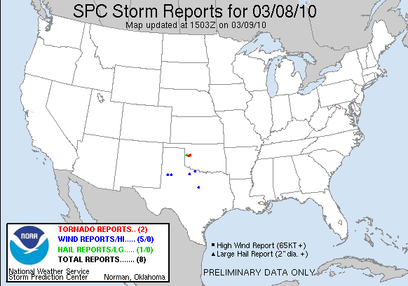
As we got back in the car, I decided to go due north on Highway 34 instead of continuing northwest on 283. I still hoped to catch some hail and more frequent lightning. However, much to our dismay, I turned on the radio and found out that the initial northern storm had already produced a tornado north of Elk City on I-40, and a second one was on the ground! Gutted, we knew we had missed the surprise show of the day, not 50 miles to our north!
Some chasers, having picked a more northern target, saw a beautiful, multi-vortex, stovepipe tornado that was on the ground for some 40 minutes or more before a second tornado touched down. The tornadoes were rated EF2 and EF0 as they damaged some buildings in Hammon and Butler, Oklahoma, but I didn’t hear of any serious injuries.
I am not sure why more storms didn’t form to the south; the greater instability was right about where we were, in southwest Oklahoma. Shortly before the tornado was reported, Storm Prediction Center forecasters issued a Mesoscale Discussion and said they expected a tornado might form considering the stronger vorticity in the area associated with the low. By the time the tornadoes formed, the greatest wind shear was well east of us, so I suppose this was the only hope for a tornado to form. Again, we were probably too far away to catch the storm in time from Altus, but I may always wonder if we could have! I have had little success chasing near lows, but live and learn. 😛
It was still a fun, relaxing chase…up until the point where we knew there was a tornadic storm and we wouldn’t be able to catch up with it…shortly after this, we decided to head home and saw a bit more lightning and a nice rainbow. The next storm setup may not be for another couple weeks…but of course many OU students are optimistic that something may occur during our spring break next week!
See this page for chase accounts and photos of the tornado from other storm chasers. See this page for information and photos from the National Weather Service on the storms and the damage survey.
I will post some non-supercell, non-hail, non-lightning, non-tornado photos on my website perhaps later tonight or tomorrow.

Dean said,
March 14, 2010 at 3:38 am
If i was there we would of got it, on the ground 40 mins is insane we always get on the best storm of the day, sucks u missed it, great write up and cant wait to get over there
Rebekah said,
March 14, 2010 at 2:27 pm
It was a really tough call, though…stay where you think more storms will form, in a potentially better environment–or go after the big storm farther away. It easily could have gone the other way, though, if I’d gone after the big storm, and then better storms formed to the south. 😛