04.13.10
World Wide Weather #3: Rio de Janeiro, Brazil
This week’s featured city, in my series on global weather and climate, is Rio de Janeiro, Brazil.
Located in southeast Brazil, on the Atlantic Coast, Rio is home to about 6.2 million people (approximately 14.5 million in the metro). Rio de Janeiro, Portuguese for “River of January”, was the capital city of Brazil until 1960, when Brasília became the capital. Near the Tropic of Capricorn, Rio is the main tourist destination in the Southern Hemisphere and will host the final match of the 2014 FIFA World Cup and the 2016 Summer Olympics (the first city to host the Olympics in South America).
A few more facts about Rio de Janeiro (from Wikipedia):
- Time zone: Brasília Standard Time (UTC-3) or Brasília Daylight Time (UTC-2)
- Elevation: 0 to 3,350 ft above mean sea level
- Climate zone: Tropical savanna (hot/wet summers, mild/dry winters)
- Average high temperature: 86 °F (30 °C)
- Average low temperature: 68 °F (20 °C)
- Record high temperature: 109 °F (43 °C)
- Record low temperature: 45 °F (7 °C)
- Average annual precipitation: 43 inches (1,090 mm)
Recent/current weather: Last week Rio de Janeiro and surrounding areas were hit hard by heavy rains; reportedly the heaviest rain in nearly 50 years. Rio de Janeiro received about 11 inches of rain within 24 hours on Tuesday/Wednesday. Massive flooding and landslides have sadly resulted in the deaths of over 200 people, and have left thousands without homes.
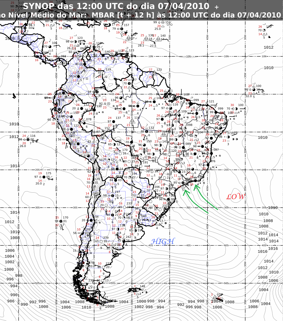
What caused the rain? One big reason has to do with the low-pressure system sitting off the southern Brazilian coast last week (see figure, below). In the Northern Hemisphere, low pressure turns counter-clockwise and high pressure turns clockwise; however, in the Southern Hemisphere, low pressure turns clockwise and high pressure turns counter-clockwise. Thus the strong low-pressure system produced southerly and southeasterly winds in the Rio area, bringing a lot of tropical, moist air from the south Atlantic onshore. Steep terrain around Rio de Janeiro also contributed to the rainfall, as warm, moist air can produce clouds and rain as it rises up a hill or mountain.

Surface analysis of South America on 7 April 2010, at 12Z (9am Rio de Janeiro time). Map courtesy of INMET. Note the 1004 mb closed low off the coast of Brazil, and the 1028 mb closed high off the coast of Argentina. Green arrows denote approximate wind direction. Click to enlarge.
As the low left the area, it was replaced by a high, which is bringing more easterly winds to Rio (this is the typical wind direction in the tropics). As Rio de Janeiro’s coast primarily runs east/west, these easterly winds are assisting in producing some rain, but not nearly as heavy of rain as was associated with the low. In addition, highs are associated with sinking air, so naturally there should not be as much rain.
For more information on Rio de Janeiro, here’s a link to Wikipedia.
For weather maps and information on current and forecast Rio de Janeiro weather, see the Instituto Nacional de Meteorologia (INMET, i.e., Brazil’s National Institute of Meteorology — warning, it’s in Portuguese!) or Weather Online UK (great collection of weather maps and models for all over the world).
Next Tuesday I’ll take a look at the climate and weather in another part of the globe. As always, if you have any comments or suggestions for future cities, please leave a comment on this post!

John F. Hultquist said,
April 13, 2010 at 11:26 pm
In another 5 weeks or so the monsoon ought to begin the sweep northward across India. A number of years ago we watched a video taken from the very southern part and the reporters/photographers moved with the rain as it advanced. They covered the celebrations and customs of the people as the rains came. Very interesting.
I haven’t heard any predictions for this year. Mumbai (formerly Bombay) or Kochi (formerly Cochin), if you need a city to focus on, are on the southeast coast along the Arabian Sea.
When we first took geography classes in the 1960s the explanation for the monsoon had maps with air flow reversals going over the Himalayas in the same sense of a land-sea breeze reversal. When jet streams were discovered and the shifts and splits mapped they started to make some sense of monsoons.
Anyway, you could maybe find something to write about with this.
Cheers, John
Rebekah said,
April 14, 2010 at 11:51 am
Thanks for the suggestion, John; that sounds really interesting! I will look into that for next week. I have found a couple of Indian weather websites, and I noticed one of them had some predictions on the monsoon. I didn’t actually read it yet, but will definitely check that out.