01.12.11
Strong La Niña Continues
Last winter we experienced a moderately strong El Niño (see A Confused Robin and NWS Weather School), which was blamed in part for the snow and ice storms in the southern U.S. and the mild and dry weather in the Pacific Northwest (remember the winter Olympics?).
This winter, however, we are in the midst of a strong La Niña; one of the strongest on record, in fact.
What are El Niño and La Niña?
Normally, trade winds in the tropics blow from east to west. These winds push warm surface waters towards Australia (the western Pacific also has a lower typical surface pressure than the central Pacific, because of convergence occurring when the surface winds reach Australia and other islands). Near Peru, cold water rises up to take the place of the water that was pushed westward (this process is called upwelling).
During an El Niño, the trade winds weaken or possibly even reverse direction. Warm, tropical waters stay warm across the equatorial Pacific and upwelling decreases or stops.
La Niña is sort-of the opposite of an El Niño, where we just see “normal” go a little too far, in a manner of speaking, so upwelling is stronger and cold waters are colder than normal.
Current Events
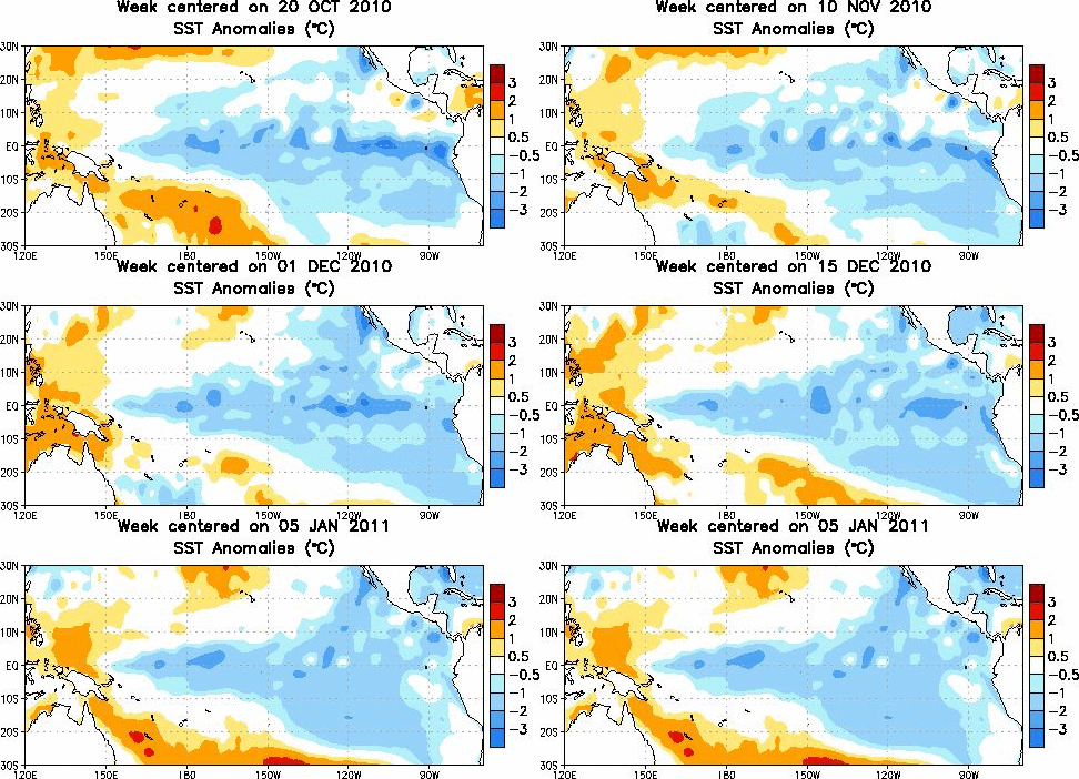
Note in the figure above, from the Climate Prediction Center, the sea-surface temperatures across the tropics have lately been quite a bit cooler than normal, indicating a La Niña pattern.
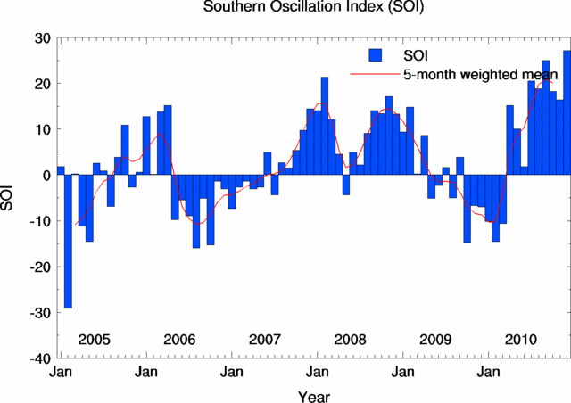
The Southern Oscillation Index (SOI), an Australian Bureau of Meteorology index for measuring the strength of El Niño / La Niña events (subtracts the surface pressure at Darwin, Australia from the surface pressure at Tahiti), has just recorded some of the highest positive (La Niña) values in history, including the highest value ever for December and the highest value since November 1973!
What does this mean for our weather?
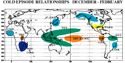
Here’s a typical winter pattern for La Niña, from NOAA (bearing in mind that many other factors and ocean/pressure oscillations may affect the weather):
A couple of things to note: the Pacific Northwest was wetter than normal in December, but not necessarily cooler than normal. The Southwest and south central U.S. was warmer and drier than normal, but the Southeast (in fact all of the East) was quite a bit colder than normal and drier than normal. (To see recent climate maps, check out the CPC page here.)
Also, remember all the flooding going on in eastern Australia? Brisbane, the country’s third largest city, is currently bracing for record flooding. That’s due in some part to La Niña…various low-pressure systems and summer thunderstorms have aided in historic rainfalls and flooding. (Check out this video of cars being swept downstream in a flash flood in Toowoomba, Queensland.) Waters off the East Coast of Australia are also warmer than normal, which would help in producing convective showers.


World Spinner said,
January 14, 2011 at 3:46 am
Green Sky Chaser » Strong La Niña Continues…
Here at World Spinner we are debating the same thing……