01.26.10
Posted in Weather News at 8:12 pm by Rebekah
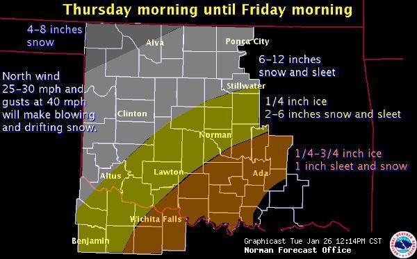
This week the National Weather Center is buzzing with talk of the winter storm Oklahoma is expecting Thursday and Friday. I am not looking forward to experiencing yet another ice storm, but it will be interesting to see just how this one pans out. Initially the models seemed to show that we might get a bit of snow in central Oklahoma, but now there is concern that the low to mid-levels may warm up enough to where we get a significant ice event. Right now the National Weather Service is predicting that Norman will get about 1/4″ of ice and 2-6″ of sleet and snow! It looks like a sure bet that classes will be canceled on Friday and probably Thursday as well. Stay tuned.

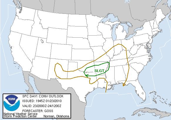
Regarding last weekend’s severe weather, there were a number of high wind reports that verified the slight risk for severe weather that SPC issued, but no tornadoes. I believe there was enough shear, but I don’t think that the instability was great enough to create strong enough updrafts for large hail and tornadoes.
On a side note, I’ve decided to get back to learning more programming. It’s something I’ve dabbled in from time to time, but I’d like to keep up with practicing as much as possible. I’ve got some working knowledge of C and Perl, but I’m also trying to learn Python and Visual Basic, the two key languages used in programming GIS software.
Permalink
01.23.10
Posted in Severe Weather Nowcast at 4:43 pm by Rebekah
My friend Bryan Smith at the Storm Prediction Center recently issued a Mesoscale Discussion for pretty much the region I just outlined (see below). Convection is increasing in this area and the SPC is monitoring the area, considering issuing a Severe Thunderstorm Watch for high winds:
A MID/UPPER SPEED MAX IS RAPIDLY MOVING EWD ACROSS PARTS OF CNTRL AND ERN TX WITH A PRONOUNCED MID-LEVEL DRY INTRUSION DENOTED ON WV IMAGERY NOSING INTO THE ARKLATEX ATTM. SURFACE RESPONSE TO THIS FEATURE IS NOTED WITH 2 MB/HR PRESSURE FALLS ACROSS SERN AR WHERE AN INTENSIFYING LLJ IS FORECAST. FORECAST SOUNDINGS SHOW A MOIST/MARGINAL THERMODYNAMIC ENVIRONMENT…AND WITH TIME…STEEPENING MID-LEVEL LAPSE RATES. STRENGTH OF SHEAR THROUGH THE PROFILE SUGGESTS THE THREAT FOR DMGG WINDS MAY INCREASE THIS AFTERNOON AND SPREAD TO THE NE THIS EVENING. (SPC–Smith)
Permalink
Posted in Severe Weather Forecast at 4:09 pm by Rebekah
Here’s my outlook for the chances of severe weather this evening:
There’s a large trough over the western U.S. today, with a surface low in Nebraska. An occluded front stretches south from the low, through western Missouri and western Arkansas. A cold front extends into eastern Texas while a warm front extends through southern Arkansas into Mississippi.
Southeasterly surface winds are bringing moisture from the Gulf of Mexico into the warm sector in Louisiana and southern Arkansas. Temperatures in the warm sector are in the upper 60s and lower 70s with dewpoints in the upper 50s to mid-60s. Instability isn’t the greatest (CAPE of only about 1000 J/kg in the Arklatex region), and soundings this morning showed a cap over much of the region, but upper-level forcing should be great enough to break the cap. A 250mb jet exists over much of Texas, while a 850mb jet of 50 knots is over the Louisiana/Mississippi border into southeast Arkansas. Positive vorticity advection is occurring around northeast Texas into the Arklatex region. There is also a lot of Q-vector convergence in Louisiana, as well as isentropic lift in Louisiana, Arkansas, and Mississippi.
There is already a line of mostly stratiform precipitation along the occluded and cold fronts, with a few convective cells beginning to grow along and ahead of the cold front. Clouds in the area will limit surface heating, which could be a concern for increasing instability; however, a dry slot is entering the Arklatex region, which could be helpful for cooling the air aloft and increasing lapse rates.
Directional and speed shear is sufficient for rotation, and 0 to 1 km and 0 to 3 km SRH values are over 400 m^2/s^2 (local maxima in southeast Arkansas of 550).
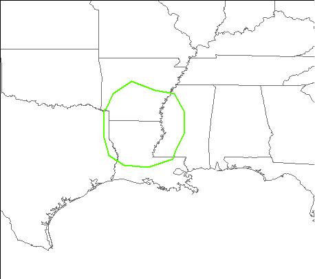
I would expect convection to increase in coverage along the line over the next few hours, with perhaps some strong bow echoes or even a few supercells embedded within the line. I would venture that the greatest threat is hail and high winds, although I would not rule out the possibility of a few isolated tornadoes in southeast Arkansas and northern Louisiana into western Mississippi, especially later tonight provided the low-level jet strengthens even further.
The following map shows where I forecast the greatest severe threat to be this evening/tonight.

As opposed to the latest SPC outlook:

Permalink
01.21.10
Posted in Weather News at 11:54 pm by Rebekah
Last semester when I took Weather Briefing, a 1-credit, 3-day-a-week discussion of weather maps, occasionally my fellow classmates and I would get into a bit of trouble with our instructor for calling the weather “boring” when it was our time to lead the weather discussion. There’s always something going on in the weather world, somewhere on the planet! =) Today, the weather in the U.S. is far from boring.
There is so much to talk about, it’s difficult to know where to start. A 977-mb low continues to hammer California, as the fourth low-pressure system has come ashore at San Francisco. A potent trough assisted in the deepening of the low earlier today. The jet stream is now in a solid El Niño pattern, taking storms on a west-east track across the southern U.S. It’s raining along most of the California coast and Arizona and snowing in the Sierra Nevada and southern Rockies. I imagine all the rain is a result of a combination of a number of a factors: the low, the fronts (occluded front alon the coast, warm front in southern Arizona), a large amount of positive vorticity advection in southern California and southern Arizona, and the fact that these are coastal storms being lifted up coastal mountain ranges. Despite the recent drought, California is certainly not lacking in moisture right now.
There was also enough instability and wind shear combined with the strong lifting in order to produce several tornadoes today, around Santa Barbara, the California/Arizona border, and near Phoenix. There were also a couple of tornadoes today around Huntsville, Alabama, associated with the other low in the U.S. that assisted in bringing some lovely thunderstorms to Norman last night. There’s plenty of instability and lift out there as well, but as I’ve often seen with winter thunderstorms, the thermodynamics and the dynamics didn’t line up very well so the area of greatest shear was displaced from the area of greatest instability and lift. I think this must be a significant reason as to why there were just a few weak tornadoes, rather than any strong tornadoes.
The California system will make it out to the Missisissippi River valley and Gulf Coast in a few days, bringing a chance for more severe weather and potentially some weak tornadoes again. I haven’t looked at that forecast in much detail yet, but that will have to wait.
The Dallas Stars just lost to the Vancouver Canucks, in Vancouver–it was a sad ending, as Dallas was tied at 2 for a while before Vancouver got two goals in the third period. Dallas came back to score one more goal with just 2.8 seconds left, but it was too little, too late. They lost 3-4. The Stars are the only hockey team we get on TV here, so I’ve decided they should be my favorite hockey team (as I didn’t become very interested in hockey until a few years ago, sadly). On a much brighter note, the Mariners signed Felix Hernandez (my favorite Mariners pitcher for several years–he’s their ace now) to a 5-year contract extension, through 2014! The Mariners continue to make great moves in an attempt to finally become a playoff contender again.
Bring on the spring: storm chasing and baseball!! =D
Permalink
01.20.10
Posted in Severe Weather Nowcast at 10:13 pm by Rebekah
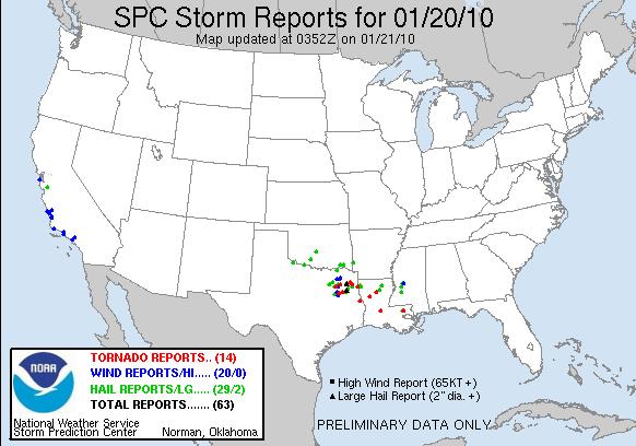
The first severe storm watches of the year were issued today–tornado watches 1 and 2–for northeast Texas, Louisiana, and west central Mississippi. 14 tornadoes have been reported so far–see the map below.

Yesterday I thought there would be more hail reports in northeast Texas, with perhaps an isolated tornado or two, while I thought Louisiana would have more tornadoes because of the greater predicted wind shear.
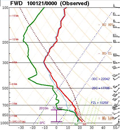
There still is greater shear in Louisiana. However, the Dallas sounding looks great to me in terms of instability and moisture, but although the wind profile doesn’t look terrible, it doesn’t look the best either (see below).

I’m going to keep this short today, as Norman is experiencing some exciting January thunderstorms today as well; we got a little bit of pea-sized hail and lightning earlier this evening, and it looks like more lightning is on its way. The storms in our area are mostly forming just east of the shortwave trough (see below). Back to watching lightning!


Permalink
« Previous Page — « Previous entries « Previous Page · Next Page » Next entries » — Next Page »
