01.19.10
Posted in Severe Weather Forecast, Severe Weather Post-analysis at 8:17 pm by Rebekah
As a follow-up to Sunday’s post, the rain continues to fall in California and now into Arizona. There were a few high wind reports in California today, including 75 mph wind gusts around San Francisco and a 93 mph wind gust near Los Angeles. Furthermore, there were three tornadoes reported around L.A. this afternoon! I’m not certain at this point how they formed. Instability and wind shear were not great in the area; in fact, the environment around San Francisco looked more favorable for tornadoes. I suspect there must have been just enough shear to spin up the brief tornadoes within the storm complex.
As for the potential of severe weather in the southern Plains, dewpoints are already in the lower 60s in eastern Texas and the Dallas/Fort Worth sounding showed a fairly unstable atmosphere this evening, and shear was pretty good, but there was a significant capping inversion. If clouds were not so thick over Oklahoma and Texas, temperatures would have been a little warmer today and there would have been a decent chance for some strong thunderstorms in southeast Oklahoma and east Texas.
Tomorrow’s severe weather setup could be interesting. Based on instability and lift along the cold front, I would think that the greatest chance for severe thunderstorms would be somewhere along I-30 from Dallas to Texarkana. Low-level shear in this area is not bad, but based on the forecast hodographs I would think that the main threat is hail. Shear is forecast to be much greater in Louisiana, but soundings appear to be saturated up to the tropopause. Provided that there are some organized thunderstorms around the mesoscale convective system, I would not be surprised to see a few rain-wrapped tornado reports around the Louisiana/Mississippi border.
Permalink
01.17.10
Posted in Weather News at 9:25 pm by Rebekah
The jet stream has recently shifted from its meridional (north-south) pattern to more of a zonal (west-east) pattern, preventing the cold air up in Canada from diving south and allowing much of the U.S. to warm up a bit.
This weather pattern also means more coastal storms for the West Coast, especially California.
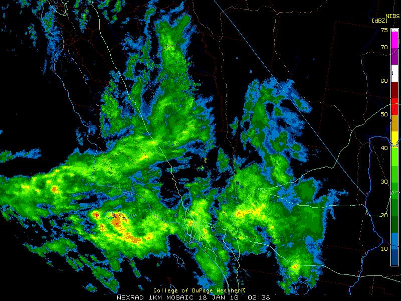
Take a look at the following radar image of southern California this evening (6:38 pm Pacific Time).

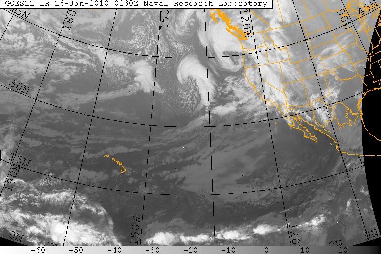
Now look at the following infrared satellite image over the Pacific Ocean, showing a few more storm systems (extratropical cyclones) heading eastward.

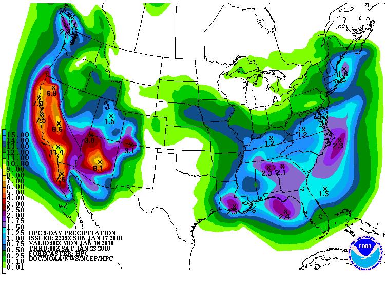
How much rain may be in store for the coast? The Hydrometeorological Prediction Center (HPC) is predicting just over 11 inches between Los Angeles and San Diego just from tonight through Friday night (below)! Shortwave troughs embedded within the flow of the jet stream are responsible for much of the expected rain (and snow in the mountains). Upper-level divergence is found downstream of a trough, causing and/or enhancing upward motion and the development of low-level convergence (hence a surface low pressure system). These shortwaves are also going to bring thunderstorms (potentially severe!) to eastern Texas on Wednesday.

Albert Hammond was right when he sang, “It never rains in California, but girl don’t they warn ya. It pours, man it pours.”
Permalink
01.05.10
Posted in Weather News at 1:17 pm by Rebekah
So says the National Weather Service, Norman OK forecast office!
The statement, copied and linked below, states Oklahoma is expecting the coldest temperatures in a decade! The weather forecast is calling for highs in the teens, lows near or below zero Thursday/Friday, with wind chills as low as -20F!! Time to stay inside, curled up on the couch with some hot cocoa and my cat.
I’m sitting at the Tri-Cities, Washington airport at the moment, about to fly to Salt Lake City, and then on to Oklahoma City. I can’t say that I’m looking forward to being greeted by an arctic airmass, and some of the coldest temperatures (or at least wind chills) that I’ve ever experienced, but maybe it will allow my cat and I to spend some quality time inside together. 🙂
Here’s the statement:
Get Ready for the Extreme Cold!
The National Weather Service is forecasting the coldest air we’ve seen in more than a decade. It arrives late Wednesday and will be here into the weekend.
It is likely that many places will see wind chill values (how cold it actually feels when you combine temperatures and the wind) at or below zero continuously for 18 to 24 hours or more.
Here are some links with more information on the expected cold snap and how you can stay safe and informed:
What’s expected and how to prepare – Statement from NWS Norman
Will we break a record? – Statement from NWS Norman
Wind Chill Index – General Information
Wind Chill Index – Frequently Asked Questions
Staying Safe in Extreme Cold – CDC Guide
How to make your own customized hourly forecast
NWS Norman Enhanced Web Page


Permalink
01.03.10
Posted in Weather News at 3:13 pm by Rebekah
Under the grip of an unusually cold airmass for this time of year, much of the eastern US is experiencing temperatures remain well below average.
The National Weather Service recorded a temperature of -38 °F at Grand Forks, North Dakota early Saturday morning; factoring in winds of 8 mph when the air temperature was -36 °F (winds were calm when the temperature was at its coldest) yields a wind chill of -58 °F (-50 °C)!!
International Falls, Minnesota set a record temperature of -37 °F early Saturday, only to tie it early this morning! The NWS is currently predicting a low of -33 °F in International Falls tonight, so there is a chance they will tie that new record again, if not break it.
Lake-effect snow continues across the Great Lakes, and heavy snow continues throughout the New England area as the 978 mb low-pressure system off the Northeast Coast refuses to show signs of going anywhere fast.
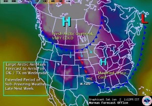
An even colder arctic airmass will quickly surge southward along the Rockies into the Plains Tuesday night through Wednesday. I fly back to Oklahoma on Tuesday and it looks like I will get there just in time to experience perhaps some light snow along the cold front Wednesday night and the coldest temperatures of the season so far Thursday night/Friday morning (8 °F with wind chills as low as -10 °F). Brr! I can’t say I’m a fan of the cold weather; Oklahoma weather is just about right for me, as the area gets just enough cold weather and wintry precipitation to keep me happy, but not so much that I get tired of it (a little more snow from time to time would be nice, though–but I missed the big Christmas Eve Blizzard!).

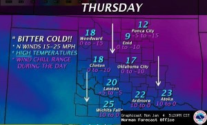
NWS graphic forecast of arctic blast on Wednesday.
Permalink
01.02.10
Posted in General News at 10:47 pm by Rebekah
Happy New Year! With the start of the new year, I’d like to get back to updating my website and posting on my blog more often. I was very busy this past semester, but I plan to greatly improve this website and blog before the new chase season starts, potentially in just a couple of months! I also plan to improve my knowledge of chasing and my arsenal of chase equipment soon…including a new HD camcorder (the old one isn’t HD), a new GPS unit and mapping software (the GPS is broke and the old CDs I had don’t work on Vista–go figure), and possibly a new data plan so that I can connect my laptop to the Internet while on the road. I already have one new piece of equipment I’ve long wanted–my first DSLR camera! It’s a Nikon D3000, with two lenses that help take incredibly sharp photos. It was partly a Christmas gift from my parents, and partly a gift from myself. 🙂
Yahoo! recently moved their blogging support from Movable Type to WordPress, and I neglected to switch my files over before they removed my access. Thus I had to start a new blog, and that’s what you’re looking at now. Unfortunately, I don’t think I can move my old posts and comments to this one.
Welcome to the new blog, and please stay tuned for updates!
Permalink
« Previous Page « Previous Page Next entries »
