03.20.10
Tropical Cyclone Ului Makes Landfall in Australia
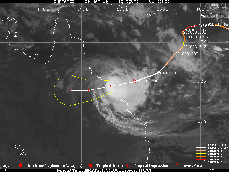
Severe Tropical Cyclone Ului made landfall in Queensland today (about 1:30am Sunday, local time), on the northeast coast of Australia. With a central pressure of 964 mb, the cyclone brought sustained winds of over 90 km/hr (56 mph) and wind gusts of 205 km/hr (128 mph) to the coast. According to the Australia Bureau of Meteorology, this is a Category 3 tropical cyclone. According to the National Hurricane Center in the US, this would only be a tropical storm. Why the large discrepancy in ratings?
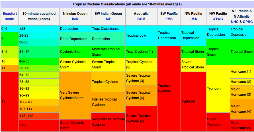
Tropical cyclones have different names in different ocean basins; in the North Atlantic, a strong tropical cyclone is called a hurricane, while in the Northwest Pacific, a strong tropical cyclone is called a typhoon. Tropical cyclones also have different ratings in different ocean basins, each based on a set of criteria developed by the agency that monitors the storms in their particular region.
The table below (click to enlarge) shows worldwide ratings for tropical cyclones by ocean basin and agency (courtesy of Australia Severe Weather; they reportedly got it from Wikipedia).
You may notice that the NHC ratings look a little different from what you may be used to. Note that these classifications are based on the 10-minute average wind speed in knots (1 knot = 1.15 mph), while the NHC’s Saffir-Simpson Scale is based on a 1-minute average wind speed…thus the wind speeds in this table have been “downgraded” to fit the 10-minute average that most everyone else in the world uses.
For more information on Australia’s particular rating system, see the Bureau of Meteorology page about tropical cyclones. For information on current tropical cyclones around Australia, see this Bureau of Meteorology page on tropical cyclones. For information on current tropical cyclones in the Pacific and Indian Ocean, see the Joint Typhoon Warning Center.
Severe Tropical Cyclone Ului at 1530UTC (2:30am local time in Queenland); infrared satellite image courtesy of the University of Wisconson-Madison.


Green Sky Chaser » Hurricane Alex at Landfall said,
July 1, 2010 at 2:12 pm
[…] you’re interested in seeing how other countries rate hurricane strength, I posted a bit on this in March. GOES visible satellite image of Alex at 5:45 pm CDT on 30 June, 3 hours from […]