03.24.10
Posted in Weather News at 4:36 pm by Rebekah

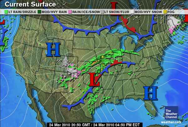
While Denver digs out from nearly two feet of snow in places and attempts to restore power to thousands of homes and businesses, central Texas is experiencing some strong thunderstorms. There is currently a severe thunderstorm watch box out for north central and central Texas, but instability and vertical, directional wind shear is not great enough for very severe thunderstorms. The thunderstorms are currently forming along a cold front (see map, above).
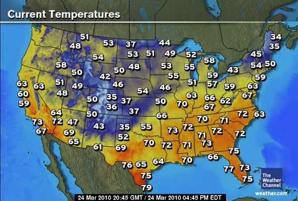
Most of the cooler air in the US (see below) is currently confined to the Colorado Rockies (as well as Maine; they are under a snowstorm as well right now).

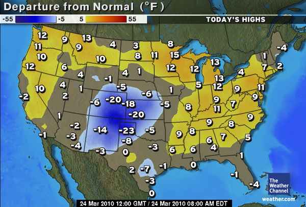
To see how today’s forecast highs (by The Weather Channel) stack up against the normal (or average) highs for today, see the map below. You can see that Colorado, Kansas, New Mexico, and the Texas Panhandle are well below average, while much of the rest of the US is (finally) near or above average. Yay.

The big question remains, when will there be some good, chase-able severe thunderstorms within my region again? There are a few interesting-looking troughs that may move through in the first week of April, but it appears that a lack of moisture and instability may still be a big problem. Obviously the models can and will change before then, but the first decent chance of a big severe weather day may not be until mid-April or so. In the meantime, that gives me more time to get work done and write blog posts about nothing much in particular. 😉
Permalink
03.23.10
Posted in Non-US Weather, Weather News at 3:20 pm by Rebekah
Today marks the start of a series of posts on global weather. Most of us, understandably, are most concerned with the climate and weather in our particular neck of the woods; however, I think it can be both fun and educational to take a look at weather in other parts of the globe.
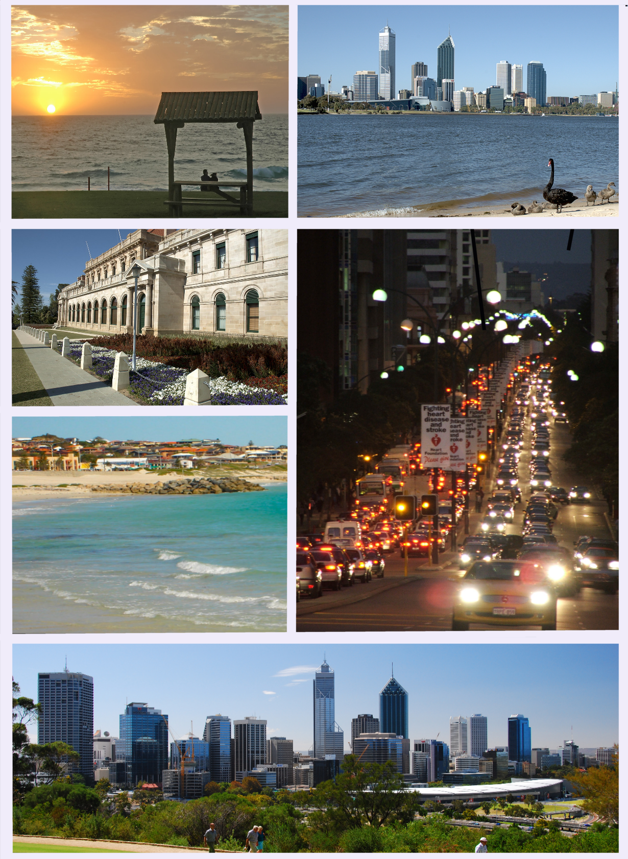
This week’s featured city is Perth, Australia.

Perth, Australia. Courtesy of Wikipedia.
Home to over 1.6 million people, Perth is the capital of and largest city in the state of Western Australia. A few facts about Perth:
- Time zone: Australian Western Standard Time (UTC+8)
- Elevation: Sea level
- Climate zone: Mediterranean (hot/dry summers, cool/wet winters)
- Average high temperature: 76 °F (24.5 °C)
- Average low temperature: 55 °F (12.7 °C)
- Record high temperature: 115 °F (46.2 °C)
- Record low temperature: 31 °F (-0.7 °C)
- Average annual precipitation: 33.6 inches (852.6 mm)
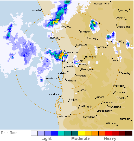
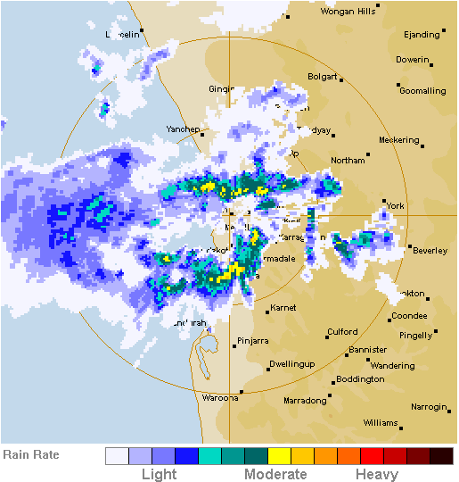
Recent weather: Late Monday afternoon (March 22), Perth was hit by several severe thunderstorms that brought golfball-sized hail (1.75-inch-diameter), heavy rain, flooding, landslides, lightning, and wind gusts of over 75 mph. Damage from the storms is estimated at $100 million. Perth receives on average about 0.8 inches of rain in the month of March, and almost all of this rain fell in less than 10 minutes yesterday. A total of 1.6 inches of rain fell in the afternoon and evening.
A low-pressure trough came ashore in the afternoon, sparking the formation of several strong thunderstorms (see radar images, below, from the Bureau of Meteorology).

Perth radar at 0750UTC on 22 March 2010 (3:50 pm local time).

Perth radar at 0850UTC on 22 March 2010 (4:50 pm local time).
Forecast weather: High pressure is headed for the West Coast of Australia, so warm and dry conditions are expected to persist in Perth throughout this week. According to the Bureau of Meteorology, highs are forecast to range from near 84 °F to 90 °F under mostly sunny skies, with lows ranging from 57 °F to 66 °F.
For more information on Perth, here’s a link to Wikipedia.
For more information on the recent severe thunderstorms, here’s a BBC news article, and here’s a news article from The West Australian.
For weather maps and information on Perth weather, see the Australian Bureau of Meteorology.
Next week I’ll take a look at the climate and weather in another part of the globe. If you find these posts interesting or helpful, if you have suggestions, or if you have a city or country you’d like to recommend for next time, please leave a comment!
Permalink
03.22.10
Posted in Weather Comics at 12:35 pm by Rebekah
Foxtrot comic on 19 June 2006.

Permalink
03.21.10
Posted in Weather News at 4:34 pm by Rebekah
The several-inch snowstorm and blizzard predicted for central Oklahoma was largely a bust.
In short, there wasn’t enough moisture for large snowflakes to form, so we just got a light snowfall with tiny flakes all day. The wind lived up to its billing, though; sustained winds yesterday (and today) were mostly in the 20s (the highest I saw was 31 mph) with gusts in the 30s (the highest was 40 mph). This brought the wind chill temperatures down to the low teens, so it felt quite cold last night!
Patrick Marsh (a fellow meteorology grad student at OU) has a nice write-up about the (lack of) winter storm on his blog.
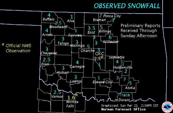
We only got about an inch of accumulation in places around Norman, and I think most of that was from blowing snow. Snowfall totals were more accurate further north and east, though. See below for the NWS current observed snowfall totals.

It looks like we’ll be under a ridge for most of this coming week, so temperatures will quickly warm up again to the 60s.
In other news, the Iditarod finished up yesterday; defending champion Lance Mackey won his fourth race on Tuesday, and the final musher, Celeste Davis, rode in to Nome yesterday. It has warmed up to a toasty 20 °F in Nome.
Classes at OU start again tomorrow. Although I didn’t go anywhere outside Norman or Oklahoma City, or take too much time off, I did have a fairly relaxing, nice spring break. It’s hard to believe that there’s only another 7 weeks of class before summer…
Permalink
03.20.10
Posted in Weather News at 12:46 pm by Rebekah
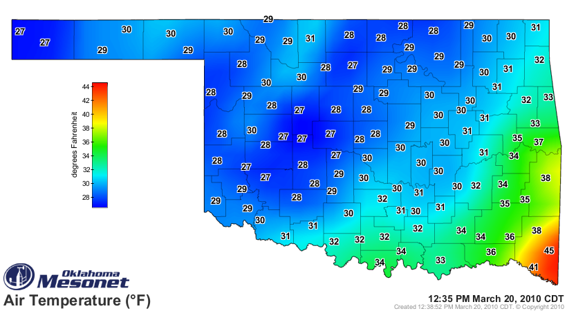
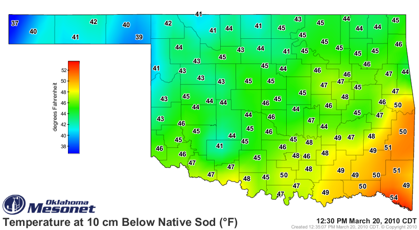
Did central Oklahoma get snowed in? Did we get the 4-6 inches of snow predicted? As of now (12:40pm local time), I see only puddles of liquid water in my apartment parking lot, and a dusting of snow in the grass. Light snow is still blowing around as the winds are strong, but no good accumulation to speak of. More snow could come tonight, but how can it stick when the ground is so warm? That’s the problem with forecasting snow this time of year; you may think there will be 4-6 inches of snowfall, but in terms of accumulation, next to nothing on the roads! Nevertheless, I didn’t go to the wedding in Tulsa today; snow and ice is worse up there, and decided last night to not risk it.
Air temperature at 12:35pm local time (courtesy of the Oklahoma Mesonet):

Soil temperature at 12:30pm local time (courtesy of the Oklahoma Mesonet):

Permalink
« Previous Page — « Previous entries « Previous Page · Next Page » Next entries » — Next Page »
