03.20.10
Posted in Non-US Weather, Tropical Weather, Weather News at 12:37 pm by Rebekah
Severe Tropical Cyclone Ului made landfall in Queensland today (about 1:30am Sunday, local time), on the northeast coast of Australia. With a central pressure of 964 mb, the cyclone brought sustained winds of over 90 km/hr (56 mph) and wind gusts of 205 km/hr (128 mph) to the coast. According to the Australia Bureau of Meteorology, this is a Category 3 tropical cyclone. According to the National Hurricane Center in the US, this would only be a tropical storm. Why the large discrepancy in ratings?
Tropical cyclones have different names in different ocean basins; in the North Atlantic, a strong tropical cyclone is called a hurricane, while in the Northwest Pacific, a strong tropical cyclone is called a typhoon. Tropical cyclones also have different ratings in different ocean basins, each based on a set of criteria developed by the agency that monitors the storms in their particular region.
The table below (click to enlarge) shows worldwide ratings for tropical cyclones by ocean basin and agency (courtesy of Australia Severe Weather; they reportedly got it from Wikipedia).
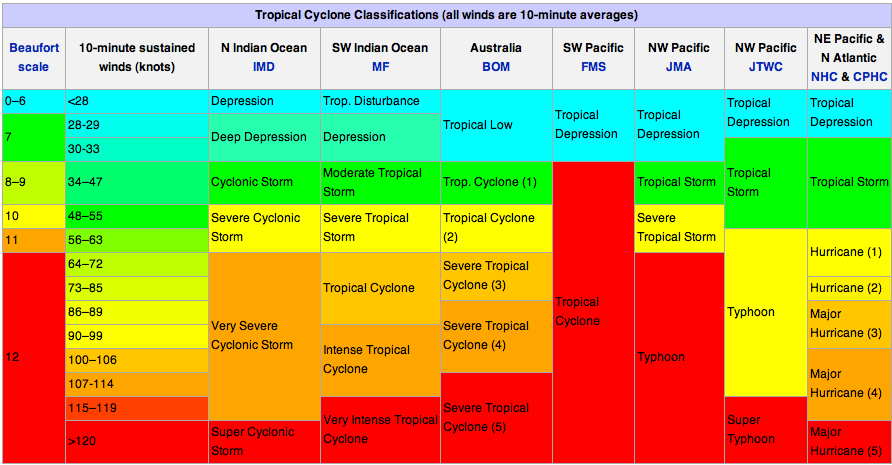
You may notice that the NHC ratings look a little different from what you may be used to. Note that these classifications are based on the 10-minute average wind speed in knots (1 knot = 1.15 mph), while the NHC’s Saffir-Simpson Scale is based on a 1-minute average wind speed…thus the wind speeds in this table have been “downgraded” to fit the 10-minute average that most everyone else in the world uses.
For more information on Australia’s particular rating system, see the Bureau of Meteorology page about tropical cyclones. For information on current tropical cyclones around Australia, see this Bureau of Meteorology page on tropical cyclones. For information on current tropical cyclones in the Pacific and Indian Ocean, see the Joint Typhoon Warning Center.
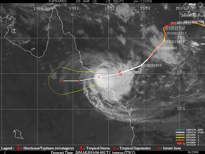
Severe Tropical Cyclone Ului at 1530UTC (2:30am local time in Queenland); infrared satellite image courtesy of the University of Wisconson-Madison.
Permalink
03.19.10
Posted in Weather News at 10:40 am by Rebekah
So, tomorrow is the first day of spring. Hurray! No more snowstorms in the south! Warm weather can return!
Almost.
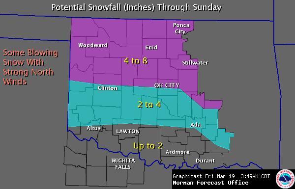
The temperature is forecast to reach 70 in Norman today, and will be in the 60s early next week. However, as to this weekend…see below (courtesy of the National Weather Service Norman Forecast Office).
Yuck.
I’m not quite sure about Norman, but according to the NWS, Oklahoma City is just 4.6 inches away from receiving the most snow in a year in recorded history…and we just might break that record.
A low is moving through northern Texas and a cold front through northwest Oklahoma today, bringing the chance of some thunderstorms to the area. Some of these thunderstorms may be severe, at least in terms of hail. Moisture is still a problem, though, so it looks like this event will be marginal at best.
Overnight into Saturday, the front will make its way across Oklahoma, causing temperatures to drop steeply. Moisture will also be sufficient for some precipitation in the form of snow. Most of the snow looks like it will fall on Saturday into Saturday night. North winds behind the cold front will be strong enough to blow the snow around and cause drifting.
Good news? We have the chance to break the annual snow record and then it should all melt in the next one to two days.
Bad news? This cold front, as well as a weaker cold front perhaps mid- to late next week, will scour the Gulf of moisture. This means we have to wait longer to get sufficient moisture return (i.e., southerly winds that bring moisture up from the Gulf of Mexico) before the next severe weather setup (sometime in April?).
Worst news? I’m planning on going to Tulsa tomorrow for a friend’s wedding, and then coming back to Norman for another friend’s birthday party…provided that road conditions are not too hazardous…
Permalink
03.18.10
Posted in Uncategorized at 2:50 pm by Rebekah
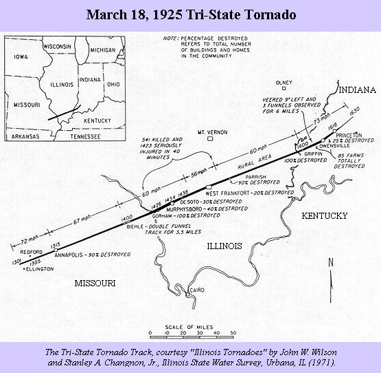
March 18, 1925.
85 years ago today, a large tornado tore through Missouri, Illinois, and Indiana, killing 695 people over 3.5 hours on its 219-mile path.
Over 15,000 homes were destroyed by the F5 tornado, and total damage was estimated at $16.5 million (about $1.5 billion today).
Little was known about tornadoes in 1925, let alone weather forecasting. There was no tornado warning system, so people in the path of the tornado would not know what was coming (unless, perhaps, they were very far along the path and somehow heard about it coming their way). The Tri-State Tornado was not the only tornado on this day; several other tornadoes were reported in the region, bringing the total death toll to some 750 or more, and leaving over 2000 people injured.
Tornado prediction is still far from perfect, but has come a long way since 1925. Tornado warnings may now be issued at an average of 15-20 minutes before tornado formation. Tornadoes such as the Tri-State Tornado, although tragic, do assist in advancing our knowledge of tornadoes and tornado prediction, so we can hopefully help more people next time. If a similar tornado were to occur today, the death toll and perhaps amount of damage would be a lot lower.
However, let us not forget those who lost their lives to this monster tornado.
For more information, check out the Wikipedia article on the Tri-State Tornado, including the references list at the bottom of the page.
Permalink
03.15.10
Posted in Non-US Weather, Weather News at 9:45 pm by Rebekah
Last Saturday, March 6th, several strong thunderstorms swept through Victoria, Australia (the southeast part of the country). The largest storm was a supercell, a rotating thunderstorm that pummeled Melbourne and surrounding areas with heavy rain and 1- to 4-inch hail.
Here’s a radar image, courtesy of the Australian Bureau of Meteorology, showing the line of thunderstorms at 0348Z, or 2:48pm local time (the southernmost cell is directly over Melbourne at this time):
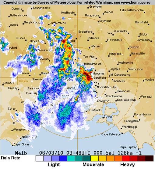
In the Melbourne metropolitan area, 1.8 inches (46 mm) of rain fell within 15 to 30 minutes, causing massive flooding. Here’s a video someone took of the hailstorm and the downpour.
2- to 4-cm hailstones were common across south Victoria. The largest hailstone was 10 cm (nearly 4 inches) in diameter.
Here’s another video (from an Australian news source) where the storm is described and shown.
The storms formed along a low pressure trough in southern Australia (see map below):
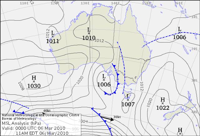
The Bureau of Meteorology has a great write-up on this here.
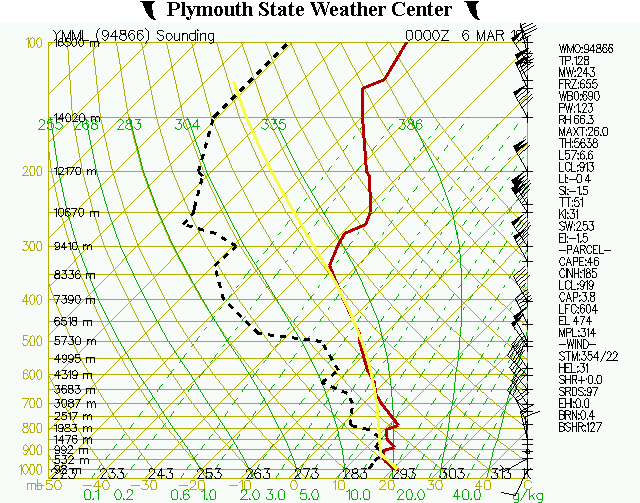
Finally, here’s a sounding taken from Melbourne at 00Z (11am local time), courtesy of the Plymouth State Weather Center, a few hours before the storms hit. It’s not a bad thunderstorm profile, but the instability could be greater…note than when the bold yellow line is to the right of the red line (temperature profile), that means that a rising parcel of air is warmer than the environment…so a lifted parcel would rise (unstable atmosphere)…
Permalink
03.14.10
Posted in Weather News at 4:19 pm by Rebekah
In case you hadn’t heard, major flooding is going on in the Northeast. Heavy rains and strong winds are wreaking havoc and knocking out power to thousands of people. Why?
Remember my post on Thursday, regarding rex blocks? The extratropical cyclone that brought tornadoes to the central US several days ago has been prevented from leaving the country, because of a large ridge over the eastern US. Even a “normal” cyclone would cause problems if it were to sit over the same spot for a while.
As a followup to Thursday’s post, I now have to post what the actual 500-mb map looked like this morning, so we can see how well the model did on predicting this setup (the models don’t usually handle blocking patterns very well). The following map is from 12Z this morning, courtesy of UCAR.
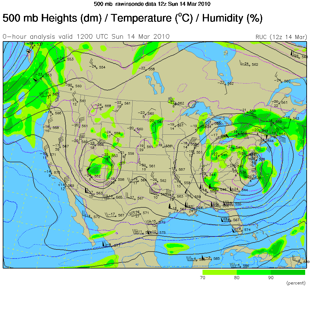
Large low centered over western North Carolina and Virginia? Check. Smaller low just east of the four corners? Check. Ridge of high pressure centered just north of Ontario, over Hudson Bay? Check. Closed high over Ontario? Check (much smaller, and offset a bit, but still there). Even the pressure height values match up perfectly, or close to perfectly. Wow, I’d say the GFS model did very well, considering it’s a blocking pattern, and I first noticed it a full 72 hours out! This may not be a full, perfect rex block in the sense of a large closed high north of a large closed low, but it’s definitely a high over low block, and a beautiful one at that (unless you live along the East Coast, then maybe not quite so beautiful).
Tomorrow’s post: hail storms in Melbourne last week.
Permalink
« Previous Page — « Previous entries « Previous Page · Next Page » Next entries » — Next Page »


