05.26.10
Posted in General News, Weather News at 2:45 pm by Rebekah
The Big 12 baseball tournament starts tonight in Oklahoma City.
OU, at second in the Big 12, will be taking on number seven Kansas tonight at 7:30pm. There are two pools in the tournament, each with four teams. After each team plays every team in their pool, the two teams with the best records in their pools will advance to the Big 12 Championship game on Sunday. I have yet to go to a college baseball game, but wish I would have taken the opportunity to go to a few games this spring, especially as three of the students that I taught last fall are on the baseball team (Garrett Buechele, Zach Neal, and Erik Ross).
Third baseman Garrett Buechele is doing very well this year, batting .387. Garrett’s father, Steve Buechele, played major league baseball for the Rangers, Pirates, and Cubs. Right-handed pitcher Zach Neal is also doing very well, with 8 wins and only 2 losses, and an ERA of 4.15. Zach will be starting OU’s second game of the tournament.
Some friends and I plan on going to tonight’s game at Bricktown Ballpark (home of the Oklahoma Redhawks).
BOOMER SOONER!!!!!
————————–
In other news, I finally bought Adobe Dreamweaver (it’s one of the best and least expensive [with a student discount] web design programs out there). I have been using MS Publisher for my website so far, but it certainly was not designed for website development. I am excited to be able to play around with Dreamweaver now, and to make the Green Sky Chaser site both nicer for viewers and easier for me to work on.
It may take me a while to figure out how to use the program, but within the next month I may be giving the site a bit of a facelift (perhaps for the one-year anniversary, coming up in late June?).
As I will be focusing my web development time on this, I may not get around to posting the May 19 chase log and photos as soon as I had hoped. I may, however, try to take some time to get that done by or over the weekend.
————————–
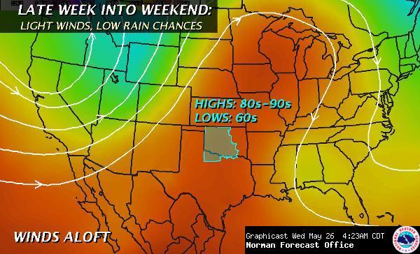
In the meantime, here’s a look at our nice, summer-like Oklahoma weather lately (courtesy of the NWS Norman):

Permalink
05.25.10
Posted in Non-US Weather, Weather News at 4:47 pm by Rebekah
After taking a 6-week break in my global weather and climate series, in order to focus on work and posts on storm chasing, I’m finally coming back to the series.
Here’s what continents I’ve done so far (my goal was to pick a different continent each week, cycling through all seven for as long as there is interest in the series).
#1 – Australia (Perth, Australia)
#2 – Europe (Edinburgh, Scotland)
#3 – South America (Rio de Janeiro, Brazil)
This week, for the fourth post in the series, I will take a look at Kochi (formerly known as Cochin), India.

Kochi, India (image courtesy of Wikipedia).
Located in southwest India, on the coast of the Arabian Sea, Kochi is home to about 600,000 people (approximately 1.5 million in the metro). Kochi, sometimes known as the “Queen of the Arabian Sea”, has long been one of the most important spice trading centers on the Arabian Sea. As the first European colonial settlement in India, Kochi was the capital of Portuguese India for nearly 30 years in the early 16th century. Growth in shipping industries, tourism, and information technology have continued to boost Kochi’s economic growth.
A few more facts about Kochi (from Wikipedia; some weather data from Weatherbase):
- Time zone: India Standard Time (UTC+5:30)
- Elevation: 0 ft above mean sea level
- Climate zone: Tropical monsoon (hot/wet summers, warm/moist winters)
- Average high temperature: 86 °F (30 °C)
- Average low temperature: 77 °F (25 °C)
- Record high temperature: 100 °F (38 °C)
- Record low temperature: 63 °F (17 °C)
- Average annual precipitation: 108 inches (2,740 mm)
The forecast for Kochi this week is thunderstorms every day with highs in the low to mid-80s and lows in the mid- to upper 70s. Why is it so stormy? Note also that Kochi receives over 100 inches of rain per year, and most of that rain comes during the summer months (June to September).
A seasonal shift in winds, resulting in a seasonal shift in precipitation, is called a monsoon.
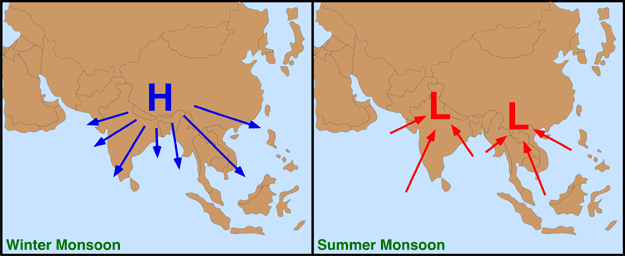
Put most simply, water has a higher heat capacity than land, so in the summertime, the Indian peninsula heats up more than the surrounding water. This warmer region of air starts to rise (often aided by the Himalayas), creating a low pressure system. The low pressure, in turn, draws the moist air from the sea in towards the land, thus allowing many thunderstorms to form and much rain to fall (see figure below).
In the wintertime, the land cools down faster than the water. A surface high pressure system forms over the land, and blows air out to sea, keeping India drier than it would be otherwise (see figure below).

Winter and summer monsoon patterns for southeast Asia (courtesy of physicalgeography.net).
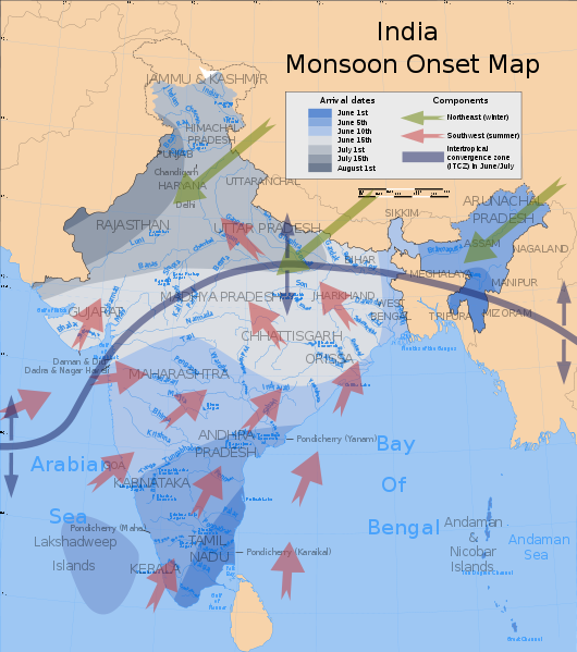
The following figure illustrates the approximate dates for the southwest summer monsoon to arrive at different regions of India.

Southwest summer monsoon onset map (courtesy of Wikipedia).
As you can see, the monsoon should soon be arriving at Kochi (Kochi is in the state of Kerala). The India Meteorological Department (IMD) posted the following Monsoon Watch last night:
“The Northern limit of Monsoon (NLM) continues to pass through Lat.5.0°N/ Long.70.0°E, Lat.5.0°N/ Long.75.0°E, Lat. 8.0°N/Long. 80.0°E, Lat. 12.0° N/ Long. 84.0°E, Lat. 15.0° N/ Long. 87.0°E, Lat. 18.0° N/ Long.90.0°E and Lat. 21.0° N/ Long. 93.0° E.”
Note that Kochi is located at about 10°N and 76°E, meaning the northern edge of the monsoon is just a few degrees south and east of Kochi at this time.
I have heard some predictions that the monsoon should be getting off to a good, rainy start this year (more so than last year, anyway), especially as there is currently a heat wave going across northern, western, and central India with temperatures peaking at about 50°C (122°F).
Weather Trends International has some information on the monsoon outlook, as well as some maps showing forecast precipitation totals by month.
For more information on Kochi, here’s a link to Wikipedia.
For weather maps and information on current and forecast Kochi weather, see the India Meteorological Department (don’t worry, it’s in English!) or Weather Online UK (great collection of weather maps and models for all over the world).
Next Tuesday I plan to take a look at the climate and weather in another part of the globe. We still have North America, Africa, and Antarctica before starting over again. As always, if you have any comments or suggestions for future cities, please leave a comment on this post!
Permalink
05.23.10
Posted in Uncategorized at 7:38 pm by Rebekah
Photos and a full chase log from May 18 are up on the website; however, you may want to wait to access the photo page…
Unfortunately, as soon as I copied over the photos and updated chasing pages, I lost access to my ftp site and I can’t seem to get it back right now. This has prevented me from copying over the updated home page and full page for displaying the May 18 photo thumbnails. It’s rather frustrating, but it would appear that I will just have to wait and hope I am able to access it again soon. You can still go to the website, click on the storm chasing tab, and go to the May 18 photo page…it just looks funny right now as the thumbnails are not showing up and the background is white.
Hmph.
If you wait to look at the page until tomorrow, hopefully I will have been able to copy over the full photo page to make it look nice. If not, you’ll know why.
Photos and a chase log from May 19 should be up sometime early this week.
On a related note, when reviewing photos to post this afternoon, I compared the NWS Amarillo tornado reports and survey info from Tuesday with the timestamps on my photos. I found that one of the tornadoes occurred as I took a few photos after the mesocyclone left Dumas.
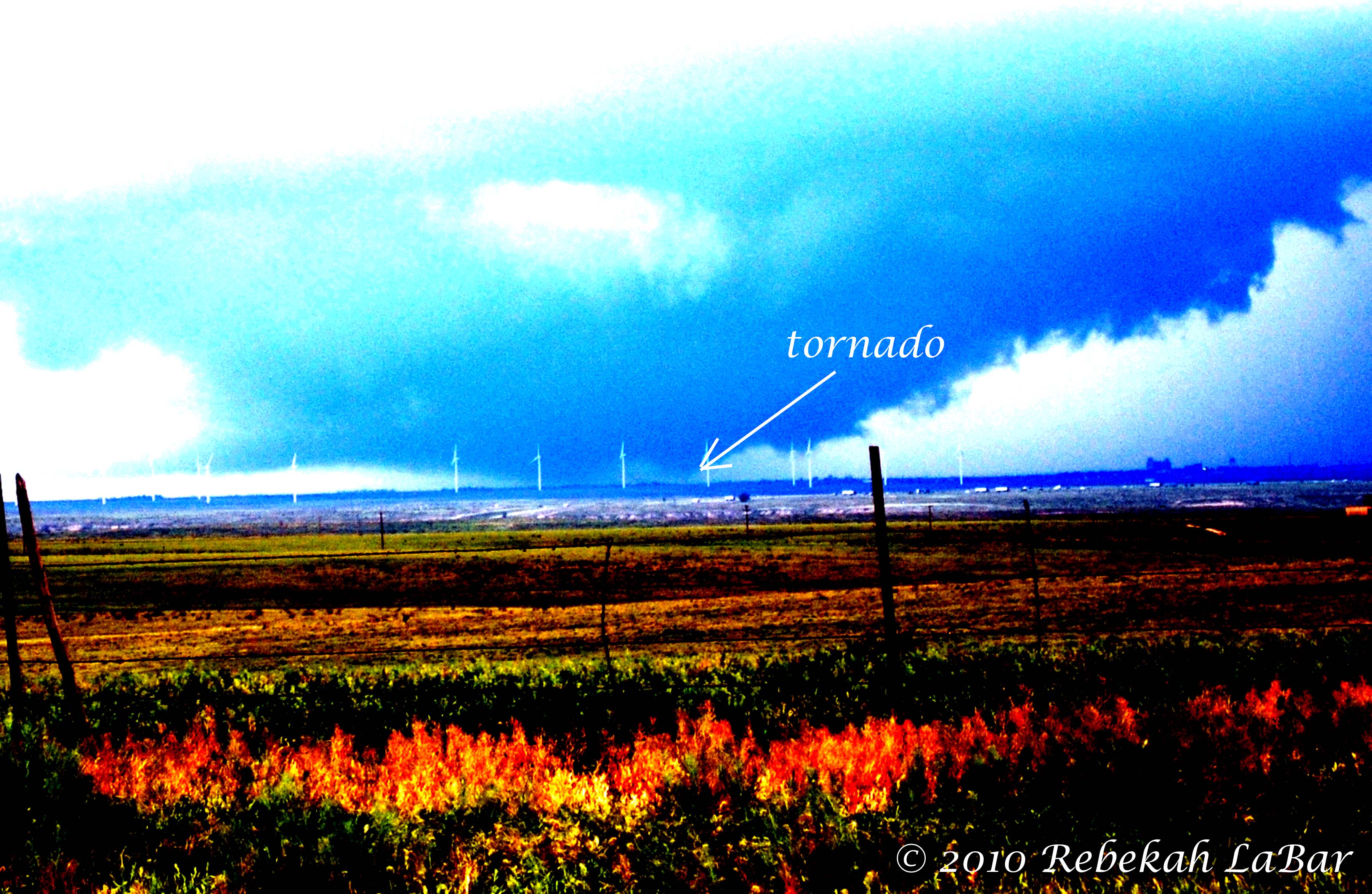
According to the NWS, there was a 200-yard tornado 2 miles east of Dumas from 6:42 to 6:45 pm. I was several miles south of the storm, looking north to the area just east of Dumas, when I saw one of many bowl-shaped lowerings. I was too far away to tell if it was a tornado or not, but I snapped some photos. One of the photos, taken at 6:43 pm, shows a cone tornado on the ground! I had to enhance the contrast in the photo by quite a bit, but hey, sometimes that’s what you need to know for sure…
As the time, location, and description matches, and the funnel cloud in my enhanced photo was indeed touching the apparent ground, it’s pretty safe to say that Jeff and I actually saw TWO tornadoes on Tuesday–albeit both low-contrast, mostly rain-wrapped tornadoes.
This is a bit of a milestone for me, since if all the tornadoes I think I’ve seen were indeed tornadoes (a few may not have been, granted, but I’m pretty convinced they all were), I’ve now seen 20 tornadoes.
On a related note, Wednesday, May 19th, was my 40th chase (my first tornado was not seen on a chase, though…it went right past my house…).
Not that it matters much, however, especially as I don’t really measure the success of my storm chases on whether or not there were tornadoes. I’d still MUCH rather see amazing storm structure or large hail (not falling on my car, mind you!) than low-contrast, rain-wrapped tornadoes. Just the same, if a supercell I’m on is actually producing tornadoes, I’d prefer to see at least one. 😉 In the case of Wednesday, though, if I’d seen one of the southern tornadoes, I probably would have missed out on one of the most amazing sunsets (pics coming soon)…
But I digress.
Note: contrast is still not very good on the following image (you may click to enlarge), and the enhanced contrast means a more pixelated image, so you may need to squint and tilt your head a bit to see the cloud reaching the ground. 😉

Permalink
05.22.10
Posted in Weather News at 3:31 pm by Rebekah
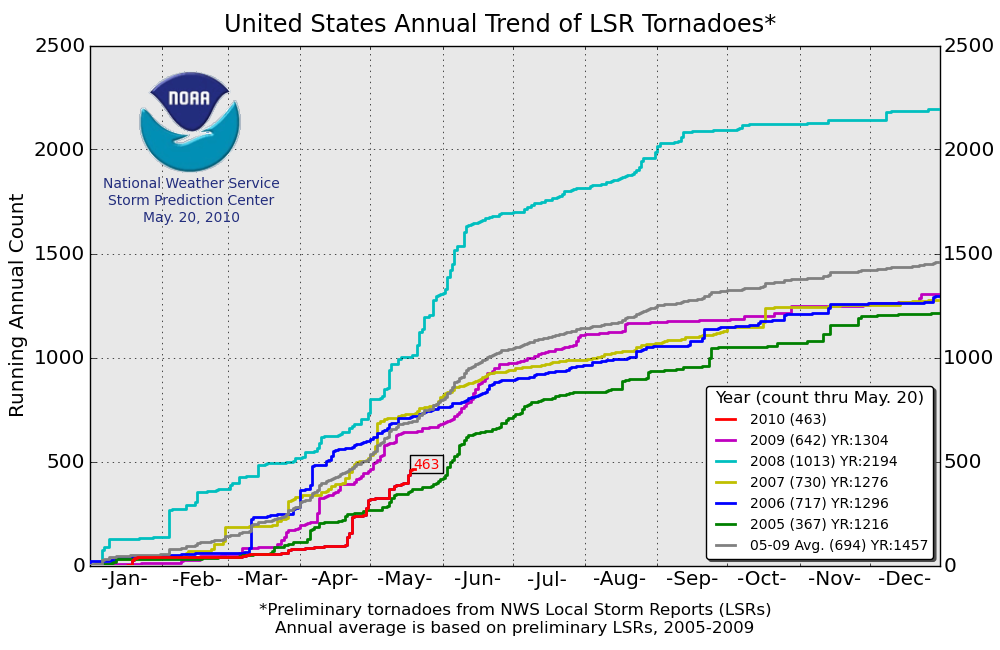
Just over a month ago, I posted on the unusual lack of tornadoes through mid-April. As expected, however, shortly after that post, there was an explosion in this year’s tornado count.
Here’s how we stand through Thursday, May 20 (does not include the 5 tornado reports from yesterday).

This graph (click to enlarge) from the Storm Prediction Center shows the trend in local storm reports (LSRs) of tornadoes in the U.S. LSR values may be slightly higher than the actual tornado count, as some tornadoes may have been reported more than once.
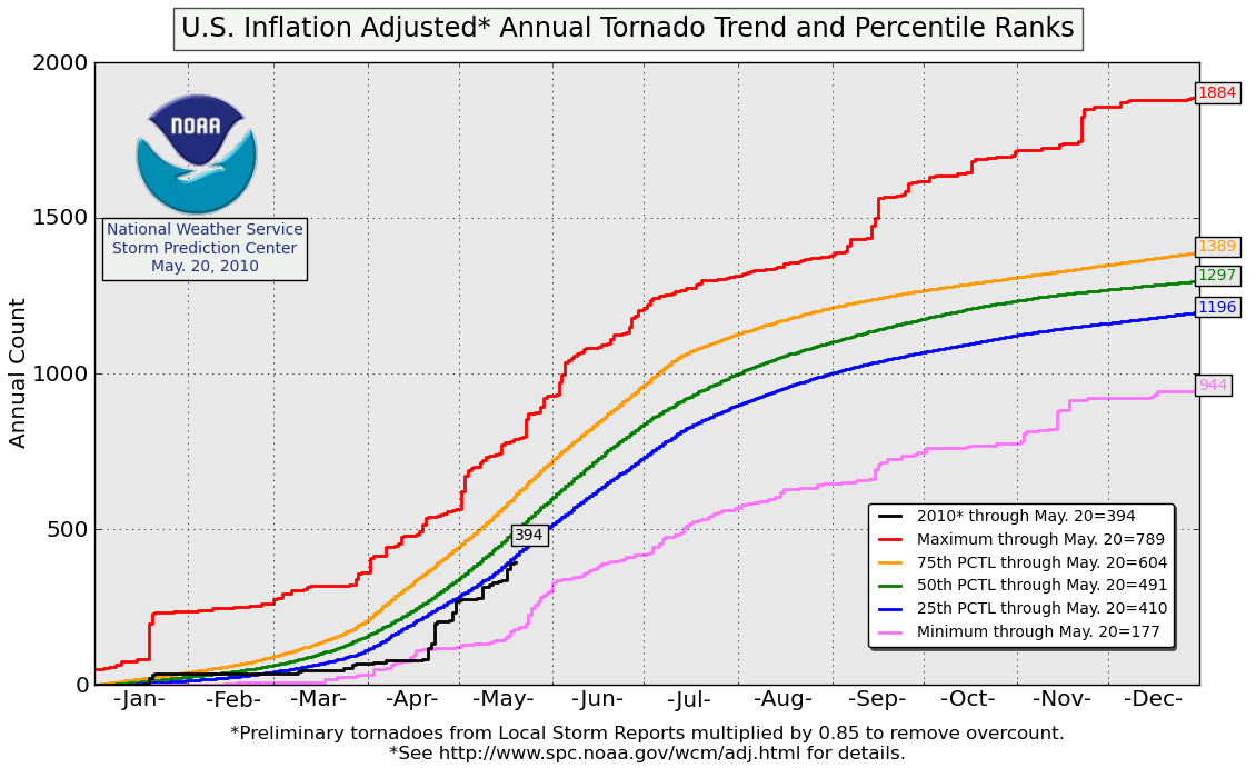
The next graph, also from the Storm Prediction Center, shows annual tornado trends and percentiles; calculation details are at the website at the bottom of the figure. The red line is the maximum tornado count in a single year and the pink line is the minimum tornado count in a single year. The other lines show tornado trends in quartiles.

Note that after briefly dropping below the all-time minimum, this year’s tornado count quickly jumped up in late April, and we’re now approaching the 25th percentile.
Although it looks like we’ll be getting a big ridge over the central US this coming week, inhibiting widespread severe storms for at least the next couple of weeks (though there are still likely to be localized areas with severe weather), the storm season is not over yet. There is usually a ridge that comes for a week or two in May, before another peak in tornado season comes in early or mid-June across the Central to Northern Plains.
Permalink
05.21.10
Posted in Uncategorized at 12:10 pm by Rebekah
I’ll starting working on chase logs for Tuesday and Wednesday later today, and will probably have those posted late tonight or tomorrow.
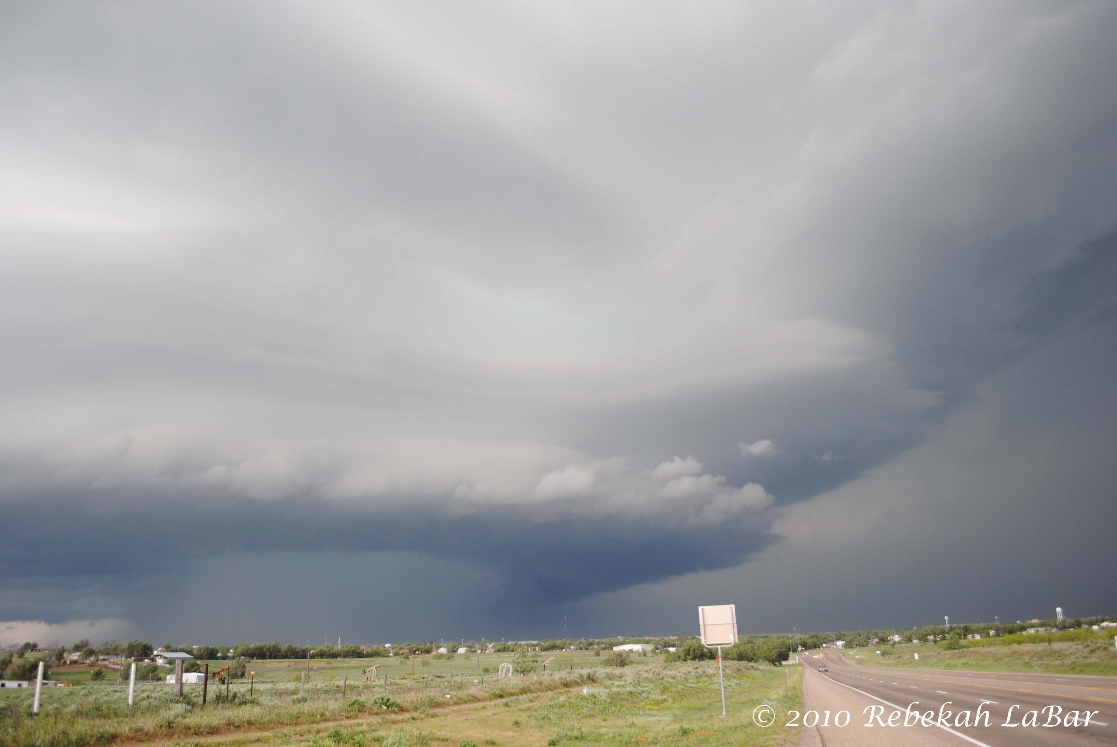
For now, here’s a photo (click to enlarge) of an amazing mesocyclone we saw northwest of Amarillo on Tuesday (just south of Stinett, where we caught a brief glimpse of a tornado). Note the big hail shaft and green sky in the center of the beast.

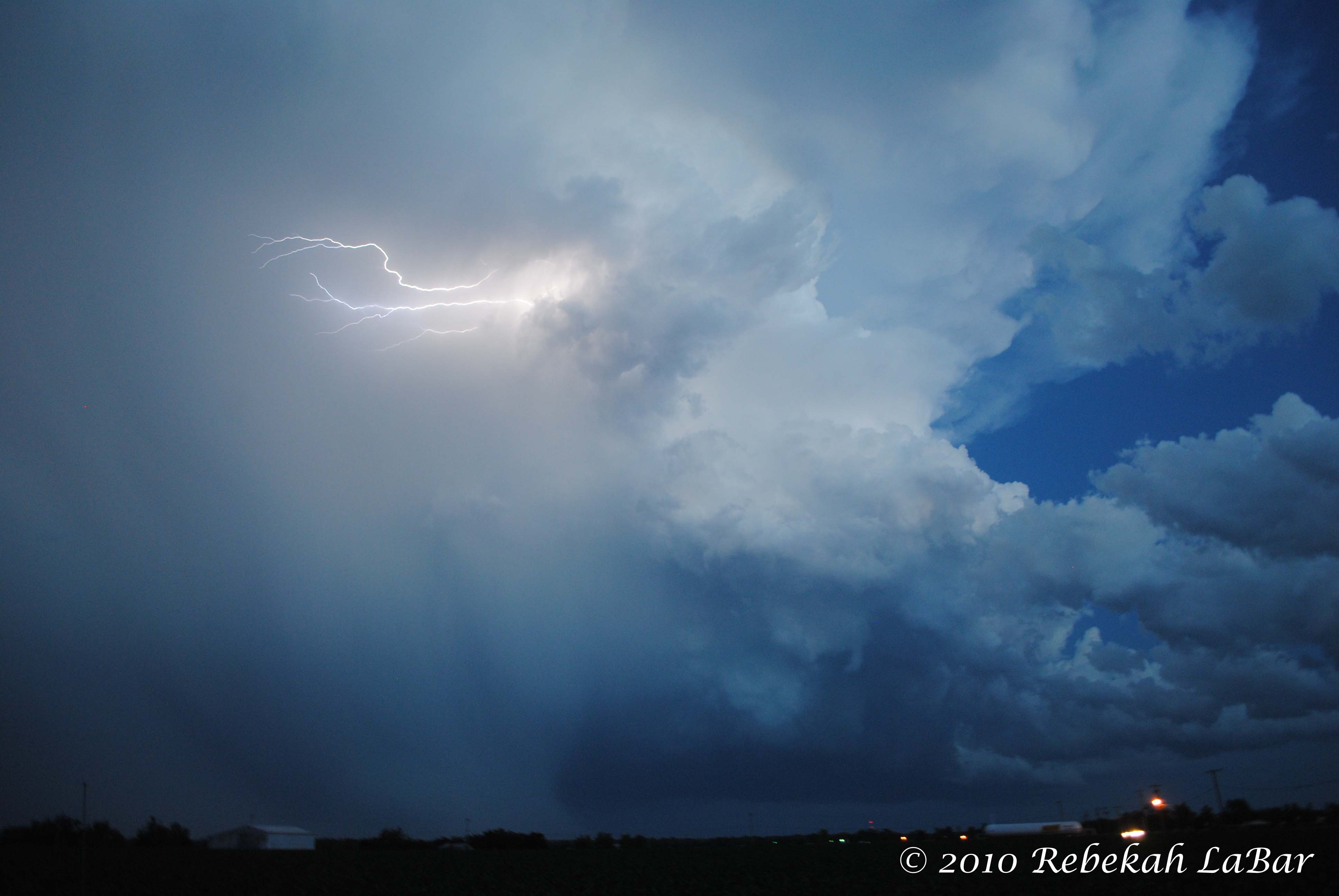
On Wednesday, we saw some amazing updrafts on several supercells around central Oklahoma, and a breath-taking lightning show!

More to come later…
Looks like things will start to calm down for at least the Southern Plains for now, giving me the much needed time to catch up on work and chase logs/photos. 🙂 The ridge that’s setting in will give Oklahoma some summer-like days for a while, so I’ve also got to get outside and enjoy this weather!
Permalink
« Previous entries Next Page » Next Page »
