05.19.10
Posted in Uncategorized at 11:54 am by Rebekah

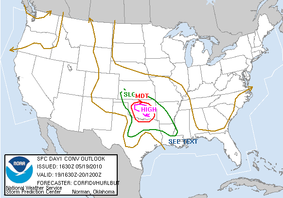
SPC just went high…rather eerily similar to May 10, though instability and shear should not prove to be as high.
Will keep a close eye on outflow boundaries from overnight MCS as well, and will try to get on supercells early, before they congeal into an MCS.
In OKC metro heading west on I-40 to Hobart, Oklahoma area for now. Should be streaming in about 30 minutes, after I get new amplifier up and running and new firewire cord hooked up with camcorder…
Permalink
Posted in Uncategorized at 10:32 am by Rebekah
Saw what appeared to be a brief tornado north of Stinett yesterday (never actually saw it on the ground, but it was extremely close to the ground and it was just over a hill, so likely was an actual tornado), after chasing a monstrous, breath-taking HP beast from its first moments as an updraft to well after dark, after it split and was producing a ton of lightning. But that’s for another post.
Today, conditions are somewhat similar, only improved. The low is setting up over the Texas Panhandle with a warm front expected to lift up through central Oklahoma and a dryline expected to tighten along the Texas Panhandle / Oklahoma border. Dewpoints ahead of the dryline should be in the mid- to upper 60s.
A trough over the Central Plains / Colorado / Wyoming will provide lift for storms to develop along the dryline, near the low, and along the warm front. CAPE is expected to reach 2000 to 3000 J/kg in Oklahoma ahead of the dryline, while there will not be much of a cap.
East/southeast winds near the surface will veer to southwest aloft, providing wind shear for supercells to form (NAM shows best helicity in east central Oklahoma).
Initiation should be early today, so we’ll be leaving in the next 30 minutes or so for probably the Clinton to Lawton area.
Permalink
05.18.10
Posted in Uncategorized at 11:09 am by Rebekah
Jeff and I are off to Amarillo today, in the hopes of seeing some supercells, lightning, hail, and possibly tornadoes.
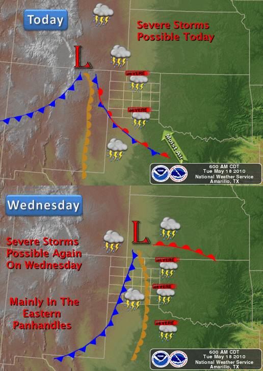
The SPC issued a moderate risk today for the Texas Panhandle. It looks to be a pretty classic dryline setup, with an elongated surface low forming in southeast Colorado / east New Mexico later today with a dryline extending south along the Texas / New Mexico border and a warm front lifting up through north Texas.
Dewpoints will be in the low to mid-60s in the Texas Panhandle with plenty of moisture convergence along the dryline. Southeasterly surface winds of 10 to 15 knots veering to west-southwesterly 500mb winds of 30 to 40 knots will provide ample vertical wind shear for rotating storms. I would like to see stronger upper-level winds, to improve speed shear, but perhaps the low-level jet will strengthen near evening and increase the shear.
Upper-level support will not be as strong as on Wednesday (I do plan on chasing tomorrow, too, as it looks even better, and will be closer to home)–but it certainly will be much better than forecast by the models last week. A trough is approaching the Four Corners region and both the NAM and the GFS hint at subtle shortwaves that may increase lift in the Texas Panhandle.
Instability also leaves something to be desired. Based on the NAM and the GFS, it looks like CAPE may reach 1500 to 2000 J/kg in the panhandle. Mid-level lapse rates, however, appear to be more than sufficient for large hail, especially considering the general lack of a strong cap.
Our hopes are not too high today for seeing a tornado, though I would not completely discount the possibility. I would tend to expect more LP to classic supercells with some nice structure and possibly large hail. It’s also great scenery out in the Texas Panhandle, so I’m sure we’ll have a good day regardless of what the weather does. =)
We’re currently just past Weatherford, Oklahoma, heading west on I-40 (Jeff’s driving to the target area, and I’ll take over from there…just so I don’t have to drive the entire day when it’s such a long way…).
We probably won’t be able to stream much today, as AT&T’s service isn’t very good in the panhandle. My cell phone signal booster will be arriving later today, so I can use that tomorrow, but it wouldn’t do any good anyway where there isn’t a signal to begin with.
Preliminary target: Amarillo, Texas, and perhaps some points west of there, from Dalhart to Dimmitt.

NWS Amarillo Forecast
Permalink
Posted in General News, Weather News at 8:52 am by Rebekah

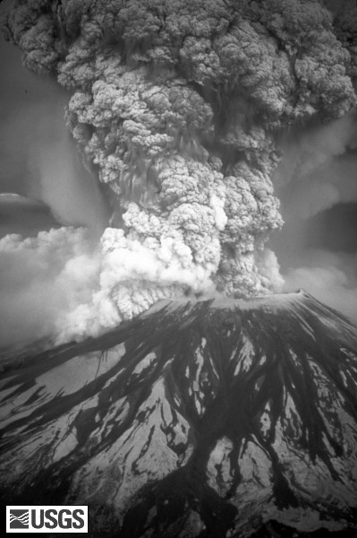
Today is the 30th anniversary of Mount St Helens’ catastrophic eruption.
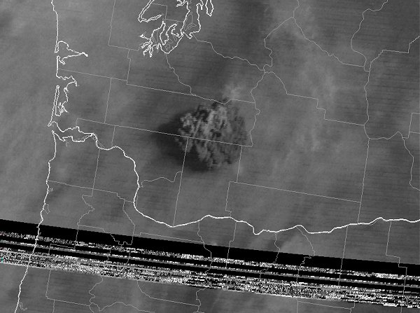
On May 18, 1980, the Washington State volcano shot ash 12 miles up into the atmosphere (see satellite image from GOES-3, below, taken at 8:45 am PDT, courtesy of Wikipedia). In about two weeks, the ash had circled the globe.

For more information on Mt St Helens’ eruption, see the Wikipedia article and the Mt St Helens website. The Mt St Helens volcano cam may be showing a commemoration event today.
Volcanoes can affect weather and climate; in some cases, volcanic eruptions have been associated with cooler temperatures (sulfuric acid can block some sunlight from reaching the Earth). It will be interesting to see if the recent eruptions of the Icelandic volcano Eyjallajökull have any effect on European temperatures in the near future.
Speaking of the Icelandic volcano, continued eruptions and northwest winds have prompted more flight cancellations in Europe recently. However, it appears that the upper-level winds are changing, and Europe should be okay for a little while again…
Permalink
05.17.10
Posted in Weather News at 9:40 pm by Rebekah

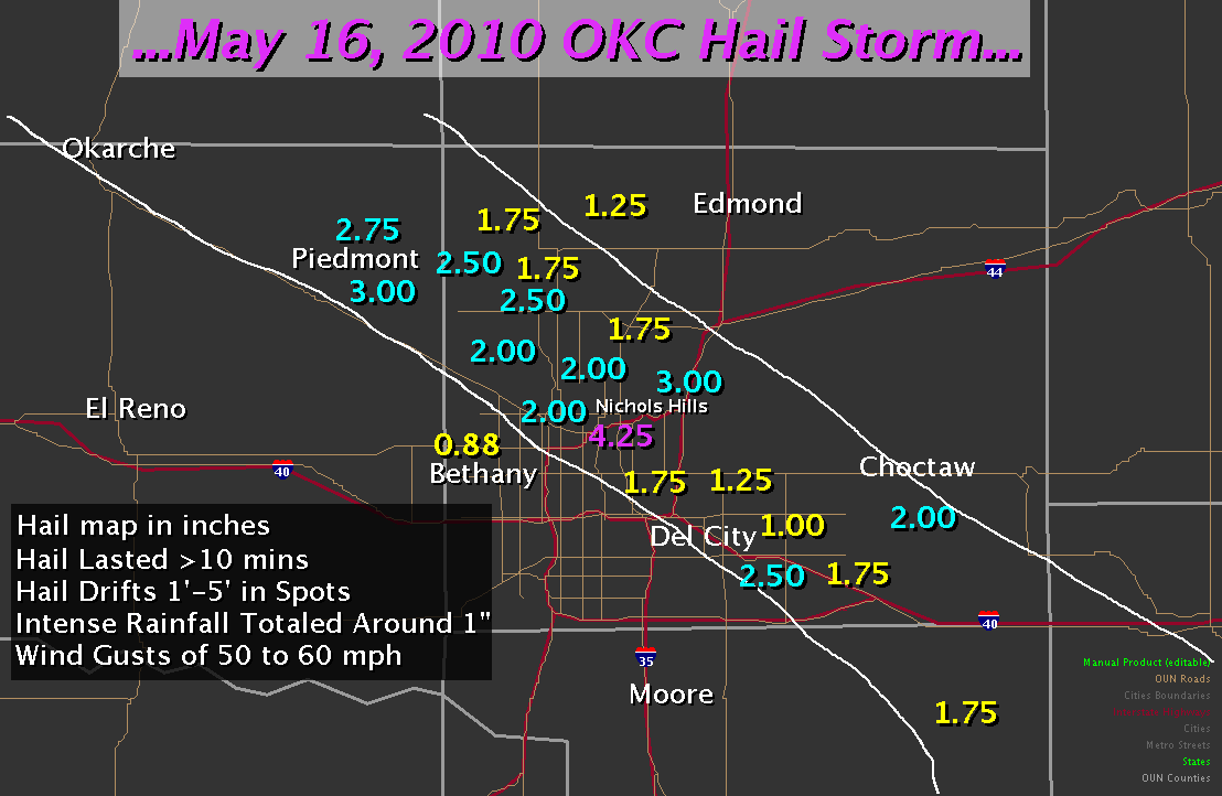
Here’s a map the NWS constructed of the hail swath through Oklahoma City yesterday.
We were just south of the 4.25″ report, near the one that shows 1.75″–though our hail was only 1″ at the very largest.
The NWS has more information on the storm setup and hailstorm on this website.
Permalink
« Previous Page — « Previous entries « Previous Page · Next Page » Next entries » — Next Page »
