06.30.10
Hurricane Alex
Last night, Alex became the first hurricane of the 2010 Atlantic hurricane season and the first June Atlantic hurricane in 15 years.
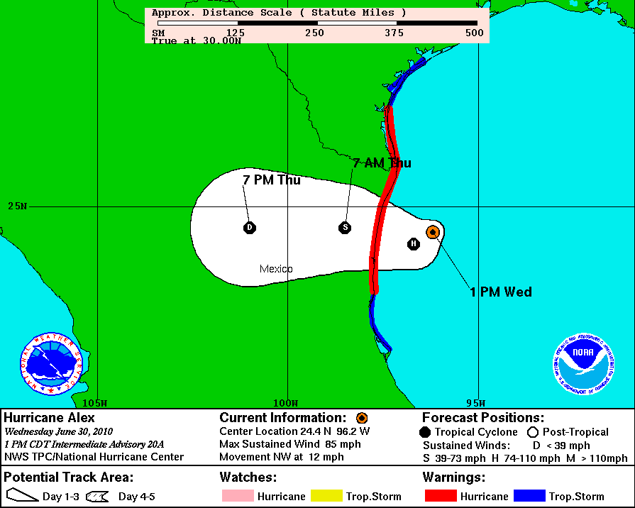
Alex is currently a Category 1 hurricane with maximum sustained winds of 85 mph and a minimum central pressure of 962 mb. Hurricane Alex is expected to make landfall late tonight as possibly a weak Category 2 (sustained winds of at least 96 mph) in far northeastern Mexico, just south of Brownsville at the Texas border.
Alex is a large tropical cyclone; hurricane-force winds (sustained of at least 74 mph) extend outward 60 miles from the core, while tropical storm-force winds (sustained of at least 39 mph) extend outward 200 miles from the core.
Threats from Alex include:
- Rainfall – 6 to 12 inches expected over northeastern Mexico and southern Texas, with isolated amounts of 20 inches
- Flash floods and mudslides – as a result of the heavy rain, especially in mountainous terrain
- Wind – tropical storm-force winds are already affecting the coast, and hurricane-force winds are expected to reach the coast within the hurricane warning area tonight
- Storm surge – 3 to 5 feet along the coast, north of where the core makes landfall
- Tornadoes – expected in the outer rainbands in southern Texas today and tonight
The right-front quadrant of a Northern Hemisphere tropical cyclone is always the most dangerous part to be, so even though Brownsville will not receive a direct hit from the eye, the rain, storm surge, winds, and tornadoes could be worse than in Mexico.
In the Northern Hemisphere, low pressure systems, including tropical cyclones, rotate counter-clockwise. Thus on the right side of a cyclone, with respect to its motion, winds will be stronger than on the left side, as the rotational speed combines with the forward speed (on the left side, the winds are weakest, as the direction of rotation is opposite from the direction of motion).
These stronger winds on the right side of a tropical cyclone additionally result in more water being pushed towards land, thus the storm surge will be the worst on the right front side (as it makes landfall).

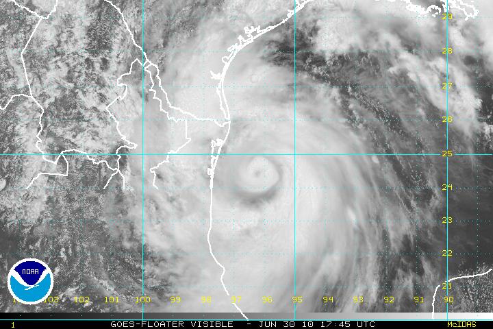
1745 UTC (12:45 pm local time) visible satellite image of Hurricane Alex, courtesy of the National Hurricane Center. An eye is starting to form, indicating strengthening.
A tornado watch was issued by the Storm Prediction Center this morning for southern Texas, and so far three tornadoes have already been reported around Brownsville, as the outer rainbands of Alex are already coming on shore. The outer rainbands are made up of multiple severe thunderstorms, so supercells are often found in this area if the wind shear is great enough (friction as the cyclone comes ashore contributes to greater wind shear).
Tropical cyclone tornadoes do not tend to be as strong as tornadoes of the Great Plains, largely because shear is not as high. Lightning, also, is not very prolific in tropical cyclones, partly because there is not as much ice above a warm-core system (ice is needed to create an electric field).
For the latest information on Hurricane Alex, check out the National Hurricane Center and the Brownsville National Weather Service!
