08.21.10
Norman Microburst
A microburst on the northeast side of Norman this evening left over 500 homes and businesses without power.
I received a trace of rain and heard a bit of thunder at my apartment on the north side of town, but looked at the radar and saw what I thought was just a small, weak thunderstorm. The wind blew a little bit, but only gusted to 32 mph at the airport.
On my way to a School of Meteorology get-together, I saw the road was blocked as a power pole was laying down in the road. Another power pole nearby was snapped about a third of the way up, and all of the traffic lights in that area were either not working or blinking red.
I noticed later that a local storm report for north Norman at 7 pm local time (CDT) read: “FROM 650-700PM NUMEROUS REPORTS OF DAMAGE BETWEEN 12TH AND 24TH BETWEEN ROBINSON AND ALAMEDA. 4 INCH DIAMETER LIMBS DOWN, POWER POLES SNAPPED, SHINGLES BLOWN OFF HOUSES.”
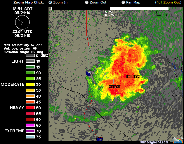
Here’s what the Oklahoma City TWDR (high-resolution radar) looked like at 6:51 pm CDT (from Weather Underground).
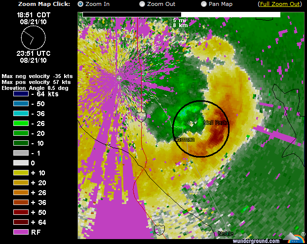
It doesn’t look like anything special, but now take a look at a base velocity image for the same time.
Note the area of orange and green between Norman and Hall Park (circled). This is a pretty classic microburst signature.
Negative numbers (green and blue colors) mean the wind is blowing towards the radar (location marked at the white “+” in the upper left), while positive numbers (yellow and orange) mean the wind is blowing away from the radar.
In this case, fairly strong winds are diverging over a small area between Norman and Hall Park. The radar estimates winds of 36 knots moving towards the radar and winds of 64 knots moving away from the radar, equating to 100 knots (115 mph) wind shear over about a 2 mile distance.
A microburst is a small column of rapidly descending air, which hits the ground and spreads out fast. A microburst is a type of downburst that occurs over a very localized area, defined as 2.5 miles in diameter or less. Microbursts/downbursts can occur as a thunderstorm is dying, and are capable of producing straight-line surface winds of over 150 mph.
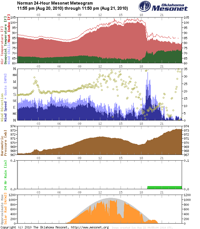
Finally, here’s a meteogram from the Norman mesonet station, showing how several meteorological parameters have changed over the last 24 hours.
Note several things (this station is near the airport, and not quite on the northeast side of Norman):
- rapid drop in temperature between 6 and 7 pm (when the storm rolled through)
- increase in dewpoint at the same time, when it began to rain
- increase in wind speed and fluctuations in wind direction
- pressure rise
Also, take a look at the solar radiation plot–the gray area shows the maximum amount of solar radiation that we could be receiving this day, while the orange area shows the amount of solar radiation we actually did receive.
The orange area dips down whenever clouds pass over, and goes back up when it gets sunnier. Now note what happened just as the sun went down–the actual solar radiation was HIGHER than the maximum possible solar radiation! What’s up with that?
As I went out tonight, I saw everything bathed in orange. The sun was just going down, but the storm was to my southeast and the anvil was covering the sky. The sun was on the horizon, so the low beams of the sun bounced off the clouds just right and back towards earth, providing us with more solar radiation than we would have otherwise received.


