08.10.10
Posted in Non-US Weather, Weather News at 5:02 pm by Rebekah
This week’s post in the global weather and climate series features Puerto Ayora, in the Galápagos Islands.
-
-
-
-
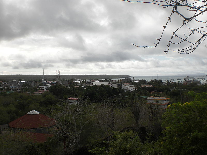
Puerto Ayora skyline. Courtesy of Wikipedia.
The Galápagos Islands are an archipelago of 18 volcanic islands that are governed by the country of Ecuador, located about 600 miles to the east. Situated on and near the equator, the Galápagos Islands are known for their wide variety of animals. The islands were discovered by the Spanish in the early 16th century, but until the early 19th century, they were frequently used as hideouts by English pirates who preyed on Spanish ships carrying riches from South America to Spain. The Galápagos Islands are also famous for being the study area of Charles Darwin, who sailed there on the HMS Beagle in 1835.
On the southeastern coast of Santa Cruz Island, Puerto Ayora is the largest city in the Galápagos Islands. Puerto Ayora is home to about 18,000 people (there are about 23,000 in the entire island chain) as well as the Charles Darwin Research Station, a biological research station focused on conservation of the Galápagos Islands’ terrestrial and marine ecosystems.
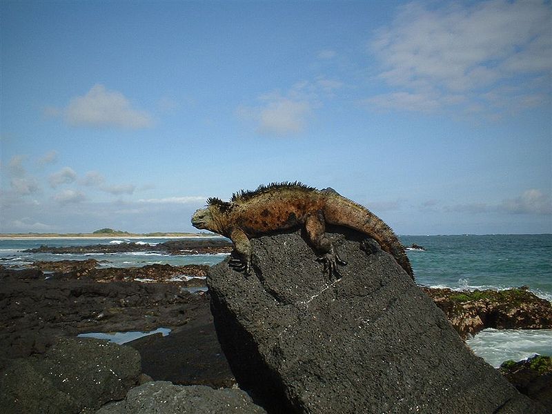
Marine iguana in the Galápagos Islands. Courtesy of Wikipedia.
A few more facts about Puerto Ayara (weather data from Eos Ecuador, averaged over the islands):
- Time zone: Galápagos Time (UTC-6)
- Elevation: 0 to 52 ft above mean sea level
- Climate zone: Tropical
- Average high temperature: 80 °F (27 °C)
- Average low temperature: 68 °F (20 °C)
- Average annual precipitation: 9 inches (230 mm)
Weather in the Galápagos Islands is warmer and wetter from January to June and cooler and drier from July to December. During El Niño, temperatures are warmer and rainfall is greater, while during La Niña, temperatures are cooler and rainfall is less.
Temperatures do not vary much on the islands, especially on the coastlines.
Current weather: Puerto Ayora is currently in the dry season, when any precipitation that does fall is generally in the form of drizzle. This week, Weather Underground is forecasting high temperatures from 69 to 71 °F and lows from 66 to 68 °F (not much variability, as the temperatures are primarily governed by the water temperature). Skies will usually be clear, with the exception of Wednesday and Friday, when there is a 20% chance for trace amounts of rain.
For more information on Puerto Ayora, here’s a link to Wikipedia. For more information on the Galápagos Islands, here’s another link to Wikipedia.
For weather maps and information on current and forecast Galápagos Islands and Ecuadorian weather, see the Instituto Nacional de Meteorología e Hidrología (Ecuador’s national weather service, in Spanish) and Weather Online UK (collection of maps and weather information for all over the world).
Next Tuesday I plan to take a look at the climate and weather in another part of the globe. As always, if you have any comments or suggestions for future cities, please leave a comment on this post!
Permalink
08.08.10
Posted in General News at 6:19 pm by Rebekah
EDIT: A 5-minute sample of my HD Campo video has just been posted to YouTube – check it out!
———————————————————————————————————-
I’ve finally posted the long-awaited (well, at least by me!) chase log and photos from the Campo, Colorado tornado day. I took over 500 photos this day, so it was difficult to narrow down the selection to some of the best of the best.
Enjoy!
http://www.greenskychaser.com/chasing/2010/may31.htm
Permalink
08.05.10
Posted in Tropical Weather, Weather News at 8:43 pm by Rebekah
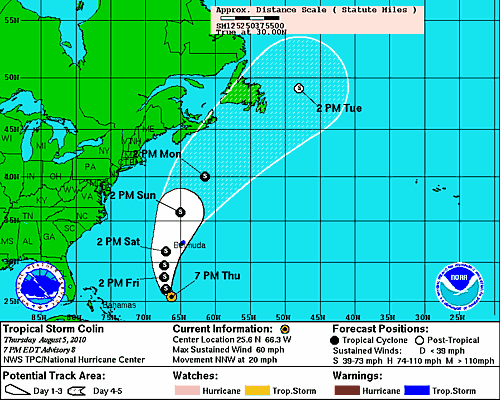
Tropical Storm Colin is back!
Wind shear decreased enough across Colin’s path for the system to re-intensify. Aside from the Bermuda Triangle, ships, and some fish, Colin presents no immediate threat.
Permalink
08.04.10
Posted in Tropical Weather, Weather News at 3:41 pm by Rebekah
It’s hot.
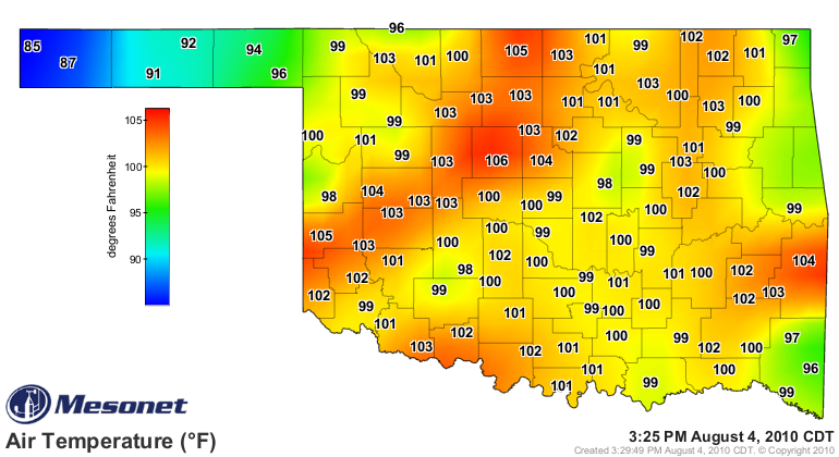
We do have the possibility for a few passing showers and thunderstorms with the passage of a “cold” front tonight into tomorrow…but this is what the NWS Norman has to say about the temperatures behind the front:
“Although the temperatures will be a little cooler behind the front, moisture will increase and keep heat indices elevated. Therefore, we are not expecting significant relief from the heat.”
In other news, Tropical Storm Colin only lasted a few hours yesterday before degenerating into an open trough. As the system will be passing under an upper-level low with plenty of wind shear, regeneration is not likely. However, the National Hurricane Center seems to think it’s not entirely out of the question, given a few days for the shear to decrease.
The next name on the storms name list is Danielle. However, if a new tropical storm forms from the same trough that Colin was a part of, the cyclone will likely retain the same name. This happened in 2004, when Hurricane Ivan hit the Gulf Coast, curved clockwise back to sea as a low, and made it back into the Gulf, where the original low restrengthened and regained tropical characteristics, becoming Ivan once again.
Permalink
08.03.10
Posted in Non-US Weather, Weather News at 2:26 pm by Rebekah
This week’s post in the global weather and climate series features Peshawar, Pakistan.
-
-
-
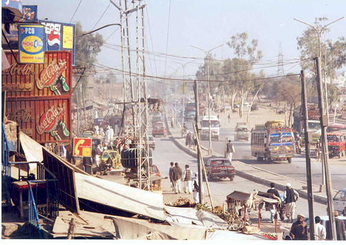
Karkhano Market in Peshawar, Pakistan. Courtesy of Wikipedia.
Historically part of the old Silk Road, Peshawar is located on a floodplain on the Iranian plateau, near the eastern end of the Khyber Pass and near the Kabul River. Peshawar is in northwest Pakistan, about 30 miles east of the Afghan border and 100 miles west-northwest of Islamabad. One of the oldest cities in Asia, Peshawar has a long and rich history, as it has existed in some form for over 2000 years. Peshawar is the capital of the Khyber Pakhtunkhwa province in Pakistan and is home to about 3.1 million people.
A few more facts about Peshawar (from Wikipedia):
- Time zone: Pakistan Standard Time (UTC+5)
- Elevation: 1,673 ft above mean sea level
- Climate zone: Semi arid (very hot summers and mild winters)
- Average high temperature: 104 °F (40 °C)
- Average low temperature: 39 °F (4 °C)
- Average annual precipitation: 16 inches (400 mm)
Current weather: Pakistan is currently in the midst of a brutal monsoon season, with numerous floods affecting millions of people. Many people have lost their homes and up to 1,500 people have died as a result of the floods. Peshawar is not in a monsoon region, but the area around this city has recently received record rainfall that has caused rivers to swell and flood the plains.
The following satellite image shows clouds, largely as a result of the Indian monsoon, sweeping up over Pakistan (highest cloud tops are in blues and purples; orange indicates no or very low clouds).
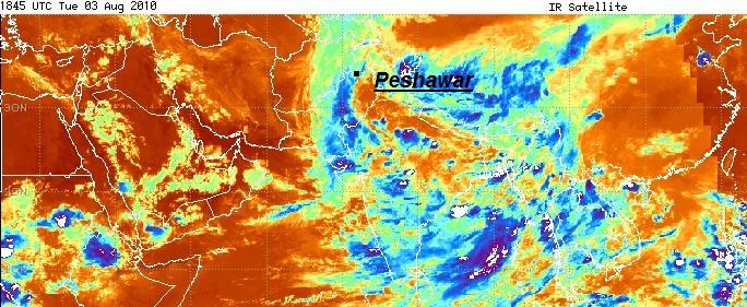
Infrared satellite image at 1845 UTC, showing Peshawar under clouds (click to enlarge). Satellite image from the Pakistan Meteorological Department.
Unfortunately, not much relief is in sight, as showers and thunderstorms are in the forecast for Peshawar all through this week into at least early next week. According to Weather Underground, Peshawar’s highs are expected to be in the low 100s and lows in the low 80s. The temperature on Friday is forecast to reach 109 °F, with a heat index of 114 °F.
For more information on Peshawar, here’s a link to Wikipedia.
For weather maps and information on current and forecast Pakistani weather, see the Pakistan Meteorological Department (Pakistan’s national weather service – it is in English!) and Weather Online UK (collection of maps and weather information for all over the world).
Next Tuesday I plan to take a look at the climate and weather in another part of the globe. As always, if you have any comments or suggestions for future cities, please leave a comment on this post!
Permalink
« Previous Page — « Previous entries « Previous Page · Next Page » Next entries » — Next Page »


