09.09.10
Posted in Weather News at 2:47 pm by Rebekah
Jeff and I went chasing in north Texas yesterday, with limited success.
In short, we first headed down to the Red River area, with low expectations. Neither of us had chased storms associated with a tropical system before, so we were not sure just what to look for. By the time we got to the Texas border, we had heard that there was a tornado near Colbert in southern Oklahoma. The storm that produced that tornado did not look like a tornado-producing storm, so we would not have known to go after it.
We got on a disorganized storm east of Denton, but it was difficult to tell what was going on as everything looked so messy. We soon saw there was a tornado-warned storm southeast of Dallas, and dove south. By the time we got there, the storm had produced a couple of tornadoes and there was another tornado-warned storm in downtown Dallas. This latter storm went on to produce at least one tornado, which has been rated EF2.
The Dallas storms actually had hook echoes and looked more like supercells. As we approached the downtown Dallas storm, we heard the tornado sirens go off…but by the time we got close enough, the storm had started to disintegrate.
On our way back north, we heard that there was a tornado spotted near Lindsay, near Gainesville (just south of the Oklahoma border). Again, the storm that produced this tornado did not look very well-organized.
I could not be very disappointed, as it was a difficult day due to the storms not being classic Plains supercells and to not being quite sure how to target storms associated with a tropical cyclone. I did learn a bit from it, though, and it was nice to just get out on the road again.
Today there could be some severe weather up in the Northern Plains. Tomorrow also looks like it could get interesting in eastern Kansas / western Missouri. Biggest problem at present appears to be weak low-level winds, in contrast to yesterday, when the low-level winds were quite high. Might go up to eastern Kansas, if it looks favorable enough by tomorrow morning…
Permalink
09.08.10
Posted in Tropical Weather, Weather News at 11:35 am by Rebekah
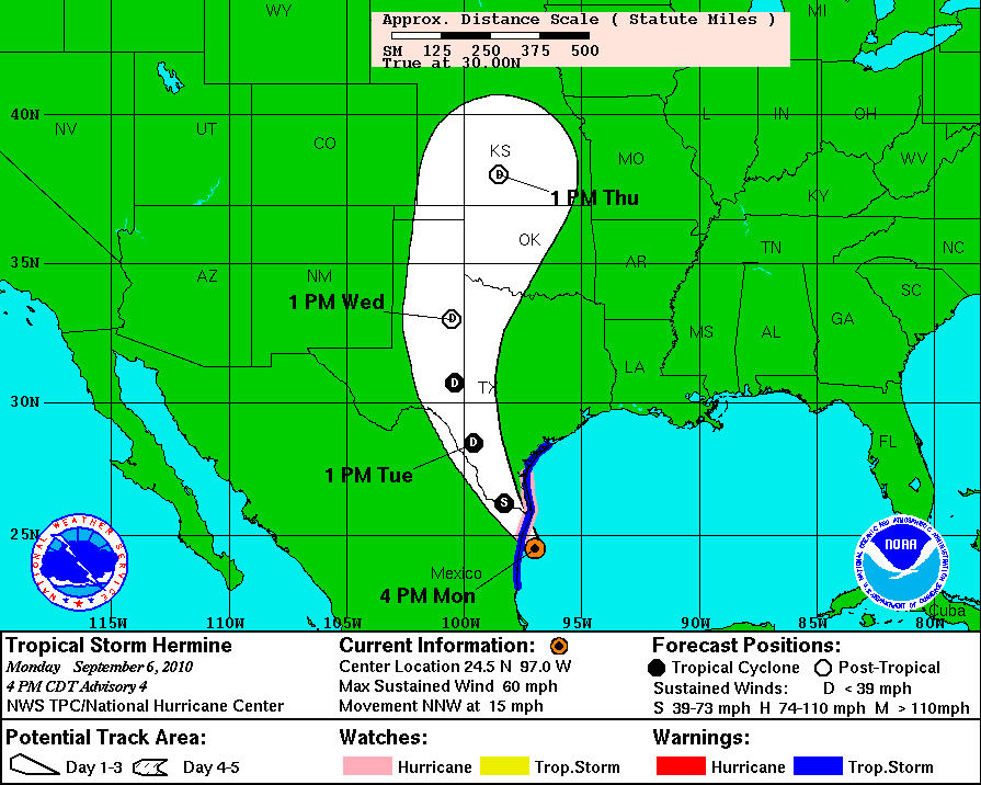
The rain from Tropical Depression Hermine made it up to Oklahoma this morning. Yesterday, Hermine began to cause some major flooding problems in Texas, and the rain is still coming down in some parts of Texas.
At the moment, Norman is experiencing a lull, as we’re in between a couple of the rain bands. However, we’re expected to get much more rain by tomorrow morning.
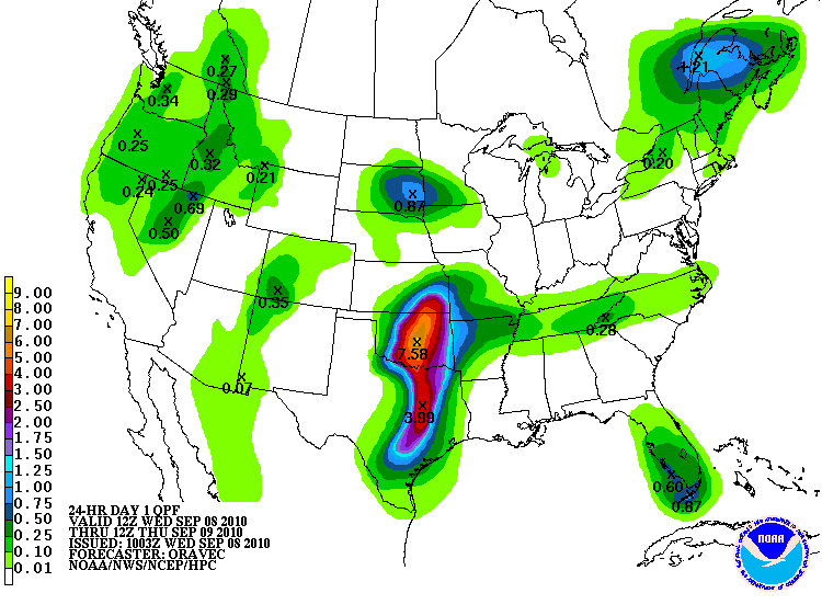
Here’s a look at the Hydrometeorological Prediction Center’s (HPC) rainfall forecast.

Yes, that’s right, 7.58 inches of rain forecast for central Oklahoma from this morning through tomorrow morning! According to the Oklahoma Mesonet, only 0.23 inches of rain has fallen so far in Norman (since midnight). Southern Oklahoma has already received almost 3 inches of rain.
But that’s not all Hermine may bring…the Storm Prediction Center (SPC) has a 5% risk out today for tornadoes from central Oklahoma down into north central Texas. Shear profiles are very favorable for supercells and tornadoes, thanks to Hermine, so the biggest problem will be instability. The SPC believes the greatest threat for supercells and tornadoes is in northern Texas, as that’s where the greater instability is likely to be. Tropical tornadoes tend to be difficult to see (wrapped up in all the rain) and predict (not coming from a traditional Plains supercell). However, these tornadoes are often quite weak (EF2 or less).
I’ve never chased a tropical system or tropical tornadoes before, but I am considering going out this afternoon to give it a try. I’ll give another look at some weather maps and decide this shortly.
In other news, Tropical Storm Igor (9th named storm so far) formed in the far eastern Atlantic this morning. It appears that Igor will become a hurricane in a few days, and possibly a major hurricane. However, Igor will likely recurve before it gets close to land. Models show that Tropical Storm Julia may also form in the next few days.
The 9th Atlantic tropical storm typically forms around October 4th, so we are already a month ahead of schedule, in what the NHC and Colorado State predicted would be an above average year for Atlantic tropical activity…
Permalink
09.07.10
Posted in Non-US Weather, Weather News at 6:43 pm by Rebekah
This week’s post in the global weather and climate series features Christchurch, New Zealand.

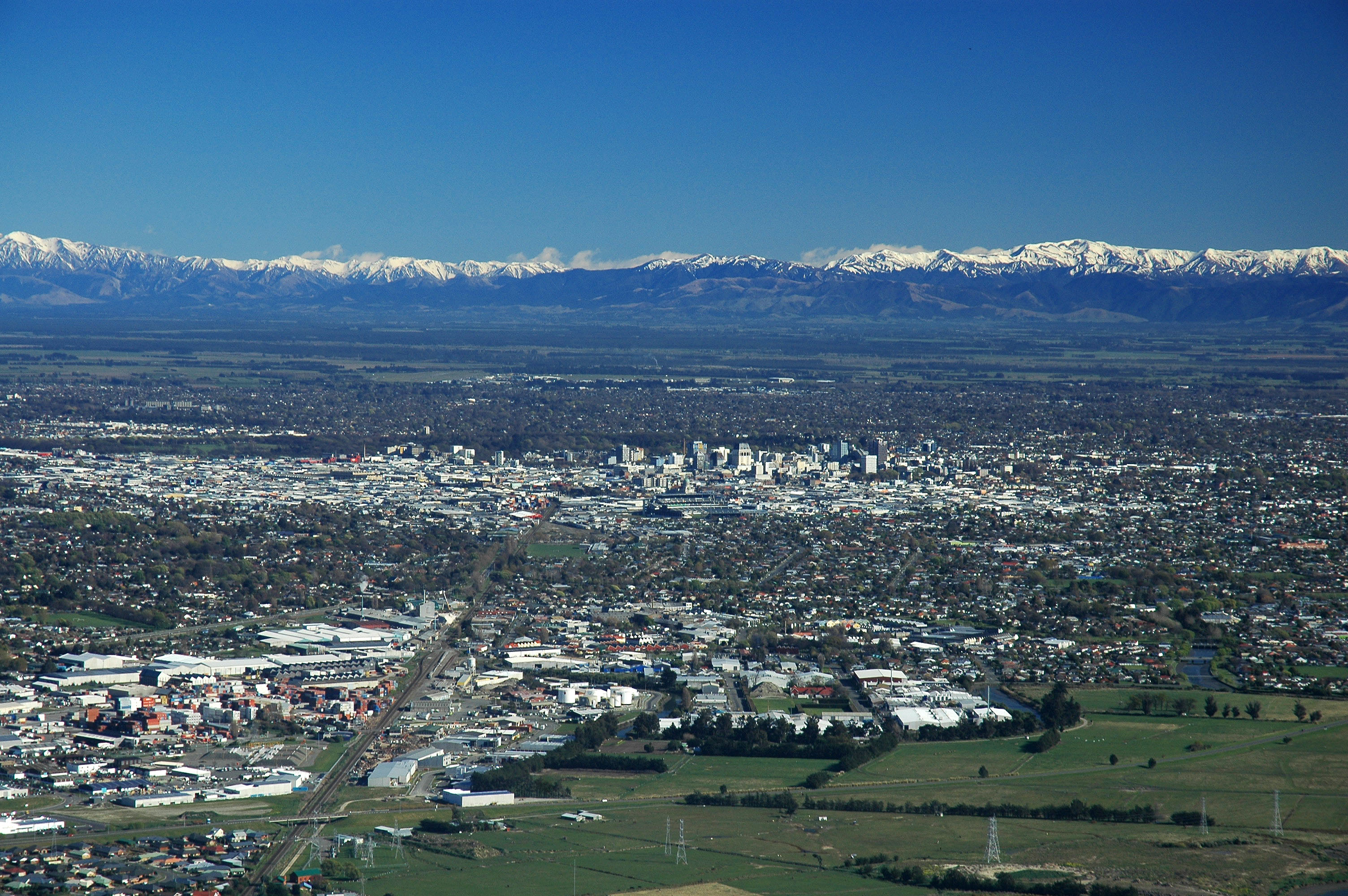
Christchurch City, New Zealand, from the Port Hills. The Southern Alps are in the distance. Courtesy of Wikipedia. Click to enlarge.
Christchurch, in the region of Canterbury, lies about 1/3 of the way down the southeast coast of New Zealand’s South Island (43.5 °S, 172.5 °E). New Zealand is about 1,200 miles southeast of Australia. Bordered by rivers, the Canterbury Plains, the Port Hills (a volcanic mountain range), and the Pacific Ocean, Christchurch, with a population of 386,000, is the second largest city in New Zealand, after Auckland (pop. 1.3 million), on the North Island.
Christchurch has one of the highest quality water supplies in the world. This water comes from aquifers in the Southern Alps, a mountain range that runs northeast to southwest across the South Island. The pristine scenery of New Zealand has served as the backdrop for several movies, including The Lord of the Rings trilogy and The Chronicle of Narnia: the Lion, the Witch, and the Wardrobe.
The United States uses Christchurch International Airport as the takeoff point for the main supply route to McMurdo and Scott Bases in Antarctica.
On Saturday, 4 September 2010, a 7.1 magnitude earthquake struck about 25 miles west of the center of Christchurch, causing about $2 billion NZD in damage (about $1.5 billion USD).

Abel Tasman National Park, on the northern end of the South Island of New Zealand. Courtesy of Wikipedia.
A few more facts about Christchurch (from Wikipedia):
- Time zone: New Zealand Standard Time (UTC+12) or New Zealand Daylight Time (UTC+13)
- Elevation: 0 to 3,018 feet
- Climate zone: Temperate, dry (also oceanic)
- Average high temperature: 63 °F (17 °C)
- Average low temperature: 45 °F (7 °C)
- Record high temperature: 107 °F (42 °C)
- Average annual precipitation: 25.5 inches (648 mm)
- Snowfall: occurs on average once or twice a year in the hills, and once or twice every two years in the plains

Aoraki/Mount Cook, the highest mountain in New Zealand (12,316 ft). Located in the Southern Alps west of Christchurch. Courtesy of Wikipedia.
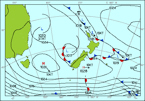
Current weather: It is late winter in Christchurch, so temperatures are cooler and the weather is wetter. Christchurch is currently under a high pressure system, which spins counter-clockwise in the Southern Hemisphere. This is bringing the city easterly winds, which are responsible in part for the rainy weather.
Lows this week are in the lower 40s and highs are in the mid- to upper 50s. Christchurch is expecting rain/drizzle all week.

Surface weather analysis for New Zealand today. Courtesy of the Meteorological Service New Zealand Limited.
Occasionally tropical cyclones approach New Zealand, during the Southern Hemisphere summer months (December – April), but by the time they reach that latitude, they are usually weaker and have lost some of their tropical characteristics.

Pancake Rocks, Paparoa National Park, on the west coast of the South Island of New Zealand (northwest of Christchurch). Courtesy of Wikipedia.
For weather maps and information on current and forecast Christchurch and New Zealand weather, see the Meteorological Service of New Zealand Limited (New Zealand’s weather service), Weather Zone (Australia’s leading commercial weather information provider), and Weather Underground.
For more information on Christchurch, here’s a link to Wikipedia. For information on New Zealand, here’s another link to Wikipedia.
Next Tuesday I plan to take a look at the climate and weather in another part of the globe. As always, if you have any comments or suggestions for future cities, please leave a comment on this post!
Permalink
09.06.10
Posted in Tropical Weather, Weather News at 3:51 pm by Rebekah
The 8th named storm of the Atlantic hurricane season formed early this morning, Tropical Storm Hermine. Hermine will make landfall near Brownsville, Texas late tonight.
Hermine will then degenerate into a depression and travel up through Oklahoma. This will just mean more rain and thunderstorms on the way soon for Texas and Oklahoma.

Permalink
09.03.10
Posted in Weather News at 4:46 pm by Rebekah
Today let’s take a very brief look at what the weather’s doing around the country.
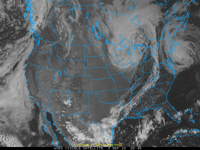
Visible satellite image from today, at 4:45 pm EDT, courtesy of College of DuPage:

You can see Category 1 Hurricane Earl off the New England coast, a low pressure system bringing clouds and rain to the Midwest, and clouds along a front from New York to Texas.
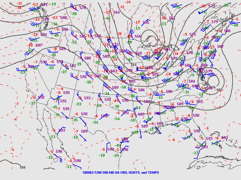
500-mb map from this morning, from the SPC:

Note the ridge over the West, bringing clear skies. The trough over the Midwest is associated with the low, and you can also see Hurricane Earl at this level. This trough is what’s going to push Earl back towards the East, although he may recurve a bit back up into Canada.
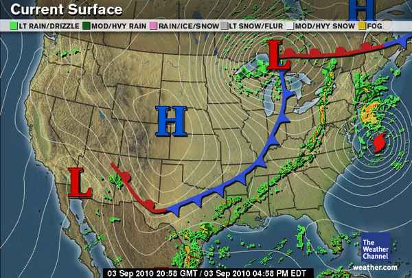
Surface map, from The Weather Channel, from 5pm EDT:

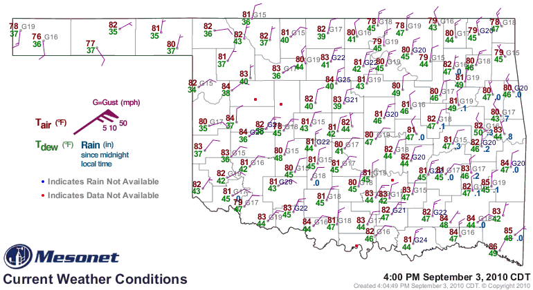
Here you can see the low pressure, high pressure, Earl, and the cold front. This cold front moved through Oklahoma last night, finally bringing us some much needed thunderstorms and cooler weather. Today has been very pleasant. See the surface map below, from 5pm EDT / 4pm CDT, from the Oklahoma Mesonet:

Permalink
« Previous Page — « Previous entries « Previous Page · Next Page » Next entries » — Next Page »
