10.26.10
World Wide Weather #21: International Falls, Minnesota
Series note: from here on out, I will skip Antarctica in the World Wide Weather continental rotation. Occasionally we may return there, but for now, we’ll rotate through just the other 6 continents.
This week’s post in the global weather and climate series features International Falls, Minnesota.
There is currently a very strong extratropical cyclone centered just north of International Falls, so we’ll be taking a brief look at that today.
International Falls is located in northern Minnesota, just across the Rainy River from Lake Frances, Ontario, Canada. The city is officially known as the “Icebox of the Nation”, following a 2008 trademark lawsuit with Fraser, Colorado. International Falls receives bitterly cold and snowy winters, but humid and hot summers. Settlers first arrived in the area in the 1600s, but the city did not become incorporated until 1909. The population (census 2000) of International Falls is 6,703.
A few more facts about International Falls (from Wikipedia):
- Time zone: Central Standard Time (UTC-6) or Central Daylight Time (UTC-5)
- Elevation: 1,122 feet
- Climate zone: Humid continental
- Average high temperature: 49 °F (9 °C)
- Average low temperature: 26 °F (-3 °C)
- Record high temperature: 103 °F (39 °C)
- Record low temperature: -55 °F (-48 °C)
- Average annual precipitation: 24 inches (608 mm)
- Average annual snowfall: 68 inches (173 cm)
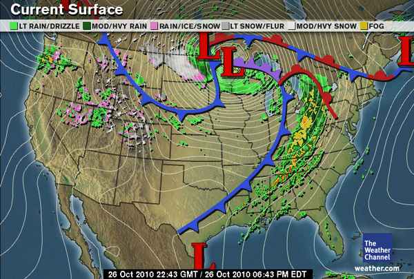
Current weather: Focusing on the record-breaking low-pressure system affecting International Falls, here’s the latest surface map from The Weather Channel, as of 5:43 pm CDT (click to enlarge):
As you can see, there is a large low-pressure system centered just north of the Canadian border, with a very tight pressure gradient (the lines on the map are isobars, lines of equal pressure).
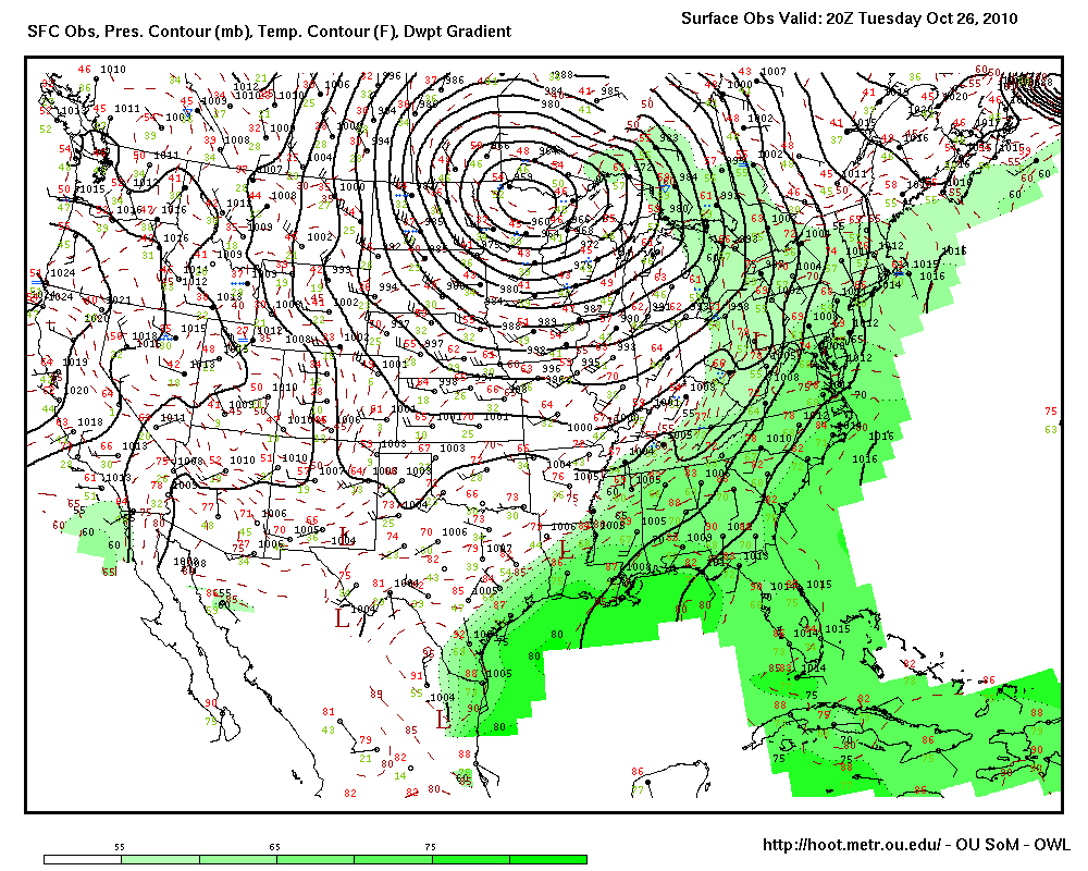
Now here’s another surface map, showing actual observations, from the Oklahoma Weather Lab from 3 hours ago, at 3 pm CDT (the more recent one has a slightly lower pressure, but the contours ended at the border):
Note how the contours are so close together. Note also the low pressure–on this map, the pressure at International Falls was 959 mb! Actually, this extratropical cyclone set new minimum, non-tropical pressure records in Minnesota and Wisconsin as well as the US as a whole. So aside from landfalling hurricanes, this system brought the lowest pressure ever recorded over the US mainland: 956 mb! This is the equivalent pressure of about a Category 3 hurricane!
The pressure is so low, and the pressure gradient is so tight, the winds around the low are very strong. There have been some gusts to well over 60 mph in the Upper Midwest.
Today has also been an active severe weather day, as storms have formed all along a cold front as well as out ahead of the cold front, producing high winds and tornadoes.
As I mentioned yesterday, if the air behind this system was just a little colder, there would be the potential for a major blizzard over the Northern Plains. As it is, there is some snow falling (see the Weather Channel map, above), but not enough for a big blizzard.
For weather maps and information on current and forecast International Falls weather, see the National Weather Service and Weather Underground.
For more information on International Falls, here’s a link to Wikipedia and here’s a link to the city’s webpage.
Next Tuesday I plan to take a look at the climate and weather in another part of the globe. As always, if you have any comments or suggestions for future cities, please leave a comment!


