10.14.10
Posted in Weather News at 2:46 pm by Rebekah
Models over the last week have consistently been showing a nor’easter developing at the end of this week.
A nor’easter is a strong extratropical cyclone that forms off the New England coast, bringing strong northeast winds into New England. These storm systems are most often associated with wintry conditions.
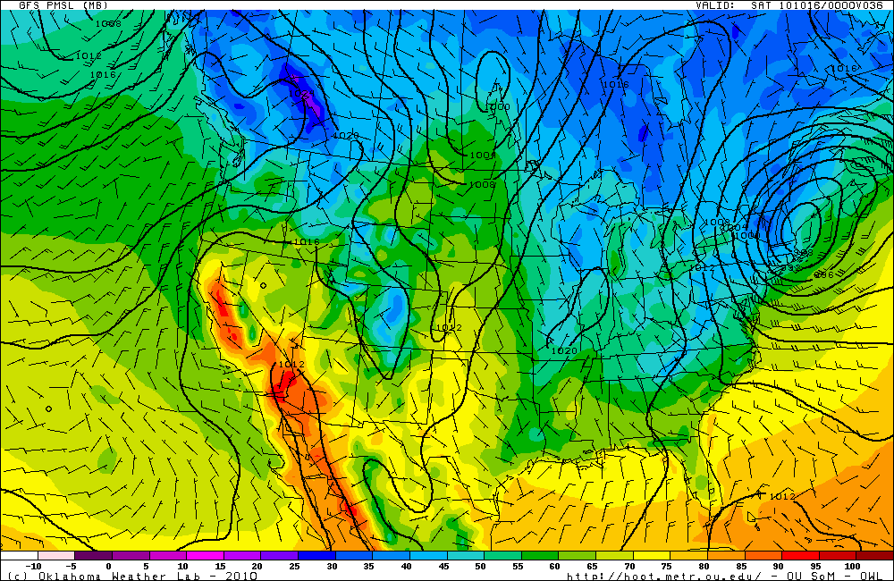
Here’s what the GFS model shows in terms of the location and depth of the nor’easter (this map is valid for 00Z Saturday, or 8pm EDT Friday; click to enlarge):

This surface map, courtesy of the Oklahoma Weather Lab, shows a 988 mb low (fairly low pressure for this time of year) centered over southern Maine. The lines represent surface pressure, and the colors represent surface temperature. Temperatures at this time are forecast to be in the 30s in northeastern New York, Vermont, western New Hampshire, and northwestern Massachusetts.
The most likely scenario is for there to be some snow in the mountains of Vermont and New Hampshire tomorrow night, with cold rain and the possibility for flooding over much of the rest of New England.
It’s probably a good thing that the American League Championship Series starts in Texas tomorrow night. I can’t cheer for the Rangers and Cliff Lee, especially after the Rangers got Lee from the Mariners this year. So GO YANKEES!!
Permalink
10.13.10
Posted in General News at 10:55 am by Rebekah
At 9:06 am, I was upstairs in my 2-story apartment, about to leave for class, when I heard a giant rumble and felt the whole building shake.
Not having lived in earthquake country for a few years, I was confused for a minute at what that was. My cat just ran into the hall, crouched down low and stared at the door, as if he was expecting some elephant to walk in the door. My neighbors started yelling and I stepped outside to see what was going on. “Earthquake!” someone smiled. “I’m just talking to my wife and she says they felt it in Moore!” one man called out.
I saw that on facebook and twitter, everyone around Norman was talking about the earthquake. People have now reported feeling it as far away as Wichita, Kansas and Dallas, Texas.
The USGS initially reported the earthquake as a 4.5, but since then they’ve updated the information to a 4.3 magnitude quake, centered 6 miles ESE of Norman, and 3.1 miles deep.
The last earthquake I remember feeling was a strong 6.8 quake that lasted a minute, when I lived back in Ellensburg, Washington. That one was centered near Olympia, on the west side, but we felt it on the east side and even the high school was damaged and had to be rebuilt. The quake lasted for a minute, unlike the one this morning, which only lasted for probably 15 or so seconds.
The campus is abuzz with talk of the earthquake…everyone has their story of where they were and what they felt, or a story of how they didn’t feel it because they were sleeping or driving.
What a crazy way to start the day!
USGS link to the information on the quake…it may be updated if more information becomes available:
http://earthquake.usgs.gov/earthquakes/recenteqsus/Quakes/us2010ciay.php
UPDATE @ 11:30am CDT: USGS now says depth was 4.9 miles, and the epicenter was 8 miles east of Norman. Two people reported as injured.
UPDATE @ 11:42am CDT: Oklahoma Geological Survey saying quake was 5.1 magnitude (official USGS report still says 4.3)
UPDATE @ 12:07pm CDT: USGS maintaining 4.3 magnitude, though eventually I expect they would come into agreement with the Oklahoma Geological Survey (or the other way around). If it is a 5.1, that is the 2nd strongest earthquake in Oklahoma history (the strongest being a 5.5 on the Richter scale). The USGS has updated the epicenter to 10 miles east of Norman, +/- 4.0 miles…the depth they maintain at 4.9 miles, +/- 5.6 miles.
UPDATE 10/14 @ 2:20pm CDT: OGS revised their magnitude to 4.7, closer to the USGS 4.3.
Permalink
10.12.10
Posted in Non-US Weather, Weather News at 11:53 am by Rebekah
This week’s post in the global weather and climate series features Copiapó, Chile.
-

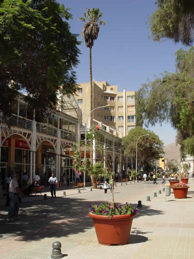
Mall Plaza Real in Copiapó, Chile. From Wikipedia.
As you’ve probably heard, after spending over 2 months in a collapsed mine, 33 miners in northern Chile are about to be lifted up to safety. The nearest town to this mine is Copiapó, so this week I thought I’d take a look at what the climate is like there.
Copiapó, in northern Chile, was founded in 1744 by the Copiapó River, which has since then dried up. The city is primarily a copper mining town (silver is also mined around there), with agriculture (grapes, olives, tomatoes, avocadoes, and citrus fruits) coming second. Because Copiapó is surrounded by the Atacama Desert, it receives very little rain. The Atacama Desert is the driest desert on Earth, even though it lies on the Pacific Coast. Primary reasons the desert is so dry include the Humbolt Current off the coast (cold waters well up off the coast, keeping the air drier) and the Andes Mountains to the west (wind comes from the west and creates a rain shadow on the leeward side of the mountains). Copiapó is home to 129,091 people.
A few more facts about Copiapó (from Wikipedia):
- Time zone: Chile Standard Time (UTC-4) or Chile Summer Time (UTC-3)
- Elevation: 1,283 feet
- Climate zone: Desert / steppe
- Average high temperature: 79 °F (26 °C)
- Average low temperature: 55 °F (13 °C)
- Average annual precipitation: 0.5 inch (12 mm)
Current weather: Copiapó is the Southern Hemisphere, so it is currently spring there with summer coming soon. High temperatures this week are expected to start in the upper 60s, getting to upper 70s by the end of the week. Lows are forecast to be in the mid-40s to lower 50s. Skies are mostly clear although there is a slight chance of a trace of rain for tonight. Fog is common at night.
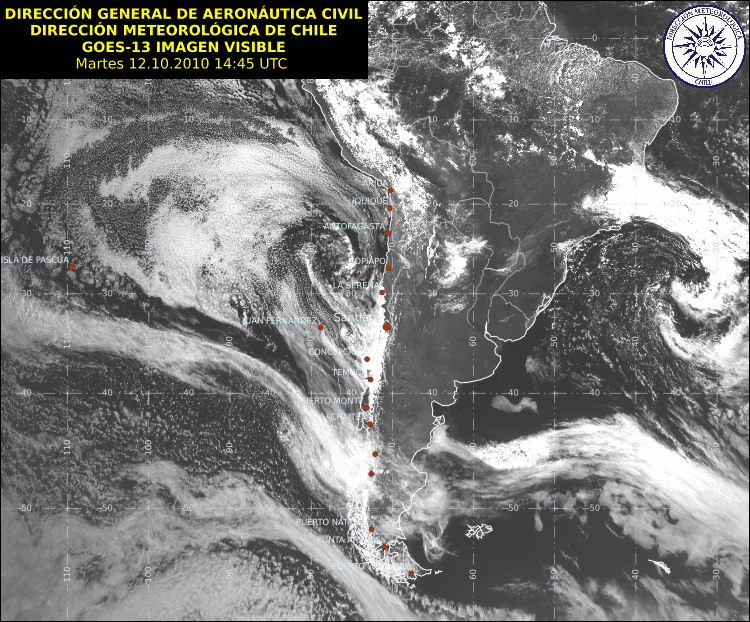
Here is a recent visible satellite image for South America, showing the location of Copiapó (from Meteo Chile, click to enlarge):

For weather maps and information on current and forecast Copiapó and Chile weather, see Meteo Chile (Chile’s meteorological agency website, in Spanish), Weather Online UK (maps, models, and forecasts for around the world), and Weather Underground.
For more information on Copiapó, here’s a link to Wikipedia, and here’s a link to Spanish Wikipedia (even more info, just in Spanish).
Next Tuesday I plan to take a look at the climate and weather in another part of the globe. As always, if you have any comments or suggestions for future cities, please leave a comment!
Permalink
Posted in General News at 11:14 am by Rebekah
I have obviously been absent from this blog for a couple of weeks, but I hope to get back to more regular posts. I apologize for keeping you waiting!
I have been plagued recently with numerous computer problems, from my primary laptop failing to my older laptop failing. My newer laptop is getting fixed up in the shop, while my older one is now back to working okay…though I don’t trust it at all. I have also had problems with Yahoo!…in case you hadn’t noticed, their servers have had some problems recently and both my webpage and this blog were not available for a little while.
I am also trying to finish my storm chasing DVD in time for the National Weather Festival at the National Weather Center here in Norman…that event is the first Saturday of November. My computer problems have prevented me from working on that for a while, but I’m back to working on it and will spend more time on the project once my college mid-term is over.
That’s what’s been keeping me the most busy…studying. I’m taking two graduate classes (Numerical Weather Prediction and Convective Clouds and Storms), and I just finished a mid-term in one of them and I will have the other mid-term a week from Thursday. Once that’s over, I can hopefully breathe a sigh of relief and move forward with some of my other projects, including the DVD. 🙂
Anyway, just thought I’d share why I have been absent lately. I’ll post the next article in the World Wide Weather series shortly.
Permalink
« Previous Page « Previous Page Next entries »


