12.31.10
Posted in Weather News, Weather Summary at 8:01 am by Rebekah
As we look to a new year tomorrow, let’s remember some of the interesting weather stories of 2010, through this summary of blog posts.
January
February
March
April
May
June
July
August
September
October
November
December
Thanks to each and every one of you for visiting my blog and website…I appreciate it!
Happy New Year 2011!!!
Permalink
12.30.10
Posted in Weather Education at 8:01 am by Rebekah
“Everybody talks about the weather but nobody does anything about it.” – Mark Twain

Depiction of cloud seeding. Courtesy of Wikipedia.
Monday’s post touched on why weather occurs and why storms are an integral part of earth’s never-ending balancing act. (See What If…We Could Prevent Storms From Occurring?)
The question remains, however, can we change the weather? Maybe we can’t or shouldn’t even try to prevent hurricanes and tornadoes from happening, but can we at least influence their strength and path?
The most common and well-known type of weather modification is cloud seeding. Cloud seeding involves spraying small particles (e.g., silver iodide) into the atmosphere, usually via airplane, in an effort to trigger cloud formation. Water vapor may then condense onto the particles, form clouds, and produce rain.
Cloud seeding has been experimented with in the U.S. (primarily in the Rockies), China, Russia, and a few other countries. Sometimes the goal is to cause rain in drought-prone areas, while at other times the goal is cause rain to fall in one area instead of another. During the Beijing Olympics of 2008, China used a form of cloud seeding to assist in preventing rain from falling (via shrinking rain drops).
While the idea of cloud seeding may seem great, there are a few problems with this method:
- it is impossible to test the effectiveness of cloud seeding (how do we know it wouldn’t have rained there anyway?)
- legal ramifications (what if you make it rain on someone else’s crop when they don’t want it to?)
- it is impossible to generate water through cloud seeding (it only works to the extent that there is already water vapor in the air)
Nevertheless, I find cloud seeding to be an intriguing, if not controversial, form of weather modification.
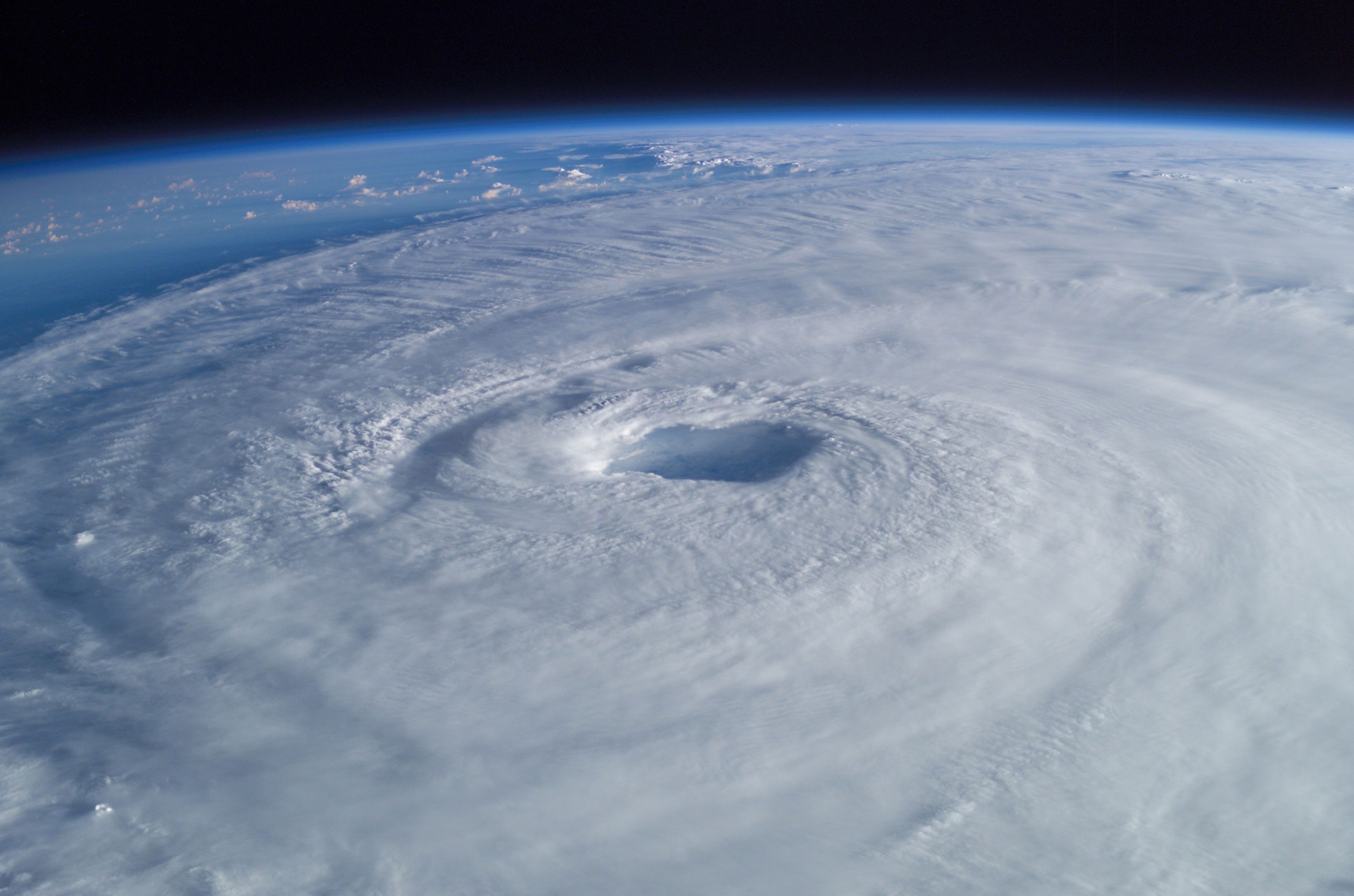
Another type of weather modification involves the weakening of tropical cyclones by seeding the eyewall with silver iodide. This method was experimented with in the 60s and 70s, with little success.

Hurricane Isabel from the ISS. Courtesy of Wikipedia.
Other proposed ways to modify hurricanes include the use of barges with upward-pointing jet engines to trigger smaller storms to disrupt the progress of a hurricane (though this was never tested, as many believed the jets would not be strong enough to make any difference) and the pouring of environmentally-friendly oils on the ocean surface to prevent evaporation and cloud formation (this, too, was later discounted as ineffective).
Some scientists believe there may be a possibility of controlling weather in the future from space. One idea is the heating of large hurricanes at certain critical points, in an effort to steer the cyclones a bit.
Finally, as with cloud seeding, weather modification in general could have the following problems:
- Effectiveness (most proposed methods have been shown to have little to no effect on the weather)
- Legal issues
- Unintended side effects (weather is chaotic and may not always respond the way you think)
- Damage to existing ecosystems (see Monday’s post…we may need storms and certain weather to maintain good living conditions for people, animals, and plants)
- Health risks
- Use as a weapon
In the meantime, the best we can probably hope for is to warn people of certain weather events ahead of time and to educate people on what they should do to protect life and property when dangerous storms do occur.
So what are your thoughts on weather modification? Should we attempt it? Why or why not?
Permalink
12.29.10
Posted in Weather News, Winter Weather at 8:01 am by Rebekah
So far for the month of December:
Seattle, Washington has had 8.59 inches of rain (3.65 inches above average).
Denver, Colorado has had NO SNOW (16.4 inches below average); in fact, no precipitation at all (0.55 inches below average).
Newark, New Jersey has had 3.87 inches of precipitation (0.78 inches above average), including 24.5 inches of snow (22 inches above average). [As an aside, check out this 40-second time lapse video from 20 hours of the blizzard in New Jersey on Sunday…it’s very impressive!]
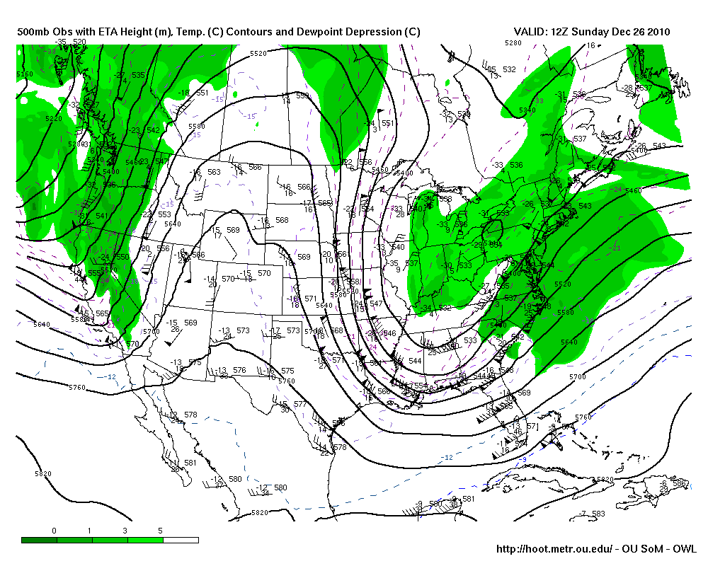
These are just a few stats at specific points, but they serve as examples of what the general weather pattern has been lately: trough in the west, ridge in the central US, and trough in the east.

Sunday (26th) morning’s 500mb map from HOOT, showing a trough in the west, a ridge over the Rockies, and a trough in the east.
This pattern is often conducive to rainy and/or snowy weather along parts of the West Coast, mild and dry weather in the Plains, and cold and snowy weather along parts of the East Coast. This pattern has some relation to La Niña, which I won’t get into in this post (see this post for how this compares to an El Niño pattern from earlier this year).
However, it looks like the atmosphere is ready for some change in the new year.
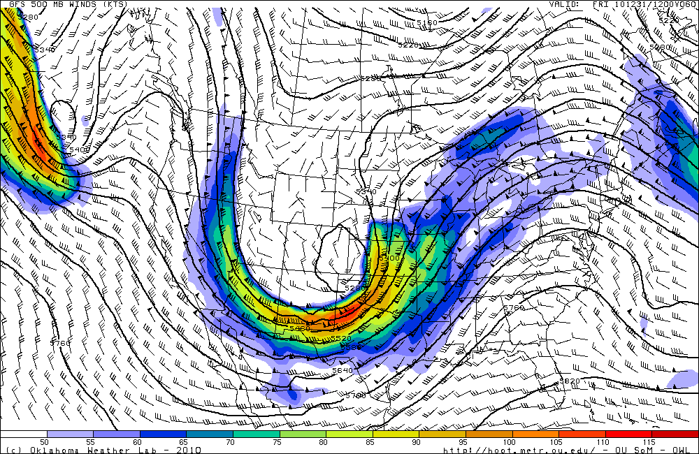
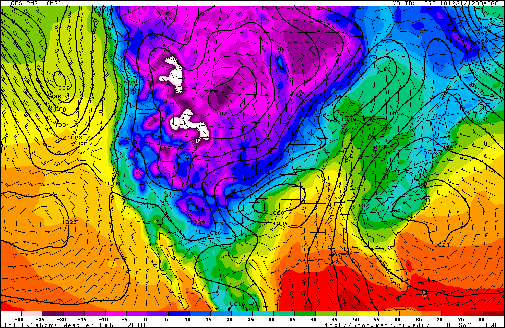
The ridge has been weakening for the last couple of days and moving eastward, which will allow a large trough to deepen and dig in over the western and central US. This will open the door for cold air to surge down into the Plains, and, with the assistance of some upslope winds, will finally allow Denver to receive several inches of snow.

GFS 500mb forecast (from HOOT) for 12Z on New Year’s Eve (i.e., morning of the 31st). Compare to the 500mb map from Sunday (above).

GFS surface analysis forecast (temperature is color-coded) for 12Z on New Year’s Eve. Note the cold air in the western US and the low pressure system over Oklahoma that will move up to Minnesota the next day.
Will we continue to see ridges over the West and troughs (and colder weather) over the central US? Will this just be the beginning of the atmosphere breaking out into a more progressive pattern?
We’ll have to wait and see!
Permalink
12.28.10
Posted in Non-US Weather, Weather News at 8:01 am by Rebekah
This week’s post in the global weather and climate series features Yogyakarta, Java, in Indonesia.

Jalan Malioboro, the most famous street in Yogyakarta for shopping and dining. Courtesy of Wikipedia.
Yogyakarta (or Jogjakarta) is a city of about 637,000 people in an area of 12.5 square miles. The city is found on the south central coast of Java, the 5th largest island in Indonesia (13th largest in the world, with a size of 51,000 square miles) and the most populated island in the world (136+ million). Situated on this volcanic island, Yogyakarta is prone to frequent earthquakes and occasional volcanic eruptions from nearby Mount Merapi.
Yogyakarta was established in 1756, under the Islamic Sultanate of Mataram. In the 1800s, the region fell into the hands of the Dutch. During the Indonesian War of Independence, from 1945, to 1949, Yogyakarta served as the capital of Indonesia.
Today, Yogyakarta is the second most important tourist destination in Indonesia (after Bali), as a result of the rich Javanese fine arts and culture found in the area, including batik dyed fabric (a manual, wax-resist dyeing technique), ballet, drama, gamelin music, poetry, silver work, and leather shadow puppet shows (wayang kulit). Yogyakarta is also home to the largest university in Indonesia, Gadjah Mada University.

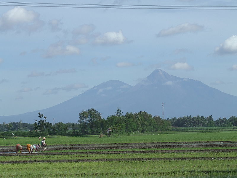
Mount Merapi (left) and Mount Merbabu, about 20 miles north of Yogyakarta. Rice farmers are in the foreground. Courtesy of Wikipedia.

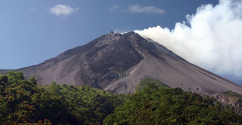
Mount Merapi, elevation 9,738 feet, is the most active volcano in Indonesia. Merapi most recently erupted in November 2010. Courtesy of Wikipedia.
A few more facts about Yogyakarta (climate data from Wikipedia):
- Time zone: Western Indonesian Time (UTC+7)
- Average elevation: 374 feet (114 meters)
- Climate zone: Tropical monsoon
- Average high temperature: 86 °F (30 °C)
- Average low temperature: 71 °F (22 °C)
- Average annual high/low temperature range: 84 to 88 °F (29 to 31 °C) / 69 to 72 °F (21 to 22 °C)
- Average annual precipitation: 86 inches (2,180 mm)
Weather: Yogyakarta is just south of the equator, at just north of 8 °S and just west of 110 °E. Because of its location, the city experiences a tropical monsoon climate. This means the temperature is warm and does not vary much throughout the year, and also means it is a rainy place but there are wet (November – April) and dry (May – October) seasons.
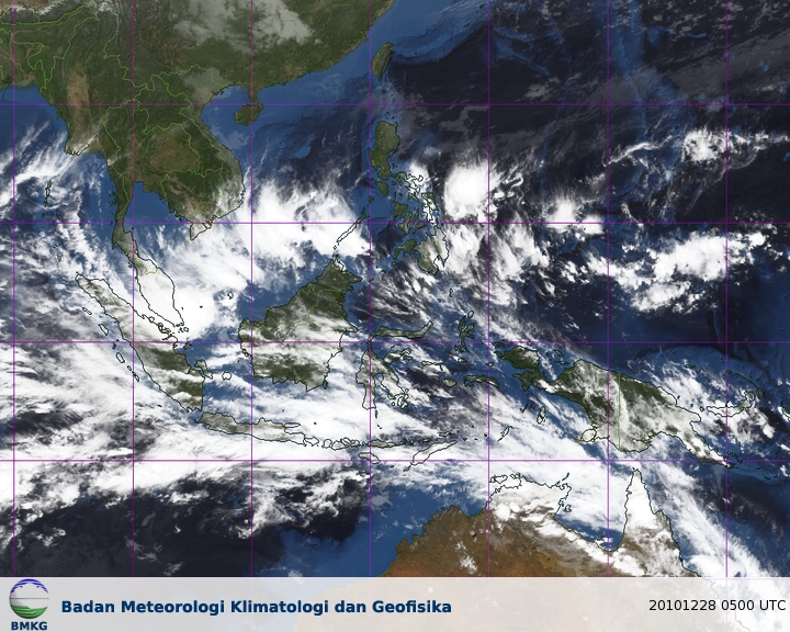
Currently, Yogyakarta is in the rainy season, with highs in the mid-80s, lows in the low 70s, and a chance of rain and thunderstorms every day. Winds are near calm.
Here’s a satellite image from the Meteorological Climatological and Geophysical Agency in Indonesia:

For weather maps and information on current and forecast Yogyakarta weather, see the Meteorological Climatological and Geophysical Agency of Indonesia, Weather Underground, and Weather Online UK.
For more information on Yogyakarta, here’s a link to Wikipedia.
Next Tuesday I plan to take a look at the climate and weather in another part of the globe. As always, if you have any comments or suggestions for future cities, please leave a comment!
Permalink
12.27.10
Posted in Weather Education, Weather Myths, What If at 10:01 am by Rebekah

Have you ever heard of weather modification?
Has anyone told you (or have you thought) that we would be doing society a favor if we could figure out how to prevent destructive storms such as hurricanes and blizzards from happening?
What do you think the earth would be like if we didn’t have these storms?
Here’s my take on this question.
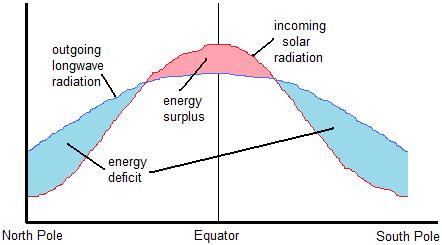
Due to the earth’s tilt, the sun heats the earth unevenly. The tropics receive more direct solar radiation than the poles.
Some of this radiation is absorbed by the earth, which subsequently emits longwave radiation back to space. The tropics, as you might guess, emit more radiation than the poles.
Now, the tropics receive more solar radiation than is emitted by the earth at the tropics…but the poles emit more radiation than they receive. This means the tropics have a net surplus of radiation and the poles have a net deficit of radiation (see figure, below).

Earth's Annual Radiation Budget
Left unchecked, this radiation imbalance would result in the tropics growing increasing hotter, and the poles growing increasing colder!
Now enter fronts, winds, high and low pressure systems, and smaller-scale thunderstorms.
Whenever something is out of balance, the earth (or atmosphere) tries to balance it out somehow. Thus, warm air must be transported towards the poles and cold air must be transported towards the tropics. An extratropical cyclone (a low-pressure system in the mid-latitudes) and its associated cold and warm fronts forms to restore equilibrium to the earth’s temperature differential.
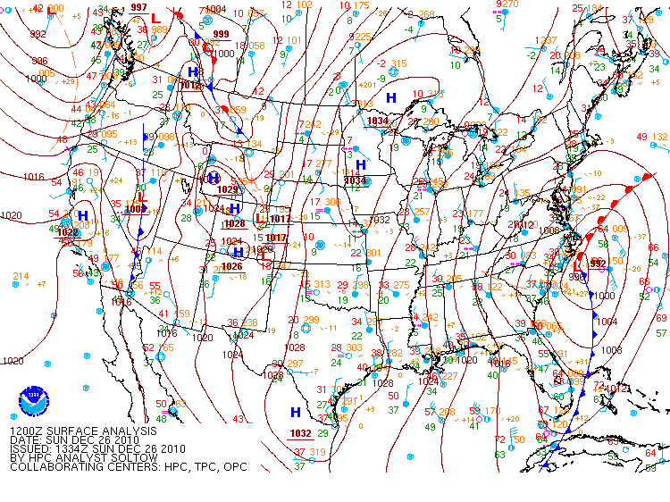
See yesterday’s surface analysis from the Hydrometeorological Prediction Center for an example of this balancing act (click to enlarge):

- Take a look at the red “L” off the coast of North Carolina. This indicates the center of the low pressure system responsible for the ongoing blizzard in the Northeast.
- Lows spin counter-clockwise in the northern hemisphere (opposite in the southern hemisphere), thus there are north and west winds that are coming around and pushing a cold front (blue line with triangles) southeastward.
- Note many temperatures (indicated by red numbers) are in the 30s behind the front.
- South-southeast winds are wrapping around the eastern side of the low, behind a warm front (red line with semi-circles) lifting northwestward.
- Note the temperatures behind the warm front are in the mid-60s.
Note also that these large extratropical cyclones usually have smaller storms that form along the fronts and/or around the low (e.g., snowstorms and/or thunderstorms). These smaller-scale storms are also attempting to balance an aspect of the environment that is out of balance. Hurricanes are another animal, but are similarly large low-pressure systems (minus the fronts) that help to balance things out.
All that to say that if we did not have weather, including occasionally severe weather, we might be in even more trouble. There is no way to stop the earth from trying to continually balance itself, but if somehow we could, the earth might soon be unlivable.
What do you think about weather modification or what the earth would be like without severe weather?
Permalink
« Previous entries Next Page » Next Page »

