01.29.11
Posted in Non-US Weather, Tropical Weather, Weather News at 8:00 am by Rebekah
Severe Tropical Cyclone Bianca, a weakening Category 3 tropical cyclone on the Australian rating system (Category 1 on the Saffir-Simpson Scale), has been taking a very strange trek along the western coast of Australia.
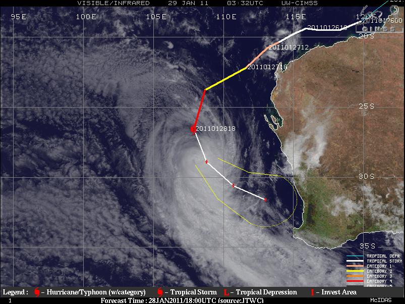
Satellite image, history, and forecast track of Bianca along Australia’s west coast. Source: CIMSS
Note how Bianca formed off the northwestern coast of Australia and proceeded to move almost parallel to the coast, all the way down to the southwestern coast, where the cyclone is expected to make landfall on Sunday.
Bianca’s maximum sustained winds are about 75 to 85 mph, but she is expected to keep weakening as she encounters cooler water temperatures and increased wind shear. The center of the cyclone is forecast to make landfall just south of Perth as a weak Aus. Cat. 1 (tropical storm on the SS-scale) or tropical low (tropical depression). Primary threats to the coast will be rough seas, heavy rainfall with possibly some localized flooding, and strong wind gusts up to about 60 mph.
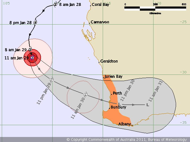
Bianca’s history and forecast track, as of Saturday morning Australian Western Standard Time, from the Australian Bureau of Meteorology
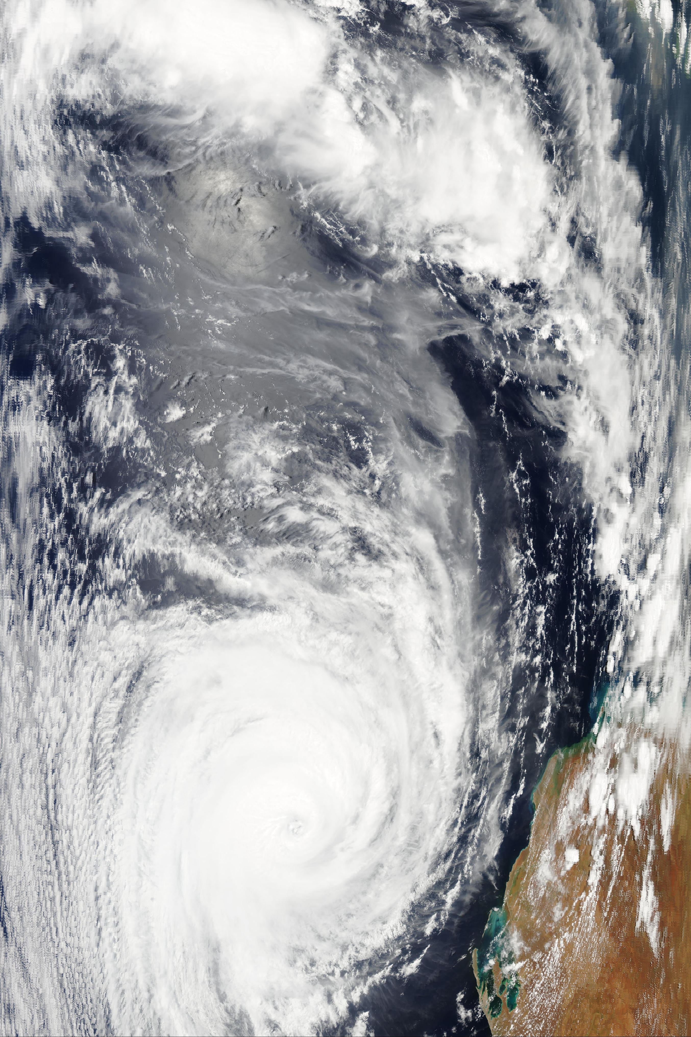
Bianca (click to enlarge), at 6:30 UTC on the 28th, via NASA’s Aqua/MODIS satellite (looks more impressive than the more recent image from early on the 29th…go to the “real-time” tab to see the latest images)
As a follow up to my post on Severe Tropical Cyclone Wilma the other day, Wilma is now only a shadow of her former self…the cyclone brushed past the northern coast of New Zealand, and now is just a low falling apart southeast of New Zealand.
For the latest on Tropical Cyclone Bianca, check out the Australian Bureau of Meteorology, Weather Underground, and CIMSS. To learn about tropical cyclone ratings in different ocean basins, check out the chart on this older blog post of mine.
Permalink
01.28.11
Posted in Winter Weather at 8:00 am by Rebekah
The Knickerbocker Storm was a blizzard that took place along the mid-Atlantic U.S. coast on January 27 – 28, 1922.
The blizzard was known for the collapse of the Knickerbocker Theatre in Washington, D.C., under the weight of heavy snow. Tragically, 98 people were killed and 133 injured when the cinema’s roof caved in.

The Knickerbocker Theater, following its collapse. Source: NOAA
Meteorological Synopsis
Nearly a week prior to the event, a sub-freezing airmass set in across the Northeast and mid-Atlantic.
A low formed off the coast of Georgia, and rapidly deepened as it began to move up the coast. A strong high pressure system in southeastern Canada prevented the low from moving northward very fast, so it took three days for it to travel up the East Coast, prolonging the event.
On the 27th, heavy snow started to fall from the Carolinas to Pennsylvania with the low off the North Carolina coast. The hardest-hit areas were from Washington, D.C. to Philadelphia. Snow fell in Washington from about noon on the 28th until the morning of the 29th. Snow totals in the city ranged from 28 to 33 inches. This went down as the biggest snowstorm in Washington since official records began in 1885.

Weather Bureau map from the morning of January 28, 1922. Source: NOAA
Impacts
Parts of the Northeast received 20 or more inches of snow, while much of the rest of the Eastern Seaboard received at least 4 inches. Some snow drifts on railroad lines between Philadelphia and Washington were as high as 16 feet.
The Knickerbocker Theatre in Washington, D.C. was just 5 years old and was the biggest cinema in town. The roof was flat, allowing the wet, heavy snow to accumulate and eventually force the roof to collapse. The balcony section came down as well, and dozens of people were buried. Hundreds of rescue workers came to help, some of them comparing the scene to one from World War I. This disaster ranks as one of the worst in Washington’s history.
Permalink
01.27.11
Posted in Non-US Weather, Tropical Weather, Weather News at 8:00 am by Rebekah
Severe Tropical Cyclone Wilma, the equivalent of a Category 3 (borderline Category 4) hurricane (as of Wednesday night) on the Saffir-Simpson scale, is about a thousand miles north of the northern island of New Zealand. As of Wednesday night, Wilma’s maximum winds were estimated at 130 mph (gusts to 160 mph). The tropical cyclone is moving west-southwest at about 13 mph, and is expected to make a gradual turn on Friday and may brush the northern coast of the northern island of New Zealand as a tropical storm on Saturday (if she holds together that long).
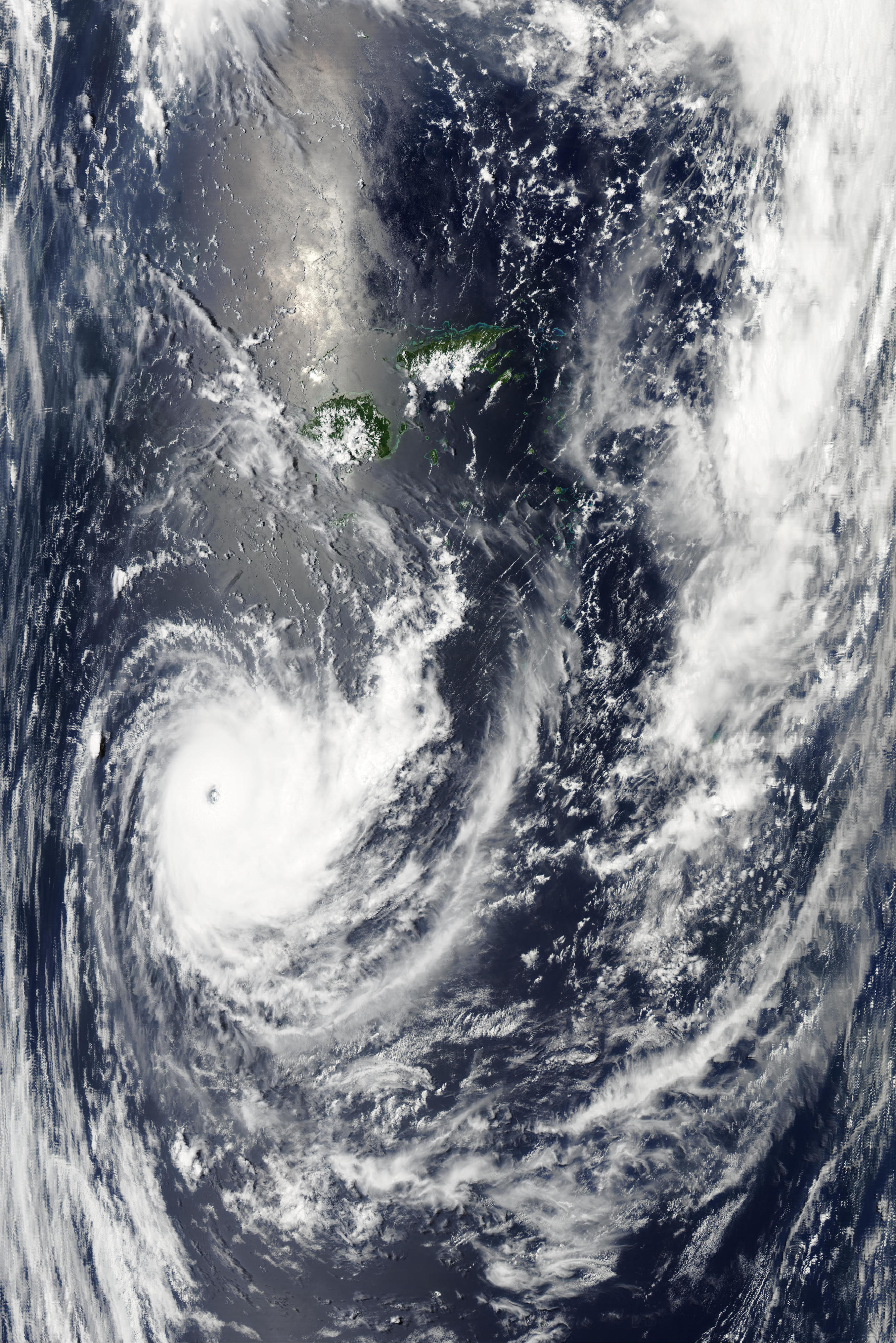
Aqua/MODIS image of Tropical Cyclone Wilma at 01:45 UTC…to zoom in to as much as 250 m resolution, see the NASA MODIS website, scroll down to the Aqua images from the 26th, and look towards the bottom right for 01:45 UTC.
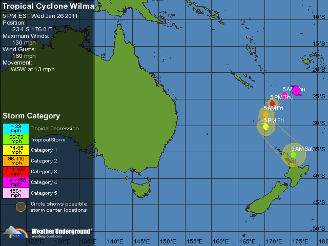
Wilma’s forecast track via Weather Underground
Permalink
01.26.11
Posted in Non-US Weather, Weather News at 8:00 am by Rebekah
There are a lot of places around the world that have been flooding lately; here’s a list of some of them, based on a photo gallery from The Guardian:
- Eastern Australia – the floodwaters are not just affecting Queensland but Victoria now as well
- Southern Philippines (Davao del Sur province, on the southern island of Mindanao) – flooding following weeks of heavy rain
- Southern Thailand – another case of heavy rain causing flooding
- Sri Lanka – more rain fell in some areas from early December to mid-January than typically falls in a year
- South Africa – rivers have risen to great heights and flooded a number of areas
- Poland – flooding from snow melt
- Southern Sweden – recent heavy snow melt
- Belgium – flooding from rain and snow melt
- Netherlands – more rain and melting snow
- Central Germany – massive flooding caused by melting snow; barge supplies going to Frankfurt airport via the Rhine River have been stopped, causing more problems
- Northern France – rain and melting snow again
- East Central Scotland – heavy rain and melting snow causing some major flooding
- Southeastern Brazil – severe flooding caused mudslides that killed hundreds of people
- Northern Colombia – unusually heavy rains have caused river levels to rise
- Western Washington – heavy rains in the Pacific Northwest have caused some flooding off and on this winter
In addition to The Guardian‘s photo gallery, I found a photo gallery on the New York Post website.
Permalink
01.25.11
Posted in Non-US Weather, Weather News at 8:00 am by Rebekah
This week’s post in the global weather and climate series features Istanbul, Turkey.

Montage of Istanbul, Turkey. Source: Wikipedia
Istanbul, formerly known as Byzantium and Constantinople, is situated on the Bosphorus Strait that runs from the Sea of Marmara to the Black Sea. The Bosphorus divides the city into a European and an Asian side, making Istanbul the only bi-continental city in the world. Istanbul also sits near the North Anatolian Fault, the boundary between the African and Eurasian plates. This fault has been responsible for several major earthquakes, including one in 1999 that killed over 17,000 people in and around Istanbul.
Istanbul’s rich history can be traced back to at least the 7th century BC. Istanbul, like Rome, has been called “The City of Seven Hills”, as the oldest part of the city is built on seven hills, each of which bears a historic, imperial mosque.
Istanbul and the surrounding area produce cotton, fruit, olive oil, silk, and tobacco. The city is the economic center of Turkey and an important city in the global economy. According to Forbes magazine, as of March 2008, Istanbul had 35 billionaires, ranking 4th in the world. With a population of about 12.8 million, Istanbul is the largest city in Turkey and the 5th largest city proper in the world.
A few more facts about Istanbul:
- Time zone: Eastern European Time (UTC+2) or Eastern European Summer Time (UTC+3)
- Average elevation: 121 feet (37 meters)
- Climate zone: Mediterranean
- Average high temperature: 66 °F (19 °C)
- Average low temperature: 51 °F (11 °C)
- Average annual high/low temperature range: 48 to 83 °F (9 to 29 °C) / 37 to 66 °F (3 to 19 °C)
- Average annual precipitation: 33 inches (844 mm)
Weather: It’s currently rainy and cool in Istanbul, with highs in the 40s and lows in the 30s. There is a trough over eastern Europe right now, with a surface low just southwest of Istanbul. This low will move up over Turkey, bringing a continued chance for rain.
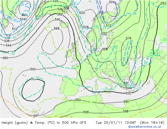
500mb height and temperature forecast (initialized at 18Z on Monday) for Europe at 12Z, from Weather Online UK
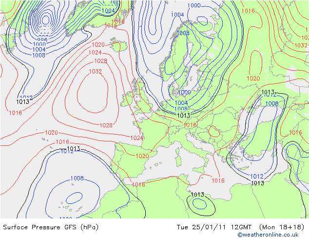
Surface pressure forecast (initialized at 18Z on Monday) for Europe at 12Z, from Weather Online UK
For weather maps and information on current and forecast Istanbul weather, see the Turkish State Meteorological Service (there is an English version; see the top right of the page), Weather Underground, and Weather Online UK.
For more information on Istanbul, here’s a link to Wikipedia.
Next Tuesday we will take a look at the climate and weather in another part of the globe. As always, if you have any suggestions for future cities, please leave a comment!
Permalink
« Previous Page — « Previous entries « Previous Page · Next Page » Next entries » — Next Page »


