01.10.11
Posted in Weather Education at 8:00 am by Rebekah
Last Monday we took a look at some basic definitions in meteorology, including meteorology, the atmosphere, weather (as well as why we have weather), and climate.
Today we’re going to start reviewing the elements of weather, starting with temperature.
————————————————–
Elements of Weather
Temperature
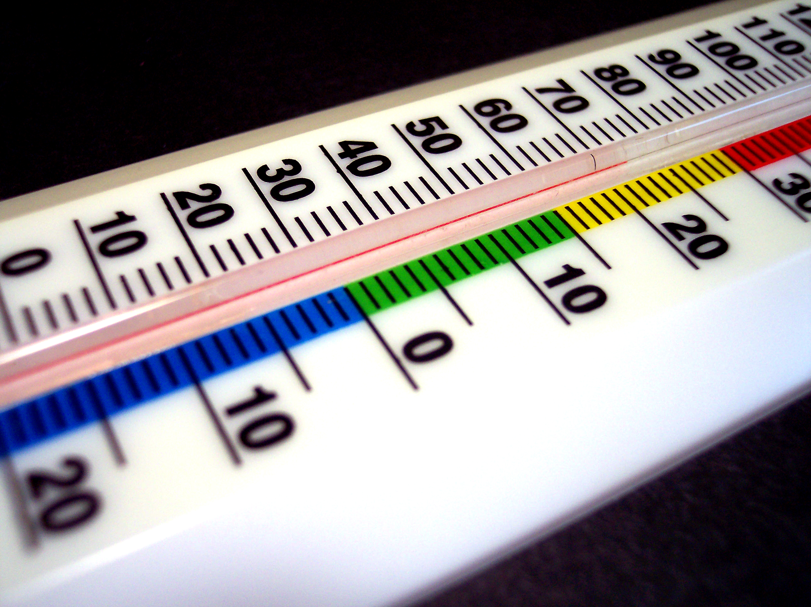
Temperature is a measure of the kinetic energy of all the molecules in a substance. The faster the molecules are moving, the higher the temperature. Alternatively, you can think of it the other way around; for example, the warmer a pot of water, the more the water molecules are moving (i.e., the water may eventually evaporate)…or, the colder a pot of water, the less the molecules are moving (i.e., the water may eventually freeze).
Temperature Scales
There are 3 primary temperature scales: Fahrenheit, Celsius, and Kelvin. Click here to see more on these temperature scales, including how to convert between the three.
Temperature Structure of the Atmosphere

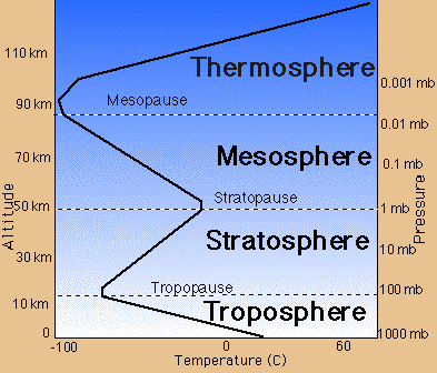
Source: NASA
Categorized by air temperature, there are four layers of the atmosphere:
- Troposphere – the lowest layer of the atmosphere…air temperature generally decreases with height, as the earth is better than air at absorbing incoming solar radiation (thus it is kept warmer)
- Stratosphere – above the troposphere (the boundary is known as the tropopause)…air temperature generally increases with height, as a layer of ozone efficiently absorbs solar radiation
- Mesosphere – above the stratosphere (the boundary is known as the stratopause)…air temperature generally decreases with height, for the same reason as the troposphere
- Thermosphere – above the mesosphere (the boundary is called the mesopause)…air temperature generally increases with height, as there is such a lack of air molecules (the few molecules that are there do not have to “share” as much solar radiation with other molecules, thus they become more energetic)
————————————————–
Come back next Monday to learn about pressure, another element of weather.
Permalink
01.09.11
Posted in Weather Education at 8:01 am by Rebekah
Have you ever stopped to think what meteorologists and climatologists mean by the words “average” and “normal“?

When your local TV weathercaster tells you that today’s temperature is 10 degrees below normal, do you just assume that average/normal means the average quantity (e.g., temperature) for that time period (e.g., January 9th) over all years in recorded history?
If so, you might be surprised to find that average/normal typically means something else in meteorology and climatology.
The climate of any given place changes over time; the earth as a whole naturally goes through cold, warm, wet, and dry cycles (this is true regardless of man’s impact on the atmosphere). This being the case, taking the average temperature, for example, of New York from the 1800s to 2010 may not give a very good picture of the typical temperature you might expect to find in New York.
In meteorology and climatology, we take the average value of a quantity over a 30-year period ending with the end of the last decade, and call that value the average, or the normal.
This means that from 2001 through 2010, the average annual rainfall for Seattle is defined as the annual rainfall averaged from 1971 through 2000.
Now that we’ve moved on to a new decade, we’ll be moving on to a new set of averages: those from 1981 through 2010.
Will this affect how we define our “normal” weather? Yes. In many cases there will not be much of a difference, but take temperature, for example. The 1970s were cooler than the 2000s, thus the new average temperatures for many places will be warmer.
Permalink
01.08.11
Posted in General News at 5:06 pm by Rebekah
I’ve posted chase logs and photos on the website for June 14 (north Texas shelf clouds), June 15 (east Texas Panhandle thunderstorm), June 23 (north central Oklahoma / south central Kansas thunderstorms), June 24 (southeast Colorado thunderstorm), June 25 (southwest Minnesota supercell and squall line), and June 26 (east South Dakota supercell and squall line). Check it out! I’ll be posting more of these soon.
Permalink
Posted in Weather Forecast, Weather News, Winter Weather at 8:00 am by Rebekah
Weather Discussion

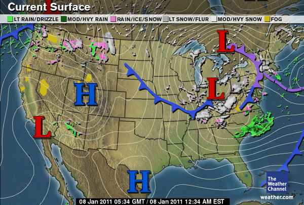
National: The primary features on satellite and upper-air maps are the large low-pressure system over the Northeast and the split-flow over the West, including a shortwave trough over the Northwest, a ridge over the northern Rockies, and a shortwave trough over the Southwest.
Rain and snow is ongoing in the Cascades and northern Rockies, a large surface high is located over the Great Basin, and the mature cyclone over the Northeast is bringing snow to New England and the Ohio River Valley. An arctic front extending across the central part of the country is bringing cold temperatures to the Plains as well as a chance for freezing rain and snow.
Southern Plains: The shortwave trough over the Southwest will dip down into Texas on Sunday, increasing lift and the chances for rain and snow in the wake of the cold front. Ground temperatures will probably be too warm for much snow accumulation; the greatest chance for snow would be in eastern Oklahoma, where temperatures are expected to be colder.
The type of precipitation is rather tricky to forecast for Oklahoma…forecast soundings for central Oklahoma Sunday evening show a saturated profile just at or below freezing. This means snow could fall, but if the temperature winds up just a little warmer than forecast, we could get just rain or even freezing rain. On the other hand, it looks a bit more certain that a snow/sleet event is building for the Arklatex region on Sunday and sleet/freezing rain for the Southeast on Monday and Tuesday.
On Monday, a trough will deepen over the Rockies and the exit region of a jet streak will be over Oklahoma. This will enhance lift and there will be another chance for some wintry precipitation. Forecast soundings for central Oklahoma again show saturated profiles just below freezing. Northern Oklahoma may get a bit more snow on this day.
The cooler weather will continue throughout the week…high temperatures in Oklahoma will primarily be in the 30s, with lows in the 20s. The latter half of the week should remain dry but breezy.
Permalink
01.07.11
Posted in Winter Weather at 8:00 am by Rebekah
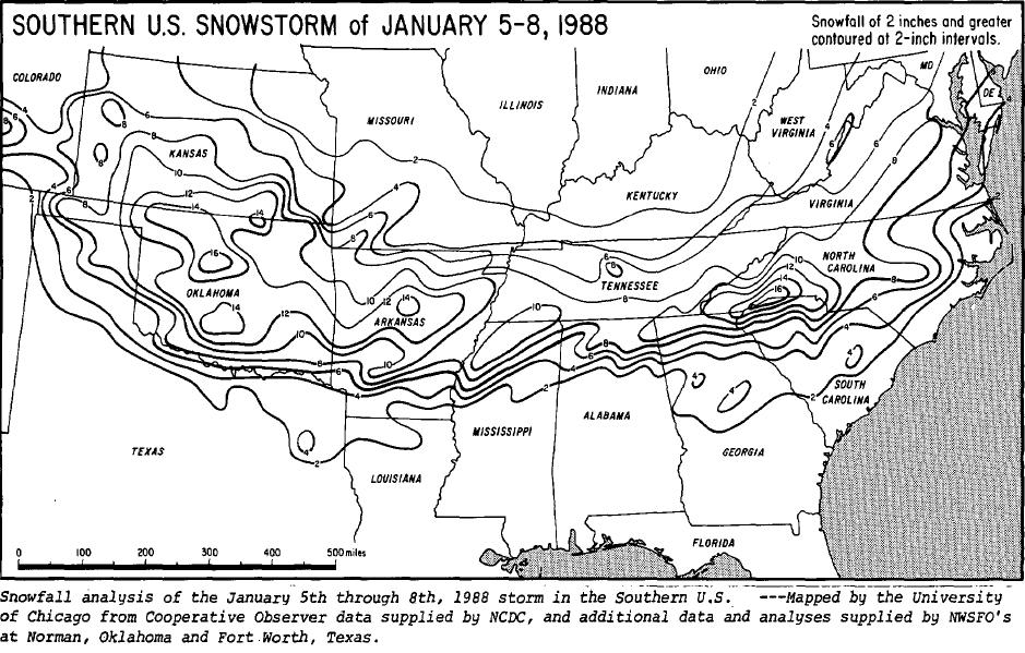
From January 5 – 8, 1988, a winter storm dumped over a foot of snow and sleet across the southern United States. Over 3 million chickens were killed in Alabama, Georgia, and Texas, following the collapse of dozens of poultry houses due to the weight of snow and ice.

Snowfall totals from the Rockies to the mid-Atlantic coast. Most states affected received at least 8 inches of snow. Far northwestern South Carolina reported an unofficial snowfall total of 27 inches. Courtesy of NCDC/Storm Data. Click to enlarge.
Timeline
- Monday, January 4th: A cold front associated with a deep trough over the central and eastern U.S. brought well-below-average, sub-freezing temperatures deep into the Southeast
- Wednesday, January 6th: A new shortwave trough developed and tracked over the Southern Plains, inducing the formation of a weak surface low just off the Texas Coast…snow was already falling in Oklahoma, and began to fall in far northern Mississippi and Alabama and southern Tennessee
- Thursday, January 7th: The surface low set up near Mobile, Alabama, allowing slightly warmer air to advance northward…this resulted in precipitation changing to sleet and freezing rain…later in the evening, much of the precipitation turned back to snow
- Friday, January 8th: Snow tapered off in the Southeast, although strong winds continued to cause significant snow drifts…meanwhile, the surface low strengthened along the East Coast and brought snow to the mid-Atlantic states and New England
Aftermath
Sub-freezing temperatures continued even after the storm had passed, allowing snow and ice to remain on the ground for several days.
Many schools were closed for the week and roads were closed for days throughout much of the Tennessee River Valley. Many flights in the areas affected were delayed or canceled during the storm. Some power outages lasted for several days in the southern states more affected by the ice.
About 60 people died as a result of the snow and cold this week.
Governor Guy Hunt declared a state of emergency for northern Alabama, after about 2 million chickens were killed due to the collapse of their shelters, resulting in over $15 million of damage. Over half a million chickens also perished in eastern Texas, and another half a million died in northern Georgia.
Sources: NWS Huntsville January 1988 Winter Storm; Winter storm across the nation (Ocala Star-Banner); Dead chickens called public health threat (The Tuscaloosa News); Storm may boost poultry prices (The Dallas Morning News).
Permalink
« Previous Page — « Previous entries « Previous Page · Next Page » Next entries » — Next Page »
