03.11.11
Posted in Weather News at 8:00 am by Rebekah

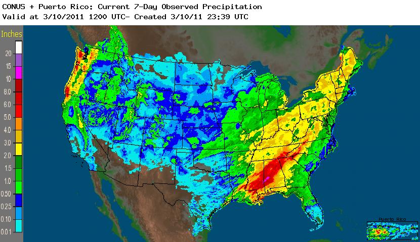
7-day total precipitation across the U.S., from the National Weather Service (click to enlarge)
Probably the biggest weather story in the U.S. right now is the flood event in the Northeast. Between melting snow and copious rainfall, many rivers are at or near flood stage.
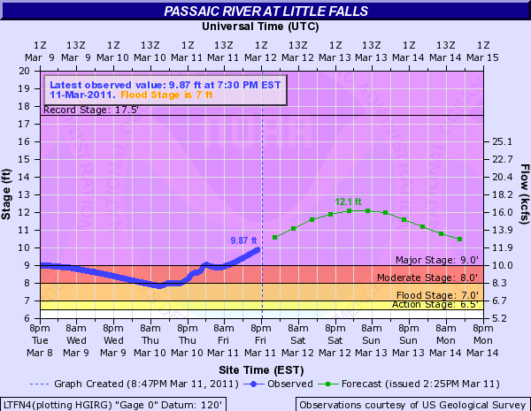
For example, the Passaic River at Little Falls, in northern New Jersey, is expected to peak at 12 feet tomorrow night. Flood stage is 7 feet and major flood stage is 9 feet.

Hydrograph from the National Weather Service
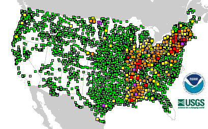
The Passaic River is not the only river to watch, though; the following National Weather Service map shows the number of river gauge stations that are at or near flood stage. Yellow is near flood stage, orange is minor flooding, red is moderate flooding, and pink is major flooding (green is no flooding).

Welcome to spring!
Permalink
03.10.11
Posted in General News at 8:00 am by Rebekah
Yesterday I went to a very interesting seminar on the extreme weather events lately in Australia, and how they may be tied to La Niña, natural climate variability, and climate change. I took some notes from the talk and plan on writing up a summary of the seminar for the blog next week.
Today I just want to give you a taste of one of the many projects I’m working on in the lightning research group at OU.
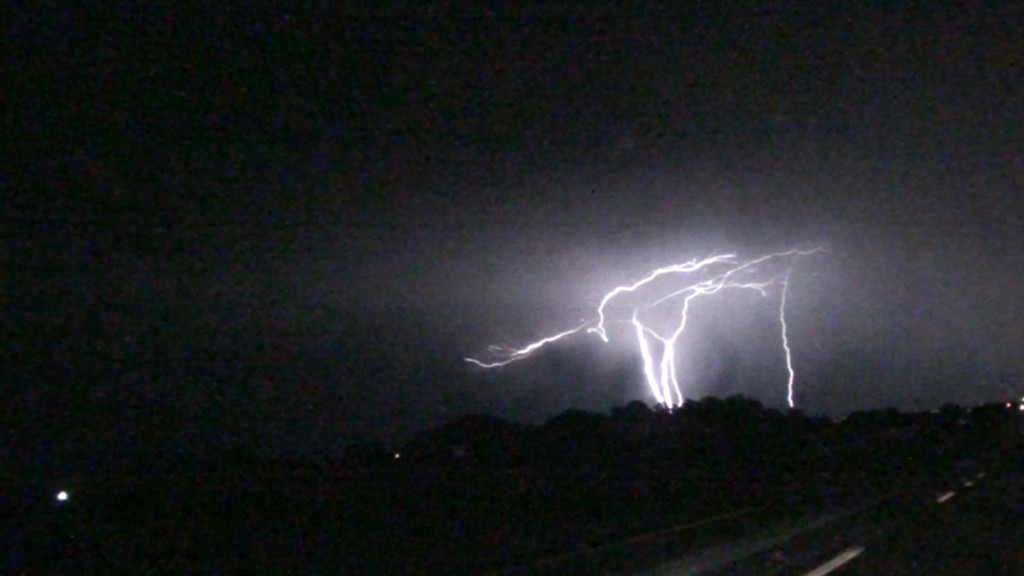
Lately I’ve been analyzing a lightning flash that got my attention last July. While coming back from a chase in northern Oklahoma on July 11th, I saw a lightning stroke that went from the ground to the cloud. I know this type of lightning occurs in areas with tall towers, but I had never seen this with my own eyes before. Now I’m looking at lightning data for the storm and also looking into studying upward-going lightning in other storms, as well as studying up on the literature on the subject as I don’t know much about it.

Captured with my HD camcorder.
Permalink
03.09.11
Posted in Weather News at 8:00 am by Rebekah
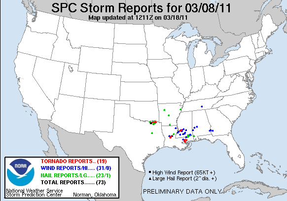
Despite yesterday’s moderate risk and tornado watch for Louisiana, there wasn’t a lot of activity in this area.

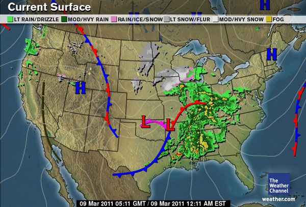
Another side to this storm system is the snow in the Upper Midwest and all the rain around the Southeast and Mississippi River Valley.

Image from The Weather Channel, at about midnight Eastern Time.
There is a slight risk for severe weather along the northern Gulf Coast today, and then after that it looks like our next chance for severe weather might be early next week or even later.
Permalink
03.08.11
Posted in Weather News at 8:00 am by Rebekah
This week’s post in the global weather and climate series features McGrath, Alaska.

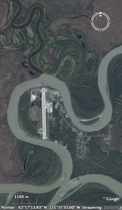
Satellite view of McGrath, on the Kuskokwim River. From the Alaska Lake Ice and Snow Observatory Network
McGrath is a town of 401 people (2000 census) on the Kuskokwim River in southwest / south central Alaska. While the village is in a valley at only 331 feet elevation, McGrath is situated on the western edge of the Alaska Range and not far from Mount McKinley.
Established as a trading post in 1904, McGrath grew with the discovery of nearby gold and the need for a supply post in interior Alaska. Today, McGrath is an important transportation hub and receives visitors every year as a result of its location along the Iditarod Trail. Mushers participating in the Iditarod race will soon be coming in to McGrath.
See the Iditarod web site for info on the current standings/locations of the teams, and see the Weather Underground Iditarod page for weather info along the trail.
A few more facts about McGrath (weather data from the Western Regional Climate Center):
- Time zone: Alaska Standard Time (UTC-9) or Alaska Daylight Time (UTC-8)
- Average elevation: 331 ft (101 m)
- Climate zone: Boreal forest / taiga (long, cold winters and short, cool summers)
- Average high temperature: 36 °F (2 °C)
- Average low temperature: 16 °F (-9 °C)
- Average annual high/low temperature range: 1 to 69 °F (-17 to 20 °C) / -17 to 50 °F (-27 to 10 °C)
- Average annual precipitation: 17 inches (434 mm)
- Average annual snowfall: 91 inches (230 cm)
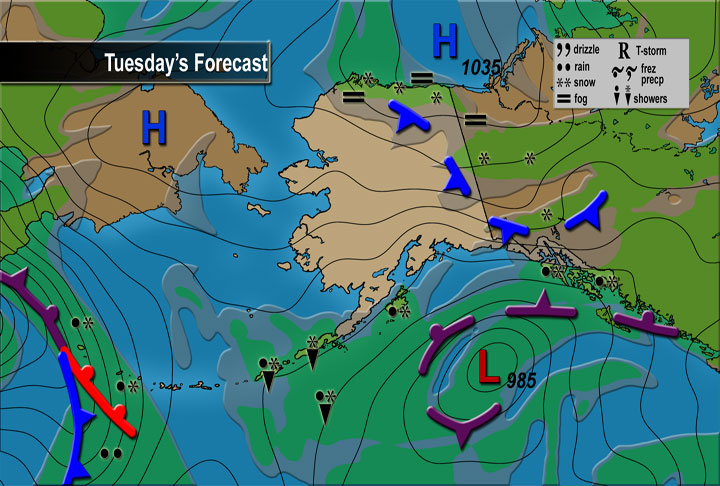
Weather: McGrath experiences pretty cold winters with a fair amount of snowfall each year, though summers can be pleasant and drier. The high today is forecast at around 15 °F, with a low tonight of 10 to 15 below. Skies will remain clear and winds will be light. This weather is expected to continue through much of the week (might get a little colder towards the end of the week).

Bigger picture of what’s going on in Alaska, from the National Weather Service
For weather maps and information on current and forecast McGrath weather, see the National Weather Service and Weather Underground.
For a bit more information on McGrath, here’s a link to Wikipedia.
Next Tuesday I plan to take a look at the climate and weather in another part of the globe. As always, if you have any suggestions for future cities, please leave a comment!
Permalink
03.07.11
Posted in Weather Education at 8:00 am by Rebekah
While last week we looked at how surface observations are made, this week we’ll look at how upper-air observations are made, focusing on weather balloons (some measurements may be taken by aircraft, as well).
Radiosondes

(Radiosonde photo from Wikipedia)
The primary instrument for measuring upper-air weather data is a radiosonde. A radiosonde is a small box that measures temperature, relative humidity, pressure, wind speed and direction, altitude, and GPS location. (Technically, a radiosonde doesn’t measure wind…instruments that do are called rawinsondes, but colloquially we still like to call them radiosondes.)
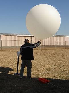
The radiosonde is attached to a large, hydrogen-filled balloon, which can ascend to over 100,000 feet in altitude, at which point the balloon could have expanded to the size of a two-story building! Data is transmitted to the surface throughout the balloon’s flight.

(Photo courtesy of the National Weather Service)
As the balloon expands as it rises (due to lower pressure higher in the atmosphere), it will eventually pop and come back down (sometimes prematurely). The ascension can last for two hours, at which time the instrument may have reached over 100,000 feet in altitude and may have drifted well over 100 miles away from the point of release.
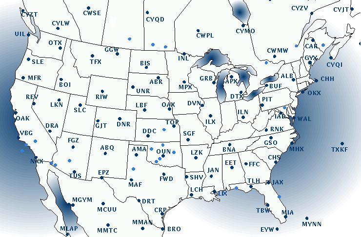
Weather balloons are launched twice a day at over 400 locations around the world, around 12Z and 00Z (remember the universal time zone we talked about recently?). The following figure from the College of DuPage shows where radiosondes are launched in the U.S. (as well as southern Canada and northern Mexico). The light blue spots are supplemental sites where balloons are launched only on special occasion (in case of severe weather, snowstorm, etc.).

We’ll discuss how this upper-air data is plotted a little later in the series.
————————————————–
Next Monday we will take a look at remote sensing observations, including radar and satellite.
Permalink
« Previous Page — « Previous entries « Previous Page · Next Page » Next entries » — Next Page »
