01.03.10
Arctic Cold
Under the grip of an unusually cold airmass for this time of year, much of the eastern US is experiencing temperatures remain well below average.
The National Weather Service recorded a temperature of -38 °F at Grand Forks, North Dakota early Saturday morning; factoring in winds of 8 mph when the air temperature was -36 °F (winds were calm when the temperature was at its coldest) yields a wind chill of -58 °F (-50 °C)!!
International Falls, Minnesota set a record temperature of -37 °F early Saturday, only to tie it early this morning! The NWS is currently predicting a low of -33 °F in International Falls tonight, so there is a chance they will tie that new record again, if not break it.
Lake-effect snow continues across the Great Lakes, and heavy snow continues throughout the New England area as the 978 mb low-pressure system off the Northeast Coast refuses to show signs of going anywhere fast.
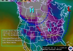
An even colder arctic airmass will quickly surge southward along the Rockies into the Plains Tuesday night through Wednesday. I fly back to Oklahoma on Tuesday and it looks like I will get there just in time to experience perhaps some light snow along the cold front Wednesday night and the coldest temperatures of the season so far Thursday night/Friday morning (8 °F with wind chills as low as -10 °F). Brr! I can’t say I’m a fan of the cold weather; Oklahoma weather is just about right for me, as the area gets just enough cold weather and wintry precipitation to keep me happy, but not so much that I get tired of it (a little more snow from time to time would be nice, though–but I missed the big Christmas Eve Blizzard!).

NWS graphic forecast of arctic blast on Wednesday.