02.12.10
O Canada…
The winter Olympics began today in Vancouver and Whistler. The breath-taking shots of Canada and the Vancouver area that have been shown during the opening ceremonies tonight are beyond description. I miss the beauty of the Pacific Northwest so much; all the more so when I see such stunning images.
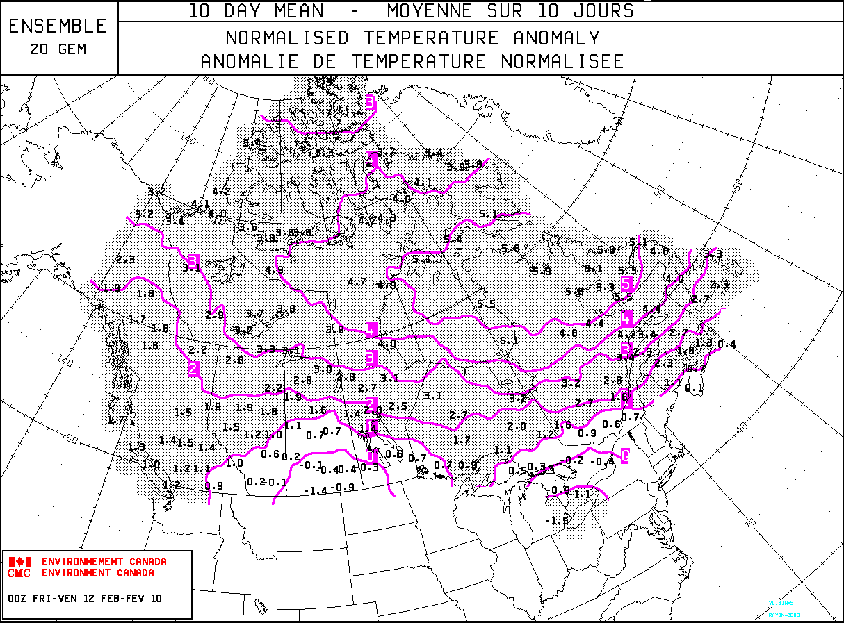
You may have heard that Vancouver is experiencing a warm and dry winter. However, on the up side, Whistler (where many of the outdoor events will take place) has already received record snowfall this year. What’s in store for the next two weeks of the Olympics? The following image shows a model forecast of Canada’s temperature anomaly (departure from normal, in degrees Celsius) over the next 10 days. As you can see, most of the country is experiencing and expecting above-normal temperatures!
So why has it been warm and dry in the North, but cold in the South and East? To continue from yesterday’s post, some of this has to do with El Niño. However, there are many other climate anomalies that affect temperature and precipitation patterns. One such anomaly is the North Atlantic Oscillation (NAO).
There is a semi-permanent low-pressure center near Iceland, called the Icelandic Low. There is also a semi-permanent high-pressure center near the Azores, called the Azores or Bermuda High. A positive NAO means both the high and the low are stronger, thus there is a stronger pressure gradient from high to low pressure. Storms tend to take a northwest track that bring warmer and wetter winters to northern Europe while eastern US winters tend to be mild.
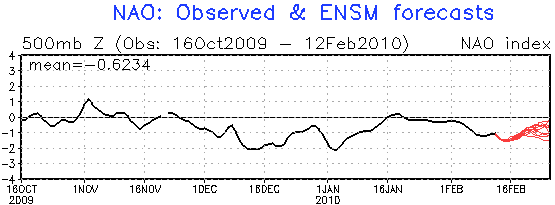
A negative NAO means both the high and low are weaker (and sometimes shift their positions). Typical climate patterns include cold and dry winters in northern Europe and cold winters in the south central and eastern US. The following image is a graph of positive and negative NAOs.
Note that during the cold stretch of weather in mid-December in the eastern two-thirds of the country, there was a moderately negative NAO. Also note that there was a moderately negative NAO during the cold period in early January. The red lines at the end of the graph show several models’ forecasts for the NAO phase–according to this, it looks like the cold weather may not yet be over, which agrees with model temperature forecasts for the next week and a half!
So cold plus moisture (remember El Niño) equals snow…which is what we’ve obviously been getting a lot of lately in the South and the East. In the meantime, the Northwest remains dry and mild. There is another climate anomaly that affect temperature and moisture in the Northwest, and it is called the Pacific Decadal Oscillation (PDO). Not much is known yet about the PDO, but we do notice that a negative PDO tends to bring colder temperatures and a positive PDO tends to bring warmer temperatures. We started the winter in a negative PDO, which was probably responsible in some part for the cold, snowy weather in the Northwest early in the winter. However, unfortunately for Vancouver, the PDO has gone back towards the neutral phase, thus the warming effects of El Niño are able to take over a little more.
There are some pretty amazing visual effects going on in the opening ceremony of the Olympics right now. The use of projectors to make the stadium look like ice or water or whales or whatever is pretty cool. Go US (and then Canada!)! 🙂

