03.12.11
Pacific Tsunami, Northeast Flooding, and Oklahoma Fires
Yesterday was a pretty wild day, from the Japanese earthquake and the Pacific tsunami to wildfires in Oklahoma and Texas and flooding in the Northeast.
Here are some U.S. tsunami amplitudes I found via the National Weather Service (note the amplitude is the height above normal sea level):
LOCATION – TIME – AMPLITUDE
———————————————–
PORT ORFORD OR – 1724UTC – 6.1FT/1.85M
ADAK AK – 1755UTC – 3.6FT/1.09M
KODIAK AK – 2211UTC – 0.9FT/0.28M
LOS ANGELES CA – 2115UTC – 1.7FT/0.51M
SAN DIEGO CA – 2131UTC – 1.7FT/0.51M
LA JOLLA CA – 2007UTC – 1.4FT/0.43M
WESTPORT WA – 1920UTC – 2.0FT/0.62M
ST PAUL IS. AK – 1228UTC – 2.1FT/0.65M
OLD HARBOR AK – 2154UTC – 1.1FT/0.33M
DUTCH HARBOR AK – 1204UTC – 1.3FT/0.41M
SHEMYA AK – 1136UTC – 5.2FT/1.58M
ARENA COVE CA – 1834UTC – 8.7FT/2.65M
CRESCENT CITY CA – 1656UTC – 8.2FT/2.49M
SAN FRANCISCO CA – 1749UTC – 2.1FT/0.64M
MONTEREY HARBOR CA – 2013UTC – 2.4FT/0.72M
NORTH SPIT CA – 1639UTC – 3.3FT/1.01M
PORT SAN LUIS CA – 1745UTC – 8.6FT/2.64M
SANTA BARBARA CA – 2229UTC – 3.2FT/0.97M
SANTA MONICA CA – 2223UTC – 2.8FT/0.84M
————————-
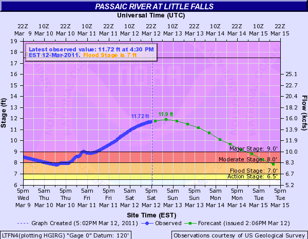
In other news, the Passaic River is still nearing its crest, now expect to peak around 12 feet tonight.
Also, Oklahoma yesterday was going up in flames (as well as parts of Texas and Colorado); the governor declared a state of emergency for the entire state, as we had at least three dozen or so wildfires burning as a result of strong winds (gusting to 47 mph), temperatures near 80, and very dry conditions. Several grass fires wound up burning a few homes, as firefighters were having a very difficult time trying to get these fires under control.
