03.11.10
Rex Block
Severe weather is still occurring in Florida this afternoon, where at least one more tornado has already been spotted. Severe storms and steady rain are expected to continue for the next few days along the East Coast. What’s going on?
On Sunday, a shortwave trough entered California from the Pacific. By the time the surface low pressure system associated with the trough moved into southern Colorado Monday morning, the low had started to occlude. A surface low, a.k.a. extratropical or mid-latitude cyclone, generally starts to weaken when its cold front catches up to its warm front. Cold air is more dense than warm air, so it moves faster and eventually catches up to the warm front; this process is called occlusion. The tornadoes in Oklahoma on Monday occurred near the point of occlusion.
The last couple of days there has been some severe weather in the warm sector of the slow-moving cyclone; this is the relatively warm area between the cold front and warm front, south of the occluded front. Unfortunately the cyclone isn’t going anywhere fast, as eventually it will become completely occluded and just sit and spin away from the fronts.
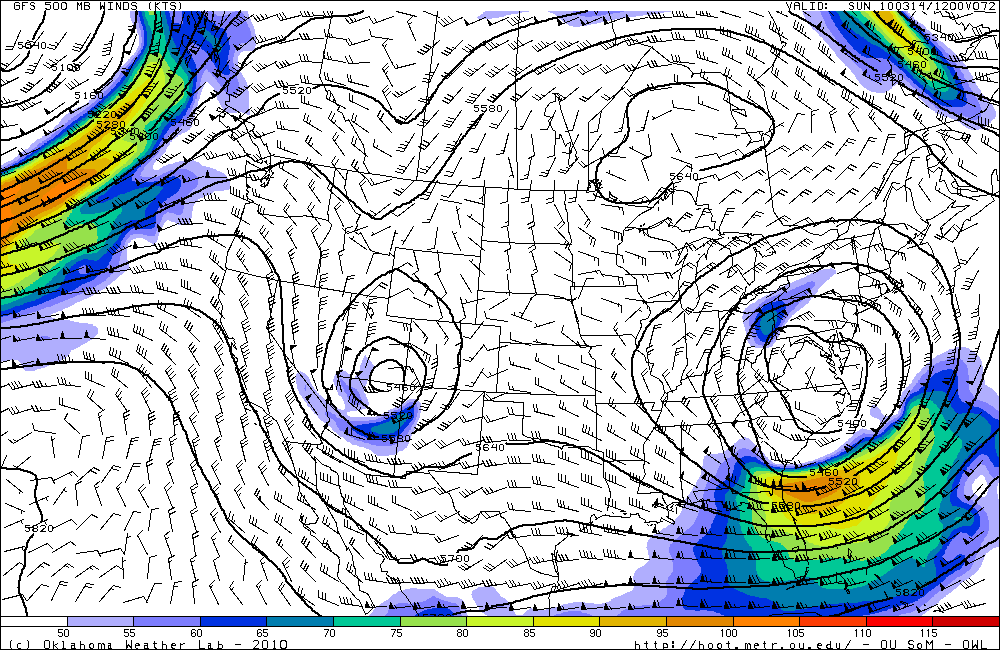
I took a look at the GFS and NAM models today and noticed the ridge in the west and the ridge in the east are building and expected to merge above the upper-level low. This results in a large ridge of high pressure situated above a closed low. The GFS model further shows that a closed high may develop within the ridge, directly above the low. This is called a high over low block, or a “rex” block. There are several blocking patterns that frequently occur, all of which prevent pressure systems from quickly moving across an area. This particular type of block means that air will flow in an S-shape, clockwise around the high and then back counter-clockwise around the low. In other words, the low is in no hurry to go anywhere, and will only bring more rain to the East Coast (especially the Northeast). It looks like the rex block will be strongest over the weekend, before breaking up and allowing the low to progress out into the Atlantic.
GFS model forecast for Sunday at 12Z, at 500 mb, showing the ridge/high above the low in the mid-levels of the atmosphere:
The GFS model also is starting to show a potentially decent severe storm setup over southern Kansas and Oklahoma next Friday…that’s still over a week away, so it will likely change by quite a bit. It may be an interesting setup to watch, though…

Green Sky Chaser » Blocking and Flooding said,
March 14, 2010 at 3:19 pm
[…] my post on Thursday, regarding rex blocks? The extratropical cyclone that brought tornadoes to the central US several […]
Green Sky Chaser » Severe Thunderstorms in Arkansas said,
March 27, 2010 at 1:52 pm
[…] is currently an occluded low-pressure system centered over north central Oklahoma/south central Kansas. This low-pressure […]