04.01.10
Return of the Moisture
Here we go!
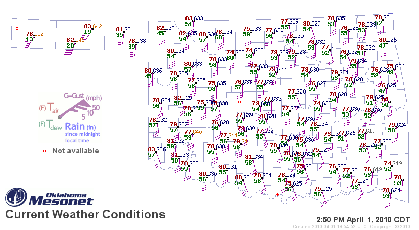
Oklahoma dewpoints are finally in the mid-50s; some dewpoints in western Oklahoma are already up to 60 today, ahead of a dryline. Note the surface map below (click to enlarge), as of 2:50pm, from the Oklahoma Mesonet.
As the legend shows, dewpoint is the number in green. The higher the dewpoint, the more moisture there is in the air. For thunderstorms, especially severe thunderstorms, chasers often look at 60 °F as the magic number.
Note that in the panhandle, dewpoints are in the teens — this is because there is a dryline in the panhandle, or a line where dewpoints are low on one side (with winds usually from the west) and high on the other side (with winds usually from the south or southeast). Temperature is given in the red numbers, while the staffs/barbs at each station indicate wind direction (mostly from the south in this case) and speed (based on number of barbs on the staff).
There is a slight risk of severe thunderstorms today in western Oklahoma, but the cap (temperature inversion that acts as a “lid” to rising air) is so strong it is unlikely that much of anything will break through it.
Tomorrow there is also a risk of severe weather, but primarily east of here. The next time I go chasing may be early next week, as it looks like we will not only have a decent trough, but also finally have the moisture and instability we’ve so desperately needed. The actual day and location is still rather up in the air, but as the models start to resolve the details of the setup, I will begin to have a better idea.
Stay tuned…
