01.23.10
Severe Weather Outlook Today
Here’s my outlook for the chances of severe weather this evening:
There’s a large trough over the western U.S. today, with a surface low in Nebraska. An occluded front stretches south from the low, through western Missouri and western Arkansas. A cold front extends into eastern Texas while a warm front extends through southern Arkansas into Mississippi.
Southeasterly surface winds are bringing moisture from the Gulf of Mexico into the warm sector in Louisiana and southern Arkansas. Temperatures in the warm sector are in the upper 60s and lower 70s with dewpoints in the upper 50s to mid-60s. Instability isn’t the greatest (CAPE of only about 1000 J/kg in the Arklatex region), and soundings this morning showed a cap over much of the region, but upper-level forcing should be great enough to break the cap. A 250mb jet exists over much of Texas, while a 850mb jet of 50 knots is over the Louisiana/Mississippi border into southeast Arkansas. Positive vorticity advection is occurring around northeast Texas into the Arklatex region. There is also a lot of Q-vector convergence in Louisiana, as well as isentropic lift in Louisiana, Arkansas, and Mississippi.
There is already a line of mostly stratiform precipitation along the occluded and cold fronts, with a few convective cells beginning to grow along and ahead of the cold front. Clouds in the area will limit surface heating, which could be a concern for increasing instability; however, a dry slot is entering the Arklatex region, which could be helpful for cooling the air aloft and increasing lapse rates.
Directional and speed shear is sufficient for rotation, and 0 to 1 km and 0 to 3 km SRH values are over 400 m^2/s^2 (local maxima in southeast Arkansas of 550).
I would expect convection to increase in coverage along the line over the next few hours, with perhaps some strong bow echoes or even a few supercells embedded within the line. I would venture that the greatest threat is hail and high winds, although I would not rule out the possibility of a few isolated tornadoes in southeast Arkansas and northern Louisiana into western Mississippi, especially later tonight provided the low-level jet strengthens even further.
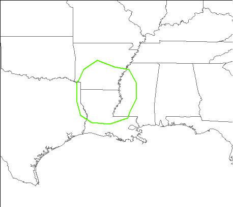
The following map shows where I forecast the greatest severe threat to be this evening/tonight.
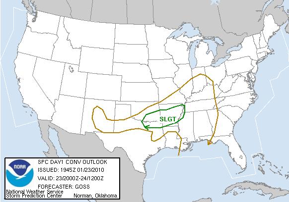
As opposed to the latest SPC outlook:

