09.14.10
World Wide Weather #17: Naples (Napoli), Italy
This week’s post in the global weather and climate series features Naples, Italy.

The Bay of Naples, from the Sant’Elmo Castle. Mount Vesuvius is on the left. Courtesy of Wikipedia. Click to enlarge.
Naples (Napoli in Italian) is one of the oldest cities in the world, founded sometime in the 9th century BC. It is needless to say that Naples has a long, rich European history, as the city has seen several civilizations come and go. Naples is situated on the Bay of Naples, on the southwest Italian coast. The city lies in the shadow of Mount Vesuvius, which famously blew up in 79 AD, burying the city of Pompeii for nearly 1600 years.
A few more facts about Naples (from Wikipedia):
- Time zone: Central European Time (UTC+1) or Central European Summer Time (UTC+2)
- Elevation: 0 to 56 feet
- Climate zone: Mediterranean (mild, wet winters, warm/hot, dry summers)
- Average high temperature: 69 °F (20 °C)
- Average low temperature: 51 °F (10 °C)
- Average annual precipitation: 39.6 inches (1,007 mm)
Naples’ average monthly low and high temperatures range from 39 °F to 85 °F.
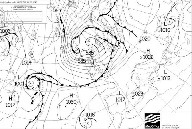
Current weather: Southern Italy is currently under weak low pressure, with no big disturbances nearby (see below, from the UK Met Office). The weather is pretty mild, with highs in the upper 70s this week and lows in the lower 60s. Skies are clear, but there is a slight chance for rain tonight. Low pressure systems are staying primarily in northern Europe, with high pressure systems south of Italy, so the weather is expected to remain pleasant.
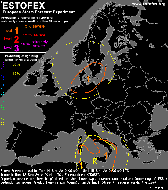
Italy occasionally gets severe thunderstorms, especially in the fall. ESTOFEX, the European Storm Forecast Experiment (forecasts for severe weather in Europe), has actually predicted a slight risk of severe storms over southern Italy for today and tonight (see below). This severe weather risk is at 5% for severe weather within 40 km (25 miles) of a point. Severe weather is defined as a tornado, hail of up to 2 cm (0.79 in) in diameter, wind speeds of at least 25 m/s (56 mph), or excessive rainfall of 60 mm (2.4 in) in 3 hours or 90 mm (3.5 in) in 6 hours.
The discussion for southern Italy read (emphasis added):
“Areas from Thyrrenian sea southwards into the southern Mediterranean will be affected by the slowly moving upper low. Moderate instability seems to become available, which should support deep convection. Despite the rather limited shear in place, as the mid-level jet slowly weakens, numerous organized storms will form. Multicells and a couple of rotating storms can be possible. Given their rather slow moving nature, they should bring threat for intense rainfalls as well as some marginal hail in the beginning before they cluster. Train-effect of the storms should locally enhance flash floods. Warm SSTs and steep LL lapse rates could also result in a couple of waterspouts.”
The ESTOFEX website can be found here.
For weather maps and information on current and forecast Neapolitan (yes, that’s of Naples) and Italian weather, see Meteo Italia (Italy’s weather service), Weather Online UK (maps, models, and forecast for around the world), and Weather Underground.
For more information on Naples, here’s a link to Wikipedia.
Next Tuesday I plan to take a look at the climate and weather in another part of the globe. As always, if you have any comments or suggestions for future cities, please leave a comment on this post!

