06.08.10
Posted in Non-US Weather, Weather News at 3:48 pm by Rebekah
This week’s post in the global weather and climate series features Cairo, Egypt.
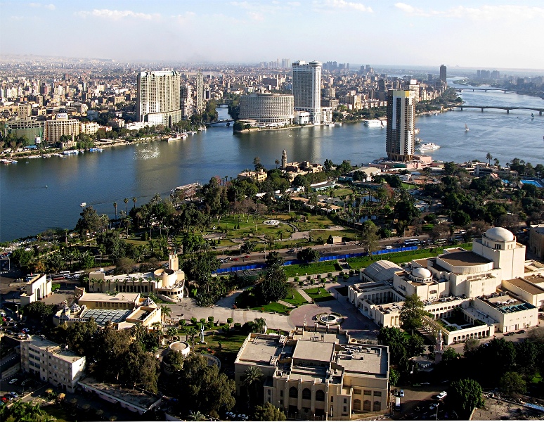
View of Cairo, Egypt from Cairo Tower. Courtesy of Wikipedia. Click to enlarge.
Centered along the banks of the Nile River, Cairo is located in northeast Egypt, about 100 miles south of the Mediterranean Sea and about 75 miles west of the Suez Canal. Cairo has a long and rich history, probably most often associated with the Great Sphinx and the Pyramids of Giza, located near the suburbs of Cairo. The capital of Egypt and the largest city in Africa, Cairo is home to 6.8 million people (about 18 million in the metro).
A few more facts about Cairo (from Wikipedia):
- Time zone: Eastern European Time (UTC+2) or Eastern European Summer Time (UTC+3)
- Elevation: about 75 to 250 ft above mean sea level
- Climate zone: Desert
- Average high temperature: 81 °F (27 °C)
- Average low temperature: 59 °F (15 °C)
- Record high temperature: 117 °F (47 °C)
- Record low temperature: 34 °F (1 °C)
- Average annual precipitation: 1 inch (29 mm)
Current weather: I could not dig up much information on recent or current Egyptian weather, partly because the website for Egypt’s national meteorological agency, the Egyptian Meteorological Authority, is down right now (see link, below).
However, Weather Underground is forecasting clear skies this week with high temperatures in the low to mid-90s and lows in the upper 60s to lower 70s, as is typical this time of year.
Here is an infrared satellite image, showing the clear skies over Egypt as of 18Z (9pm Cairo time, 2pm New York time). Note there are clouds over Libya (west of Egypt), as well as clouds over the tropics.
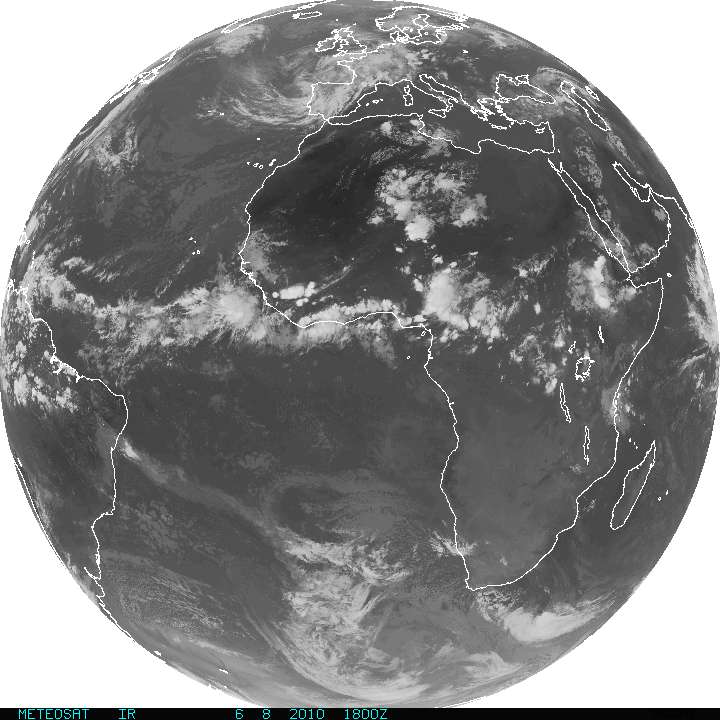
METEOSAT infrared satellite image (from http://www.goes.noaa.gov). Click to enlarge.
For more information on Cairo, here’s a link to Wikipedia.
For weather maps and information on current and forecast Cairo weather, see the Egyptian Meteorological Authority (I have yet to look at this site as it is currently down) or Weather Online UK (great collection of weather maps and models for all over the world).
Next Tuesday I plan to take a look at the climate and weather in another part of the globe. As always, if you have any comments or suggestions for future cities, please leave a comment on this post!
Permalink
05.25.10
Posted in Non-US Weather, Weather News at 4:47 pm by Rebekah
After taking a 6-week break in my global weather and climate series, in order to focus on work and posts on storm chasing, I’m finally coming back to the series.
Here’s what continents I’ve done so far (my goal was to pick a different continent each week, cycling through all seven for as long as there is interest in the series).
#1 – Australia (Perth, Australia)
#2 – Europe (Edinburgh, Scotland)
#3 – South America (Rio de Janeiro, Brazil)
This week, for the fourth post in the series, I will take a look at Kochi (formerly known as Cochin), India.
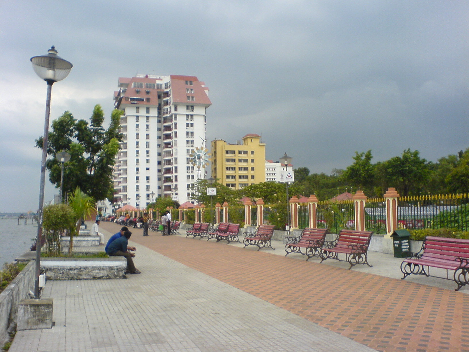
Kochi, India (image courtesy of Wikipedia).
Located in southwest India, on the coast of the Arabian Sea, Kochi is home to about 600,000 people (approximately 1.5 million in the metro). Kochi, sometimes known as the “Queen of the Arabian Sea”, has long been one of the most important spice trading centers on the Arabian Sea. As the first European colonial settlement in India, Kochi was the capital of Portuguese India for nearly 30 years in the early 16th century. Growth in shipping industries, tourism, and information technology have continued to boost Kochi’s economic growth.
A few more facts about Kochi (from Wikipedia; some weather data from Weatherbase):
- Time zone: India Standard Time (UTC+5:30)
- Elevation: 0 ft above mean sea level
- Climate zone: Tropical monsoon (hot/wet summers, warm/moist winters)
- Average high temperature: 86 °F (30 °C)
- Average low temperature: 77 °F (25 °C)
- Record high temperature: 100 °F (38 °C)
- Record low temperature: 63 °F (17 °C)
- Average annual precipitation: 108 inches (2,740 mm)
The forecast for Kochi this week is thunderstorms every day with highs in the low to mid-80s and lows in the mid- to upper 70s. Why is it so stormy? Note also that Kochi receives over 100 inches of rain per year, and most of that rain comes during the summer months (June to September).
A seasonal shift in winds, resulting in a seasonal shift in precipitation, is called a monsoon.
Put most simply, water has a higher heat capacity than land, so in the summertime, the Indian peninsula heats up more than the surrounding water. This warmer region of air starts to rise (often aided by the Himalayas), creating a low pressure system. The low pressure, in turn, draws the moist air from the sea in towards the land, thus allowing many thunderstorms to form and much rain to fall (see figure below).
In the wintertime, the land cools down faster than the water. A surface high pressure system forms over the land, and blows air out to sea, keeping India drier than it would be otherwise (see figure below).
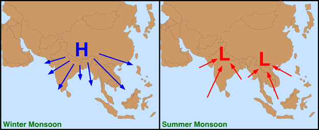
Winter and summer monsoon patterns for southeast Asia (courtesy of physicalgeography.net).
The following figure illustrates the approximate dates for the southwest summer monsoon to arrive at different regions of India.
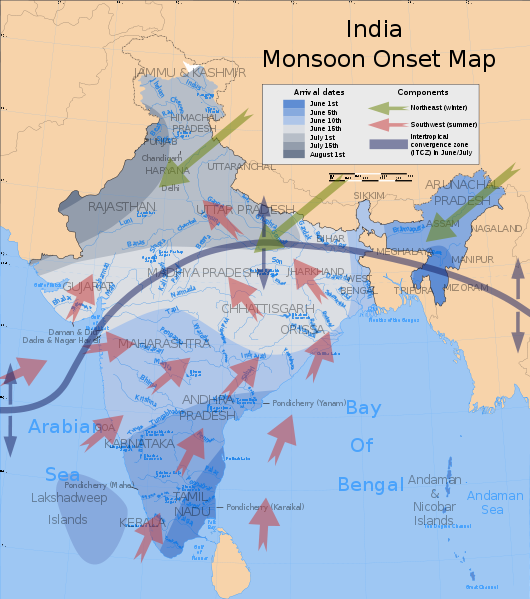
Southwest summer monsoon onset map (courtesy of Wikipedia).
As you can see, the monsoon should soon be arriving at Kochi (Kochi is in the state of Kerala). The India Meteorological Department (IMD) posted the following Monsoon Watch last night:
“The Northern limit of Monsoon (NLM) continues to pass through Lat.5.0°N/ Long.70.0°E, Lat.5.0°N/ Long.75.0°E, Lat. 8.0°N/Long. 80.0°E, Lat. 12.0° N/ Long. 84.0°E, Lat. 15.0° N/ Long. 87.0°E, Lat. 18.0° N/ Long.90.0°E and Lat. 21.0° N/ Long. 93.0° E.”
Note that Kochi is located at about 10°N and 76°E, meaning the northern edge of the monsoon is just a few degrees south and east of Kochi at this time.
I have heard some predictions that the monsoon should be getting off to a good, rainy start this year (more so than last year, anyway), especially as there is currently a heat wave going across northern, western, and central India with temperatures peaking at about 50°C (122°F).
Weather Trends International has some information on the monsoon outlook, as well as some maps showing forecast precipitation totals by month.
For more information on Kochi, here’s a link to Wikipedia.
For weather maps and information on current and forecast Kochi weather, see the India Meteorological Department (don’t worry, it’s in English!) or Weather Online UK (great collection of weather maps and models for all over the world).
Next Tuesday I plan to take a look at the climate and weather in another part of the globe. We still have North America, Africa, and Antarctica before starting over again. As always, if you have any comments or suggestions for future cities, please leave a comment on this post!
Permalink
04.13.10
Posted in Non-US Weather, Weather News at 5:19 pm by Rebekah
This week’s featured city, in my series on global weather and climate, is Rio de Janeiro, Brazil.

Rio de Janeiro, Brazil. Courtesy of Wikipedia. Click to enlarge.
Located in southeast Brazil, on the Atlantic Coast, Rio is home to about 6.2 million people (approximately 14.5 million in the metro). Rio de Janeiro, Portuguese for “River of January”, was the capital city of Brazil until 1960, when Brasília became the capital. Near the Tropic of Capricorn, Rio is the main tourist destination in the Southern Hemisphere and will host the final match of the 2014 FIFA World Cup and the 2016 Summer Olympics (the first city to host the Olympics in South America).
A few more facts about Rio de Janeiro (from Wikipedia):
- Time zone: Brasília Standard Time (UTC-3) or Brasília Daylight Time (UTC-2)
- Elevation: 0 to 3,350 ft above mean sea level
- Climate zone: Tropical savanna (hot/wet summers, mild/dry winters)
- Average high temperature: 86 °F (30 °C)
- Average low temperature: 68 °F (20 °C)
- Record high temperature: 109 °F (43 °C)
- Record low temperature: 45 °F (7 °C)
- Average annual precipitation: 43 inches (1,090 mm)
Recent/current weather: Last week Rio de Janeiro and surrounding areas were hit hard by heavy rains; reportedly the heaviest rain in nearly 50 years. Rio de Janeiro received about 11 inches of rain within 24 hours on Tuesday/Wednesday. Massive flooding and landslides have sadly resulted in the deaths of over 200 people, and have left thousands without homes.
What caused the rain? One big reason has to do with the low-pressure system sitting off the southern Brazilian coast last week (see figure, below). In the Northern Hemisphere, low pressure turns counter-clockwise and high pressure turns clockwise; however, in the Southern Hemisphere, low pressure turns clockwise and high pressure turns counter-clockwise. Thus the strong low-pressure system produced southerly and southeasterly winds in the Rio area, bringing a lot of tropical, moist air from the south Atlantic onshore. Steep terrain around Rio de Janeiro also contributed to the rainfall, as warm, moist air can produce clouds and rain as it rises up a hill or mountain.
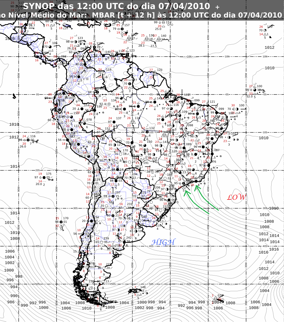
Surface analysis of South America on 7 April 2010, at 12Z (9am Rio de Janeiro time). Map courtesy of INMET. Note the 1004 mb closed low off the coast of Brazil, and the 1028 mb closed high off the coast of Argentina. Green arrows denote approximate wind direction. Click to enlarge.
As the low left the area, it was replaced by a high, which is bringing more easterly winds to Rio (this is the typical wind direction in the tropics). As Rio de Janeiro’s coast primarily runs east/west, these easterly winds are assisting in producing some rain, but not nearly as heavy of rain as was associated with the low. In addition, highs are associated with sinking air, so naturally there should not be as much rain.
For more information on Rio de Janeiro, here’s a link to Wikipedia.
For weather maps and information on current and forecast Rio de Janeiro weather, see the Instituto Nacional de Meteorologia (INMET, i.e., Brazil’s National Institute of Meteorology — warning, it’s in Portuguese!) or Weather Online UK (great collection of weather maps and models for all over the world).
Next Tuesday I’ll take a look at the climate and weather in another part of the globe. As always, if you have any comments or suggestions for future cities, please leave a comment on this post!
Permalink
03.30.10
Posted in Non-US Weather, Weather News at 9:48 am by Rebekah
Last Tuesday I started a series of posts on global weather, focusing on current weather and climate of places around the world. The inaugural post took a look at Perth, Australia.
This week’s featured city is Edinburgh, Scotland, in the United Kingdom.
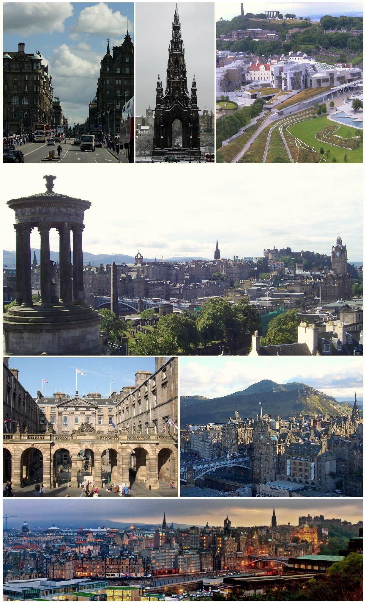
Edinburgh, Scotland. Courtesy of Wikipedia.
Situated in southeast Scotland, near the North Sea, Edinburgh is home to nearly 500,000 people (about 1.2 million in the metro). Edinburgh is the capital of Scotland and the second most popular tourist destination in the UK, behind London. A few facts about Edinburgh (climate data from Weatherbase):
- Time zone: Greenwich Mean Time (UTC+0) or British Summer Time (UTC+1)
- Elevation: ~135 ft above mean sea level
- Climate zone: Maritime (warm/moist summers, cool/wet winters)
- Average high temperature: 53 °F (11 °C)
- Average low temperature: 41 °F (5 °C)
- Record high temperature: 88 °F (31 °C)
- Record low temperature: 1 °F (-17 °C)
- Average annual precipitation: 26 inches (663 mm)
Current weather: This afternoon it is raining in Edinburgh, with a temperature of 38 °F (3.2 °C) as of 3pm local time. The pressure is 987 mb and falling. Not far north of the city it is snowing, and as cold air surges southward, the snow is expected to be heavy over parts of Scotland and Ireland.
The following shows a radar image (from the UK Met Office) at 3pm local time:
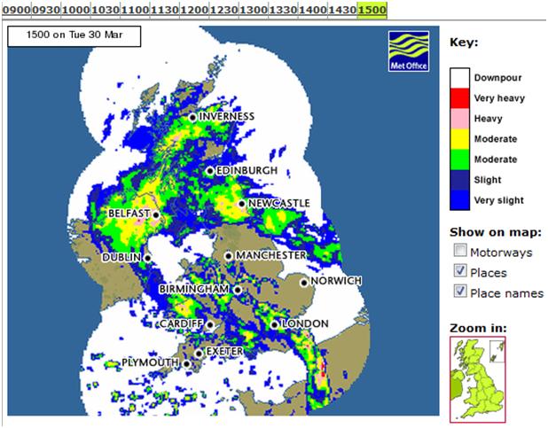
This rain and snow is associated with an extratropical cyclone that is making landfall on the Irish and British coasts. I can’t find any very good current surface maps of the UK, but here’s a 9-hr model run (initialized at 06Z and valid at 15Z, or 3pm local time), showing surface pressure contours (from Weather Online UK).
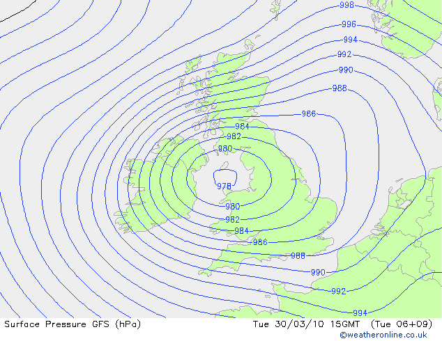
There is a pretty tight pressure gradient with this storm system, so not only will it bring sub-freezing temperatures to Scotland, but it will bring strong winds (roughly 35 mph in Scotland, 40 to 50 mph in western Scotland and northern Ireland, with gusts to 82 mph) that will blow the snow around and cause blizzard conditions in much of the country.
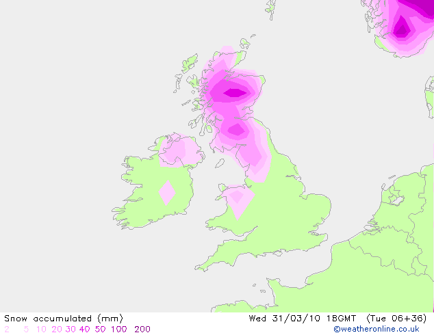
The UK Met Office (equivalent of the NWS in the US) is forecasting for 40 cm (about 16 inches) of snow or more in the Highlands of Scotland through Wednesday. The prediction of snow and gale-force winds prompted the UK Met Office to issue an early weather warning on Sunday, for heavy snow and blizzards over much of Scotland (and northern Ireland). That warning was updated today to an emergency weather warning for severe blizzards, severe drifting snow, and very heavy snowfall. Obviously, Edinburgh, sitting on the coast, won’t receive as much snow, but the city may still get a few inches that will get blown around in the winds.
Here’s the GFS model (from Weather Online UK) of 6-hr snow accumulation, ending after the heaviest snow through 18Z (7pm local time) on Wednesday. This map shows a max of 40 – 50 mm of snow over the Highlands from 12Z to 18Z Wednesday.
For more information on Edinburgh, here’s a link to Wikipedia.
For more information on the ongoing blizzard, here’s the BBC weather news page.
For weather maps and information on Edinburgh weather, including the latest weather warnings, see the UK Met Office or Weather Online UK (great collection of weather maps and models for all over the world).
Next Tuesday I’ll take a look at the climate and weather in another part of the globe. As always, if you have any comments or suggestions for future cities, please leave a comment!
Permalink
03.23.10
Posted in Non-US Weather, Weather News at 3:20 pm by Rebekah
Today marks the start of a series of posts on global weather. Most of us, understandably, are most concerned with the climate and weather in our particular neck of the woods; however, I think it can be both fun and educational to take a look at weather in other parts of the globe.
This week’s featured city is Perth, Australia.
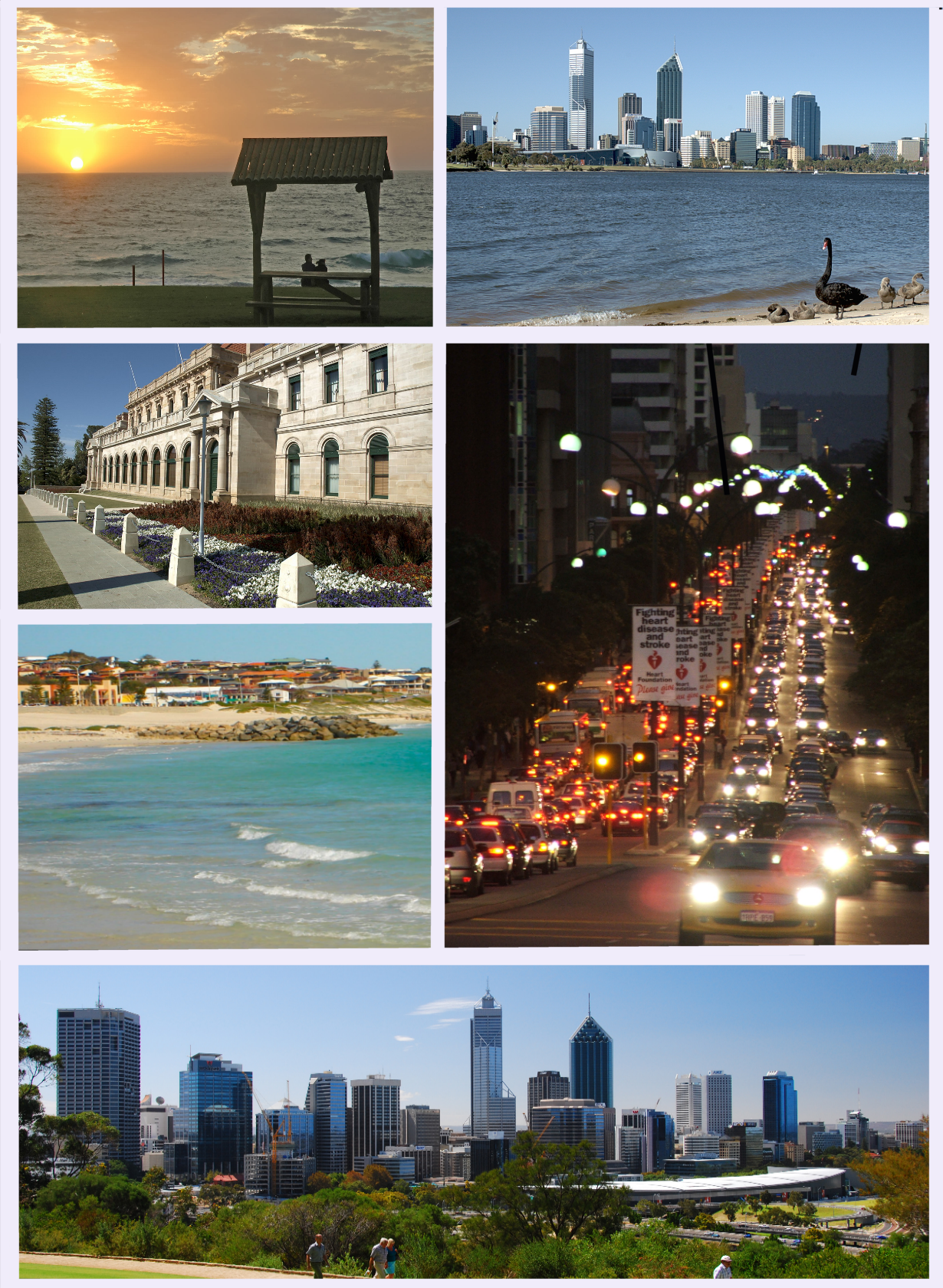
Perth, Australia. Courtesy of Wikipedia.
Home to over 1.6 million people, Perth is the capital of and largest city in the state of Western Australia. A few facts about Perth:
- Time zone: Australian Western Standard Time (UTC+8)
- Elevation: Sea level
- Climate zone: Mediterranean (hot/dry summers, cool/wet winters)
- Average high temperature: 76 °F (24.5 °C)
- Average low temperature: 55 °F (12.7 °C)
- Record high temperature: 115 °F (46.2 °C)
- Record low temperature: 31 °F (-0.7 °C)
- Average annual precipitation: 33.6 inches (852.6 mm)
Recent weather: Late Monday afternoon (March 22), Perth was hit by several severe thunderstorms that brought golfball-sized hail (1.75-inch-diameter), heavy rain, flooding, landslides, lightning, and wind gusts of over 75 mph. Damage from the storms is estimated at $100 million. Perth receives on average about 0.8 inches of rain in the month of March, and almost all of this rain fell in less than 10 minutes yesterday. A total of 1.6 inches of rain fell in the afternoon and evening.
A low-pressure trough came ashore in the afternoon, sparking the formation of several strong thunderstorms (see radar images, below, from the Bureau of Meteorology).
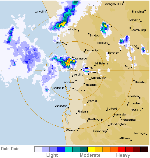
Perth radar at 0750UTC on 22 March 2010 (3:50 pm local time).
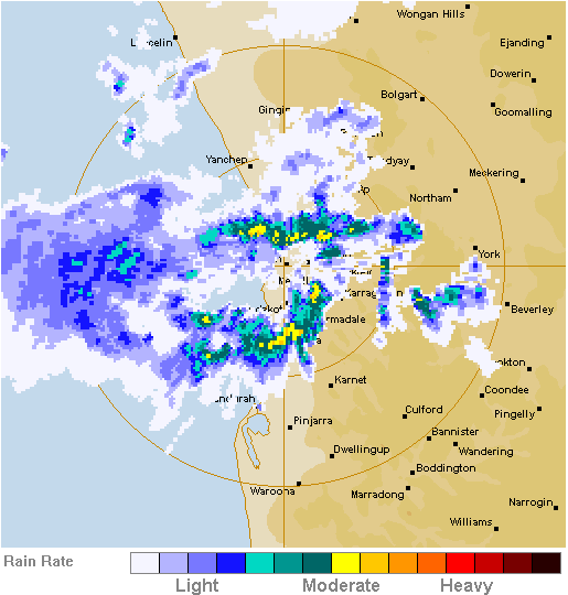
Perth radar at 0850UTC on 22 March 2010 (4:50 pm local time).
Forecast weather: High pressure is headed for the West Coast of Australia, so warm and dry conditions are expected to persist in Perth throughout this week. According to the Bureau of Meteorology, highs are forecast to range from near 84 °F to 90 °F under mostly sunny skies, with lows ranging from 57 °F to 66 °F.
For more information on Perth, here’s a link to Wikipedia.
For more information on the recent severe thunderstorms, here’s a BBC news article, and here’s a news article from The West Australian.
For weather maps and information on Perth weather, see the Australian Bureau of Meteorology.
Next week I’ll take a look at the climate and weather in another part of the globe. If you find these posts interesting or helpful, if you have suggestions, or if you have a city or country you’d like to recommend for next time, please leave a comment!
Permalink
« Previous Page — « Previous entries « Previous Page · Next Page » Next entries » — Next Page »


