03.20.10
Posted in Non-US Weather, Tropical Weather, Weather News at 12:37 pm by Rebekah
Severe Tropical Cyclone Ului made landfall in Queensland today (about 1:30am Sunday, local time), on the northeast coast of Australia. With a central pressure of 964 mb, the cyclone brought sustained winds of over 90 km/hr (56 mph) and wind gusts of 205 km/hr (128 mph) to the coast. According to the Australia Bureau of Meteorology, this is a Category 3 tropical cyclone. According to the National Hurricane Center in the US, this would only be a tropical storm. Why the large discrepancy in ratings?
Tropical cyclones have different names in different ocean basins; in the North Atlantic, a strong tropical cyclone is called a hurricane, while in the Northwest Pacific, a strong tropical cyclone is called a typhoon. Tropical cyclones also have different ratings in different ocean basins, each based on a set of criteria developed by the agency that monitors the storms in their particular region.
The table below (click to enlarge) shows worldwide ratings for tropical cyclones by ocean basin and agency (courtesy of Australia Severe Weather; they reportedly got it from Wikipedia).
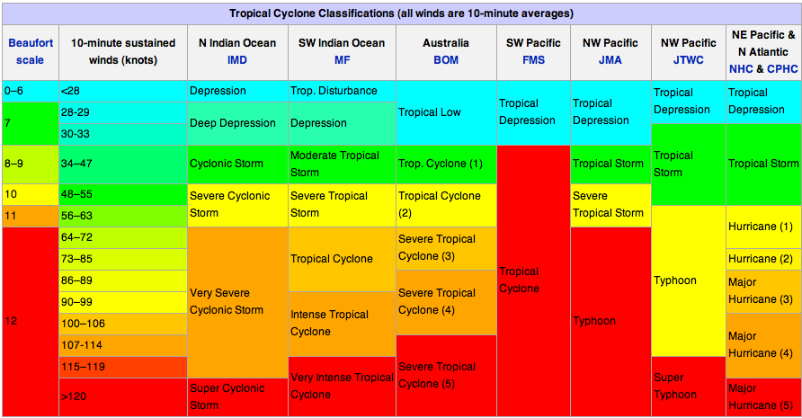
You may notice that the NHC ratings look a little different from what you may be used to. Note that these classifications are based on the 10-minute average wind speed in knots (1 knot = 1.15 mph), while the NHC’s Saffir-Simpson Scale is based on a 1-minute average wind speed…thus the wind speeds in this table have been “downgraded” to fit the 10-minute average that most everyone else in the world uses.
For more information on Australia’s particular rating system, see the Bureau of Meteorology page about tropical cyclones. For information on current tropical cyclones around Australia, see this Bureau of Meteorology page on tropical cyclones. For information on current tropical cyclones in the Pacific and Indian Ocean, see the Joint Typhoon Warning Center.
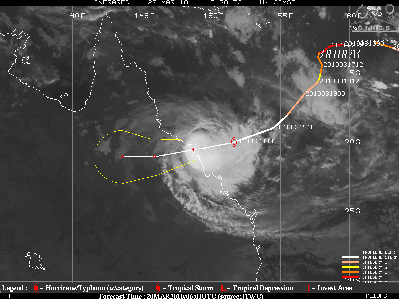
Severe Tropical Cyclone Ului at 1530UTC (2:30am local time in Queenland); infrared satellite image courtesy of the University of Wisconson-Madison.
Permalink
03.15.10
Posted in Non-US Weather, Weather News at 9:45 pm by Rebekah
Last Saturday, March 6th, several strong thunderstorms swept through Victoria, Australia (the southeast part of the country). The largest storm was a supercell, a rotating thunderstorm that pummeled Melbourne and surrounding areas with heavy rain and 1- to 4-inch hail.
Here’s a radar image, courtesy of the Australian Bureau of Meteorology, showing the line of thunderstorms at 0348Z, or 2:48pm local time (the southernmost cell is directly over Melbourne at this time):
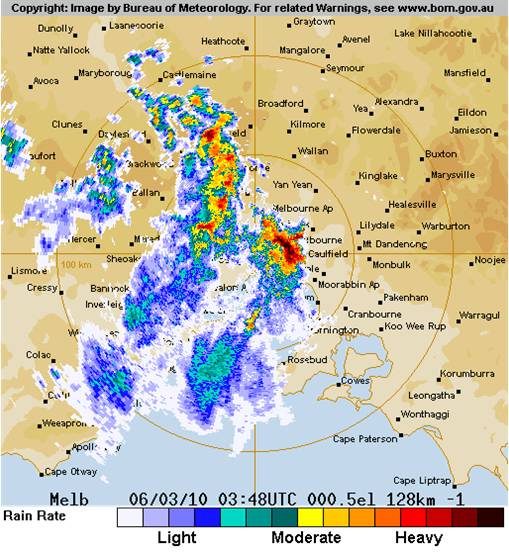
In the Melbourne metropolitan area, 1.8 inches (46 mm) of rain fell within 15 to 30 minutes, causing massive flooding. Here’s a video someone took of the hailstorm and the downpour.
2- to 4-cm hailstones were common across south Victoria. The largest hailstone was 10 cm (nearly 4 inches) in diameter.
Here’s another video (from an Australian news source) where the storm is described and shown.
The storms formed along a low pressure trough in southern Australia (see map below):
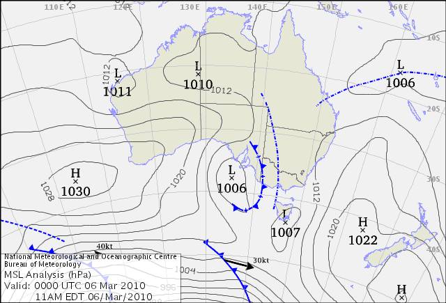
The Bureau of Meteorology has a great write-up on this here.
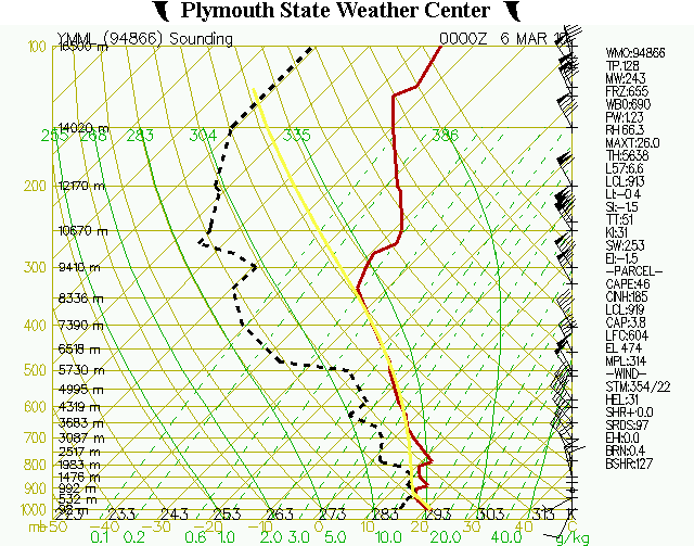
Finally, here’s a sounding taken from Melbourne at 00Z (11am local time), courtesy of the Plymouth State Weather Center, a few hours before the storms hit. It’s not a bad thunderstorm profile, but the instability could be greater…note than when the bold yellow line is to the right of the red line (temperature profile), that means that a rising parcel of air is warmer than the environment…so a lifted parcel would rise (unstable atmosphere)…
Permalink
02.16.10
Posted in Non-US Weather, Weather News at 12:15 am by Rebekah
Not to sound like a broken record, but while the southern US is enduring more cold air today and expecting more probably later on in this week or next, the northwestern US and much of Canada is enjoying (or not, if you’re an Olympic skier) record warm temperatures.
Vancouver’s normal temperature for today is 46.4 °F (8 °C). Any time you hear “normal” in reference to the weather or climate, that means the weather variable was averaged over a 30-year-period, currently 1971 to 2000. Today’s observed high was 54.3 °F (12.4 °C), only 0.4 °F (0.2 °C) below a record temperature!
Seattle is 3.8 °F warmer than normal this month. For the Ellensburg/Yakima area in central Washington, back where I grew up, the average monthly temperatures this year for January and February (so far) are 36.0 °F and 41.3 °F. Contrast that with the normal average temperatures for January and February: 29.8 °F and 36.0 °F (or even last year, 30.2 °F and 34.8 °F). It’s pretty clear to see that temperatures in the Northwest (and Canada) are well above normal this winter.
What’s in store for the next couple of weeks or so?
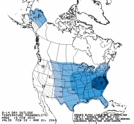
Below is an 8-14-day forecast temperature map of the US (from the Climate Prediction Center); blue shading indicates temperatures below normal. All I can say is it’s warmer in southern Alaska than it is here in Oklahoma.
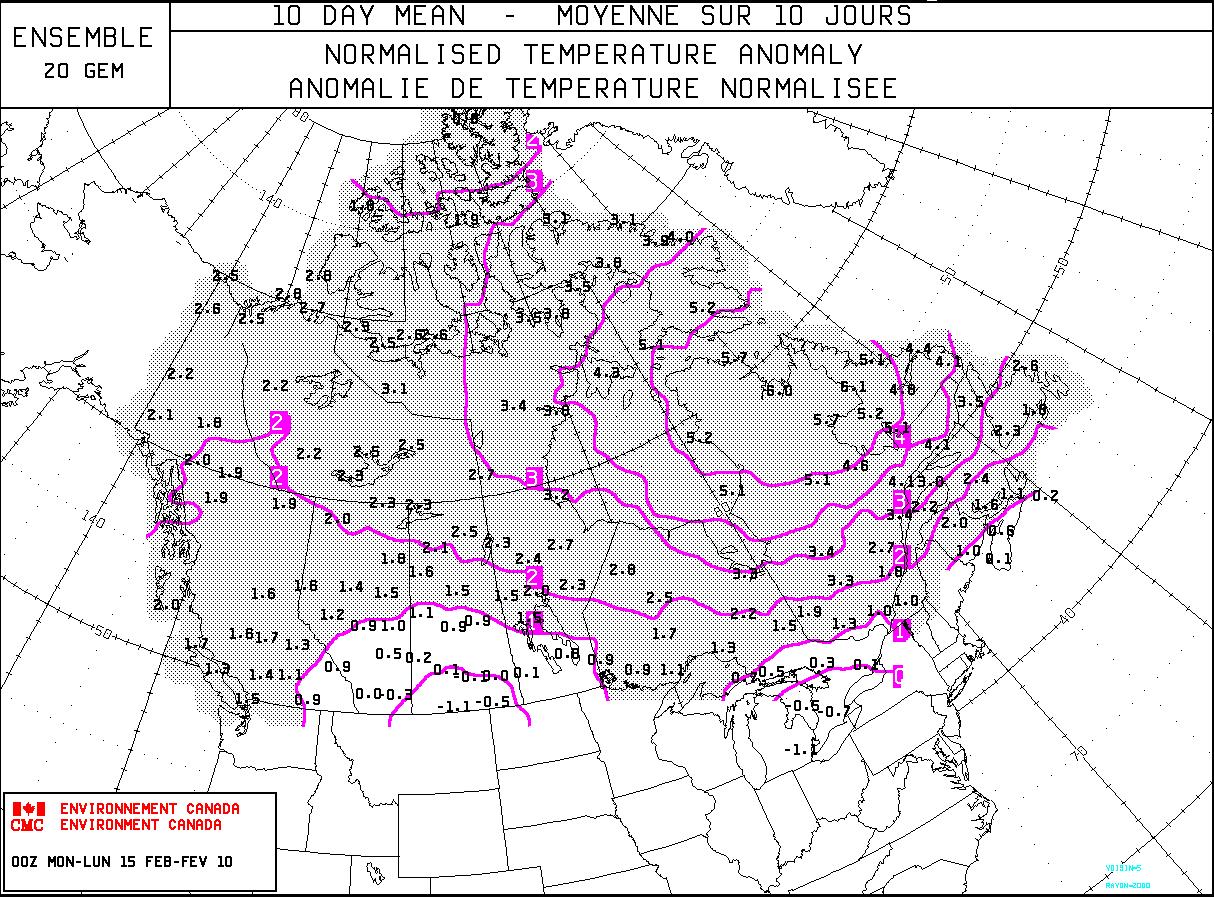
Below shows an updated map (click to enlarge) of Canada’s 10-day temperature outlook–what a surprise, more above-normal weather for the rest of the Olympics! Bad news for outdoor events at Cypress Mountain, near Vancouver…but the mountains around Whistler are at least experiencing record snowfall, ironically.
Permalink
02.12.10
Posted in Non-US Weather, Weather News at 9:37 pm by Rebekah
The winter Olympics began today in Vancouver and Whistler. The breath-taking shots of Canada and the Vancouver area that have been shown during the opening ceremonies tonight are beyond description. I miss the beauty of the Pacific Northwest so much; all the more so when I see such stunning images.
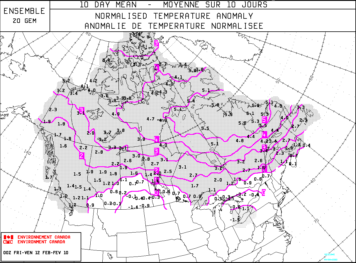
You may have heard that Vancouver is experiencing a warm and dry winter. However, on the up side, Whistler (where many of the outdoor events will take place) has already received record snowfall this year. What’s in store for the next two weeks of the Olympics? The following image shows a model forecast of Canada’s temperature anomaly (departure from normal, in degrees Celsius) over the next 10 days. As you can see, most of the country is experiencing and expecting above-normal temperatures!
So why has it been warm and dry in the North, but cold in the South and East? To continue from yesterday’s post, some of this has to do with El Niño. However, there are many other climate anomalies that affect temperature and precipitation patterns. One such anomaly is the North Atlantic Oscillation (NAO).
There is a semi-permanent low-pressure center near Iceland, called the Icelandic Low. There is also a semi-permanent high-pressure center near the Azores, called the Azores or Bermuda High. A positive NAO means both the high and the low are stronger, thus there is a stronger pressure gradient from high to low pressure. Storms tend to take a northwest track that bring warmer and wetter winters to northern Europe while eastern US winters tend to be mild.
A negative NAO means both the high and low are weaker (and sometimes shift their positions). Typical climate patterns include cold and dry winters in northern Europe and cold winters in the south central and eastern US. The following image is a graph of positive and negative NAOs.
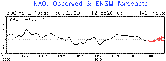
Note that during the cold stretch of weather in mid-December in the eastern two-thirds of the country, there was a moderately negative NAO. Also note that there was a moderately negative NAO during the cold period in early January. The red lines at the end of the graph show several models’ forecasts for the NAO phase–according to this, it looks like the cold weather may not yet be over, which agrees with model temperature forecasts for the next week and a half!
So cold plus moisture (remember El Niño) equals snow…which is what we’ve obviously been getting a lot of lately in the South and the East. In the meantime, the Northwest remains dry and mild. There is another climate anomaly that affect temperature and moisture in the Northwest, and it is called the Pacific Decadal Oscillation (PDO). Not much is known yet about the PDO, but we do notice that a negative PDO tends to bring colder temperatures and a positive PDO tends to bring warmer temperatures. We started the winter in a negative PDO, which was probably responsible in some part for the cold, snowy weather in the Northwest early in the winter. However, unfortunately for Vancouver, the PDO has gone back towards the neutral phase, thus the warming effects of El Niño are able to take over a little more.
There are some pretty amazing visual effects going on in the opening ceremony of the Olympics right now. The use of projectors to make the stadium look like ice or water or whales or whatever is pretty cool. Go US (and then Canada!)! 🙂
Permalink
« Previous Page « Previous Page Next entries »


