05.21.11
Posted in Non-US Weather, Weather News at 6:48 pm by Rebekah
Southern and eastern England has been unusually dry for the past several months. According to the Met Office, this past April was the 6th driest on record (back to 1910), the warmest, and the sunniest in the country.
The following maps from the Met Office show the actual rainfall and the rainfall anomaly for Great Britain in April (the last few months have also been dry).
Click to enlarge.
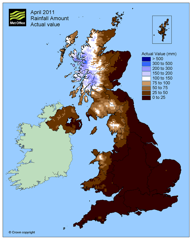
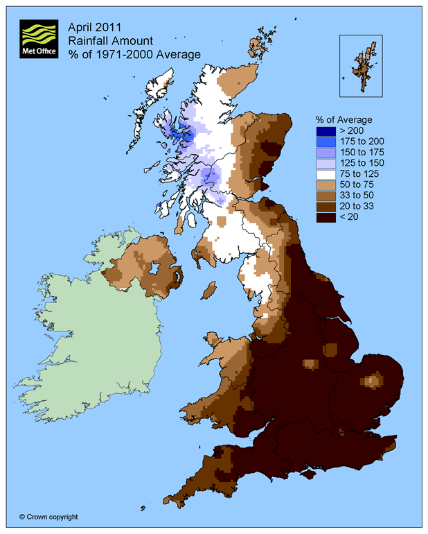
Permalink
05.10.11
Posted in Non-US Weather, Tropical Weather, Weather News at 8:00 am by Rebekah
This week’s post in the global weather and climate series features Kwajalein Island, part of the Kwajalein Atoll of the Republic of the Marshall Islands.
You may know by now that I recently accepted a job offer to work as a forecaster on Kwaj, as the locals call it. I’ll write a lot more about the island later, of course (see my new Kwaj blog here), but I thought I’d do a feature post on Kwaj before I even get there.
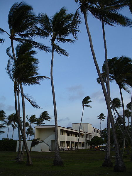
The Kwaj Lodge, for short-term housing but typical of housing on the island. From Wikipedia
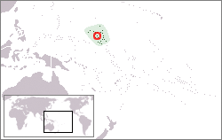
Map showing the location of Kwajalein Atoll, from Wikipedia
Kwajalein Island is a small island on the southern end of the Kwajalein Atoll. An atoll is a series of islands on a coral reef that surrounds a lagoon. Again, I’ll write more on all of this later.
Kwajalein Atoll is part of the Republic of the Marshall Islands, although Kwajalein Island is a U.S. Army base so there really are no locals on this island. The Marshall Islands are way out in the Pacific, and Kwajalein is just north of the equator and just west of the International Date Line.
Kwajalein has a long history, but in short, the Marshall Islands are Micronesian and were taken over by the Japanese some time in the early 1900s. The U.S. fought over (and won) Kwajalein during World War II, and today the island is an army missile testing site (from what I understand the island is sort-of “rented” out to the U.S., although there is much more to it than that).
A few more facts about Kwajalein (weather data from the RTS Weather Station, where I’ll be working):
- Time zone: UTC + 12
- Elevation: near sea level
- Climate zone: Tropical marine
- Average high temperature: 87 °F (30 °C)
- Average low temperature: 78 °F (25 °C)
- Average annual high/low temperature range: 86 to 87 °F (30 to 31 °C) / 78 °F (25 to 26 °C)
- Record high temperature: 97 °F (36 °C)
- Record low temperature: 68 °F (20 °C)
- Average annual rainfall: 80 inches (2,030 mm)
Weather: As you can tell by the statistics, Kwajalein does not have much of a temperature range; the island is typically warm and humid, and I hear there are two seasons: warm and wet, and warm and windy (trade winds).
I look forward to learning a lot more about the tropical weather of Kwajalein before and during my time there. I do know that the island is too close to the equator to get strong typhoons (tropical cyclones), although they may occasionally get sideswiped by weaker cyclones.
As to the weather this week…I’ll guess that highs will be around 86 °F and there may be a chance of thunderstorms! (Check the forecast…yep, that’s about right! Though I know there will be more to my job than just that… 🙂 )
For weather maps and information on current and forecast Kwajalein weather, see the RTS Weather Station, Weather Underground and Weather Online UK (global maps and models).
Here’s a Wikipedia link for Kwajalein Atoll, and here’s a Wikipedia link for the Republic of the Marshall Islands.
Next Tuesday I plan to take a look at the climate and weather in another part of the globe, hopefully just after witnessing a space shuttle launch! As always, if you have any suggestions for future cities, please leave a comment!
Permalink
04.19.11
Posted in Non-US Weather, Weather News at 8:00 am by Rebekah
This week’s post in the global weather and climate series features Hanga Roa, Easter Island.
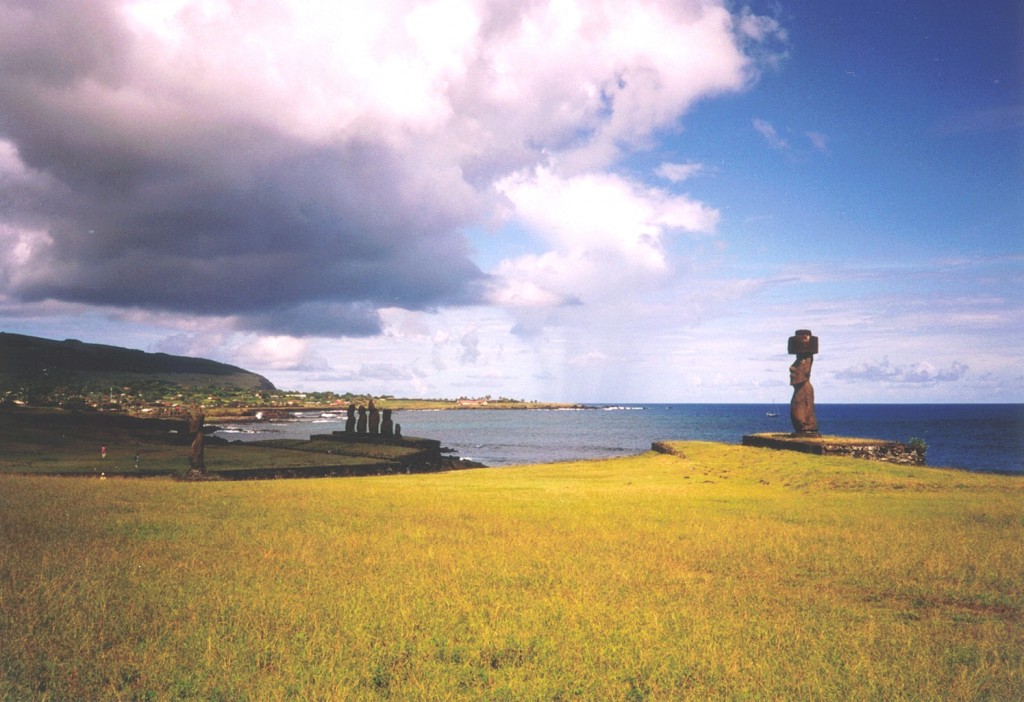
Hanga Roa, Easter Island, from Wikipedia
Hanga Roa (sometimes Hangaroa) is the main city and capital of Easter Island (aka Rapa Nui or Isla de Pascua), a territory of Chile. Easter Island is a small, Polynesian island in the southeastern Pacific Ocean, most famous for the monolithic human statues known as moai. The island got its name from the Dutch explorer Jacob Roggeveen, who on Easter Sunday 1722, became the first known European to land there.
Hanga Roa, on the southwest coast of Easter Island, is located at 27 °S. The island is nearly 1,300 miles east of Pitcairn Island, the nearest inhabited island, and nearly 2,200 miles east of Chile, making Easter Island one of the most isolated inhabited islands in the world. The population of Hanga Roa was 3,791 in 2002, making up 87% of the population of the entire island. Primary industries in the city include tourism, fishing, and farming. There is also an airport (the only airport on the island) and a multi-use stadium, home to the island’s football team.
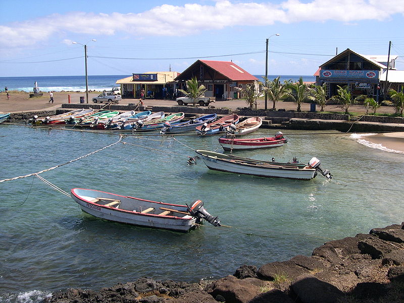
Hanga Roa harbor, from Wikipedia
A few more facts about Hanga Roa (from Wikipedia):
- Time zone: Standard Time (UTC – 6) or Daylight Saving Time (UTC – 5)
- Elevation: varies…begins at sea level, weather station at 167 ft (51 m)
- Climate zone: Humid subtropical
- Average high temperature: 73 °F (23 °C)
- Average low temperature: 66 °F (19 °C)
- Average annual high/low temperature range: 68 to 79 °F (20 to 26 °C) / 61 to 71 °F (16 to 21 °C)
- Average annual rainfall: 44 inches (1,125 mm)
Weather: Thanks to Hanga Roa’s location in the subtropics and on the coast of a small island, the temperature stays mild and fairly constant throughout the year. Precipitation is ample, but not as high as on islands in the southwestern Pacific.
Currently in the southern hemisphere fall, Hanga Roa is expecting highs around 77 °F, lows around 68 °F, and a slight chance of rain every day this week (personally, I think that might get a little boring after a while…but it could be a nice place to visit).
For weather maps and information on current and forecast Hanga Roa and Easter Island weather, see the Dirección Meteorológica de Chile, Weather Underground and Weather Online UK (global maps and models).
Here’s a Wikipedia link for Hanga Roa, and here’s a Wikipedia link for Easter Island.
Next Tuesday I may take a look at the climate and weather in another part of the globe, but I will be on my way down to Florida for the space shuttle Endeavour’s launch, so I might put the series on hold for another week or two. As always, if you have any suggestions for future cities, please leave a comment!
Permalink
04.12.11
Posted in Non-US Weather, Weather News at 8:00 am by Rebekah
This week’s post in the global weather and climate series features Alice Springs, Northern Territory, Australia.
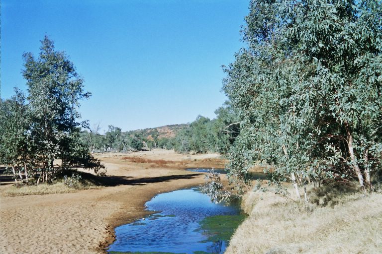
The springs that gave Alice Springs its name, from Wikipedia
Alice Springs is in the south central Northern Territory, near the center of Australia. This arid town is situated on the northern side of the MacDonell Ranges, a 400-mile-long series of mountain ranges in central Australia (the tallest is just over 5,000 feet).
Aborigines first came to this area thousands of years ago. Europeans began to settle in Alice Springs by the late 19th century, with the construction of a telegraph line and the discovery of gold. Until 1933, the town was known as Stuart (named for the first European to travel from southern to northern Australia).
Today, Alice Springs is home to nearly 28,000 people, and is primarily dependent on tourism.
Alice Springs hosts a number of sporting events, including the world’s only dry river race. The Henley-on-Todd Regatta, also known as the Todd River Race, is a race with bottomless boats in the sandy, dry riverbed of the Todd River (you HAVE to check out that webpage, it’s so interestingly bizarre). “Boats” are made of anything anyone can find, from metal frames with advertisements to washtubs to giant hamster wheels. Residents first came up with the idea to playfully mock the original British settlers and the British boat races, most notably the Henley Royal Regatta at Henley-on-Thames, England. In 1993, the Henley-on-Todd Regatta had to be cancelled, as there was actually water in the riverbed!

Henley-on-Todd Regatta, Alice Springs, from OzOutback
Another unique event is the Camel Cup, which consists of a series of races using camels instead of horses.
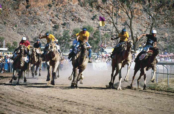
The Alice Springs Camel Cup, from Wikipedia
A few more facts about Alice Springs (from Wikipedia):
- Time zone: Australian Central Standard Time (UTC+9:30)
- Average elevation: 1,791 ft (545 m)
- Climate zone: Desert
- Average high temperature: 84 °F (29 °C)
- Average low temperature: 56 °F (13 °C)
- Average annual high/low temperature range: 68 to 98 °F (20 to 36 °C) / 39 to 71 °F (4 to 21 °C)
- Record high temperature: 113 °F (45 °C)
- Record low temperature: 19 °F (-8 °C)
- Average annual rainfall: 11 inches (282 mm)

Panorama of Alice Springs, from Wikipedia
Weather: Currently there is not much going on over central Australia weatherwise, except for a trough that should come through on Thursday and bring some clouds and cooler temperatures (but not rain). Alice Springs is pretty dry year-round, but southern winters are especially dry in this region.
This week the high temperatures are warming up from the lower 70s to the upper 80s by Thursday, before the trough arrives and pushes the highs back to the upper 70s by the weekend.
For weather maps and information on current and forecast Alice Springs and Australian weather, see the Australian Bureau of Meteorology, Weather Underground and Weather Online UK (global maps and models).
For a bit more information on Alice Springs, here’s a link to Wikipedia.
Next Tuesday I plan to take a look at the climate and weather in another part of the globe. As always, if you have any suggestions for future cities, please leave a comment!
Permalink
03.29.11
Posted in Non-US Weather, Weather News at 8:00 am by Rebekah
This week’s post in the global weather and climate series features Nairobi, Kenya.
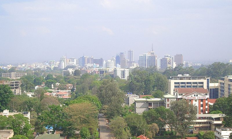
Nairobi skyline, from Wikipedia
Nairobi, just south of the equator, lies on the Nairobi River in south central Kenya. Kenya borders Lake Victoria and the Indian Ocean. Founded as a rail depot in 1899, Nairobi quickly grew and became the capital of British East Africa in 1907.
Today, Nairobi is the capital of and largest city in Kenya, as well as the largest city in east Africa. The population (2009 census) is 3.1 million. Well off financially, Nairobi welcomes many tourists each year. The primary tourist destination is the Nairobi National Park, including giraffes, lions, and rhinos. Nicknames for the city include “The Green City in the Sun” (from the vegetation and warm climate) and “Safari Capital of the World” (from the popular safari tourism).
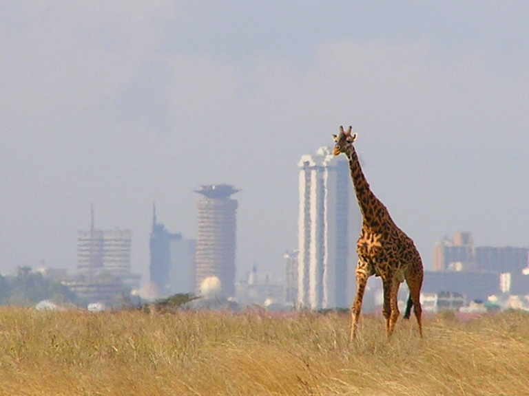
A giraffe in Nairobi National Park, bordering the city of Nairobi in the background. From Wikipedia
A few more facts about Nairobi (from Wikipedia):
- Time zone: East Africa Time (UTC+3)
- Average elevation: 5,450 ft (1,661 m)
- Climate zone: Subtropical highland
- Average high temperature: 74 °F (23 °C)
- Average low temperature: 54 °F (12 °C)
- Average annual high/low temperature range: 69 to 78 °F (21 to 26 °C) / 50 to 57 °F (10 to 14 °C)
- Average annual precipitation: 40 inches (1,024 mm)
Weather: As Nairobi is near the equator, the city experiences fairly warm daytime temperatures throughout the year. However, the city is over a mile above sea level, so nights can be quite cool.
The rainiest months of the year are March through May and November through December.On average, the months of July and August each receive less than one inch of rain.
We’re going into the wettest month; April receives, on average, 8.6 inches of rain over 16 rainy days.
This week is forecast to be especially warm for the area, with highs in the low 80s and lows near 60 °F. Rain is in the forecast for Tuesday through Thursday (it has already been raining there for at least the past week).
For weather maps and information on current and forecast Nairobi and Kenya weather, see the Kenya Meteorological Department, Weather Underground and Weather Online UK (global maps and models).
For a bit more information on Nairobi, here’s a link to Wikipedia.
Next Tuesday I plan to take a look at the climate and weather in another part of the globe. As always, if you have any suggestions for future cities, please leave a comment!
Permalink
« Previous Page — « Previous entries « Previous Page · Next Page » Next entries » — Next Page »


