02.01.11
Posted in Non-US Weather, Tropical Weather, Weather News at 8:00 am by Rebekah
This week’s post in the global weather and climate series features Cairns, Queensland, Australia.
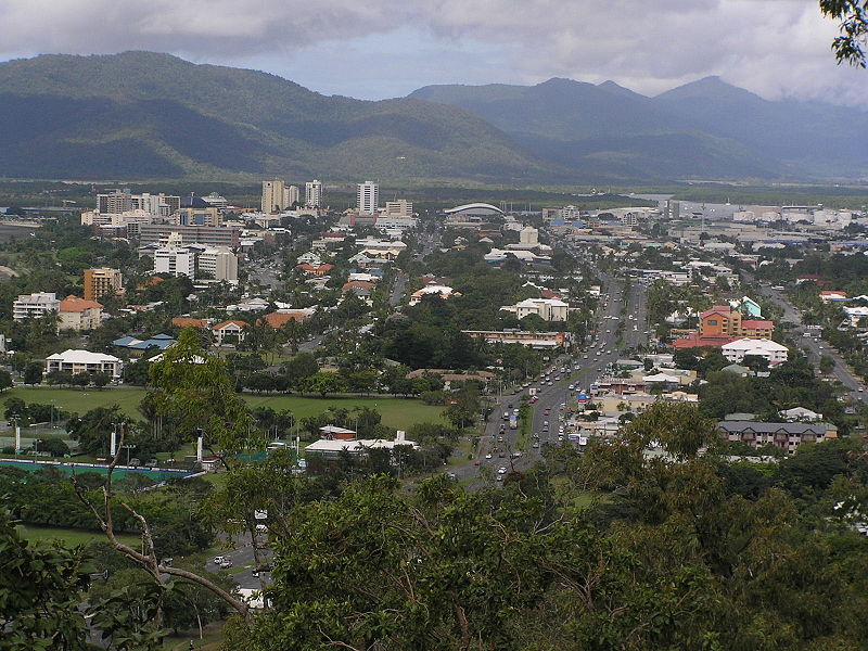
Cairns, from Mt. Whitfield, looking east. From Wikipedia
Cairns is situated on the northeastern coast of Queensland, on the eastern side of the Cape York Peninsula. The Great Dividing Range is to the west, and the Great Barrier Reef is just off the coast. Cairns is home to over 164,000 people.
Cairns was founded in 1876, and was later used by the Allied Forces during World War II as a base for Pacific operations. Today, the city is an important international tourism destination. Following Sydney, Melbourne, and Brisbane, Cairns is the fourth-most popular destination in Australia for foreign tourists.
A few more facts about Cairns (from Wikipedia):
- Time zone: Australian Eastern Standard Time (UTC+10)
- Average elevation: sea level
- Climate zone: Tropical monsoon
- Average high temperature: 84 °F (29 °C)
- Average low temperature: 69 °F (21 °C)
- Average annual high/low temperature range: 78 to 89 °F (26 to 31 °C) / 63 to 75 °F (17 to 24 °C)
- Average annual precipitation: 79 inches (2,011 mm)
Weather: February is climatologically the wettest month of the year for Cairns. The city’s monsoon climate means that there is a very pronounced wet season in the summer, with a dry season in the winter.
While not as affected by the Australian flooding as some points further south, Cairns has received copious precipitation recently. The rain is not going to stop any time soon, unfortunately; there is a chance of showers and thunderstorms every day and night for the next week or so, and Tropical Cyclone Yasi could bring as much as a foot or more of rain for some places around and just east of Cairns.
Models show Yasi could stall a bit in the mountains for about 12 hours or so after making landfall, bringing greater chances for large rain totals. Cairns will also get some strong winds (maximum winds could reach 100 mph, with higher gusts) from Yasi, as the cyclone is expected to make landfall as a Category 4.
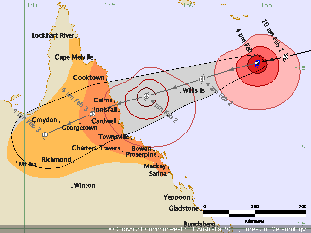
See also yesterday’s post, Strengthening Tropical Cyclone Yasi.
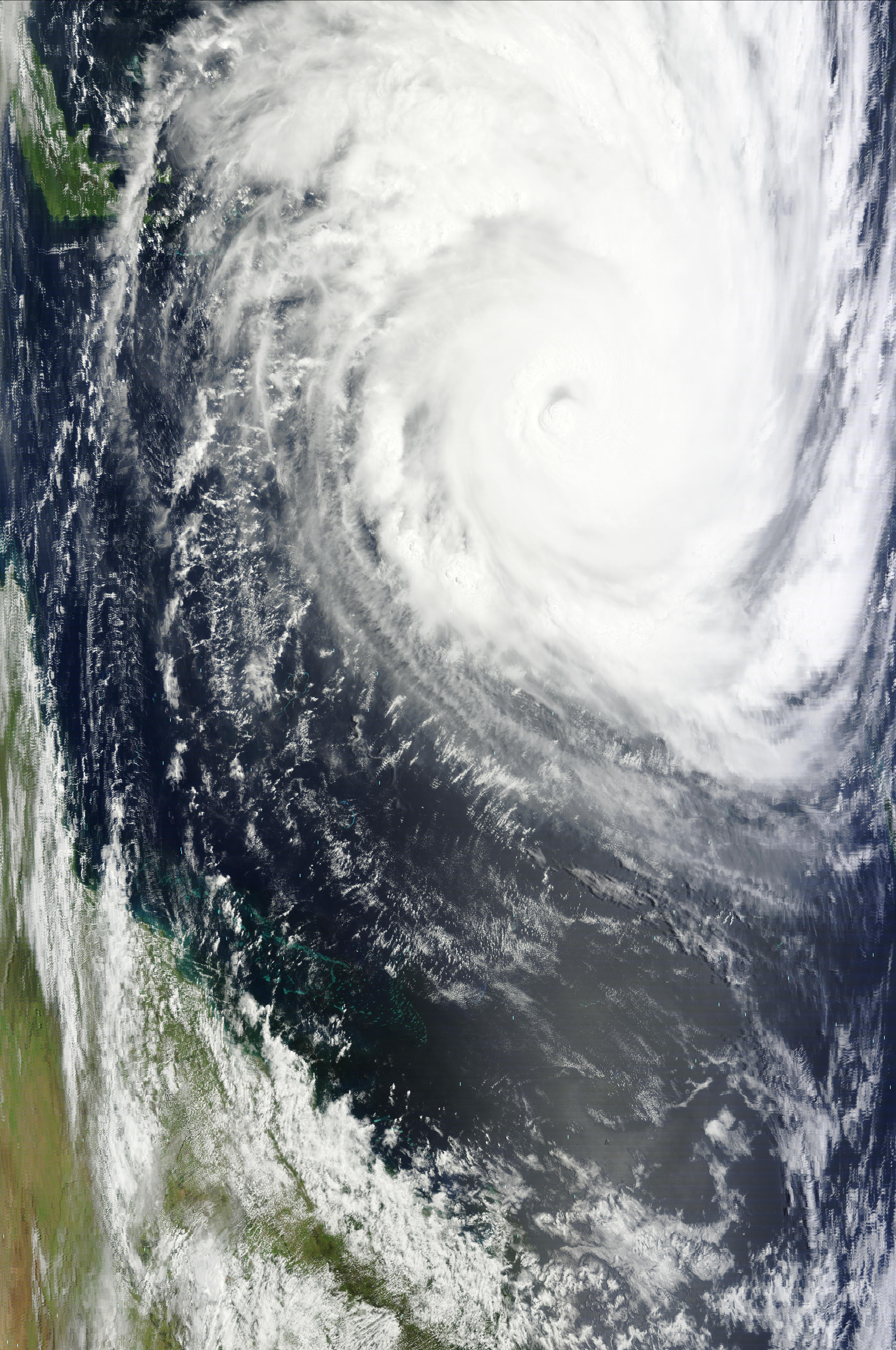
Tropical Cyclone Yasi, at 00Z (10am on the 1st, Australian Eastern Standard Time), from MODIS (click to enlarge)
For the latest on Tropical Cyclone Yasi, see the Australian Bureau of Meteorology.
For weather maps and information on current and forecast Cairns weather, see the Australian Bureau of Meteorology, Weatherzone, Weather Underground, and Weather Online UK.
For more information on Cairns, here’s a link to Wikipedia.
Next Tuesday I plan to take a look at the climate and weather in another part of the globe. As always, if you have any suggestions for future cities, please leave a comment!
Permalink
01.31.11
Posted in Non-US Weather, Tropical Weather at 2:47 pm by Rebekah
Yesterday I posted forecasts for a new tropical cyclone, Yasi, that had formed near Vanuatu. Yasi has strengthened considerably over the past 12 or so hours, and is currently a Category 3 severe tropical cyclone on the Australian scale (Category 2 on the Saffir-Simpson scale), with a maximum 10-minute wind speed of 98 mph (156 kph) and a minimum pressure of 960 mb. Maximum wind gusts are estimated to be near 138 mph (221 kph). Yasi is moving westward at 25 mph (40 kph).
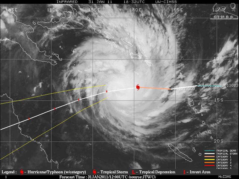
Infrared satellite image of Yasi at 1830 Z (4:30 am Australian Eastern Standard Time), from UW-CIMSS (see this website for the latest data such as sea-surface temperatures, wind shear, satellite images, etc.)
Yasi’s track has shifted a bit further north, so the tropical cyclone is now forecast to make landfall Wednesday night / Thursday morning (Australian time) near Cairns/Innisfail, Queensland. Yasi is over some pretty warm waters and a low shear environment (see this blog post for info on how tropical cyclones form and strengthen), so more strengthening is expected.
The Australian Bureau of Meteorology is calling for Yasi to peak in strength late Wednesday afternoon (Australian time) as a Category 4 cyclone (on both the Australian and the Saffir-Simpson scales) with maximum sustained winds of 121 mph (193 kph) and a minimum central pressure of 939 mb. The cyclone may weaken just a bit before making landfall, but it is likely that it will make landfall as a Category 4 storm.
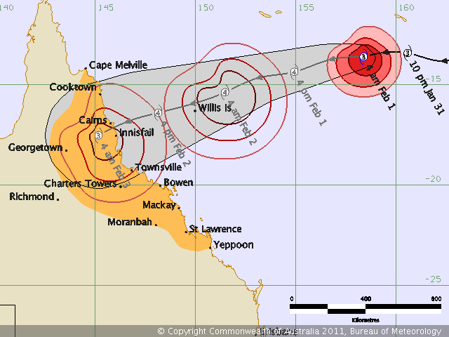
Yasi’s forecast strength and track, issued by the Bureau of Meteorology at 4 am Australian Eastern Standard Time
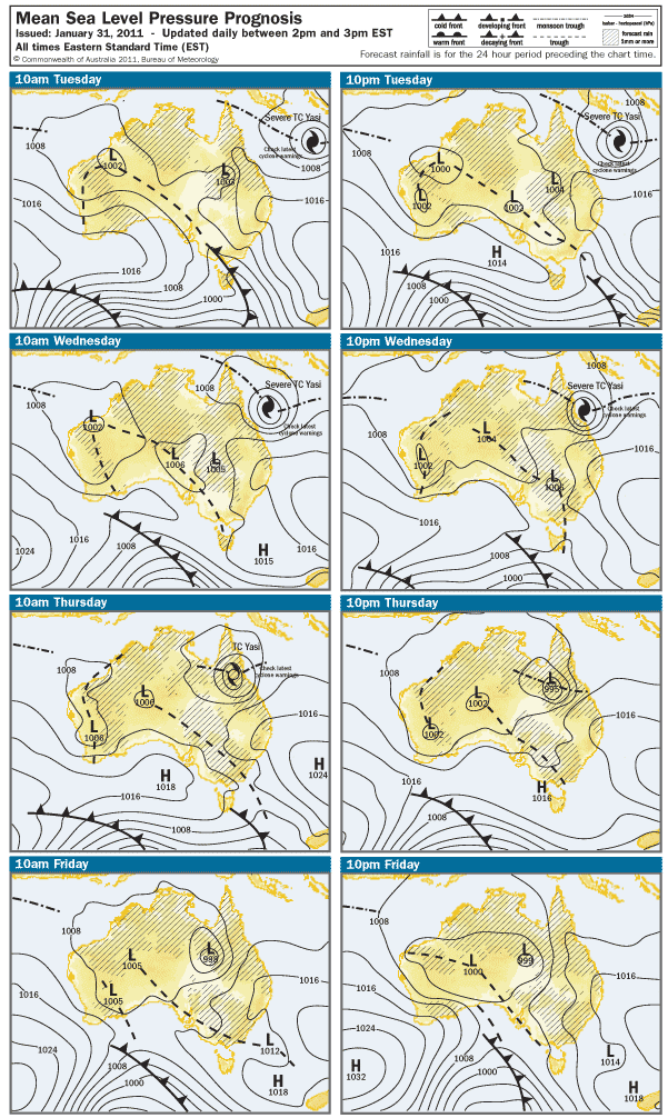
Surface map forecast for the next few days, from the Bureau of Meteorology
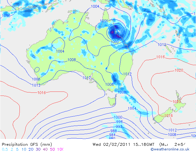
GFS model’s 12Z run (valid at 18Z Wednesday, or 4 am Thursday, Australian Eastern Standard Time), showing a more southern track, more towards Townsville (map from Weather Online UK):
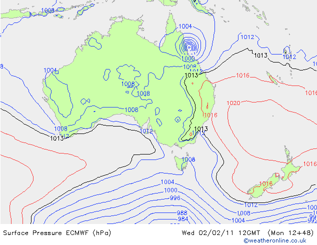
ECMWF model’s 12 run (valid at 12Z Wednesday, or 10 pm, Australian Eastern Standard Time), from Weather Online UK:
To keep up-to-date with the Bureau of Meteorology’s latest forecast tracks and tropical cyclone advice, see the tropical cyclone section of their webpage. Another good website with tropical cyclone tracks and information, that I have yet to mention, is Weather Underground.
Permalink
01.30.11
Posted in Non-US Weather, Tropical Weather, Weather Forecast at 1:46 pm by Rebekah
As if Queensland hasn’t already seen enough rain and flooding to last a lifetime, a new tropical cyclone is forming in the southeast Pacific, and models show it strengthening to possibly a Category 3 (Australian) cyclone (probably only Cat. 1 on the Saffir-Simpson scale) just before making landfall somewhere near or south of Townsville, Queensland on Thursday.
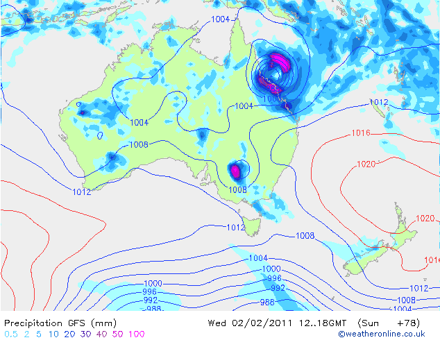
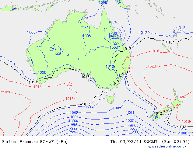
This tropical cyclone, Yasi (on the Fiji names list), may bring 70+ mph (110+ kph) winds and heavy rain when it makes landfall. The GFS model is currently predicting a minimum pressure of 976 mb, while the ECMWF is predicting a minimum pressure of 972 mb, with a slightly faster track.
Here’s the GFS model’s forecast (from Weather Online UK) for surface pressure and precipitation, at 18Z on Wednesday (4 am Thursday, local time)…the cyclone is predicted to make landfall about 6 hours later:
Here’s an ECMWF forecast for surface pressure, for comparison…the nearest time they have is for Thursday at 00Z (10 am Thursday, local time):
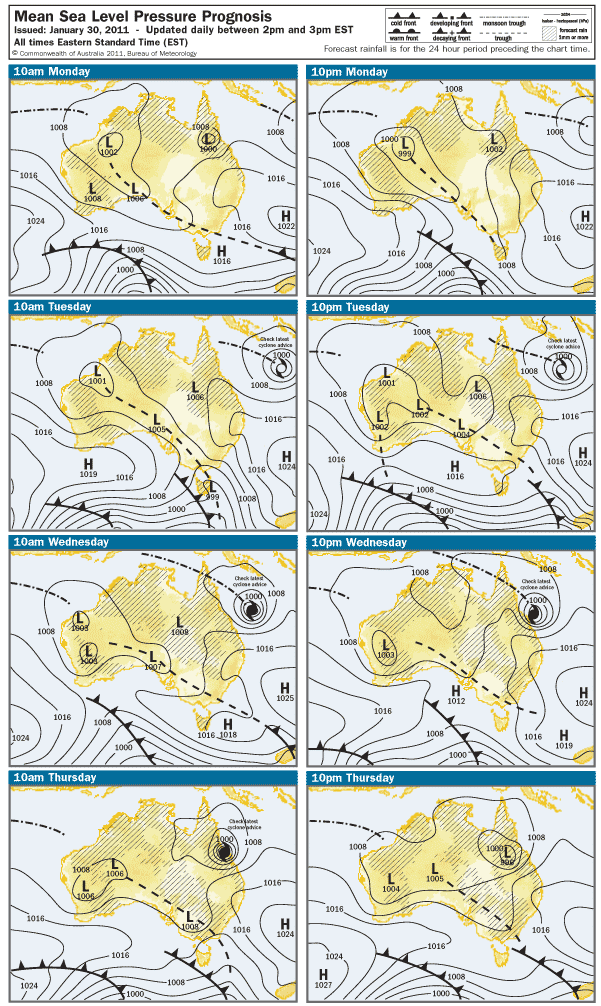
Here’s what the Australian Bureau of Meteorology is predicting for the next few days (for those of you in the U.S., the local “Eastern Standard Time” on this map is 15 hours ahead of the U.S. Eastern Standard Time):
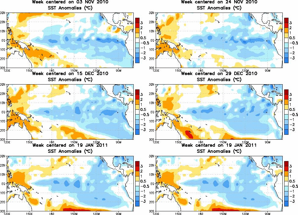
Waters off the eastern coast of Queensland are warmer-than-normal, aiding in the strengthening of Yasi just before landfall.
Tropical sea-surface temperature anomalies, from the Climate Prediction Center:
Here’s another link, from NCDC, showing sea-surface temperature anomalies across the entire globe over the past 5 weeks.
Permalink
01.29.11
Posted in Non-US Weather, Tropical Weather, Weather News at 8:00 am by Rebekah
Severe Tropical Cyclone Bianca, a weakening Category 3 tropical cyclone on the Australian rating system (Category 1 on the Saffir-Simpson Scale), has been taking a very strange trek along the western coast of Australia.
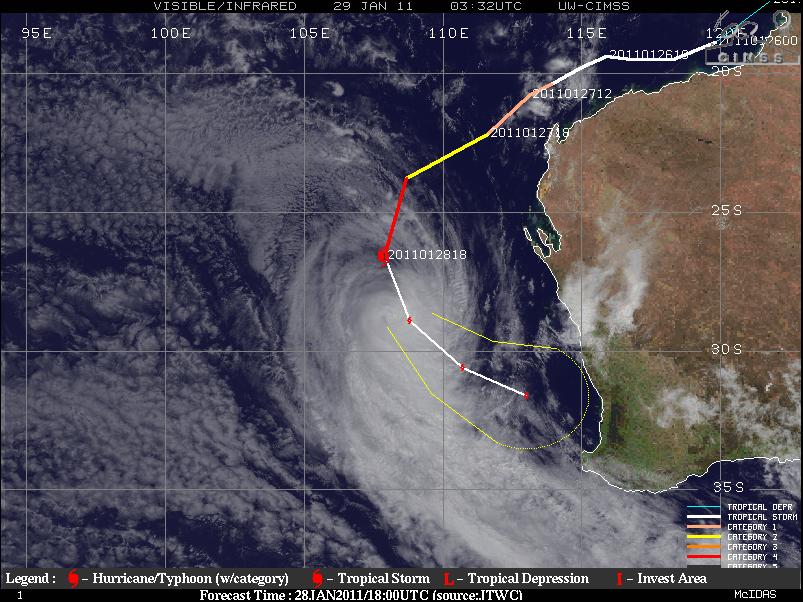
Satellite image, history, and forecast track of Bianca along Australia’s west coast. Source: CIMSS
Note how Bianca formed off the northwestern coast of Australia and proceeded to move almost parallel to the coast, all the way down to the southwestern coast, where the cyclone is expected to make landfall on Sunday.
Bianca’s maximum sustained winds are about 75 to 85 mph, but she is expected to keep weakening as she encounters cooler water temperatures and increased wind shear. The center of the cyclone is forecast to make landfall just south of Perth as a weak Aus. Cat. 1 (tropical storm on the SS-scale) or tropical low (tropical depression). Primary threats to the coast will be rough seas, heavy rainfall with possibly some localized flooding, and strong wind gusts up to about 60 mph.
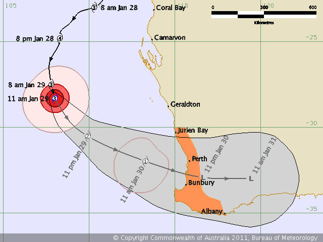
Bianca’s history and forecast track, as of Saturday morning Australian Western Standard Time, from the Australian Bureau of Meteorology
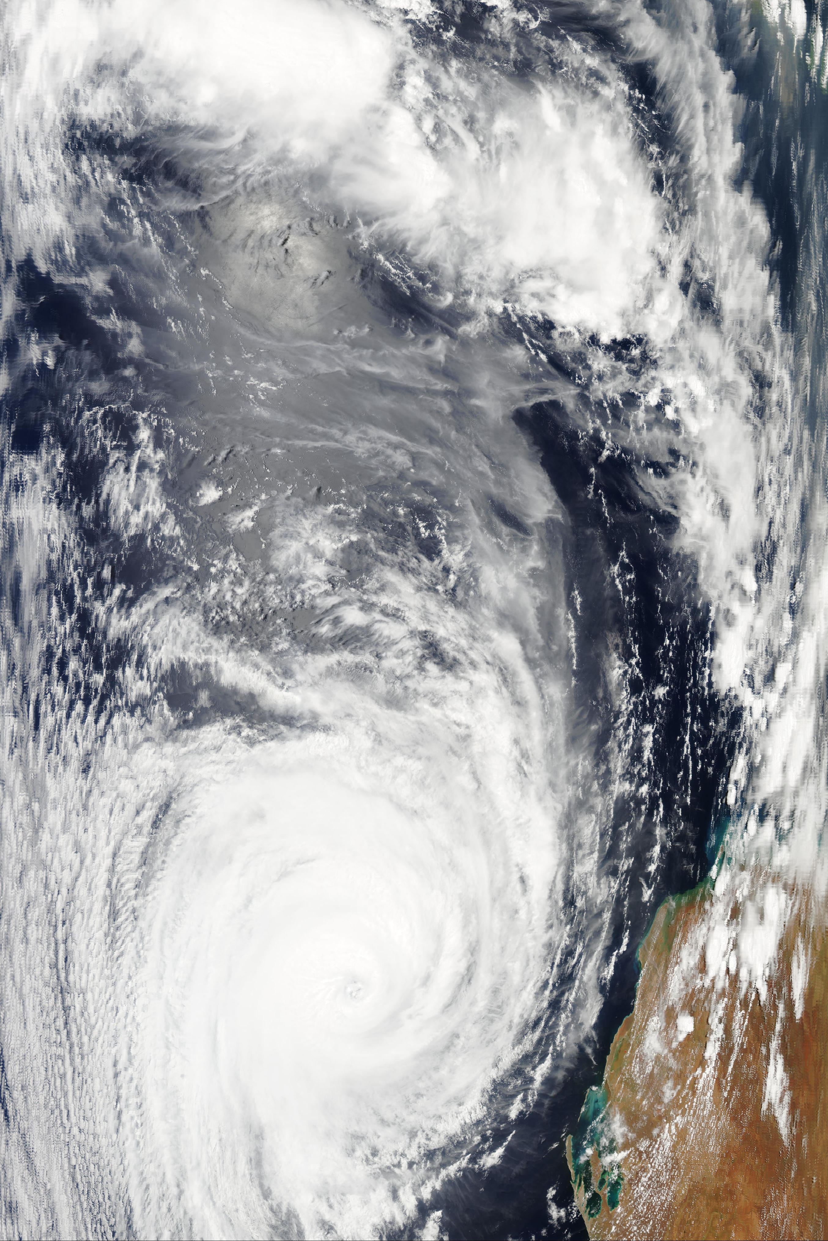
Bianca (click to enlarge), at 6:30 UTC on the 28th, via NASA’s Aqua/MODIS satellite (looks more impressive than the more recent image from early on the 29th…go to the “real-time” tab to see the latest images)
As a follow up to my post on Severe Tropical Cyclone Wilma the other day, Wilma is now only a shadow of her former self…the cyclone brushed past the northern coast of New Zealand, and now is just a low falling apart southeast of New Zealand.
For the latest on Tropical Cyclone Bianca, check out the Australian Bureau of Meteorology, Weather Underground, and CIMSS. To learn about tropical cyclone ratings in different ocean basins, check out the chart on this older blog post of mine.
Permalink
01.27.11
Posted in Non-US Weather, Tropical Weather, Weather News at 8:00 am by Rebekah
Severe Tropical Cyclone Wilma, the equivalent of a Category 3 (borderline Category 4) hurricane (as of Wednesday night) on the Saffir-Simpson scale, is about a thousand miles north of the northern island of New Zealand. As of Wednesday night, Wilma’s maximum winds were estimated at 130 mph (gusts to 160 mph). The tropical cyclone is moving west-southwest at about 13 mph, and is expected to make a gradual turn on Friday and may brush the northern coast of the northern island of New Zealand as a tropical storm on Saturday (if she holds together that long).
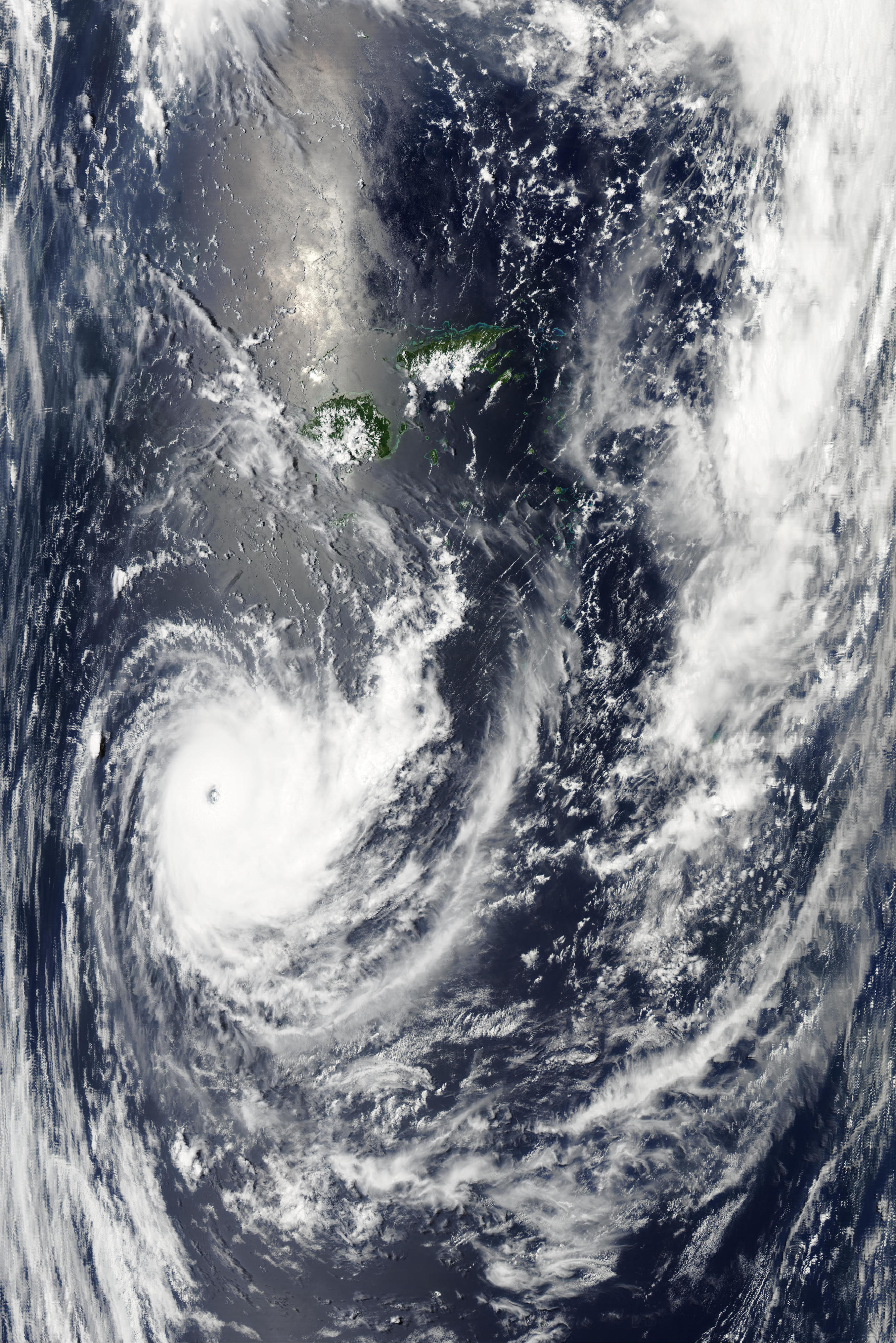
Aqua/MODIS image of Tropical Cyclone Wilma at 01:45 UTC…to zoom in to as much as 250 m resolution, see the NASA MODIS website, scroll down to the Aqua images from the 26th, and look towards the bottom right for 01:45 UTC.
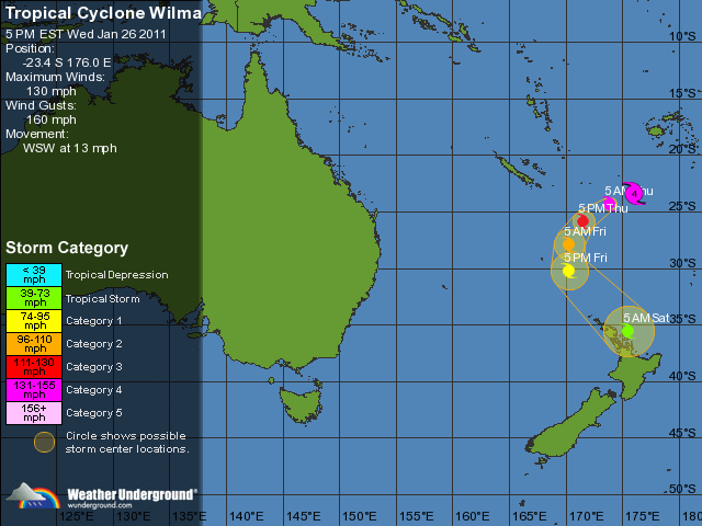
Wilma’s forecast track via Weather Underground
Permalink
« Previous Page — « Previous entries « Previous Page · Next Page » Next entries » — Next Page »


