01.26.11
Posted in Non-US Weather, Weather News at 8:00 am by Rebekah
There are a lot of places around the world that have been flooding lately; here’s a list of some of them, based on a photo gallery from The Guardian:
- Eastern Australia – the floodwaters are not just affecting Queensland but Victoria now as well
- Southern Philippines (Davao del Sur province, on the southern island of Mindanao) – flooding following weeks of heavy rain
- Southern Thailand – another case of heavy rain causing flooding
- Sri Lanka – more rain fell in some areas from early December to mid-January than typically falls in a year
- South Africa – rivers have risen to great heights and flooded a number of areas
- Poland – flooding from snow melt
- Southern Sweden – recent heavy snow melt
- Belgium – flooding from rain and snow melt
- Netherlands – more rain and melting snow
- Central Germany – massive flooding caused by melting snow; barge supplies going to Frankfurt airport via the Rhine River have been stopped, causing more problems
- Northern France – rain and melting snow again
- East Central Scotland – heavy rain and melting snow causing some major flooding
- Southeastern Brazil – severe flooding caused mudslides that killed hundreds of people
- Northern Colombia – unusually heavy rains have caused river levels to rise
- Western Washington – heavy rains in the Pacific Northwest have caused some flooding off and on this winter
In addition to The Guardian‘s photo gallery, I found a photo gallery on the New York Post website.
Permalink
01.25.11
Posted in Non-US Weather, Weather News at 8:00 am by Rebekah
This week’s post in the global weather and climate series features Istanbul, Turkey.
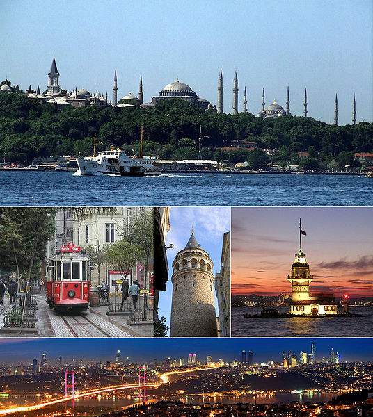
Montage of Istanbul, Turkey. Source: Wikipedia
Istanbul, formerly known as Byzantium and Constantinople, is situated on the Bosphorus Strait that runs from the Sea of Marmara to the Black Sea. The Bosphorus divides the city into a European and an Asian side, making Istanbul the only bi-continental city in the world. Istanbul also sits near the North Anatolian Fault, the boundary between the African and Eurasian plates. This fault has been responsible for several major earthquakes, including one in 1999 that killed over 17,000 people in and around Istanbul.
Istanbul’s rich history can be traced back to at least the 7th century BC. Istanbul, like Rome, has been called “The City of Seven Hills”, as the oldest part of the city is built on seven hills, each of which bears a historic, imperial mosque.
Istanbul and the surrounding area produce cotton, fruit, olive oil, silk, and tobacco. The city is the economic center of Turkey and an important city in the global economy. According to Forbes magazine, as of March 2008, Istanbul had 35 billionaires, ranking 4th in the world. With a population of about 12.8 million, Istanbul is the largest city in Turkey and the 5th largest city proper in the world.
A few more facts about Istanbul:
- Time zone: Eastern European Time (UTC+2) or Eastern European Summer Time (UTC+3)
- Average elevation: 121 feet (37 meters)
- Climate zone: Mediterranean
- Average high temperature: 66 °F (19 °C)
- Average low temperature: 51 °F (11 °C)
- Average annual high/low temperature range: 48 to 83 °F (9 to 29 °C) / 37 to 66 °F (3 to 19 °C)
- Average annual precipitation: 33 inches (844 mm)
Weather: It’s currently rainy and cool in Istanbul, with highs in the 40s and lows in the 30s. There is a trough over eastern Europe right now, with a surface low just southwest of Istanbul. This low will move up over Turkey, bringing a continued chance for rain.
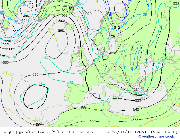
500mb height and temperature forecast (initialized at 18Z on Monday) for Europe at 12Z, from Weather Online UK
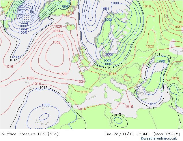
Surface pressure forecast (initialized at 18Z on Monday) for Europe at 12Z, from Weather Online UK
For weather maps and information on current and forecast Istanbul weather, see the Turkish State Meteorological Service (there is an English version; see the top right of the page), Weather Underground, and Weather Online UK.
For more information on Istanbul, here’s a link to Wikipedia.
Next Tuesday we will take a look at the climate and weather in another part of the globe. As always, if you have any suggestions for future cities, please leave a comment!
Permalink
01.18.11
Posted in Non-US Weather, Weather News at 8:00 am by Rebekah
This week’s post in the global weather and climate series features Ushuaia, Argentina.
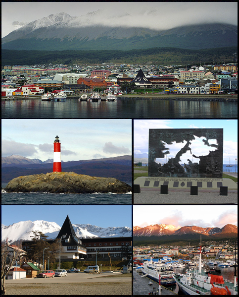
Montage of Ushuaia, Argentina, in the Tierra del Fuego. Source: Wikipedia
Ushuaia is the capital city of Tierra del Fuego Province, in southern Argentina. Widely regarded as the southernmost city in the world, Ushuaia is situated on the southern coast of Isla Grande de Tierra del Fuego, with the Martial Mountains to the north and the Beagle Channel to the south. Tierra del Fuego (in English, “Land of Fire”) is an archipelago on the southern end of South America; the southernmost point on the southernmost island is Cape Horn.
The island chain was first visited by Europeans (on Ferdinand Magellan’s voyage) in 1520, although natives had lived in this region for hundreds of years before then. British missionaries gave the city its name in the mid-1800s, as they were the first to really settle in Ushuaia. The population increased in the 1880s, following rumors of gold, but the rumors proved to be false. In 1896, a federal prison was established in Ushuaia; the president of Argentina had been pushing for the city to become a penal colony since 1873.
Today, Ushuaia has a (2010 estimated) population of 63,280. The primary economic activities include fishing, natural gas and oil extraction, sheep farming, and ecotourism.
A few more facts about Ushuaia:
- Time zone: Argentina Time (UTC-3)
- Average elevation: 16 feet (5 meters)
- Climate zone: Subpolar oceanic
- Average high temperature: 49 °F (9 °C)
- Average low temperature: 35 °F (2 °C)
- Average annual high/low temperature range: 40 to 57 °F (4 to 14 °C) / 29 to 42 °F (-2 to 5 °C)
- Record high temperature: 85 °F (29 °C)
- Record low temperature: -13 °F (-25 °C)
- Average annual precipitation: 21 inches (530 mm)
Weather: At nearly 55 °S, Ushuaia experiences short, cool summers and long, somewhat wet and cold winters. The climate of Tierra del Fuego may be compared to that of the Aleutian Islands. The southern tip of South America frequently gets hit by low-pressure systems, and this week is no different.
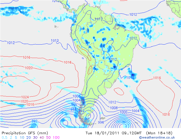
GFS model forecast for surface pressure and precipitation over South America this morning…note the lows (blue concentric circles) on the bottom of the map. Click to enlarge. Source: Weather Online UK
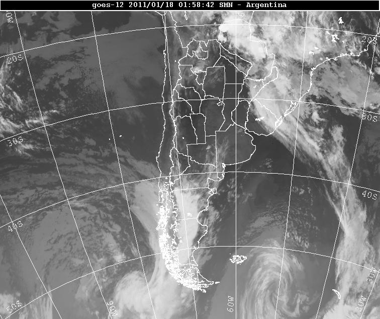
Infrared satellite image of southern South America from last night. Note the two swirls at the bottom of the image; those are the low-pressure systems (moving from west to east). Source: Servicio Meteorológico Nacional
There is a chance of rain every day and night this week for Ushuaia; but then again, the average number of rainy days per year for Ushuaia is 214. It is also pretty windy down there…winds this week may range from about 10 to 30 mph, mostly from the west. Temperatures are pretty typical for this time of year, with forecast highs in the lower 50s and lows in the upper 30s.
For weather maps and information on current and forecast Ushuaia weather, see the Servicio Meteorológico Nacional (Argentinian National Weather Service), Weather Underground, and Weather Online UK.
For more information on Ushuaia, here’s a link to Wikipedia.
Next Tuesday we will take a look at the climate and weather in another part of the globe. As always, if you have any suggestions for future cities, please leave a comment!
Permalink
01.11.11
Posted in Non-US Weather, Weather News at 8:00 am by Rebekah
This week’s post in the global weather and climate series features Antananarivo, Madagascar.
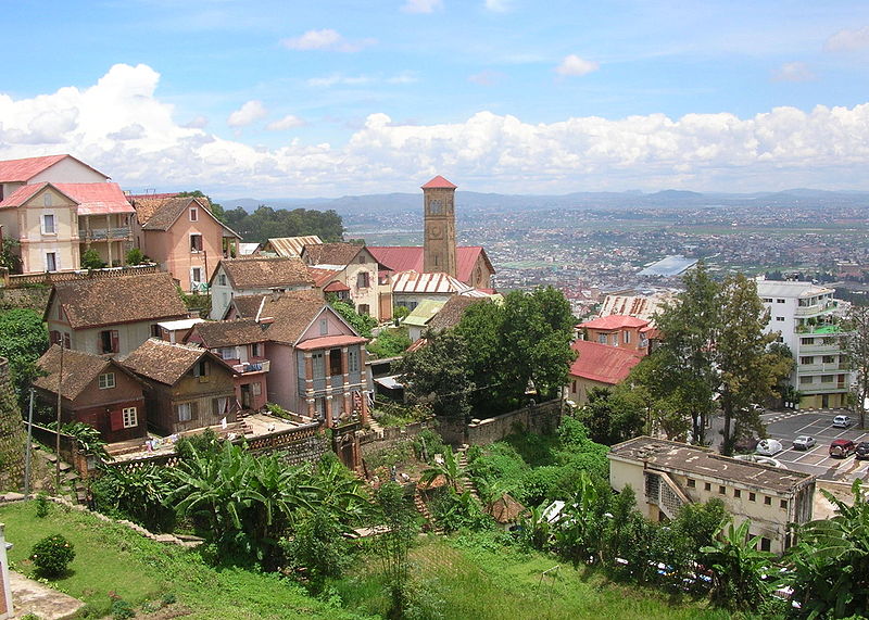
Looking down on Antananarivo, Madagascar. Source: Wikipedia
Situated on a mountain ridge, near the center of the island lengthwise and about 90 miles west of the eastern coast, Antananarivo is the capital of and the largest city in Madagascar. Founded in 1625, by the king of the Merina (an ethnic group from Madagascar), Antananarivo (formerly Tananarive) means “the city of the thousand”, taken from the number of soldiers assigned to guard it. In 1793, the city was made the capital of the Merina kingdom. About one hundred years later, Antananarivo was captured and colonized by the French. Madagascar finally gained independence from the French in 1960.
Today, Antananarivo is the economic and administrative center of Madagascar, with a population (in 2001) of 903,450 (1,403,449 in the metro). Exports include food, cigarettes, and textiles. Antananarivo is home to the University of Madagascar/Antananarivo, an Anglican cathedral and a Roman Catholic cathedral (as well as over 5,000 other church buildings), and Ivato International Airport (with service to Nairobi, Johannesburg, and Paris). Malagasy is the official language of Madagascar, though French is spoken there as well.
A few more facts about Antananarivo (from Wikipedia):
- Time zone: East African Time (UTC+3)
- Average elevation: 4,186 feet (1,276 meters)
- Climate zone: Temperate / subtropical highland
- Average high temperature: 75 °F (24 °C)
- Average low temperature: 57 °F (14 °C)
- Average annual high/low temperature range: 68 to 82 °F (20 to 28 °C) / 51 to 62 °F (10 to 17 °C)
- Record high temperature: 95 °F (35 °C)
- Record low temperature: 34 °F (1 °C)
- Average annual precipitation: 54 inches (1,365 mm)
Weather: At 18.5 °S, Antananarivo lies in the tropics of the Southern Hemisphere, thus the climate is warm and wet; however, the mountains keep the temperature milder than it would be otherwise. The coolest, driest months are from April to October.
Currently, every day this week is forecast to have a high near 82 and a low near 60. Scattered showers and thunderstorms are also forecast every day and night, with only a small amount of rain expected each day.
For weather maps and information on current and forecast Antananarivo weather, see Weather Underground and Weather Online UK.
For more information on Antananarivo, here’s a link to Wikipedia.
Next Tuesday we will take a look at the climate and weather in another part of the globe. As always, if you have any suggestions for future cities, please leave a comment!
Permalink
01.04.11
Posted in Non-US Weather, Weather News at 8:01 am by Rebekah
This week’s post in the global weather and climate series features Rockhampton, Australia. Rockhampton is currently undergoing one of Australia’s worst flood events on record.
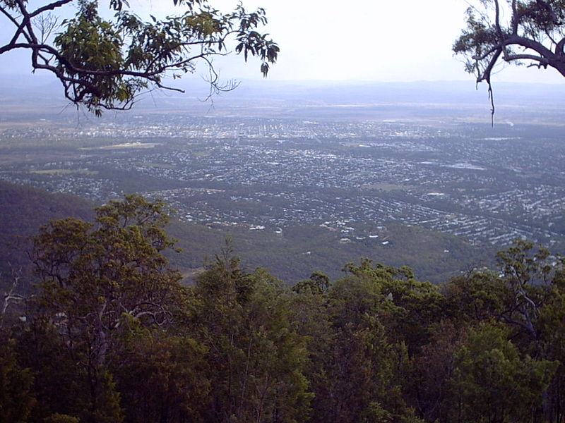
Rockhampton, from Mount Archer. Courtesy of Wikipedia.
Rockhampton is located in a hilly part of northeastern Australia, in the state of Queensland. Situated on the Fitzroy River, about 25 miles from the Coral Sea, Rockhampton lies just north of the Tropic of Capricorn.
Rockhampton was founded in the mid-1800s, as grazing lands and eventually gold attracted European settlers. Cattle continue to serve as a large part of the city’s economy, and Rockhampton promotes itself as the Beef Capital of Australia. The current population of the city is 76,729.

The Rockhampton Zoo features a Cassowary, naturally found only in New Guinea and far northeastern Queensland. A large, flightless bird, the Cassowary is smaller only than the ostrich and emu. Courtesy of Wikipedia.
A few more facts about Rockhampton (from Wikipedia):
- Time zone: Australian Eastern Standard Time (UTC+10)
- Average elevation: 37 feet (11.3 meters)
- Climate zone: Humid subtropical
- Average high temperature: 83 °F (28 °C)
- Average low temperature: 62 °F (17 °C)
- Average annual high/low temperature range: 74 to 90 °F (23 to 32 °C) / 49 to 72 °F (10 to 22 °C)
- Record high temperature: 114 °F (45 °C)
- Record low temperature: 30 °F (-1 °C)
- Average annual precipitation: 31 inches (799 mm)
Weather: Rockhampton is currently inundated, following copious amounts of rainfall during a tropical cyclone and various summer thunderstorms. The airport has been shut down (due to flooding) and only one escape route remains for the city. The water level in the Fitzroy River has reached 30 feet and is expected to go even higher by tomorrow, at which point the city should become completely isolated.
The area of Queensland that has been subject to the floods is greater than the size of Texas and greater than the size of France and Germany combined, with over 200,000 people being affected. Many people have had to leave their homes because the waters are too high. For more on the floods, see Sky News, BBC News, and MSNBC. Latest flood warning for the Fitzroy River.
Rockhampton experiences, on average, some 300 sunny days per year; however, there has been a trough of low-pressure situated over the Queensland coast for quite some time now, providing very rainy conditions. This setup is fairly common during La Niña years.
Unfortunately, as we are in a fairly strong La Niña, it does not look like Queensland will receive much relief from the rain any time soon. It may even take as long as a month before Queensland sees much relief from the rain and floodwaters.
For weather maps and information on current and forecast Rockhampton weather, see the Australian Bureau of Meteorology, Weatherzone, Weather Underground, and Weather Online UK.
For more information on Rockhampton, here’s a link to Wikipedia.
Next Tuesday I plan to take a look at the climate and weather in another part of the globe. As always, if you have any suggestions for future cities, please leave a comment!
Permalink
« Previous Page — « Previous entries « Previous Page · Next Page » Next entries » — Next Page »


