10.12.10
Posted in Non-US Weather, Weather News at 11:53 am by Rebekah
This week’s post in the global weather and climate series features Copiapó, Chile.
-
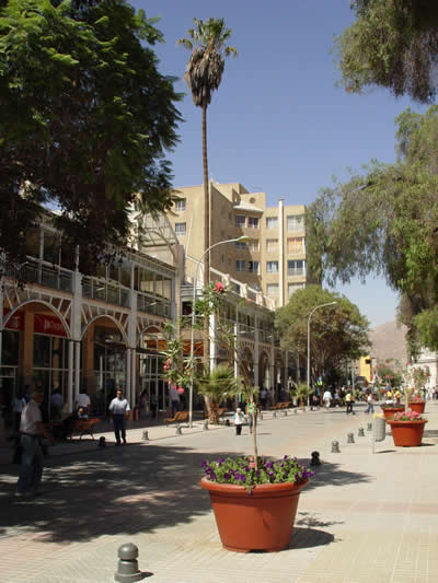
Mall Plaza Real in Copiapó, Chile. From Wikipedia.
As you’ve probably heard, after spending over 2 months in a collapsed mine, 33 miners in northern Chile are about to be lifted up to safety. The nearest town to this mine is Copiapó, so this week I thought I’d take a look at what the climate is like there.
Copiapó, in northern Chile, was founded in 1744 by the Copiapó River, which has since then dried up. The city is primarily a copper mining town (silver is also mined around there), with agriculture (grapes, olives, tomatoes, avocadoes, and citrus fruits) coming second. Because Copiapó is surrounded by the Atacama Desert, it receives very little rain. The Atacama Desert is the driest desert on Earth, even though it lies on the Pacific Coast. Primary reasons the desert is so dry include the Humbolt Current off the coast (cold waters well up off the coast, keeping the air drier) and the Andes Mountains to the west (wind comes from the west and creates a rain shadow on the leeward side of the mountains). Copiapó is home to 129,091 people.
A few more facts about Copiapó (from Wikipedia):
- Time zone: Chile Standard Time (UTC-4) or Chile Summer Time (UTC-3)
- Elevation: 1,283 feet
- Climate zone: Desert / steppe
- Average high temperature: 79 °F (26 °C)
- Average low temperature: 55 °F (13 °C)
- Average annual precipitation: 0.5 inch (12 mm)
Current weather: Copiapó is the Southern Hemisphere, so it is currently spring there with summer coming soon. High temperatures this week are expected to start in the upper 60s, getting to upper 70s by the end of the week. Lows are forecast to be in the mid-40s to lower 50s. Skies are mostly clear although there is a slight chance of a trace of rain for tonight. Fog is common at night.
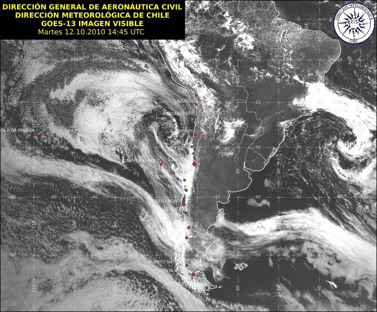
Here is a recent visible satellite image for South America, showing the location of Copiapó (from Meteo Chile, click to enlarge):
For weather maps and information on current and forecast Copiapó and Chile weather, see Meteo Chile (Chile’s meteorological agency website, in Spanish), Weather Online UK (maps, models, and forecasts for around the world), and Weather Underground.
For more information on Copiapó, here’s a link to Wikipedia, and here’s a link to Spanish Wikipedia (even more info, just in Spanish).
Next Tuesday I plan to take a look at the climate and weather in another part of the globe. As always, if you have any comments or suggestions for future cities, please leave a comment!
Permalink
09.21.10
Posted in Non-US Weather, Weather News at 4:06 pm by Rebekah
This week’s post in the global weather and climate series features Sarh, Chad.

Chari River, near Sarh, Chad. From Kejsa Media Network.
This time of year, central African weather is dominated by tropical (aka easterly) waves. Tropical waves are low-level troughs within the tropics, which provide lift for thunderstorms and are a major source for tropical cyclone development.
Sarh, in south central Chad, is currently under a cloud cluster associated with one of these tropical waves. If the tropical wave survives its journey across Africa, it could have a chance at becoming a tropical cyclone in the Atlantic Ocean.
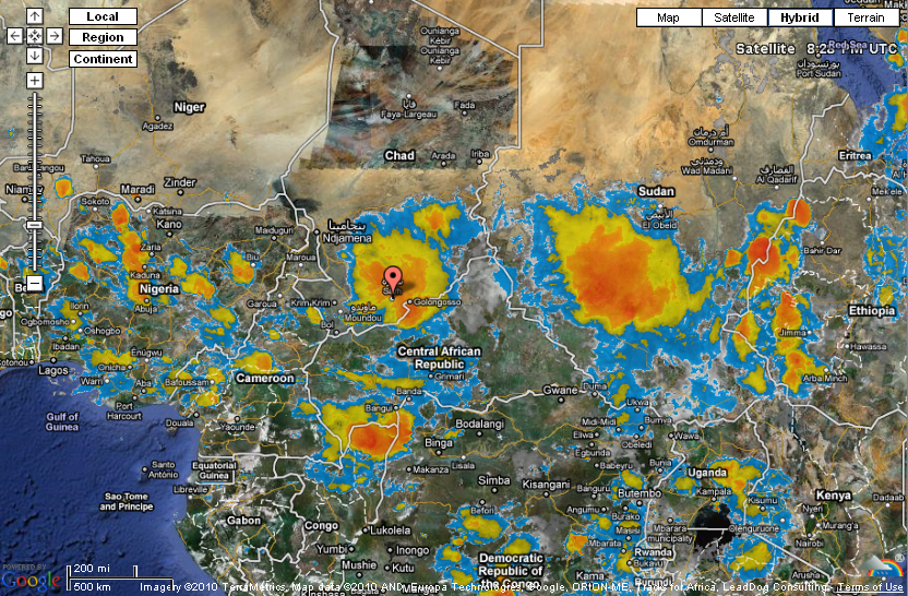
Infrared satellite image over central Africa, showing at least two cloud clusters associated with tropical waves. From Weather Underground. Click to enlarge.
Sarh has a population of 108,061, and is the 3rd largest city in Chad. Located on the Chari River, Sarh is about 30 miles north of the Central African Republic. Sarh, formerly known as Fort Archambault, was founded by the French for returnees from Congo-Ocean Railway labor camps. Today Sarh is a major transport hub and a center for the cotton industry.
A few more facts about Sarh (weather data from World Climate):
- Time zone: West Africa Time (UTC+1)
- Elevation: 1,138 feet
- Climate zone: Tropical savanna
- Average high temperature: 95 °F (35 °C)
- Average low temperature: 71 °F (22 °C)
- Average annual precipitation: 38 inches (969 mm)
Current weather: Sarh is expecting thunderstorms to continue throughout this week and next, as a result of the tropical wave currently over Sarh and the next one coming their way. Highs this week will be in the upper 80s to lower 90s, with lows in the lower 70s and dewpoints in the upper 60s to lower 70s.
For weather maps and information on current and forecast Sarh and Chad weather, see Weather Online UK (maps, models, and forecasts for around the world), and Weather Underground.
For more information on Sarh, here’s a link to Wikipedia.
Next Tuesday I plan to take a look at the climate and weather in another part of the globe. As always, if you have any comments or suggestions for future cities, please leave a comment on this post!
Permalink
09.14.10
Posted in Non-US Weather, Weather News at 3:50 pm by Rebekah
This week’s post in the global weather and climate series features Naples, Italy.

The Bay of Naples, from the Sant’Elmo Castle. Mount Vesuvius is on the left. Courtesy of Wikipedia. Click to enlarge.
Naples (Napoli in Italian) is one of the oldest cities in the world, founded sometime in the 9th century BC. It is needless to say that Naples has a long, rich European history, as the city has seen several civilizations come and go. Naples is situated on the Bay of Naples, on the southwest Italian coast. The city lies in the shadow of Mount Vesuvius, which famously blew up in 79 AD, burying the city of Pompeii for nearly 1600 years.
A few more facts about Naples (from Wikipedia):
- Time zone: Central European Time (UTC+1) or Central European Summer Time (UTC+2)
- Elevation: 0 to 56 feet
- Climate zone: Mediterranean (mild, wet winters, warm/hot, dry summers)
- Average high temperature: 69 °F (20 °C)
- Average low temperature: 51 °F (10 °C)
- Average annual precipitation: 39.6 inches (1,007 mm)
Naples’ average monthly low and high temperatures range from 39 °F to 85 °F.
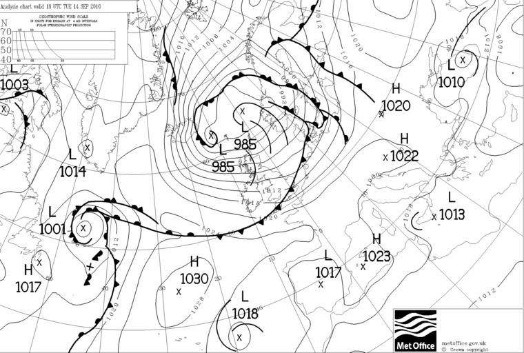
Current weather: Southern Italy is currently under weak low pressure, with no big disturbances nearby (see below, from the UK Met Office). The weather is pretty mild, with highs in the upper 70s this week and lows in the lower 60s. Skies are clear, but there is a slight chance for rain tonight. Low pressure systems are staying primarily in northern Europe, with high pressure systems south of Italy, so the weather is expected to remain pleasant.
Italy occasionally gets severe thunderstorms, especially in the fall. ESTOFEX, the European Storm Forecast Experiment (forecasts for severe weather in Europe), has actually predicted a slight risk of severe storms over southern Italy for today and tonight (see below). This severe weather risk is at 5% for severe weather within 40 km (25 miles) of a point. Severe weather is defined as a tornado, hail of up to 2 cm (0.79 in) in diameter, wind speeds of at least 25 m/s (56 mph), or excessive rainfall of 60 mm (2.4 in) in 3 hours or 90 mm (3.5 in) in 6 hours.
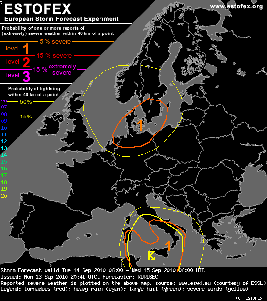
The discussion for southern Italy read (emphasis added):
“Areas from Thyrrenian sea southwards into the southern Mediterranean will be affected by the slowly moving upper low. Moderate instability seems to become available, which should support deep convection. Despite the rather limited shear in place, as the mid-level jet slowly weakens, numerous organized storms will form. Multicells and a couple of rotating storms can be possible. Given their rather slow moving nature, they should bring threat for intense rainfalls as well as some marginal hail in the beginning before they cluster. Train-effect of the storms should locally enhance flash floods. Warm SSTs and steep LL lapse rates could also result in a couple of waterspouts.”
The ESTOFEX website can be found here.
For weather maps and information on current and forecast Neapolitan (yes, that’s of Naples) and Italian weather, see Meteo Italia (Italy’s weather service), Weather Online UK (maps, models, and forecast for around the world), and Weather Underground.
For more information on Naples, here’s a link to Wikipedia.
Next Tuesday I plan to take a look at the climate and weather in another part of the globe. As always, if you have any comments or suggestions for future cities, please leave a comment on this post!
Permalink
09.07.10
Posted in Non-US Weather, Weather News at 6:43 pm by Rebekah
This week’s post in the global weather and climate series features Christchurch, New Zealand.
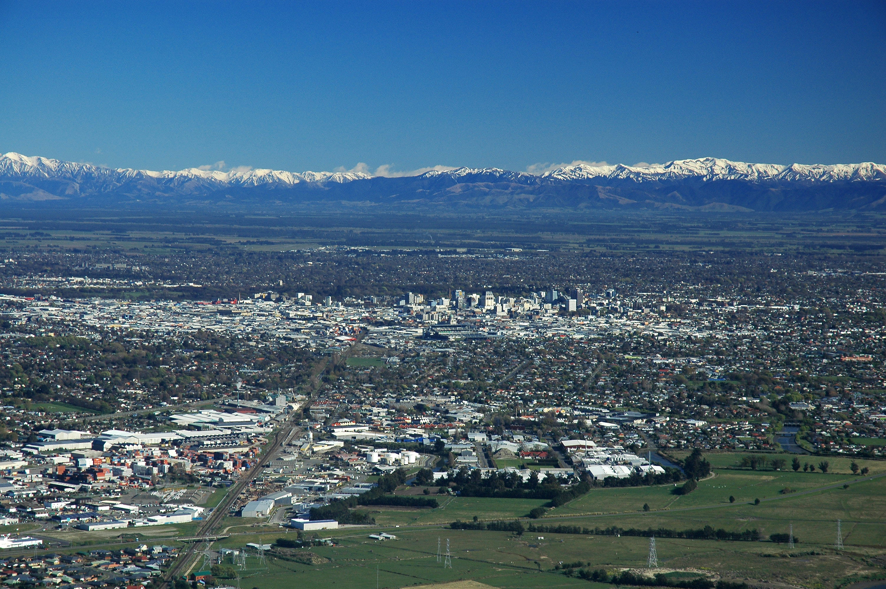
Christchurch City, New Zealand, from the Port Hills. The Southern Alps are in the distance. Courtesy of Wikipedia. Click to enlarge.
Christchurch, in the region of Canterbury, lies about 1/3 of the way down the southeast coast of New Zealand’s South Island (43.5 °S, 172.5 °E). New Zealand is about 1,200 miles southeast of Australia. Bordered by rivers, the Canterbury Plains, the Port Hills (a volcanic mountain range), and the Pacific Ocean, Christchurch, with a population of 386,000, is the second largest city in New Zealand, after Auckland (pop. 1.3 million), on the North Island.
Christchurch has one of the highest quality water supplies in the world. This water comes from aquifers in the Southern Alps, a mountain range that runs northeast to southwest across the South Island. The pristine scenery of New Zealand has served as the backdrop for several movies, including The Lord of the Rings trilogy and The Chronicle of Narnia: the Lion, the Witch, and the Wardrobe.
The United States uses Christchurch International Airport as the takeoff point for the main supply route to McMurdo and Scott Bases in Antarctica.
On Saturday, 4 September 2010, a 7.1 magnitude earthquake struck about 25 miles west of the center of Christchurch, causing about $2 billion NZD in damage (about $1.5 billion USD).
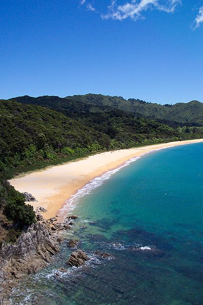
Abel Tasman National Park, on the northern end of the South Island of New Zealand. Courtesy of Wikipedia.
A few more facts about Christchurch (from Wikipedia):
- Time zone: New Zealand Standard Time (UTC+12) or New Zealand Daylight Time (UTC+13)
- Elevation: 0 to 3,018 feet
- Climate zone: Temperate, dry (also oceanic)
- Average high temperature: 63 °F (17 °C)
- Average low temperature: 45 °F (7 °C)
- Record high temperature: 107 °F (42 °C)
- Average annual precipitation: 25.5 inches (648 mm)
- Snowfall: occurs on average once or twice a year in the hills, and once or twice every two years in the plains
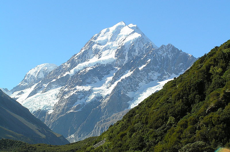
Aoraki/Mount Cook, the highest mountain in New Zealand (12,316 ft). Located in the Southern Alps west of Christchurch. Courtesy of Wikipedia.
Current weather: It is late winter in Christchurch, so temperatures are cooler and the weather is wetter. Christchurch is currently under a high pressure system, which spins counter-clockwise in the Southern Hemisphere. This is bringing the city easterly winds, which are responsible in part for the rainy weather.
Lows this week are in the lower 40s and highs are in the mid- to upper 50s. Christchurch is expecting rain/drizzle all week.
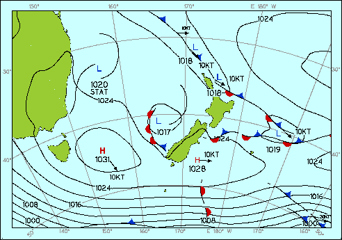
Surface weather analysis for New Zealand today. Courtesy of the Meteorological Service New Zealand Limited.
Occasionally tropical cyclones approach New Zealand, during the Southern Hemisphere summer months (December – April), but by the time they reach that latitude, they are usually weaker and have lost some of their tropical characteristics.
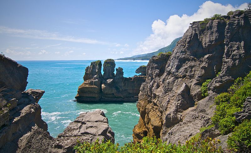
Pancake Rocks, Paparoa National Park, on the west coast of the South Island of New Zealand (northwest of Christchurch). Courtesy of Wikipedia.
For weather maps and information on current and forecast Christchurch and New Zealand weather, see the Meteorological Service of New Zealand Limited (New Zealand’s weather service), Weather Zone (Australia’s leading commercial weather information provider), and Weather Underground.
For more information on Christchurch, here’s a link to Wikipedia. For information on New Zealand, here’s another link to Wikipedia.
Next Tuesday I plan to take a look at the climate and weather in another part of the globe. As always, if you have any comments or suggestions for future cities, please leave a comment on this post!
Permalink
09.01.10
Posted in Non-US Weather, Tropical Weather, Weather News at 5:04 pm by Rebekah
While the U.S. is concerned with what will happen to the East Coast when Category 4 Hurricane Earl passes by (starting tomorrow), as well as what will eventually happen with newly formed Tropical Storm Gaston, another hurricane is just now making landfall at Seoul, South Korea.
Typhoon Kompasu’s eye is coming ashore, with maximum sustained wind speeds estimated at 85 mph (Category 1 on the Saffir-Simpson scale) and a minimum central pressure of 975 mb.
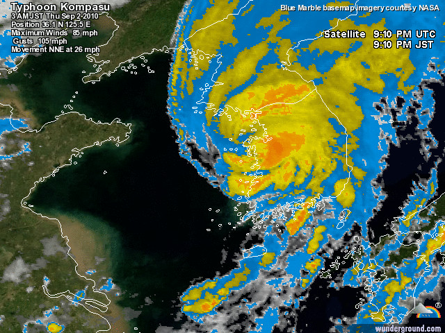
Infrared satellite image of Typhoon Kompasu making landfall, courtesy of Weather Underground.
As of the time I write this post, the pressure is still dropping at Seoul and the wind speeds are still climbing. At the top of the last hour, Seoul recorded rain, winds of 43 mph, gusts to 63 mph, and a pressure of 992 mb. For the latest observations, see the Weather Underground weather history page for Seoul.
Here is a series of radar images from the Korean Meteorological Administration (weather service for South Korea) over the last several hours, showing Kompasu approaching Korea and making landfall.
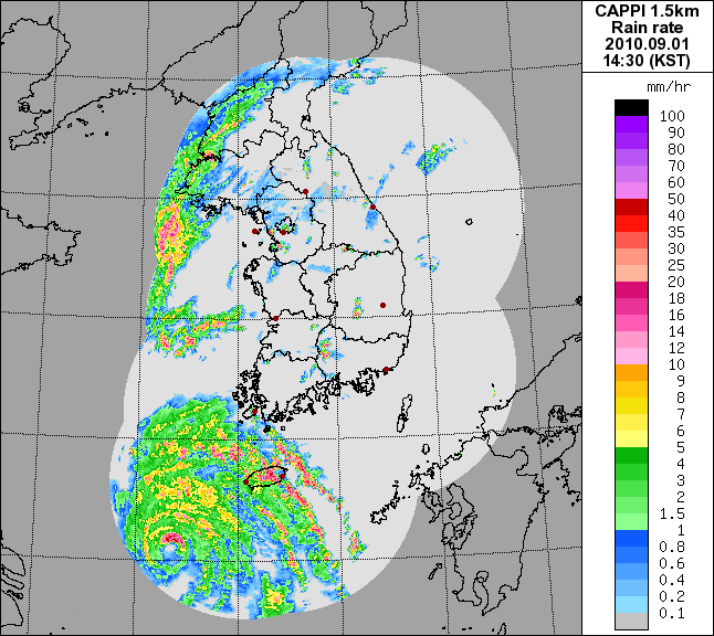
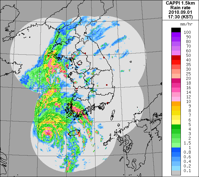
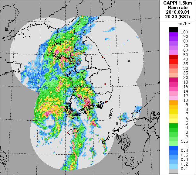
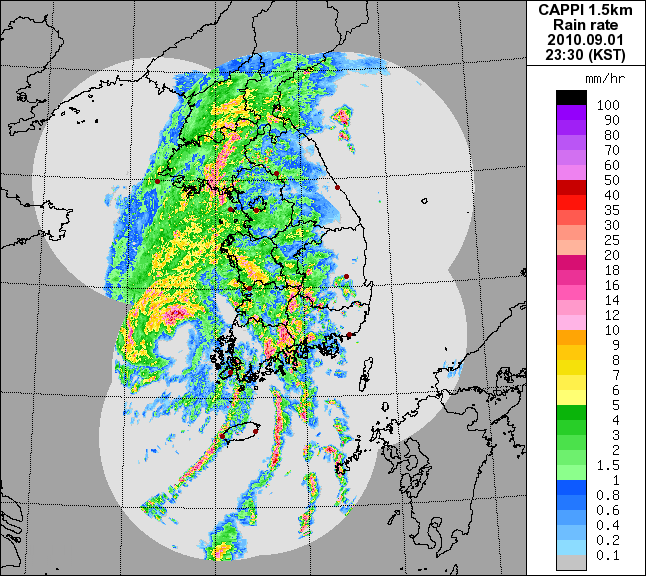
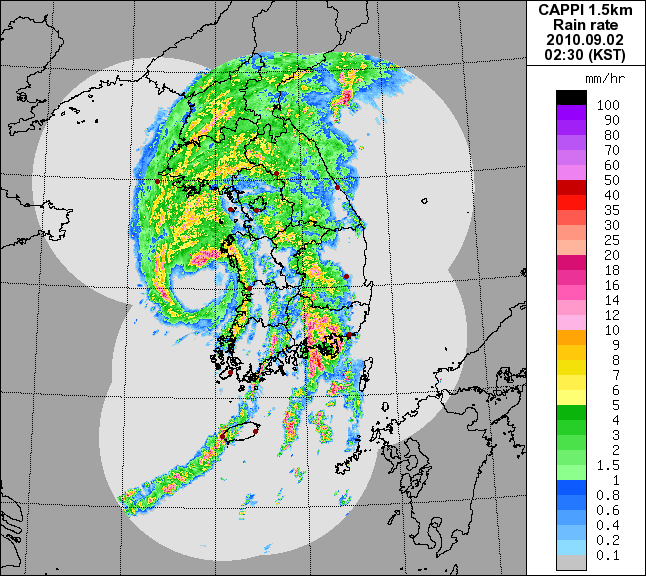
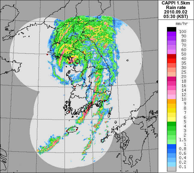
Kompasu will weaken further over land and will be steered out towards Japan.
For the latest Korean weather information, see the Korean Meteorological Administration and Weather Underground.
Permalink
« Previous Page — « Previous entries « Previous Page · Next Page » Next entries » — Next Page »


