03.26.11
Posted in Severe Weather Forecast at 8:00 am by Rebekah
I feel like I’m the only storm chaser who has only chased one day so far this year. I know that’s not true, but a number of chasers have already bagged multiple tornadoes and storms.
To be fair, there really haven’t been any good setups yet in my early season chase region. Before April (or really even May) I don’t like to spend too much gas money on risky setups outside of southern Kansas to northern Texas (including the Panhandle), and I don’t usually chase east of I-35 (at least in Oklahoma).
So the question remains: when will the next good chase setup present itself for the Southern Plains?
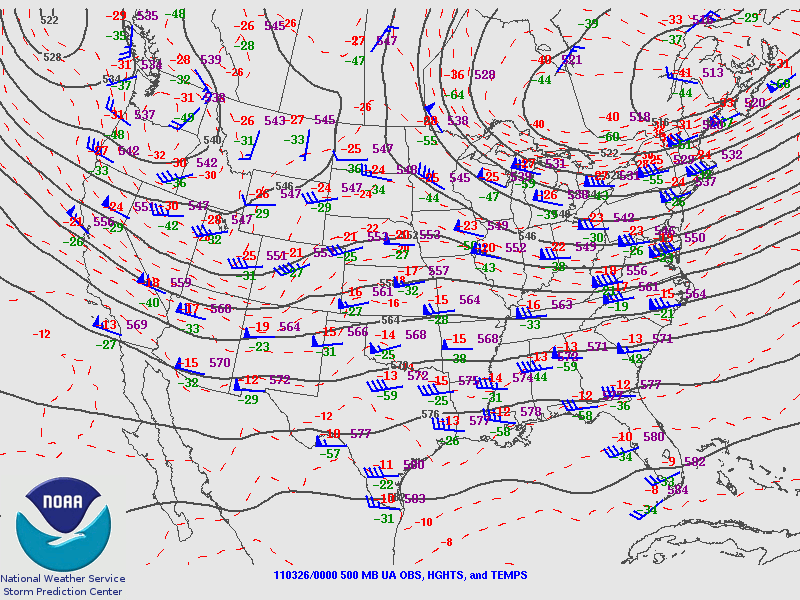
The following 500mb map from 00Z last night (from the Storm Prediction Center) shows rather weak shortwave troughs in the Northwest into the southern Rockies and in eastern Canada, while there’s perhaps a bit of ridging going on in the south central U.S. Not too exciting.

The GFS and NAM models (model observations are based on 00Z runs) do show that the trough in the West will begin to strengthen and dig further south tomorrow. By Monday evening, the models show the trough over Utah with an elongated surface low over northeastern New Mexico and the western Texas Panhandle.
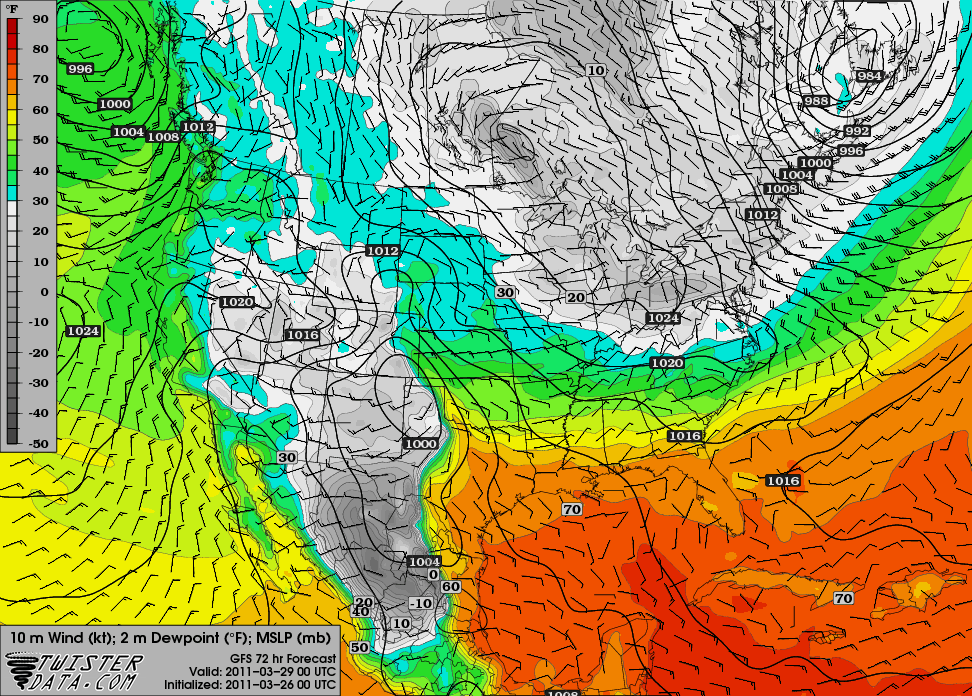
The GFS is a bit more bullish on moisture, as south of the warm front (along the Red River), dewpoints are in the mid- to upper 60s in central into eastern Texas, while the NAM only has these dewpoint values along the Texas Gulf Coast.
The GFS solution for Monday is a bit interesting, but still not enough to tempt me, unless it starts to look better and perhaps sets up a tad further north and west. Also, it looks like the moisture depth will be pretty shallow.

00Z GFS 72-hr forecast for surface pressure and dewpoints, valid 00Z Tuesday (Monday evening), from TwisterData
By Tuesday evening, the GFS shows the trough will have moved on to Missouri. Tuesday may wind up a bigger severe weather day for the lower Mississippi River Valley.
On Wednesday, the GFS indicates another trough may be digging into the southern Rockies, but the model indicates that moisture will be even worse than on Monday, so the chance of storms appears slim at this point.
It also looks like after the Wednesday system, northerly winds will prevent us from getting much moisture return any time soon.
There may be another slim chance or two for severe weather the following week, as some meager moisture may be present in Texas, but it still doesn’t look any good and is too far out to say anyway.
One thing I would bet on, though: I would bet that there will be a good Southern Plains chase day or two (maybe the first outbreak) while I’m in Florida the third week of April. However, I know it won’t bother me as there will always be more tornadoes…but there will only be two more shuttle launches!
Permalink
02.27.11
Posted in Severe Weather Forecast at 8:00 am by Rebekah
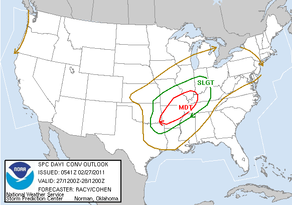
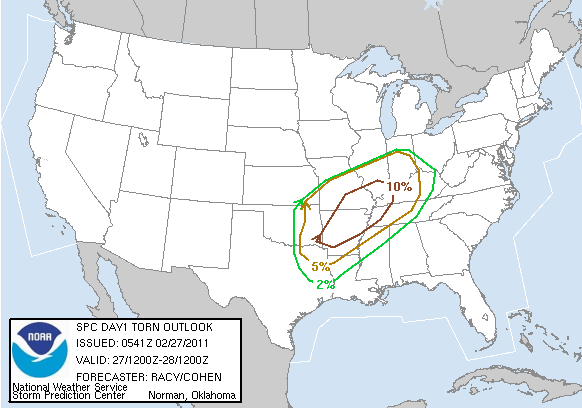
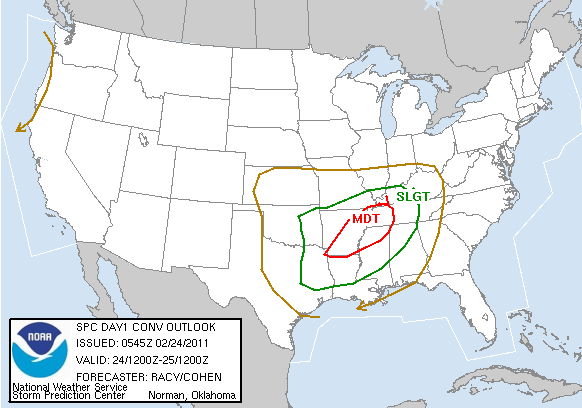
There is another moderate risk for severe storms today, from Arkansas through southeastern Missouri and into the Mississippi River Valley. It does appear that there will be a strong enough cap to prevent very many storms from firing until near or after dark, but there is a chance for an overnight severe weather outbreak.
I again will not be chasing today, and haven’t spent a lot of time looking at this setup…but here’s the 6Z Storm Prediction Center outlook:


Permalink
02.24.11
Posted in Severe Weather Forecast at 8:00 am by Rebekah
The Storm Prediction Center issued the first moderate risk of the year yesterday, valid today and tonight. Today’s moderate risk includes a 15% chance for tornadoes, 30% for 1″ or greater hail, and 45% for severe wind, centered in eastern Arkansas into northwest Mississippi and western Tennessee.

I won’t be chasing this one; I’m planning on waiting for better setups farther west. That being said, this is a fairly potent setup and there may be a similar one in about the same location on Sunday.
I’ll probably post a bit more on this setup and the storms that form later in the day.
Stay safe!
Permalink
02.16.11
Posted in Severe Weather Forecast at 8:00 am by Rebekah
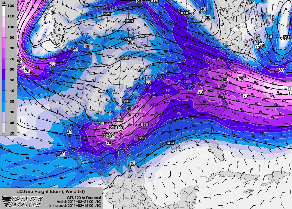
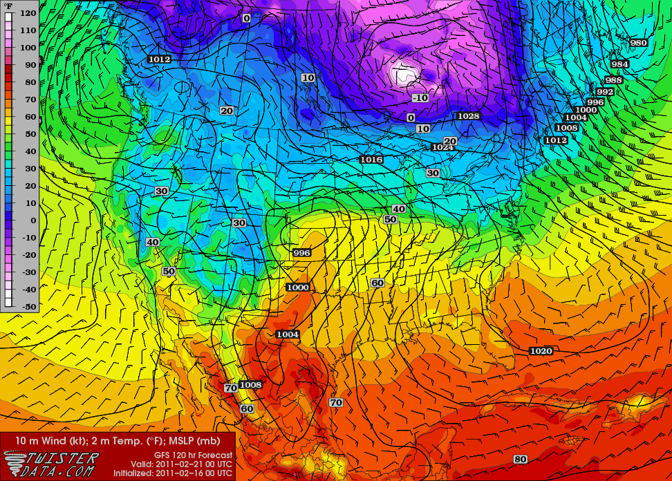
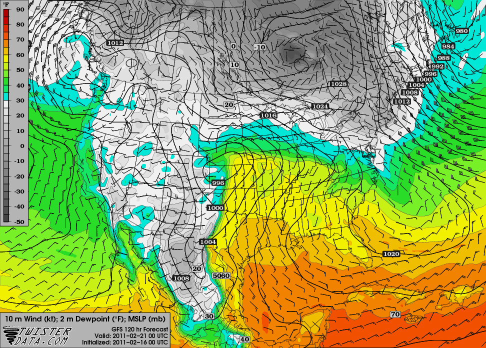
A quick look at last night’s 00Z GFS run for 00Z Monday, or 6 pm Central Time on Sunday (bound to change, but it can be interesting to look at trends as it gets closer):
500 mb shows a nice little shortwave trough centered over New Mexico:

Surface temperatures in the lower 60s in western Kansas and western Oklahoma, with a surface low over western Kansas…surface winds in central Kansas are from the south-southeast:

Surface dewpoints in the lower 50s up through central and eastern Kansas:

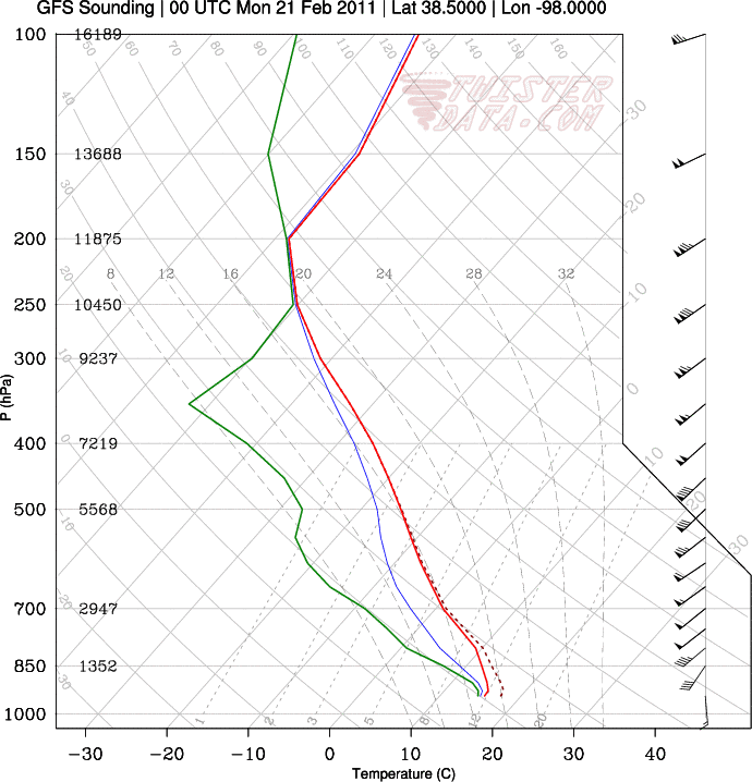
Sounding from Hutchinson, Kansas…would be nice if the high clouds would be gone and the surface could warm up a bit more…but hey, it’s February:

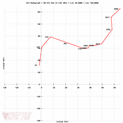
Hodograph for Hutchinson also shows decent wind shear:

Does this mean severe storms are returning to the Plains? No. But even thunderstorms of the non-severe variety would be welcome at this point, and the models are certainly showing some hope of that.
If moisture return is any greater, surface temperatures any higher, and the winds are a little more backed (more out of the southeast), I would be happier and might even consider a jaunt to Kansas, but this is still not a bad setup for February storms. We’ll have to wait and see. There may be another few setups coming soon as well…but a lot of this is still in wishcasting land!
Maps from TwisterData.
Permalink
10.22.10
Posted in Severe Weather Forecast at 11:04 am by Rebekah
The Storm Prediction Center issued a slight risk for severe weather today, with a 5% chance of tornadoes over south central Oklahoma and north central Texas.
A negatively tilted shortwave trough is located through the Texas Panhandle into central Texas, with strong upper-level winds around the base and just downstream of the trough.
An elongated surface low stretches from eastern Colorado into the Texas Panhandle, while a diffuse dryline, expected to tighten this afternoon and move eastward, is situated in the west central Texas Panhandle. There is a pretty significant wind shift along this boundary, with westerly winds in eastern New Mexico, southerly winds in the central Texas Panhandle, and southeasterly winds in the east Texas Panhandle.
Dewpoints in Oklahoma and the Texas Panhandle are in the mid- to upper 50s, but moisture is surging north and they could get into the lower 60s later today.
There is still an MCS in western Oklahoma, but the storm’s outflow boundary in western Oklahoma / southeast of the Texas Panhandle could aid in storm initiation.
There is quite a bit of cloud cover associated with the MCS, which could limit heating and instability, but skies are already clearing in some areas of northern Texas and far western Oklahoma.
CAPE values could reach 1000 or even 1500 this afternoon around Wichita Falls to Shamrock, Texas, and mid-level lapse rates are decent as well.
Vertical wind shear will certainly not be lacking…this morning’s sounding from Norman showed a perfectly curved hodograph. 0 to 6 km shear is at 50 to 60 knots over the Texas Panhandle and northern Texas, and will maintain values close to that into the afternoon / evening. Surface winds are backed over Oklahoma and north Texas, so the chance is decent for supercells to form, if storms initiate and can maintain a solid updraft.
And if supercells do form, there is a decent chance for tornadoes, given low-level wind shear and increasing moisture.
I’m not completely sold on this one yet…I have stick around here ’til 1pm anyway, and I’ll make a decision at that point. As of now, my target would probably be around Wichita Falls, Texas to Altus, Oklahoma.
If I go, it’ll be without streaming or being on Spotter Network, as I don’t want to upgrade my cell plan to tethering again for only one chase. However, I’ll keep you updated!
Permalink
« Previous Page — « Previous entries « Previous Page · Next Page » Next entries » — Next Page »
