06.13.10
Posted in Severe Weather Forecast at 10:24 am by Rebekah
I’m off to the Texas Panhandle this afternoon, as severe weather opportunities have returned to the Southern Plains for a few days.
A deep (though rather weak) trough has dug in to the Four Corners’ region, though the strongest upper-level winds are on the east side of the trough, meaning it is about to start lifting out north as it reaches the Plains. A surface low has formed along the southern New Mexico / Texas border, with an associated stationary front (later becoming warm front) lifting up through central Kansas into Iowa.
A dryline will begin to tighten this afternoon in the central Texas Panhandle, with dewpoints in the upper 60s to lower 70s and surface winds from the south/southeast in the warm sector.
CAPE of between 1500 and 2000 J/kg will be possible over the central to east Texas Panhandle (over 3000 in southeast Kansas and northeast Oklahoma). 0 to 1 km storm-relative helicity values should reach 100 to 200 or greater in the north central Texas Panhandle (0 to 3 km values forecast to reach 300). Surface to 500mb bulk shear vector forecast to be between 40 and 50 knots over the north Texas Panhandle, but barely reaching 30 knots over the south and east Texas Panhandle.
Although the bulk of storms is likely to form over the Kansas/Oklahoma border along the front, the greater chance for strong to severe storms is along the dryline, near the triple point. A line of storms is likely to form from the central Texas Panhandle up into Kansas by the evening, but I expect some of the storms along the southern end of the line will be supercells that will have the potential for large hail and possibly a tornado or two.
Initial Target: Shamrock/Pampa/Clarendon, Texas
Permalink
05.12.10
Posted in Severe Weather Forecast at 11:36 am by Rebekah
I’m in a hurry to get ready, so this will have to be short.
Thermodynamics are fairly similar to the last couple of days, with CAPE values in Oklahoma over 3000 J/kg, ahead of the dryline along the Texas Panhandle/Oklahoma border. Dewpoints are already in the upper 60s in Oklahoma.
Surface low in the Texas Panhandle today with a warm front extending northeastward through central into northeastern Kansas. A cold front extends south of the low back into southern New Mexico, but that will eventually start to catch up with the dryline tonight.
Shortwave trough over the Four Corners region will assist in providing some lift for storms today, although CINH may prove too high in some areas (e.g., GFS shows high CINH over much of Oklahoma, with the exception of a narrow band in west central Oklahoma ahead of the dryline…while the RUC shows not much CINH everywhere but southeast Oklahoma).
Wind shear may be a bit of a problem, with the highest values of helicity in northeastern Oklahoma into southeastern Kansas, but surface winds are not as backed to the southeast as I would like. If the low-level jet kicks in this evening, we may have more rotating storms.
Suffice it to say that this setup leaves much to be desired in the way of supercells, and it looks as if a broken line may form (I hope to catch the southern end of it, at any rate), but there looks to be a ridge setting in next week and who knows when the next best chase day (especially in the Oklahoma area) will be, so I’m going for it.
Initial target (leaving in the next hour): Enid, Oklahoma.
Permalink
05.10.10
Posted in Severe Weather Forecast at 9:22 am by Rebekah

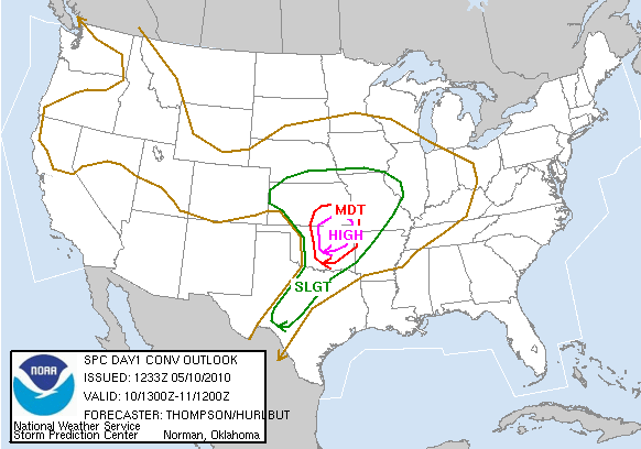
SPC Day 1 Convective Outlook
Hmm…where to start. The first High Risk on the Southern Plains since April 26th of last year, and the third High Risk in less than two weeks. The SPC has the tornado risk at 30% hatched, meaning there’s the potential for EF2 or greater tornadoes within 25 miles of a point.
A shortwave trough is fast approaching and is expected to be over central Kansas / northern Oklahoma by evening. A surface low will move across southern Kansas today, as a warm front lifts through Oklahoma up into central Kansas. A dryline will tighten over west central Oklahoma by late afternoon/evening (NAM dryline keeps pushing back west…something to keep an eye on…), when a narrow band of 70F dewpoints is forecast to stretch north through central up into northeastern Oklahoma.
CAPE of 3000 to 4000 J/kg is expected along the dryline, from northeastern Oklahoma southward all the way to San Antonio. Mid-level lapse rates will be very steep in this region, approaching dry adiabatic.
With south-southeasterly surface winds in central into eastern Oklahoma and southeastern Kansas (the NAM shows better backed southeasterly winds in north central/northeastern Oklahoma and southeastern Kansas, ahead of a dryline a bit farther west of the GFS), and west-southwesterly winds at 500mb, shear profiles will be more than sufficient for rotating storms. The NAM shows 0-1 km storm-relative helicity values of over 100 in most of Oklahoma (ahead of the dryline), with over 400 in northeastern Oklahoma into eastern Kansas and Missouri (0-3 km SRH is over 300 in Oklahoma and over 500 in northeastern Oklahoma into eastern Kansas and Missouri). Soundings and especially hodographs appear to be textbook for classic supercells in much of Oklahoma (from I-35 east) and southeastern Kansas.
Everything appears to be coming together for a major severe weather outbreak from central into northeastern Oklahoma and southeastern Kansas (although severe storms are certainly possible all the way south along the dryline into west central Texas). Without much of a cap (GFS shows a stronger cap, but it shouldn’t be much of a problem–if anything, it could help stronger, more isolated storms to form), it looks as if there will be supercells with large hail and strong tornadoes from central Oklahoma into southeastern Kansas (and possibly southwestern Missouri near/after dark).
A few early showers in northeastern Oklahoma and south central to southeastern Kansas could set up a few outflow boundaries to assist in storm development later in the day.
Storm motion could be a problem as far as chasing goes, today, as the storms will be moving fast (near 40 mph) through an area with some trees and not the best road network.
Nevertheless, I will be out there streaming today (see my tracking page on my web site), somewhere in north central to northeast Oklahoma. VORTEX2 is already up in the area, hoping to finally record some quality data, hopefully in rural areas.
My target area for the last couple of days has been Ponca City, Oklahoma to Arkansas City, Kansas. If the NAM comes closer to verifying on the dryline than the GFS, storms may form farther west in north central Oklahoma / south central Kansas…however, as storm motions will be pretty fast, it would be better to stay ahead of where I think the storms will form, so I don’t have to play catch-up as much.
I think for now, I will target Blackwell, Oklahoma. I’ll discuss with my chase partners, Jeff and Esther, within the next hour, to see what they think, and then we’ll probably head out around 10:30 to 11 AM…
Permalink
04.22.10
Posted in Severe Weather Forecast at 11:02 am by Rebekah
Today there’s a surface low setting up over Colorado, with a warm front that will later extend through central Kansas and a cold front that will move into eastern New Mexico. A dryline will set up in the central Texas Panhandle, with dewpoints ahead of the dryline in the upper 50s and lower 60s. Winds will back south of the warm front and along the dryline, where CAPE is forecast to reach between 1500 and 2000 J/kg. A large trough with a closed low is moving over the southwest, and will provide the lift and upper-air winds to support strong to severe storms. Wind shear will be present, especially near the warm front.
I expect there will be supercells today along the dryline in the Texas Panhandle, with some large hail and possibly a few tornadoes. Another point of concern is the triple point, up near the low…it’s a bit of a tough decision for me, between messier precipitation and possibly better shear up north in Kansas, and isolated supercells (at least until the cold front catches up to the dryline and we get a squall line, hopefully not ’til after dark) and slightly lower shear along the dryline. At this time I’m favoring the dryline, partly because it’s the Panhandle–and I really can’t resist a dryline chase in the Panhandle of Texas! Besides, cloud cover may prove too formidable up near the low.
I may be streaming today on ChaserTV, if I get my camcorder to work with my old laptop (newer one still in the shop). I will probably be on Spotter Network as well.
Target: Childress, Texas, to possibly Clarendon/Silverton
Time of Departure: now!
Permalink
04.01.10
Posted in Severe Weather Forecast, Weather News at 3:08 pm by Rebekah
Here we go!
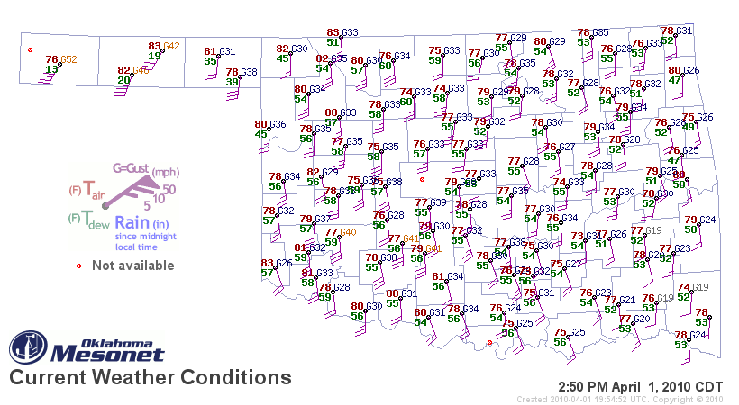
Oklahoma dewpoints are finally in the mid-50s; some dewpoints in western Oklahoma are already up to 60 today, ahead of a dryline. Note the surface map below (click to enlarge), as of 2:50pm, from the Oklahoma Mesonet.
As the legend shows, dewpoint is the number in green. The higher the dewpoint, the more moisture there is in the air. For thunderstorms, especially severe thunderstorms, chasers often look at 60 °F as the magic number.
Note that in the panhandle, dewpoints are in the teens — this is because there is a dryline in the panhandle, or a line where dewpoints are low on one side (with winds usually from the west) and high on the other side (with winds usually from the south or southeast). Temperature is given in the red numbers, while the staffs/barbs at each station indicate wind direction (mostly from the south in this case) and speed (based on number of barbs on the staff).

There is a slight risk of severe thunderstorms today in western Oklahoma, but the cap (temperature inversion that acts as a “lid” to rising air) is so strong it is unlikely that much of anything will break through it.
Tomorrow there is also a risk of severe weather, but primarily east of here. The next time I go chasing may be early next week, as it looks like we will not only have a decent trough, but also finally have the moisture and instability we’ve so desperately needed. The actual day and location is still rather up in the air, but as the models start to resolve the details of the setup, I will begin to have a better idea.
Stay tuned…
Permalink
« Previous Page — « Previous entries « Previous Page · Next Page » Next entries » — Next Page »

