03.10.10
Posted in General News, Severe Weather Forecast, Severe Weather Nowcast at 11:34 pm by Rebekah
I posted my chase log and photos from Monday on my website. See the homepage link on the right side of this page. Or click here.
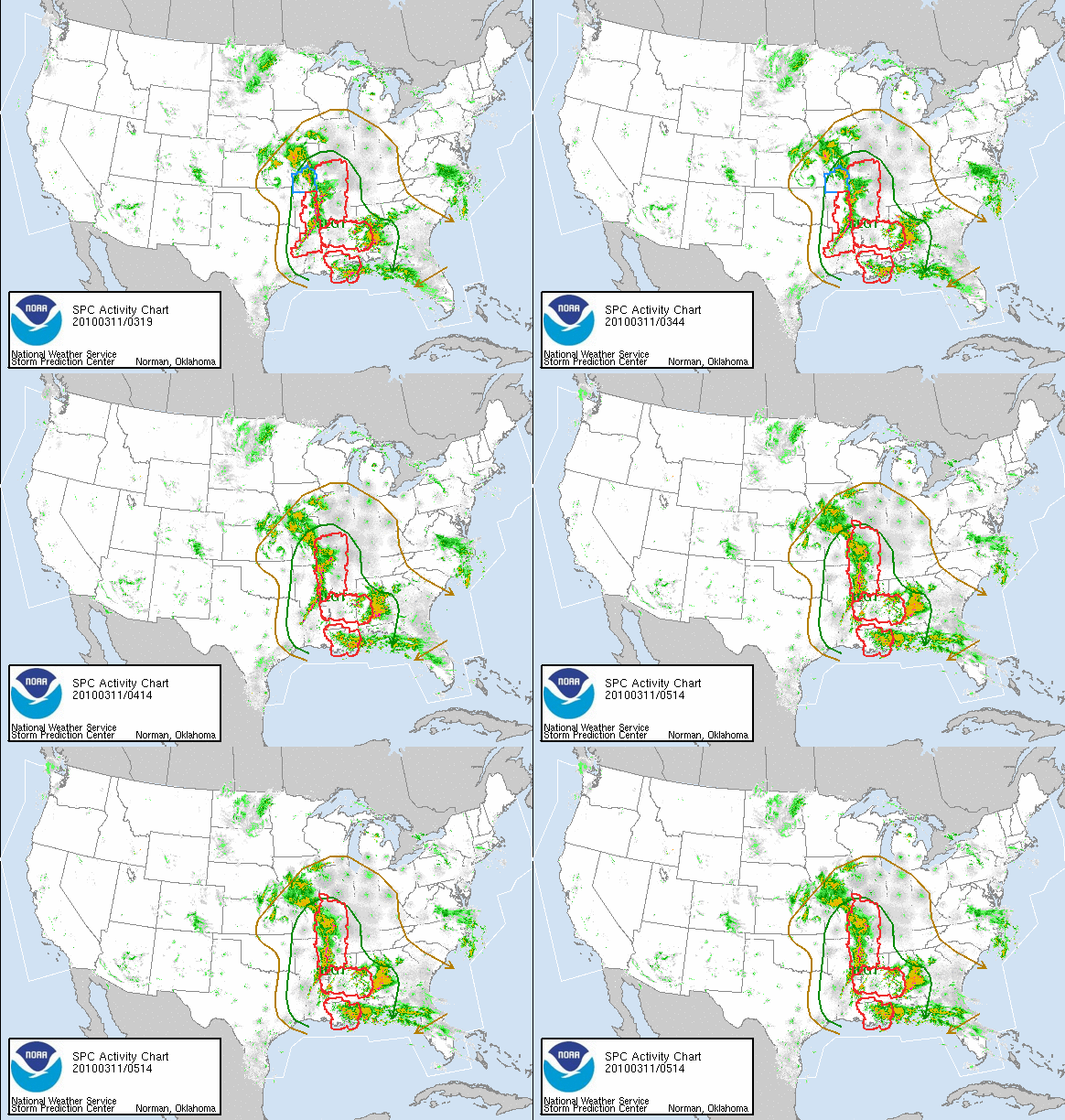
A large upper-level low pressure system, associated fronts and a dryline, moderate instability, and ample wind shear are responsible for severe thunderstorms breaking out today from Kansas to Texas to Alabama. Five tornadoes have been reported so far in Arkansas and Louisiana, with more possible tonight in the Mississippi River Valley region.
A ridge of high pressure is building on the East Coast, and this is going to block the upper-low and keep it from moving out into the Atlantic for the next few days. This means more severe weather could be possible in the eastern US over the next couple of days.

And now, for a special announcement–I have re-discovered Armor All. Sunday afternoon, in anticipation of chasing on Monday, I decided to thoroughly clean out my car. My dashboard was getting woefully dusty, and my trunk was a mess. The other day at Walmart, I saw some Armor All cleaning wipes and remembered that when I was a kid, my Dad wanted me to use Armor All to clean and protect the interior of our car. I don’t think I thought much of the product back then; probably because I didn’t always do the best job of wiping down the car. Or I just didn’t appreciate it. Anyway, I tried using the cleaning wipes on my dashboard on Sunday, and I was blown away. I think my car must have been really dusty and dirty, because I wiped down every inch of the dashboard, console, and door panels, and now–my car glows! Well, at least on the inside. So go out and buy some Armor All–it will make your car look new and happy again. Thanks, Dad. 🙂
Permalink
03.06.10
Posted in Severe Weather Forecast at 1:00 pm by Rebekah
Spring thunderstorms are coming back to the Plains! The first real chase setup looks like it will be on Monday (at least for the Southern Plains; yesterday there was a marginal chase setup in Nebraska/northern Kansas) . It doesn’t look great, but early season storm setups rarely do.
Models are finally showing some consensus on this one; a strong upper-level low/trough is forecast over west Texas by 00Z on the 9th (i.e., 6pm on Monday). Models show a surface low underneath the upper-level low, centered over southeast Colorado/southwest Kansas/west Oklahoma Panhandle/north Texas Panhandle. Surface winds around the cyclone will draw warm, semi-moist air from the Gulf of Mexico up into west Oklahoma. The 60F isotherm is forecast to be in either through southwest or central Oklahoma. It appears that there will be a dryline just ahead of the cold front in the east Texas Panhandle. Surface dewpoints may be in the 50s in southwest and possibly south central Oklahoma, with the 60F isodrosotherm in central Texas. Low CAPE values (a measure of instability–desired for much rising motion) of about 500 to 1000 J/kg may be realized in west Oklahoma and north central Texas. Helicity values (a measure of wind shear) are forecast to be more than decent for rotating storms; between 200 and 350 from 0-1 km in central Oklahoma/north central Texas (as well as a small portion of southwest Oklahoma), and 300 to 650 from 0-3 km in the same region.
Remember how I said the other day there are four primary conditions that severe storm forecasters look for? Monday’s setup has plenty of lift and shear, but moisture and instability are the greatest limiting factors. I am concerned that there may be too much cloud cover over Oklahoma and north Texas for enough heating to occur. I am also concerned that there may not be enough low-level moisture for good storms with low bases. At present, it looks as if there will be so much forcing that storms will break out, but they will quickly form a squall line.
However, I do think there may be some isolated storms perhaps behind the major line, along the dryline, or tail-end charlies (storms at the bottom of a line) that might have a chance of producing something interesting. Even within the line there may be some marginally severe hail.
I am keeping a close eye on this setup and am starting to consider taking a little drive southward on Monday…not so much for the sake of a good chase, but to test out my new equipment and see how coordinated I can be with my new setup on a marginal day. I figure it’s better to test new equipment on a marginal/bad day than on an excellent day and then have everything go wrong. 🙂 For now, I like the area between Wichita Falls, Gainesville, and Graham, Texas, as well as central Texas (though I wouldn’t want to go that far south unless it looked spectacular)…but that could change with the next few model runs…
Permalink
02.20.10
Posted in Severe Weather Forecast at 12:27 pm by Rebekah
Saturday, February 27, 2010…just another cool and stable day, or the first Southern Plains supercell storm chase day of the year? I can dream, right? 🙂
A lot can change in 180 hours, so at this point it’s all wishcasting. Based on the GFS model, a negatively-tilted trough is forecast to dig in to the Oklahoma/Texas Panhandle region by 00Z on the 28th. A closed, upper-level low is over eastern Colorado/western Kansas and positive vorticity advection is occurring is southwest Oklahoma and western Kansas. There is also plenty of warm-air advection in Oklahoma and Kansas (especially in western Oklahoma).
A surface low is forecast in eastern Colorado, and it looks like a cold front may extend south of the low into the Texas Panhandle. The model shows southeast surface winds over northern Texas, Oklahoma, and southern Kansas. Warmest temperatures in the region may be in the mid-50s in western Oklahoma, southwest Kansas, and the eastern Texas Panhandle; temperatures in the Lawton, OK to Wichita Falls, TX area may reach the lower 60s. Dewpoints could reach the lower 50s (highest around Wichita Falls).
CAPE values are forecast to be between 750 and 1000 J/kg in western Oklahoma (not terrific, but could be worse). Both direction and speed wind shear look like they could be sufficient for supercells with even a marginal tornado threat, especially as a low-level jet is forecast in central Oklahoma and central Kansas.
It looks like the biggest problem with regard to severe thunderstorm formation may be the cap…forecast soundings show a high cloud layer over western Oklahoma, which may prevent the surface from receiving enough solar heating to break the cap. IF this can occur (i.e., if the high clouds are able to clear out), and this is a huge if, I think we could be looking at the first decent storm chase opportunity west of I-35 this year, especially from Hobart to Lawton, OK to Wichita Falls, TX.
Stay tuned!
Permalink
01.23.10
Posted in Severe Weather Forecast at 4:09 pm by Rebekah
Here’s my outlook for the chances of severe weather this evening:
There’s a large trough over the western U.S. today, with a surface low in Nebraska. An occluded front stretches south from the low, through western Missouri and western Arkansas. A cold front extends into eastern Texas while a warm front extends through southern Arkansas into Mississippi.
Southeasterly surface winds are bringing moisture from the Gulf of Mexico into the warm sector in Louisiana and southern Arkansas. Temperatures in the warm sector are in the upper 60s and lower 70s with dewpoints in the upper 50s to mid-60s. Instability isn’t the greatest (CAPE of only about 1000 J/kg in the Arklatex region), and soundings this morning showed a cap over much of the region, but upper-level forcing should be great enough to break the cap. A 250mb jet exists over much of Texas, while a 850mb jet of 50 knots is over the Louisiana/Mississippi border into southeast Arkansas. Positive vorticity advection is occurring around northeast Texas into the Arklatex region. There is also a lot of Q-vector convergence in Louisiana, as well as isentropic lift in Louisiana, Arkansas, and Mississippi.
There is already a line of mostly stratiform precipitation along the occluded and cold fronts, with a few convective cells beginning to grow along and ahead of the cold front. Clouds in the area will limit surface heating, which could be a concern for increasing instability; however, a dry slot is entering the Arklatex region, which could be helpful for cooling the air aloft and increasing lapse rates.
Directional and speed shear is sufficient for rotation, and 0 to 1 km and 0 to 3 km SRH values are over 400 m^2/s^2 (local maxima in southeast Arkansas of 550).
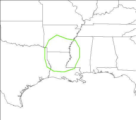
I would expect convection to increase in coverage along the line over the next few hours, with perhaps some strong bow echoes or even a few supercells embedded within the line. I would venture that the greatest threat is hail and high winds, although I would not rule out the possibility of a few isolated tornadoes in southeast Arkansas and northern Louisiana into western Mississippi, especially later tonight provided the low-level jet strengthens even further.
The following map shows where I forecast the greatest severe threat to be this evening/tonight.

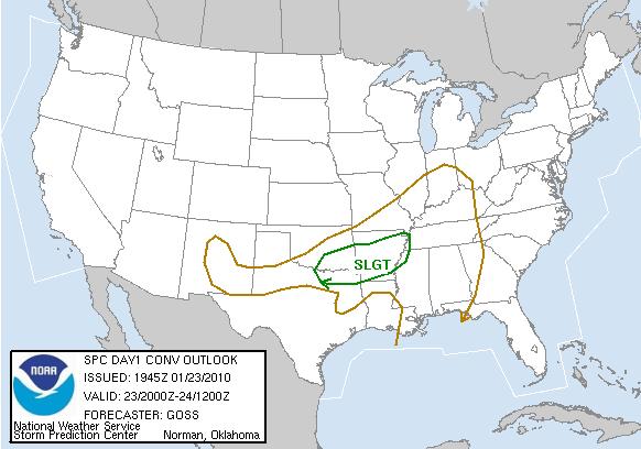
As opposed to the latest SPC outlook:

Permalink
01.19.10
Posted in Severe Weather Forecast, Severe Weather Post-analysis at 8:17 pm by Rebekah
As a follow-up to Sunday’s post, the rain continues to fall in California and now into Arizona. There were a few high wind reports in California today, including 75 mph wind gusts around San Francisco and a 93 mph wind gust near Los Angeles. Furthermore, there were three tornadoes reported around L.A. this afternoon! I’m not certain at this point how they formed. Instability and wind shear were not great in the area; in fact, the environment around San Francisco looked more favorable for tornadoes. I suspect there must have been just enough shear to spin up the brief tornadoes within the storm complex.
As for the potential of severe weather in the southern Plains, dewpoints are already in the lower 60s in eastern Texas and the Dallas/Fort Worth sounding showed a fairly unstable atmosphere this evening, and shear was pretty good, but there was a significant capping inversion. If clouds were not so thick over Oklahoma and Texas, temperatures would have been a little warmer today and there would have been a decent chance for some strong thunderstorms in southeast Oklahoma and east Texas.
Tomorrow’s severe weather setup could be interesting. Based on instability and lift along the cold front, I would think that the greatest chance for severe thunderstorms would be somewhere along I-30 from Dallas to Texarkana. Low-level shear in this area is not bad, but based on the forecast hodographs I would think that the main threat is hail. Shear is forecast to be much greater in Louisiana, but soundings appear to be saturated up to the tropopause. Provided that there are some organized thunderstorms around the mesoscale convective system, I would not be surprised to see a few rain-wrapped tornado reports around the Louisiana/Mississippi border.
Permalink
« Previous Page « Previous Page Next entries »
