03.08.10
Posted in Severe Weather Nowcast at 1:27 pm by Rebekah
About to head out to western OK to go chasing…or more like an equipment testing session with thunderstorms. 😉 There’s already a couple of squall lines, the stronger one being along the dryline. Hoping for some lightning and perhaps small hail. More later…
Permalink
01.23.10
Posted in Severe Weather Nowcast at 4:43 pm by Rebekah
My friend Bryan Smith at the Storm Prediction Center recently issued a Mesoscale Discussion for pretty much the region I just outlined (see below). Convection is increasing in this area and the SPC is monitoring the area, considering issuing a Severe Thunderstorm Watch for high winds:
A MID/UPPER SPEED MAX IS RAPIDLY MOVING EWD ACROSS PARTS OF CNTRL AND ERN TX WITH A PRONOUNCED MID-LEVEL DRY INTRUSION DENOTED ON WV IMAGERY NOSING INTO THE ARKLATEX ATTM. SURFACE RESPONSE TO THIS FEATURE IS NOTED WITH 2 MB/HR PRESSURE FALLS ACROSS SERN AR WHERE AN INTENSIFYING LLJ IS FORECAST. FORECAST SOUNDINGS SHOW A MOIST/MARGINAL THERMODYNAMIC ENVIRONMENT…AND WITH TIME…STEEPENING MID-LEVEL LAPSE RATES. STRENGTH OF SHEAR THROUGH THE PROFILE SUGGESTS THE THREAT FOR DMGG WINDS MAY INCREASE THIS AFTERNOON AND SPREAD TO THE NE THIS EVENING. (SPC–Smith)
Permalink
01.20.10
Posted in Severe Weather Nowcast at 10:13 pm by Rebekah
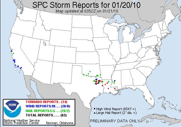
The first severe storm watches of the year were issued today–tornado watches 1 and 2–for northeast Texas, Louisiana, and west central Mississippi. 14 tornadoes have been reported so far–see the map below.

Yesterday I thought there would be more hail reports in northeast Texas, with perhaps an isolated tornado or two, while I thought Louisiana would have more tornadoes because of the greater predicted wind shear.
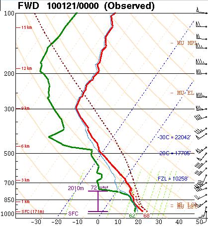
There still is greater shear in Louisiana. However, the Dallas sounding looks great to me in terms of instability and moisture, but although the wind profile doesn’t look terrible, it doesn’t look the best either (see below).

I’m going to keep this short today, as Norman is experiencing some exciting January thunderstorms today as well; we got a little bit of pea-sized hail and lightning earlier this evening, and it looks like more lightning is on its way. The storms in our area are mostly forming just east of the shortwave trough (see below). Back to watching lightning!


Permalink


