10.17.10
Posted in Non-US Weather, Tropical Weather, Weather News at 10:04 am by Rebekah
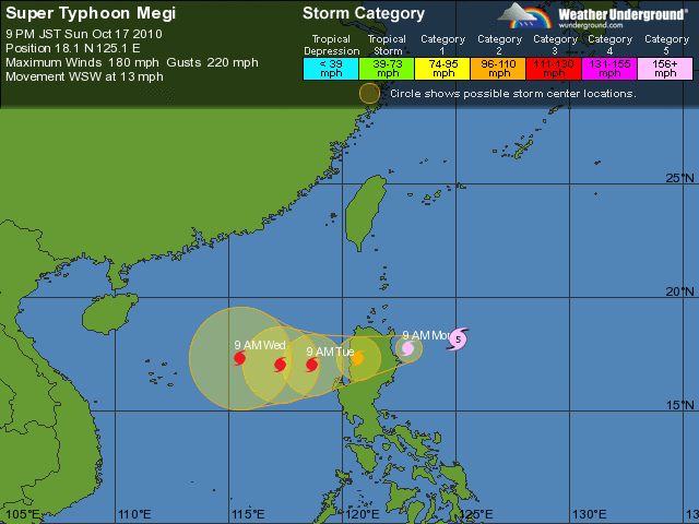
Super Typhoon Megi, a strong tropical cyclone in the western Pacific basin, is forecast to make landfall in the Philippines (on the big island of Luzon) in less than 24 hours.
As you can see from the Weather Underground forecast track below (click to enlarge), if this tropical cyclone were in the Atlantic basin, it would be classified a Category 5, with winds of 180 mph and gusts to 220 mph (pressure is down to 895 mb). Megi is the strongest tropical cyclone in the western Pacific in nearly 20 years.

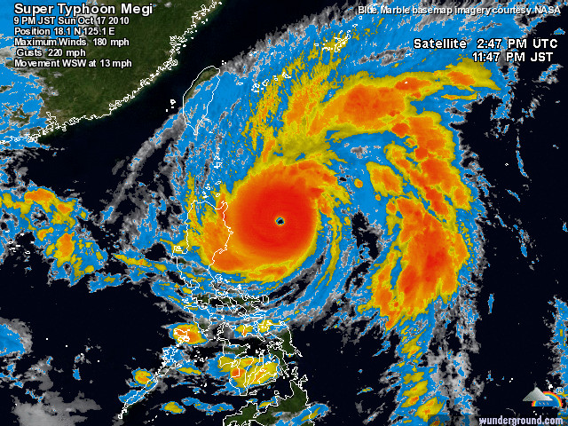
Here’s an infrared satellite image of Megi, again from Weather Underground:

After Megi strikes Luzon as a Category 5, the cyclone will briefly weaken before restrengthening and aiming its sights on southern China.
Permalink
10.15.10
Posted in Tropical Weather, Weather News, Winter Weather at 11:28 am by Rebekah
The nor’easter intensified ahead of schedule, deepening by 16 mb in just 12 hours. A bomb cyclone is an extratropical cyclone which intensifies by 24 mb in 24 hours, so this nor’easter could have come close to that, had the deepening continued.
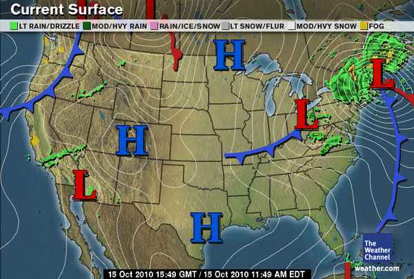
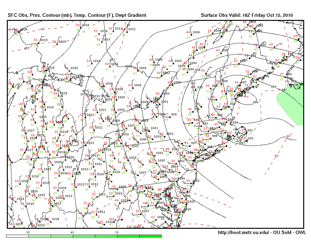
The pressure is now 984 mb, and the first snow (several inches of it) has been reported in the mountains of Vermont and New Hampshire! Winds in the New England area are also pretty strong, as there is a pretty tight pressure gradient with this low.
The Weather Channel map of the cyclone as of 11:49 am EDT:

Oklahoma Weather Lab surface map of the cyclone, as of 12:00 pm EDT (click to enlarge):

In future news, models are picking up on the possibility of a strong hurricane developing in the Caribbean in another week. The GFS model has it crossing over Cuba, but perpendicular to Paula’s track…this one would go south to north across Cuba. Could be something to keep an eye on for those in the Caribbean. The next named storm in the Atlantic would be Richard.
Permalink
09.24.10
Posted in Tropical Weather, Weather News at 3:54 pm by Rebekah

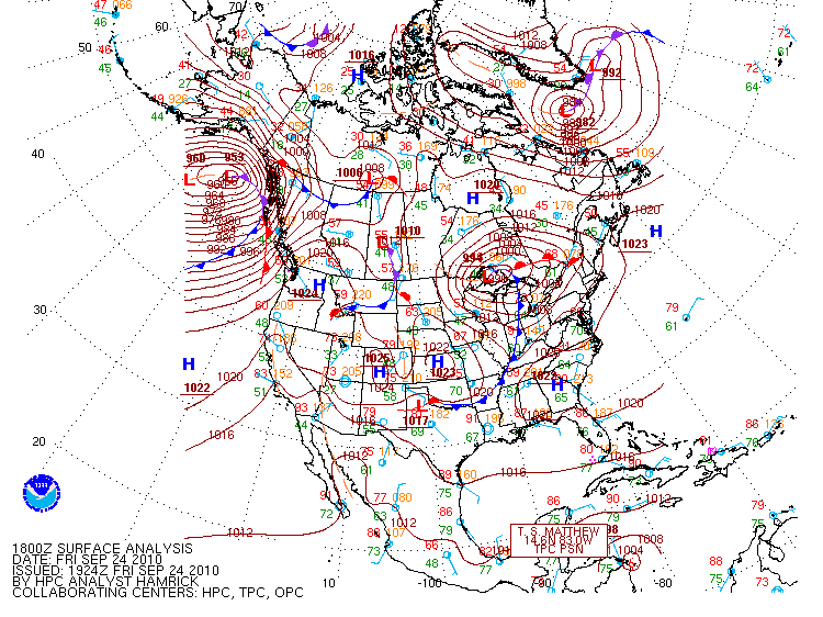
Check out this 18Z (1pm Central Daylight Time) surface analysis from the Hydrometeorological Prediction Center (click to enlarge).
There’s an extratropical cyclone just north of Lake Superior, and a cold front extending southwestward through southern Oklahoma. The low pressure system brought lots of rain to the upper Midwest, and is causing flooding problems in Minnesota and Wisconsin.
NWS rainfall and flooding reports here.
Dramatic news footage of a bridge wiped out in Minnesota.
Cooler air is still to come, behind another cold front that is forecast to make it through Oklahoma Saturday night. This front will bring much more fall-like temperatures to the central and possibly eastern US. The NWS forecast low for Norman on Sunday night is just 51 °F!
Note also that Tropical Storm Matthew is on the map; it’s just now making landfall in Nicaragua. Models do show that another tropical system could form in the Caribbean or Gulf of Mexico within a week. This tropical cyclone could have a chance at making landfall somewhere along the Gulf Coast by the end of next week, although it’s too far out to say if this will actually happen.
Permalink
09.08.10
Posted in Tropical Weather, Weather News at 11:35 am by Rebekah
The rain from Tropical Depression Hermine made it up to Oklahoma this morning. Yesterday, Hermine began to cause some major flooding problems in Texas, and the rain is still coming down in some parts of Texas.
At the moment, Norman is experiencing a lull, as we’re in between a couple of the rain bands. However, we’re expected to get much more rain by tomorrow morning.
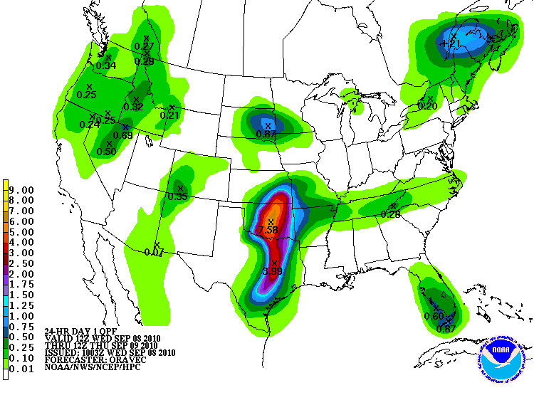
Here’s a look at the Hydrometeorological Prediction Center’s (HPC) rainfall forecast.

Yes, that’s right, 7.58 inches of rain forecast for central Oklahoma from this morning through tomorrow morning! According to the Oklahoma Mesonet, only 0.23 inches of rain has fallen so far in Norman (since midnight). Southern Oklahoma has already received almost 3 inches of rain.
But that’s not all Hermine may bring…the Storm Prediction Center (SPC) has a 5% risk out today for tornadoes from central Oklahoma down into north central Texas. Shear profiles are very favorable for supercells and tornadoes, thanks to Hermine, so the biggest problem will be instability. The SPC believes the greatest threat for supercells and tornadoes is in northern Texas, as that’s where the greater instability is likely to be. Tropical tornadoes tend to be difficult to see (wrapped up in all the rain) and predict (not coming from a traditional Plains supercell). However, these tornadoes are often quite weak (EF2 or less).
I’ve never chased a tropical system or tropical tornadoes before, but I am considering going out this afternoon to give it a try. I’ll give another look at some weather maps and decide this shortly.
In other news, Tropical Storm Igor (9th named storm so far) formed in the far eastern Atlantic this morning. It appears that Igor will become a hurricane in a few days, and possibly a major hurricane. However, Igor will likely recurve before it gets close to land. Models show that Tropical Storm Julia may also form in the next few days.
The 9th Atlantic tropical storm typically forms around October 4th, so we are already a month ahead of schedule, in what the NHC and Colorado State predicted would be an above average year for Atlantic tropical activity…
Permalink
09.06.10
Posted in Tropical Weather, Weather News at 3:51 pm by Rebekah
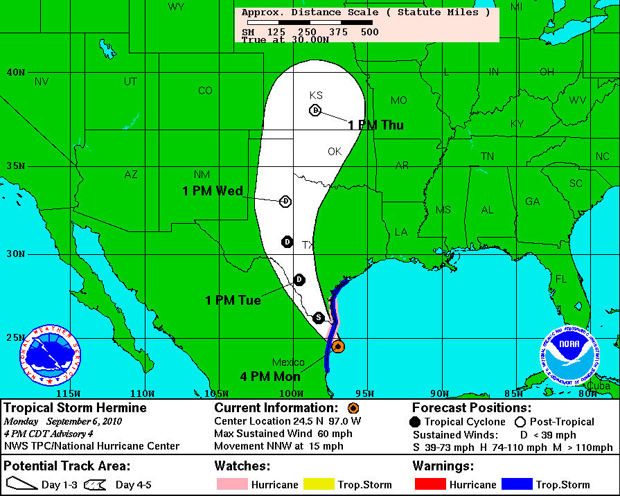
The 8th named storm of the Atlantic hurricane season formed early this morning, Tropical Storm Hermine. Hermine will make landfall near Brownsville, Texas late tonight.
Hermine will then degenerate into a depression and travel up through Oklahoma. This will just mean more rain and thunderstorms on the way soon for Texas and Oklahoma.

Permalink
« Previous Page — « Previous entries « Previous Page · Next Page » Next entries » — Next Page »
