08.26.10
Posted in Tropical Weather, Weather News at 4:30 pm by Rebekah

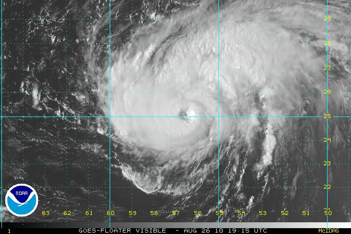
Category 2 Hurricane Danielle, from the NHC.
Yesterday we took a brief look at some of the factors behind tropical cyclone development. Those same factors come into play for tropical cyclone strengthening, particularly the warm water and lack of wind shear.
But once it’s formed, how does a tropical storm or hurricane move?
When tropical cyclones are small and still near the equator, they are at first steered by low-level easterly winds. Once tropical cyclones become stronger and move farther north (or south, if in the southern hemisphere), they are steered by upper-level troughs and ridges.
For example, all else being equal, if there is a trough over the eastern United States, an approaching hurricane will get steered back out to sea by southwesterly upper-level winds on the eastern side of the trough (the hurricane would also “want” to get closer to the falling pressure on the downwind side of the trough).
If there is a ridge over the eastern U.S., all else being equal, the hurricane may want to go south of the ridge and continue towards the coast. Also, if there is a high pressure system downwind of the ridge, the easterly winds on the southern side of the high would also push the storm westward.
Currently, a ridge is moving into the central and eastern U.S….but Danielle and Earl are forecast to stay out at sea. As a trough exits the U.S., Danielle will be pushed up towards the northeast. Also, in this case, the storms formed so far east they began to get pulled clockwise around the semi-permanent high pressure system over the eastern Atlantic (known as the Azores or Bermuda High).
At present, Danielle is a strong Category 2 hurricane with sustained winds of 110 mph and Earl is a strengthening tropical storm. Both cyclones are in areas of warm water and low vertical wind shear, so should continue to strengthen. Danielle should finally become a Category 3 hurricane by tomorrow night, while Earl is also forecast to become a Category 3 hurricane by Tuesday afternoon, at which point the storm may have some effect on the Leeward Islands before recurving back north and east.
In the eastern Pacific, Frank is a Category 1 hurricane with winds of 90 mph, but is forecast to weaken to a tropical depression by Monday, as the cyclone encounters colder waters off the coast of Mexico.
Models are showing that the next Atlantic tropical cyclone may form within a few days. The next name on the list is Fiona, replacing Frances, which was retired following the 2004 hurricane season.
Permalink
08.25.10
Posted in Tropical Weather, Weather News at 7:41 pm by Rebekah

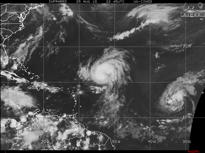
Infrared satellite image of Hurricane Danielle and Tropical Storm Earl. Courtesy of CIMSS. Click to enlarge.
Tropical cyclones are large low pressure systems that form in the tropics and obtain their energy from warm ocean waters, as opposed to extratropical cyclones which form over the mid-latitudes and obtain their energy from cold and warm fronts.
To form, tropical cyclones require:
- warm water (at least 80 °F / 27 °C)
- moist air
- instability
- lift
- a lack of wind shear
- some distance from the equator
Tropical cyclones begin with some sort of disturbance near the surface, usually in the form of a tropical/easterly wave, an old frontal boundary, the inter-tropical convergence zone (ITCZ), or the remnants of a previous tropical cyclone.
A tropical (or easterly) wave is a small, low-level, trough of low pressure located in the tropics. Convergence takes place upstream of a trough, while divergence takes place downstream of a trough. Since the trough is in the lower levels of the atmosphere, that upstream convergence occurs near the surface and is where rising air and clouds can be found. Tropical waves are the most common disturbance from which tropical cyclones form.
The ITCZ is a band of converging and rising air near the equator, as a result of northeast winds north of the equator meeting southeast winds south of the equator.
A tropical disturbance must be at least 5 or 10° away from the equator before cyclogenesis can occur. Supercell thunderstorms and tornadoes get their rotation from strong wind shear, while tropical cyclones get their rotation from the Coriolis force. The Coriolis force is an apparent force that is caused by the rotation of the earth, and acts to deflect objects to the right in the northern hemisphere and to the left in the southern hemisphere. You might have heard of this force with relation to the direction water drains down a bathtub. However, this force only takes effect on much larger scales, such as on the scale of a tropical cyclone. The Coriolis force is near zero at the equator and increases poleward, so tropical cyclones cannot form too close to the equator or they will not be able to rotate.

Get Fuzzy comic (click to enlarge).
Wind shear is a change of wind speed and/or direction over some distance. Vertical wind shear is a change of wind speed and/or direction (usually we talk about both) over height. As I mentioned above, tropical cyclones do not require wind shear to rotate, unlike tornadoes. In fact, if there is too much wind shear, it will rip a tropical cyclone apart and prevent it from further rotation and organization. A tropical disturbance must remain relatively undisturbed (pardon the pun) for some time before it can develop into a tropical depression (and eventually a tropical storm or hurricane). Weak winds throughout the atmosphere are the best for tropical cyclones.
Once a disturbance is in place over warm, moist waters, in an area lacking wind shear and at least 5 or 10° away from the equator, tropical cyclogenesis may occur.
———————————————-
Currently, Danielle is a Category 1 hurricane in the central Atlantic, starting to move northwestward towards Bermuda. Danielle may become a Category 2 hurricane again by Friday afternoon.
Earl is now the 5th named storm of the Atlantic hurricane season, forming this afternoon in the east Atlantic. Earl will move westward for a while, staying south of Danielle’s track and possibly becoming a hurricane by Friday afternoon.
Frank is a Category 1 hurricane just west of Mexico, but is expected to weaken to a tropical storm by Saturday morning, when he will start recurving back towards Baja California (Frank should only be a minor nuisance by then if he hits the coast).
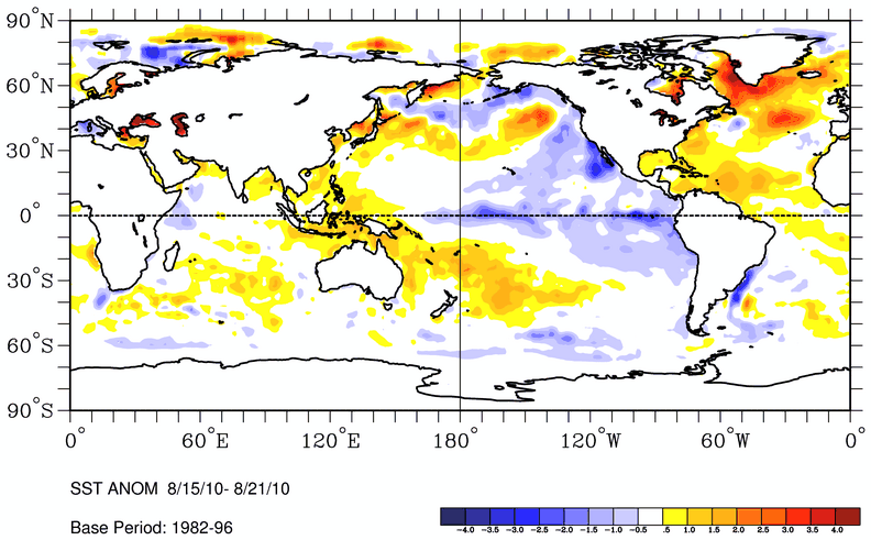
Sea-surface temperatures are above normal in the neighborhoods of Danielle and Earl, where wind shear is also fairly weak, assisting in the cyclones’ strengthening. Both cyclones have been ingesting some dry air over the ocean, though, which can cause a cyclone to weaken (e.g., Danielle’s sudden weakening to a tropical storm). Frank, although in an area of fairly weak shear, will soon be moving into an area of below normal sea-surface temperatures, forcing him to weaken.

Sea-surface temperature anomalies around the world. Courtesy of NOAA ESRL. Click to enlarge.
———————————————-
Tomorrow we’ll talk about some of what causes tropical cyclones to move.
Permalink
08.23.10
Posted in Tropical Weather, Weather News at 6:14 pm by Rebekah

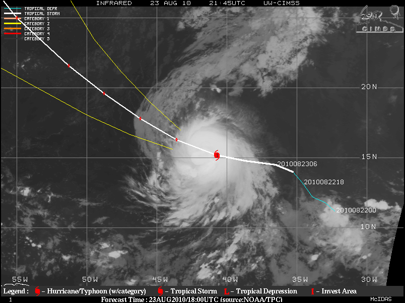
Danielle was upgraded to hurricane status this evening, with peak sustained winds of 75 mph (satellite image from CIMSS, taken at 2145 UTC, or 5:45 pm EDT).
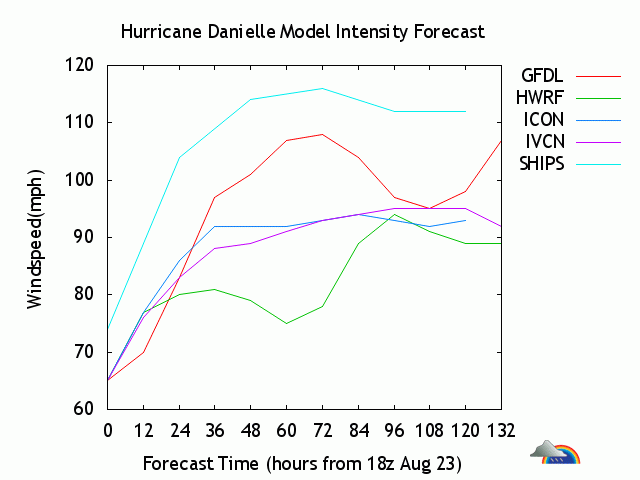
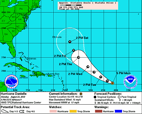
The National Hurricane Center is forecasting that Danielle will reach Category 3 status (111 to 130 mph), peaking around 115 mph, on Wednesday evening.
Here’s a model intensity forecast again from Weather Undergound:

Danielle remains no threat to land; she should start recurving back north and eventually east by the time she gets east of Bermuda (NHC forecast track below).

Meanwhile, back where Danielle first formed, just south of the Cape Verde Islands, another disturbance is starting to organize. This area of low pressure is also in a favorable area for development, and the NHC believes there is a 40% chance of this system becoming a tropical cyclone within the next 48 hours.
Models show that this disturbance could become a tropical storm in the next few days, if it can hold together that long.
The next name on the Atlantic storms list is Earl.
In the eastern Pacific, Tropical Storm Frank is struggling with wind shear just southwest of Mexico, but is expected to become a weak hurricane after a couple days, once he gets into an area of weaker shear. Frank is not a threat to Mexico, but is forecast to move parallel up the coast towards the northwest.
Permalink
08.22.10
Posted in Tropical Weather, Weather News at 3:59 pm by Rebekah
Tropical Depression 6 has just been upgraded to Tropical Storm Danielle.
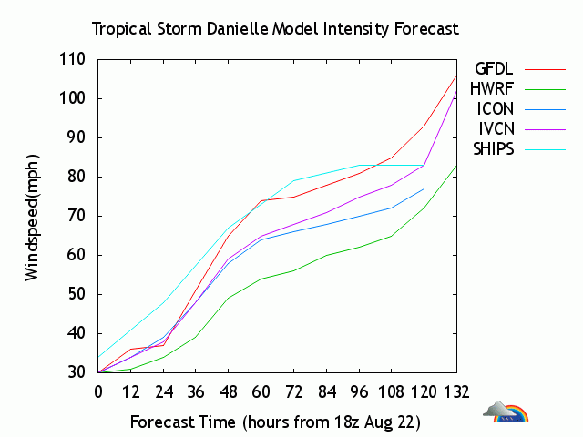
Some vertical shear and dry air will prevent Danielle from strengthening as fast as was previously expected, but it is still expected to become a hurricane by Wednesday afternoon.
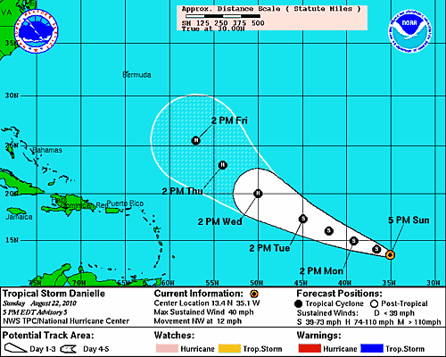
Danielle is moving towards the northwest at present, but is forecast to turn to the west-northwest as it will be steered by a subtropical ridge to its north.

Model intensity forecast, from Weather Underground:

Permalink
08.21.10
Posted in Tropical Weather, Weather News at 4:02 pm by Rebekah

Last night I posted on a tropical disturbance off the Cape Verde Islands that had the potential to become a hurricane within a few days.
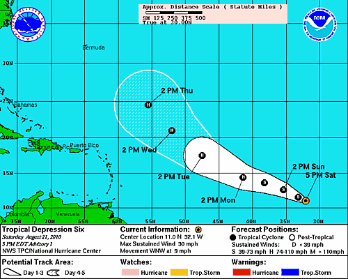
Within the last hour, this system has become organized enough for the National Hurricane Center to upgrade it to Tropical Depression 6 (TD6). The above map shows the NHC forecast track. They have it becoming Tropical Storm Danielle sometime tonight, and a hurricane by Monday afternoon.
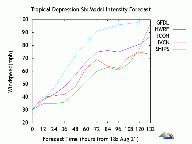
The NHC discussion on TD6 mentions “the NHC forecast is close to the SHIPS/LGEM models…showing a large powerful hurricane over the central Atlantic Ocean in a few days.”
Here’s a model intensity forecast for TD6 from Weather Underground, showing the results of 4 different models. Keep in mind that forecast intensity is not always very good very far out.

Category 1 hurricanes have winds of 74 to 95 mph and Category 2 have winds of 96 to 110 mph.
Stay tuned.
Permalink
« Previous Page — « Previous entries « Previous Page · Next Page » Next entries » — Next Page »
