02.28.11
Posted in Weather Education at 4:00 pm by Rebekah
Meteorologists use two main methods to forecast the weather: analysis of weather data and analysis of weather models. In order to know the state of the atmosphere as accurately as possible, and in order to have the best data to feed into the weather models, we must first take good weather measurements.
A discussion of weather measurements can be broken up into three categories: surface observations, upper-air observations, and remote sensing (e.g., radar and satellite). Today we will touch on surface observations.
Surface Observations
Most surface observations are taken hourly around the world, and include measurements of temperature, dewpoint, pressure, wind speed and direction, cloud cover, precipitation, and current weather (e.g., thunderstorms or fog).
Temperature
Temperature is measured with a thermometer, though not all thermometers today have to be mercury-filled. Temperature can also be measured with an electrical resistor called a thermistor (this is what may be used in your thermostat to help regulate your heater or air conditioner).
Temperature units are given in Fahrenheit (°F), Celsius (°C), or Kelvin (K).
Dewpoint
Dewpoint temperature can not be measured directly, but is calculated from measurements of either the wet-bulb temperature or the relative humidity. Instruments include psychrometers and hygrometers. A psychrometer has two thermometers, one of which has the tip covered by a wet piece of cloth. As the moisture on the cloth evaporates, the temperature on the “wet-bulb” thermometer drops (remember evaporation takes heat, leaving the environment cooler). The drier the air, the more the water evaporates, and the lower the wet-bulb (and dewpoint) temperature.
There are many different types of hygrometers, including electrical ones and ones made of hair. You know how your hair can get frizzy or limp depending on the air’s humidity? Hair hygrometers take advantage of this property, and make humidity measurements based on it.
Dewpoint units are also given in Fahrenheit (°F), Celsius (°C), or Kelvin (K).
Pressure
Pressure was traditionally measured in a mercury barometer. An empty glass tube, closed on the top, would be placed in an open container of mercury, forming a vacuum inside the tube. The higher the pressure, the more the air would push down on the mercury, forcing some of it up the tube.
Today, pressure units are still often given in inches of mercury (in. Hg), though we typically use other types of barometers. Meteorologists report pressure in units of millibars (mb) or hectoPascals (hPa).
Wind
Wind speed is measured with an anemometer. A cup anemometer has three small cups on a horizontal plane, and the faster the wind, the faster the cups spin around. A newer way of measuring both wind speed and direction is with a sonic anemometer. Sonic anemometers just look like a few sticks sticking up, and use sound waves to detect the direction and speed of the wind.
Wind speed units are commonly given in miles per hour (mph), nautical miles per hour (knots), kilometers per hour (km/h), or meters per second (m/s).
Clouds
The amount of cloud cover and the height of the clouds can be measured with a ceilometer. A ceilometer sends up a laser beam which reflects off of clouds. Another way to assess the clouds is to just look out the window. 🙂
Precipitation
Rainfall can be measured with different types of rain gauges. One of my favorite types is the tipping bucket rain gauge, which consists of two small buckets on a seesaw device. When one of the buckets is full, it tips over and empties itself while the other bucket fills up.
Measuring snowfall can be a bit trickier; sometimes snowfall measurements are recorded by someone with a ruler, but there are automated ways of measuring the snow. It’s also important to measure the liquid water equivalent of snow, which is the amount of liquid water if the snow is melted. Even a heavy snow can result in a low liquid water equivalent. A standard snow to water ratio is 10:1 (i.e., 10 inches of snow to 1 inch of water), though a dry snow could be 20:1 or even 40:1 and a very wet snow could be 5:1.
————————————————–
Next Monday we will talk about upper-air observations, including weather balloons.
Permalink
02.21.11
Posted in Weather Education at 8:00 am by Rebekah
Last week we finished up talking about the elements of weather (temperature, pressure, wind, moisture, clouds, precipitation, and visibility); this week we’re going to move on to time zones.
When analyzing weather and weather models around the world, it becomes much easier to think of everything in terms of one time zone. For example, weather balloons are launched twice daily around the world, always at the same time (i.e., a balloon is launched in Los Angeles at the same time that one is launched in London). If you look at a weather map, you may see time given in “UTC”. Coordinated Universal Time (or Universal Time, Coordinated) is the standard time zone that meteorologists use.
UTC / GMT / Z
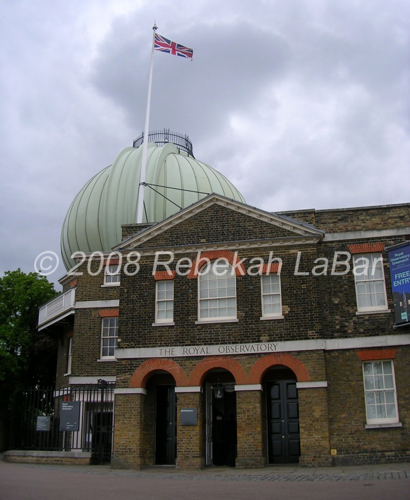
Universal Time, Coordinated (UTC) is the same time zone as Greenwich Mean Time (GMT). You probably already know that Greenwich Mean Time is the time at the Royal Observatory in Greenwich, London, England, where the prime meridian divides the eastern hemisphere from the western hemisphere.

Another time zone you may see on weather maps is Zulu Time (Z). Zulu (in South Africa) is also a place divided by the prime meridian, and as such Zulu Time is also the same time zone as UTC and GMT. While UTC may be the more formal way to write time in meteorology, many (including myself) prefer to use Z in informal settings as it is faster to write and say.
In summary,
- UTC = Z = GMT
- 24-hour time clock, like in the military
- Midnight GMT = 0000 UTC = 00Z
- Noon GMT = 1200 UTC = 12Z
- 7:30 PM GMT = 1930 UTC = 1930Z
US Time Zones
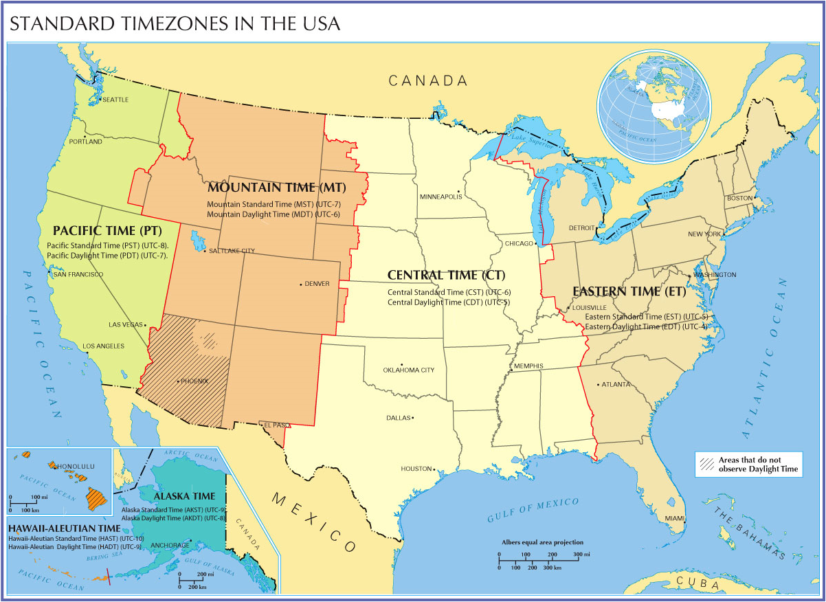
There are four time zones for the contiguous United States: Pacific, Mountain, Central, and Eastern. The following map (click to enlarge) shows the conversion factors between these time zones and UTC.

For example, I live in Oklahoma, so I’m currently in Central Standard Time. The conversion is UTC-6, which means if it is 1200 UTC / 12Z (noon in London), it is 6 am in Oklahoma. If I want to go to UTC, I have to go forward in time, and add six hours.
————————————————–
Next Monday we will start talking about weather measurements, beginning with surface observations!
Permalink
02.14.11
Posted in Weather Education at 8:00 am by Rebekah
Today’s post in the weather education series is on precipitation, one of the seven elements of weather (temperature, pressure, wind, moisture, clouds, precipitation, and visibility).
————————————————–
Last week we looked at clouds, including what they’re made of, how they form, and the different types. We said that clouds form when water vapor condenses/deposits on tiny particles (e.g., dust, smoke, salt) called cloud condensation nuclei / ice nuclei.
When those water droplets or ice crystals grow large enough, they will begin to fall out of the cloud.
Types of Precipitation
- Falling water droplet + other water droplets = coalescense, leading to rain
- Falling ice crystal + supercooled water droplets (liquid water existing below 0 °C or 32 °F) = accretion, leading to graupel (< 3 to 4 mm)…if the graupel gets lofted up in the cloud (more on this later), it may continue to collect water droplets and we will get hail
- Falling ice crystal + other ice crystals = aggregation, leading to snowflakes
- If the lowest layer of the atmosphere is warm enough (above 0 °C) and thick enough, the snowflakes can melt and will just fall as rain
- If there is a thick warm layer (above 0 °C) above a thin cold layer above the ground, the snow will melt but the raindrops will become supercooled, and you will get freezing rain as the liquid water freezes on contact with the ground
- If there is a thin warm layer (above 0 °C) above a cold layer above the ground, the snow will partially melt but then refreeze before hitting the ground as sleet
More info and illustrations on the temperature profiles needed for winter precipitation will come later in the series.
————————————————–
The final element of weather is visibility, but we will not treat this separately as it is dependent on other elements such as precipitation.
Next Monday we will move on to time zones!
Permalink
02.07.11
Posted in Weather Education at 8:00 am by Rebekah
Today’s post in the weather education series is on clouds, one of the seven elements of weather (temperature, pressure, wind, moisture, clouds, precipitation, and visibility).
————————————————–
Saturation
Last week we looked at moisture, including the different phases, transformations, and methods of measurement (e.g., dewpoint and relative humidity). Now, what happens when the relative humidity hits 100%?
When the air’s temperature equals the dewpoint, the relative humidity is 100% and we say the air is “saturated“. Air can only “hold” so much water vapor, and when it maxes out, some of the water vapor must condense into liquid water droplets or deposit ice crystals. This means saturation can result in dew, frost, fog, or clouds.
How can we attain saturation? The amount of water vapor the air can hold depends on the temperature. Warm air requires more moisture to reach saturation than cold air, so we can reach saturation by either adding more moisture or lowering the air temperature.
Cloud Formation
Clouds are composed of liquid water droplets or ice crystals. Water vapor doesn’t necessarily condense into pure liquid water droplets, though, but condenses onto tiny particles of dust, smoke, salt, etc., called cloud condensation nuclei (ice crystals form on ice nuclei).
Also, it is important to note that liquid water droplets may exist below 0 °C…these are called supercooled water droplets, and they can exist in liquid form at temperatures as low as -40 °C/F. Supercooled water droplets are important in many ways that we will see later (e.g., freezing rain, hail formation, thunderstorms, etc.).
Cloud Classification
Clouds are classified with Latin words based on their height and appearance…for example, high clouds have a “cirro-” prefix, clouds a bit further down in the atmosphere have an “alto-” prefix, clouds that are flattish have “strato-” or “stratus” in their name, clouds that are bubbly have “cumulo-” or “cumulus” in their name, and clouds from which precipitation is falling have “nimbo-” or “-nimbus” in their name.
- High clouds: cirrus, cirrostratus, cirrocumulus…usually reside above 6 km, mostly made up of ice crystals, thin and often very white, responsible for many optical effects such as sundogs and halos
- Middle clouds: altostratus, altocumulus…usually between 2 and 6 km, mostly made up of liquid water droplets, usually more gray in color, sun’s disk may be visible through them, but no halo
- Low clouds: stratus, stratocumulus, nimbostratus…usually below 2 km, mostly made up of liquid water droplets, the sun typically cannot be seen through these clouds
- Deep clouds: cumulus, cumulonimbus…clouds with more vertical development, including thunderstorm clouds (cumulonimbus)
There are also many other clouds names that may be affixed to one or another of the above cloud names, including “congestus” (deep cumulus clouds that haven’t quite made it to the cumulonimbus stage yet), “lenticularis” (lens-shaped clouds that are common above or just over mountain tops), and “mammatus” (pouch-shaped clouds common under thunderstorm anvils).
For photo examples of these clouds types, here are a couple of website suggestions to get you started: Weatherscapes Cloud Photo Gallery and Blue Hill Observatory Cloud Photo Gallery.
————————————————–
Come back next Monday as we talk about precipitation, the next element of weather.
Permalink
01.31.11
Posted in Weather Education at 8:00 am by Rebekah
Today’s post in the weather education series is on moisture in the atmosphere (e.g., phases, measurements, etc.), one of the seven elements of weather (temperature, pressure, wind, moisture, clouds, precipitation, and visibility).
————————————————–
Phases of Water
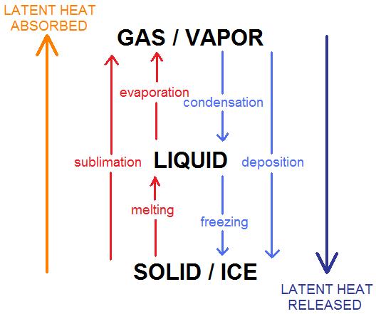
Water comes in three phases: gas (water vapor), liquid, and solid (ice). The following figure shows the names for the different phase changes.

Note that when water goes to a higher energy state (read: the molecules are moving faster so the temperature is higher), latent heat energy is absorbed, cooling the atmosphere.
Think about it: when you want to melt some ice, you have to apply some heat…but where does the heat go? The heat is absorbed by the ice, allowing it to melt and then leaving the environment cooler than it was before. Also, think about how you feel cooler when you get out of a pool: water droplets on your skin evaporate, drawing heat from your body and thus leaving you feeling cooler.
The reverse is true as well; when water goes to a lower energy state (e.g., ice to liquid or vapor), latent heat energy is released, warming the atmosphere.
Dewpoint vs. Relative Humidity
Atmospheric moisture can be measured in a variety of ways, the most common being dewpoint temperature and relative humidity.
Dewpoint temperature is an absolute measure of moisture, and the units are the same as those of air temperature (°F, °C, K). The dewpoint is basically the temperature at which the air would reach saturation, if the temperature were to drop. Thus, the higher the dewpoint, the higher the moisture. Dewpoints above 60 °F are indicative of humid conditions, while dewpoints below 40 °F are generally indicative of dry conditions.
Relative humidity is given as a percent, and as it is a relative measure of moisture, a higher relative humidity does NOT necessarily mean there is a high amount of moisture in the air…it ONLY means that the air is closer to saturation.
Think about it: if the air temperature is 30 °F, the dewpoint temperature must be less than or equal to 30 °F (remember, the dewpoint temperature can never exceed the air temperature). So even if the relative humidity is 90%, you still have dry air…it just means you might be close to saturation (maybe it’s foggy or snowing).

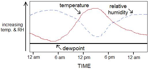
Now, let’s say the dewpoint temperature stays the same for 24 hours…what happens to the relative humidity? As the air temperature goes up, the relative humidity goes down (see figure, above)…as the air temperature rises during the day, the difference between the air temperature and the dewpoint becomes greater (thus the relative humidity goes down)…and as the air temperature falls at night, the difference between the air temperature and the dewpoint becomes less (thus the relative humidity goes up, and you may get dew on the grass).
————————————————–
Come back next Monday as we talk about clouds, the next element of weather.
Permalink
« Previous Page — « Previous entries « Previous Page · Next Page » Next entries » — Next Page »
