01.22.11
Posted in Weather News, Winter Weather at 8:00 am by Rebekah
National Weather Service offices in the Dakotas and Minnesota decided to start using a new type of warning this week, called an “extreme cold warning“.
An extreme cold warning will be issued when the air temperature is forecast to drop to 40 below zero and lower, with little or calm wind (previously only a wind chill warning could be issued for such cold temperatures, but this is meant to be more for when there is not much wind).
Thursday night, the NWS in Duluth had the chance to issue their first extreme cold warning, and it certainly verified; International Falls recorded a low of 46 below, tied for their 5th lowest temperature on record.
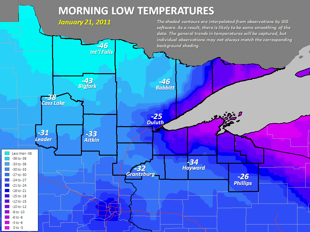
See more info about the cold on the NWS Duluth page here. See also the NWS link to more info on the experimental extreme cold warning.
Permalink
01.18.11
Posted in Non-US Weather, Weather News at 8:00 am by Rebekah
This week’s post in the global weather and climate series features Ushuaia, Argentina.
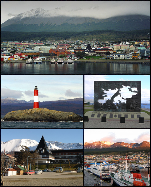
Montage of Ushuaia, Argentina, in the Tierra del Fuego. Source: Wikipedia
Ushuaia is the capital city of Tierra del Fuego Province, in southern Argentina. Widely regarded as the southernmost city in the world, Ushuaia is situated on the southern coast of Isla Grande de Tierra del Fuego, with the Martial Mountains to the north and the Beagle Channel to the south. Tierra del Fuego (in English, “Land of Fire”) is an archipelago on the southern end of South America; the southernmost point on the southernmost island is Cape Horn.
The island chain was first visited by Europeans (on Ferdinand Magellan’s voyage) in 1520, although natives had lived in this region for hundreds of years before then. British missionaries gave the city its name in the mid-1800s, as they were the first to really settle in Ushuaia. The population increased in the 1880s, following rumors of gold, but the rumors proved to be false. In 1896, a federal prison was established in Ushuaia; the president of Argentina had been pushing for the city to become a penal colony since 1873.
Today, Ushuaia has a (2010 estimated) population of 63,280. The primary economic activities include fishing, natural gas and oil extraction, sheep farming, and ecotourism.
A few more facts about Ushuaia:
- Time zone: Argentina Time (UTC-3)
- Average elevation: 16 feet (5 meters)
- Climate zone: Subpolar oceanic
- Average high temperature: 49 °F (9 °C)
- Average low temperature: 35 °F (2 °C)
- Average annual high/low temperature range: 40 to 57 °F (4 to 14 °C) / 29 to 42 °F (-2 to 5 °C)
- Record high temperature: 85 °F (29 °C)
- Record low temperature: -13 °F (-25 °C)
- Average annual precipitation: 21 inches (530 mm)
Weather: At nearly 55 °S, Ushuaia experiences short, cool summers and long, somewhat wet and cold winters. The climate of Tierra del Fuego may be compared to that of the Aleutian Islands. The southern tip of South America frequently gets hit by low-pressure systems, and this week is no different.
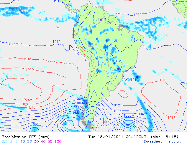
GFS model forecast for surface pressure and precipitation over South America this morning…note the lows (blue concentric circles) on the bottom of the map. Click to enlarge. Source: Weather Online UK
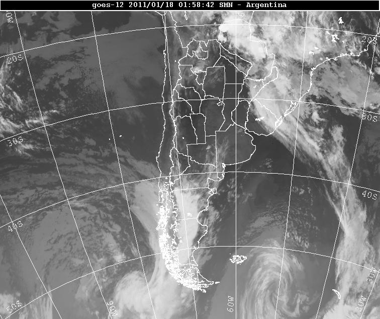
Infrared satellite image of southern South America from last night. Note the two swirls at the bottom of the image; those are the low-pressure systems (moving from west to east). Source: Servicio Meteorológico Nacional
There is a chance of rain every day and night this week for Ushuaia; but then again, the average number of rainy days per year for Ushuaia is 214. It is also pretty windy down there…winds this week may range from about 10 to 30 mph, mostly from the west. Temperatures are pretty typical for this time of year, with forecast highs in the lower 50s and lows in the upper 30s.
For weather maps and information on current and forecast Ushuaia weather, see the Servicio Meteorológico Nacional (Argentinian National Weather Service), Weather Underground, and Weather Online UK.
For more information on Ushuaia, here’s a link to Wikipedia.
Next Tuesday we will take a look at the climate and weather in another part of the globe. As always, if you have any suggestions for future cities, please leave a comment!
Permalink
01.15.11
Posted in Weather News at 8:00 am by Rebekah
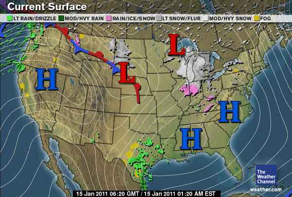
- Ridge over the western U.S.
- Positively tilted shortwave trough over Texas
- Shortwave trough over Ontario
- Ridge in the west, trough in the east pattern going to continue for a little while
- Rain continues to soak the Pacific Northwest
- Strong high remaining over the Great Basin
- Strong, arctic high over northwest Canada…going to bring cold, dry air into the Northern Plains and Midwest by mid-week
- Snow and ice falling in parts of the western Great Lakes area, in association with some lift around a weak low
- Surface high over the Southeast
Permalink
01.12.11
Posted in Tropical Weather, Weather News at 8:00 am by Rebekah
Last winter we experienced a moderately strong El Niño (see A Confused Robin and NWS Weather School), which was blamed in part for the snow and ice storms in the southern U.S. and the mild and dry weather in the Pacific Northwest (remember the winter Olympics?).
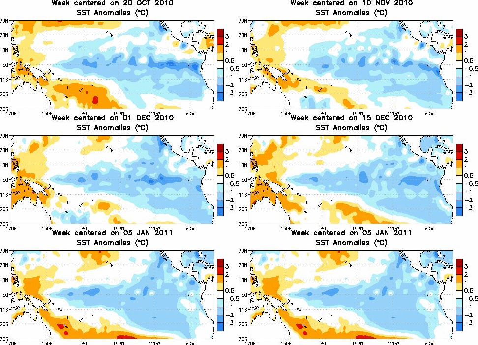
This winter, however, we are in the midst of a strong La Niña; one of the strongest on record, in fact.
What are El Niño and La Niña?
Normally, trade winds in the tropics blow from east to west. These winds push warm surface waters towards Australia (the western Pacific also has a lower typical surface pressure than the central Pacific, because of convergence occurring when the surface winds reach Australia and other islands). Near Peru, cold water rises up to take the place of the water that was pushed westward (this process is called upwelling).
During an El Niño, the trade winds weaken or possibly even reverse direction. Warm, tropical waters stay warm across the equatorial Pacific and upwelling decreases or stops.
La Niña is sort-of the opposite of an El Niño, where we just see “normal” go a little too far, in a manner of speaking, so upwelling is stronger and cold waters are colder than normal.
Current Events
Note in the figure above, from the Climate Prediction Center, the sea-surface temperatures across the tropics have lately been quite a bit cooler than normal, indicating a La Niña pattern.
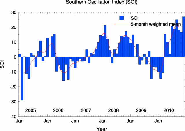
The Southern Oscillation Index (SOI), an Australian Bureau of Meteorology index for measuring the strength of El Niño / La Niña events (subtracts the surface pressure at Darwin, Australia from the surface pressure at Tahiti), has just recorded some of the highest positive (La Niña) values in history, including the highest value ever for December and the highest value since November 1973!
What does this mean for our weather?
Here’s a typical winter pattern for La Niña, from NOAA (bearing in mind that many other factors and ocean/pressure oscillations may affect the weather):
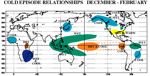
A couple of things to note: the Pacific Northwest was wetter than normal in December, but not necessarily cooler than normal. The Southwest and south central U.S. was warmer and drier than normal, but the Southeast (in fact all of the East) was quite a bit colder than normal and drier than normal. (To see recent climate maps, check out the CPC page here.)
Also, remember all the flooding going on in eastern Australia? Brisbane, the country’s third largest city, is currently bracing for record flooding. That’s due in some part to La Niña…various low-pressure systems and summer thunderstorms have aided in historic rainfalls and flooding. (Check out this video of cars being swept downstream in a flash flood in Toowoomba, Queensland.) Waters off the East Coast of Australia are also warmer than normal, which would help in producing convective showers.
Permalink
01.11.11
Posted in Weather News, Winter Weather at 9:06 pm by Rebekah
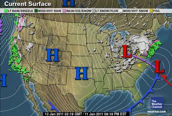
Tonight’s surface analysis from The Weather Channel shows most of the U.S. in the grips of a strong, large area of high pressure. This high pressure has ushered in cold, dry air for much of the U.S.
Perhaps the biggest story tonight, though, is that the low pressure center over Ohio, associated with a deep, upper-level trough, should merge late tonight with the low moving up the Atlantic Coast. This secondary low is what tracked along the Gulf Coast early in the week, aiding in the snow and ice storms of the Southeast.
As the smaller low moves up the coast tonight, an area of upper-level divergence on the east side of the trough (what’s causing the low in Ohio) will cause the surface low to intensify. The two areas of surface low pressure will appear to merge below the trough, and the pressure of the resulting surface low is expected to rapidly drop.
Models are showing that the pressure of this low could drop by 28 millibars in 24 hours, which is well within the definition of a “bomb cyclone” (low pressure center drop of 24 millibars in 24 hours). Currently, the pressure of both lows is about 1012 mb.
This extratropical cyclone / nor’easter is expected to result in several inches of snowfall across the Northeast, starting tonight.
In other news, there is also an extratropical cyclone off the Pacific Coast, and this is responsible for strong winds and rain and wintry precipitation along the West Coast. Western Washington and northwestern Oregon are already receiving snow and freezing rain.
Permalink
« Previous Page — « Previous entries « Previous Page · Next Page » Next entries » — Next Page »


