01.11.11
Posted in Non-US Weather, Weather News at 8:00 am by Rebekah
This week’s post in the global weather and climate series features Antananarivo, Madagascar.
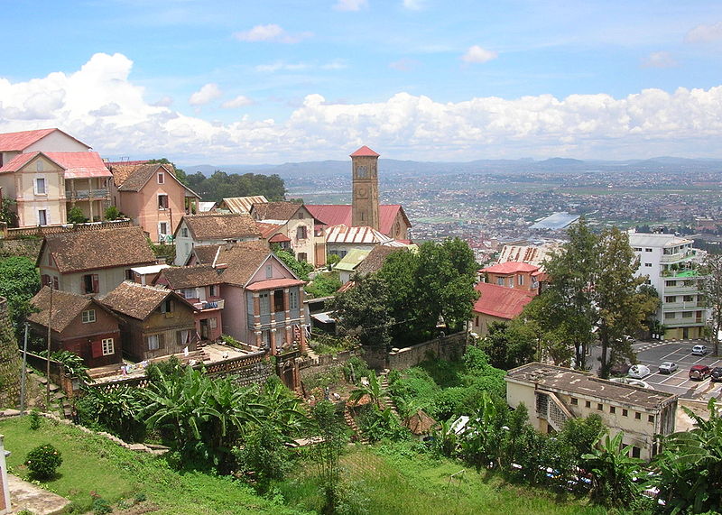
Looking down on Antananarivo, Madagascar. Source: Wikipedia
Situated on a mountain ridge, near the center of the island lengthwise and about 90 miles west of the eastern coast, Antananarivo is the capital of and the largest city in Madagascar. Founded in 1625, by the king of the Merina (an ethnic group from Madagascar), Antananarivo (formerly Tananarive) means “the city of the thousand”, taken from the number of soldiers assigned to guard it. In 1793, the city was made the capital of the Merina kingdom. About one hundred years later, Antananarivo was captured and colonized by the French. Madagascar finally gained independence from the French in 1960.
Today, Antananarivo is the economic and administrative center of Madagascar, with a population (in 2001) of 903,450 (1,403,449 in the metro). Exports include food, cigarettes, and textiles. Antananarivo is home to the University of Madagascar/Antananarivo, an Anglican cathedral and a Roman Catholic cathedral (as well as over 5,000 other church buildings), and Ivato International Airport (with service to Nairobi, Johannesburg, and Paris). Malagasy is the official language of Madagascar, though French is spoken there as well.
A few more facts about Antananarivo (from Wikipedia):
- Time zone: East African Time (UTC+3)
- Average elevation: 4,186 feet (1,276 meters)
- Climate zone: Temperate / subtropical highland
- Average high temperature: 75 °F (24 °C)
- Average low temperature: 57 °F (14 °C)
- Average annual high/low temperature range: 68 to 82 °F (20 to 28 °C) / 51 to 62 °F (10 to 17 °C)
- Record high temperature: 95 °F (35 °C)
- Record low temperature: 34 °F (1 °C)
- Average annual precipitation: 54 inches (1,365 mm)
Weather: At 18.5 °S, Antananarivo lies in the tropics of the Southern Hemisphere, thus the climate is warm and wet; however, the mountains keep the temperature milder than it would be otherwise. The coolest, driest months are from April to October.
Currently, every day this week is forecast to have a high near 82 and a low near 60. Scattered showers and thunderstorms are also forecast every day and night, with only a small amount of rain expected each day.
For weather maps and information on current and forecast Antananarivo weather, see Weather Underground and Weather Online UK.
For more information on Antananarivo, here’s a link to Wikipedia.
Next Tuesday we will take a look at the climate and weather in another part of the globe. As always, if you have any suggestions for future cities, please leave a comment!
Permalink
01.08.11
Posted in Weather Forecast, Weather News, Winter Weather at 8:00 am by Rebekah
Weather Discussion
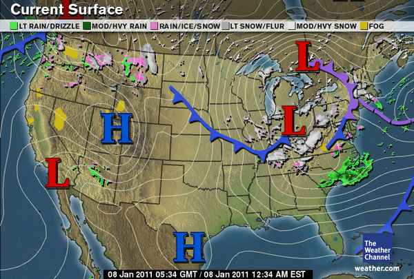
National: The primary features on satellite and upper-air maps are the large low-pressure system over the Northeast and the split-flow over the West, including a shortwave trough over the Northwest, a ridge over the northern Rockies, and a shortwave trough over the Southwest.
Rain and snow is ongoing in the Cascades and northern Rockies, a large surface high is located over the Great Basin, and the mature cyclone over the Northeast is bringing snow to New England and the Ohio River Valley. An arctic front extending across the central part of the country is bringing cold temperatures to the Plains as well as a chance for freezing rain and snow.
Southern Plains: The shortwave trough over the Southwest will dip down into Texas on Sunday, increasing lift and the chances for rain and snow in the wake of the cold front. Ground temperatures will probably be too warm for much snow accumulation; the greatest chance for snow would be in eastern Oklahoma, where temperatures are expected to be colder.
The type of precipitation is rather tricky to forecast for Oklahoma…forecast soundings for central Oklahoma Sunday evening show a saturated profile just at or below freezing. This means snow could fall, but if the temperature winds up just a little warmer than forecast, we could get just rain or even freezing rain. On the other hand, it looks a bit more certain that a snow/sleet event is building for the Arklatex region on Sunday and sleet/freezing rain for the Southeast on Monday and Tuesday.
On Monday, a trough will deepen over the Rockies and the exit region of a jet streak will be over Oklahoma. This will enhance lift and there will be another chance for some wintry precipitation. Forecast soundings for central Oklahoma again show saturated profiles just below freezing. Northern Oklahoma may get a bit more snow on this day.
The cooler weather will continue throughout the week…high temperatures in Oklahoma will primarily be in the 30s, with lows in the 20s. The latter half of the week should remain dry but breezy.
Permalink
01.04.11
Posted in Non-US Weather, Weather News at 8:01 am by Rebekah
This week’s post in the global weather and climate series features Rockhampton, Australia. Rockhampton is currently undergoing one of Australia’s worst flood events on record.
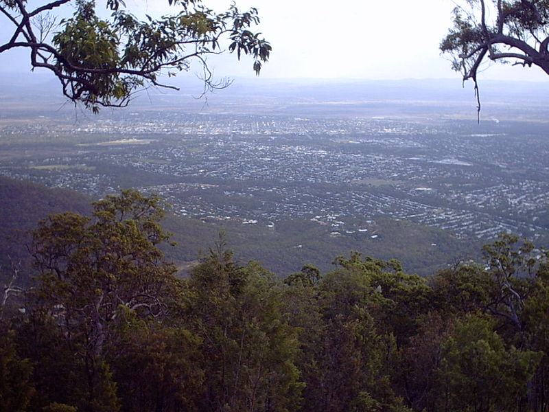
Rockhampton, from Mount Archer. Courtesy of Wikipedia.
Rockhampton is located in a hilly part of northeastern Australia, in the state of Queensland. Situated on the Fitzroy River, about 25 miles from the Coral Sea, Rockhampton lies just north of the Tropic of Capricorn.
Rockhampton was founded in the mid-1800s, as grazing lands and eventually gold attracted European settlers. Cattle continue to serve as a large part of the city’s economy, and Rockhampton promotes itself as the Beef Capital of Australia. The current population of the city is 76,729.

The Rockhampton Zoo features a Cassowary, naturally found only in New Guinea and far northeastern Queensland. A large, flightless bird, the Cassowary is smaller only than the ostrich and emu. Courtesy of Wikipedia.
A few more facts about Rockhampton (from Wikipedia):
- Time zone: Australian Eastern Standard Time (UTC+10)
- Average elevation: 37 feet (11.3 meters)
- Climate zone: Humid subtropical
- Average high temperature: 83 °F (28 °C)
- Average low temperature: 62 °F (17 °C)
- Average annual high/low temperature range: 74 to 90 °F (23 to 32 °C) / 49 to 72 °F (10 to 22 °C)
- Record high temperature: 114 °F (45 °C)
- Record low temperature: 30 °F (-1 °C)
- Average annual precipitation: 31 inches (799 mm)
Weather: Rockhampton is currently inundated, following copious amounts of rainfall during a tropical cyclone and various summer thunderstorms. The airport has been shut down (due to flooding) and only one escape route remains for the city. The water level in the Fitzroy River has reached 30 feet and is expected to go even higher by tomorrow, at which point the city should become completely isolated.
The area of Queensland that has been subject to the floods is greater than the size of Texas and greater than the size of France and Germany combined, with over 200,000 people being affected. Many people have had to leave their homes because the waters are too high. For more on the floods, see Sky News, BBC News, and MSNBC. Latest flood warning for the Fitzroy River.
Rockhampton experiences, on average, some 300 sunny days per year; however, there has been a trough of low-pressure situated over the Queensland coast for quite some time now, providing very rainy conditions. This setup is fairly common during La Niña years.
Unfortunately, as we are in a fairly strong La Niña, it does not look like Queensland will receive much relief from the rain any time soon. It may even take as long as a month before Queensland sees much relief from the rain and floodwaters.
For weather maps and information on current and forecast Rockhampton weather, see the Australian Bureau of Meteorology, Weatherzone, Weather Underground, and Weather Online UK.
For more information on Rockhampton, here’s a link to Wikipedia.
Next Tuesday I plan to take a look at the climate and weather in another part of the globe. As always, if you have any suggestions for future cities, please leave a comment!
Permalink
01.02.11
Posted in Severe Weather Post-analysis, Weather News at 8:01 am by Rebekah
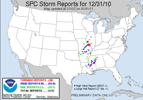
While 2010 had a slow start to the tornado season (see Where Have All The Tornadoes Gone?, Tornado Season So Far…, and Minnesota Leads U.S.; U.S. Back Near Average), it ended with a rare New Year’s Eve tornado outbreak.
40 tornadoes were reported between the morning of the 31st and the morning of the 1st. At least 7 people have died as a result of the twisters in Arkansas and Missouri.
Several of the tornadoes were rated EF3 on the Enhanced Fujita Scale, as lift from the big trough, warm, moist air ahead of an arctic cold front, and ample vertical wind shear provided the necessary conditions for strong tornadoes.
The last significant New Year’s Eve tornado outbreak occurred in 1947, when 20 people were killed and over 250 were injured.
So now that the year is over, how did 2010 stack up against the past few years in terms of tornadoes and tornado reports?
Tornado reports (2010 in red, ’05 to ’09 average in gray), from the Storm Prediction Center:
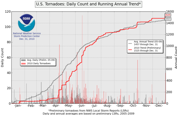
Note the year was below average until mid-July, at which point it fluctuated about the average and then ended just above average, with 1,525 tornado reports.
Tornado reports from ’05 through ’10, including the ’05 to ’09 average, in gray:
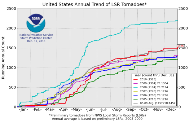
2010 was below the previous 5-year minimum until late April.
Adjusted tornado trend and percentiles (adjusted to account for over-reporting; for details on calculation, see SPC site):
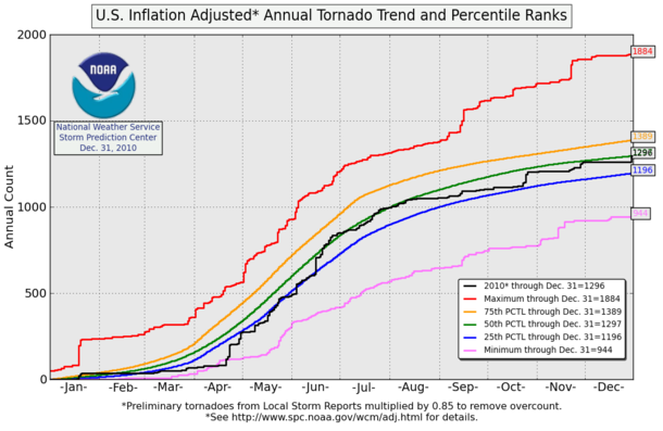
The estimated number of tornadoes in 2010 briefly dropped below the 1954 to 2007 minimum, before climbing up to just about the 50th percentile (the median). The year ended with an estimated 1,294 tornadoes.
For more detailed information on the New Year’s Eve 2010 tornado outbreak, check out the summaries/reports/photos from individual National Weather Service offices. Here are a few to get you started: Tulsa OK, St. Louis MO, Little Rock AR, and Jackson MS.
For more, go to the National Weather Service page and click on the area you are interested in.
Permalink
01.01.11
Posted in Weather News at 8:02 am by Rebekah
Happy New Year!
What are your favorite New Year’s traditions?
My favorite traditions include staying up the night before to ring in the New Year (usually by watching a certain glittery ball drop on TV and drinking sparkling cider), watching the Rose Parade in the morning, and watching football.
Unfortunately since I don’t have extended cable right now, I will not be able to watch (at least on TV) the Rose Bowl or watch Oklahoma beat UConn in the Fiesta Bowl. I’m disappointed that ESPN now has the rights to the BCS bowl games, though at least they are available to watch online.
Anyway, with regards to the Rose Parade, it looks like the weather in Pasadena will be fairly pleasant, although there is a slight chance for some rain.
In the history of the Rose Parade, going back to 1890, it has only rained on the parade 9 times!
The last time it rained on the parade was in 2006, and before that 1955.
The average high temperature for Pasadena on New Year’s Day is 67 °F (the average low is 44 °F).
The National Weather Service is calling for partly cloudy skies tomorrow with a high of 55 °F. Rain is not in the forecast until Sunday.
The Weather Channel is forecasting a high of 62 °F with partly cloudy skies and a 20% chance of rain.
Enjoy your holiday, however you spend it, and best wishes for a happy 2011!
Permalink
« Previous Page — « Previous entries « Previous Page · Next Page » Next entries » — Next Page »


