04.19.11
Posted in Non-US Weather, Weather News at 8:00 am by Rebekah
This week’s post in the global weather and climate series features Hanga Roa, Easter Island.
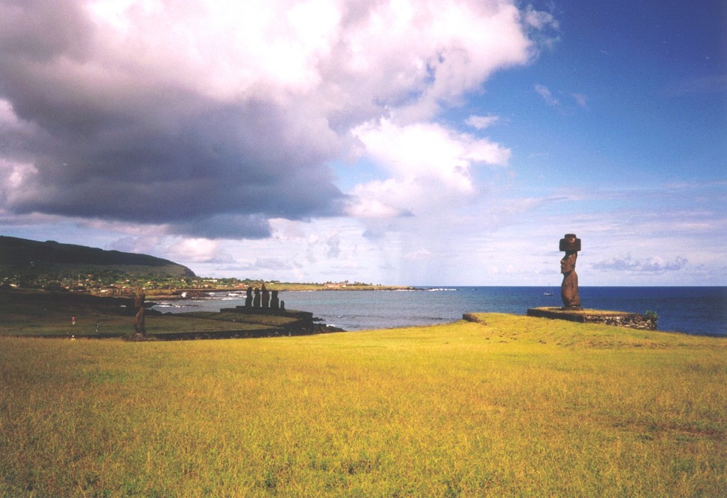
Hanga Roa, Easter Island, from Wikipedia
Hanga Roa (sometimes Hangaroa) is the main city and capital of Easter Island (aka Rapa Nui or Isla de Pascua), a territory of Chile. Easter Island is a small, Polynesian island in the southeastern Pacific Ocean, most famous for the monolithic human statues known as moai. The island got its name from the Dutch explorer Jacob Roggeveen, who on Easter Sunday 1722, became the first known European to land there.
Hanga Roa, on the southwest coast of Easter Island, is located at 27 °S. The island is nearly 1,300 miles east of Pitcairn Island, the nearest inhabited island, and nearly 2,200 miles east of Chile, making Easter Island one of the most isolated inhabited islands in the world. The population of Hanga Roa was 3,791 in 2002, making up 87% of the population of the entire island. Primary industries in the city include tourism, fishing, and farming. There is also an airport (the only airport on the island) and a multi-use stadium, home to the island’s football team.
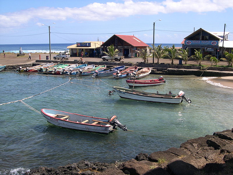
Hanga Roa harbor, from Wikipedia
A few more facts about Hanga Roa (from Wikipedia):
- Time zone: Standard Time (UTC – 6) or Daylight Saving Time (UTC – 5)
- Elevation: varies…begins at sea level, weather station at 167 ft (51 m)
- Climate zone: Humid subtropical
- Average high temperature: 73 °F (23 °C)
- Average low temperature: 66 °F (19 °C)
- Average annual high/low temperature range: 68 to 79 °F (20 to 26 °C) / 61 to 71 °F (16 to 21 °C)
- Average annual rainfall: 44 inches (1,125 mm)
Weather: Thanks to Hanga Roa’s location in the subtropics and on the coast of a small island, the temperature stays mild and fairly constant throughout the year. Precipitation is ample, but not as high as on islands in the southwestern Pacific.
Currently in the southern hemisphere fall, Hanga Roa is expecting highs around 77 °F, lows around 68 °F, and a slight chance of rain every day this week (personally, I think that might get a little boring after a while…but it could be a nice place to visit).
For weather maps and information on current and forecast Hanga Roa and Easter Island weather, see the Dirección Meteorológica de Chile, Weather Underground and Weather Online UK (global maps and models).
Here’s a Wikipedia link for Hanga Roa, and here’s a Wikipedia link for Easter Island.
Next Tuesday I may take a look at the climate and weather in another part of the globe, but I will be on my way down to Florida for the space shuttle Endeavour’s launch, so I might put the series on hold for another week or two. As always, if you have any suggestions for future cities, please leave a comment!
Permalink
04.13.11
Posted in Weather News at 8:00 am by Rebekah
…but with another chance for severe storms in eastern Oklahoma tomorrow, it’s hard to not get frustrated at the lack of rain in the rest of Oklahoma and Texas.
This drought seems similar to the one in 2006, in which there were many fires and not a great season for storm chasers. It’s a vicious cycle, as the lack of rain contributes to our inability to retain higher moisture content in the air, which prevents more thunderstorms from forming.
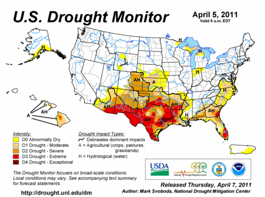
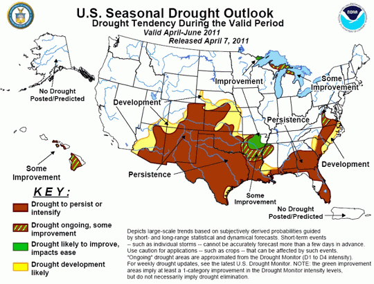
U.S. Drought Monitor and drought outlook, from the Climate Prediction Center. Note that dark brown (“drought to persist or intensify”) and the “persistence” label for much of the South for the next few months!
Parts of Oklahoma and Texas have already had problems with fires this year, and it doesn’t look like that is going to let up any time soon.
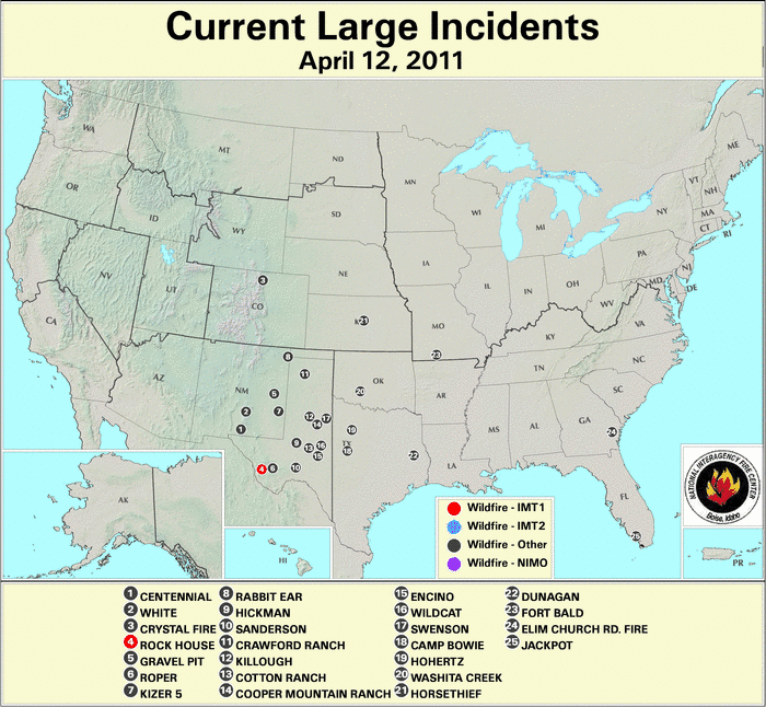
Large wildfires reported to the National Interagency Fire Center
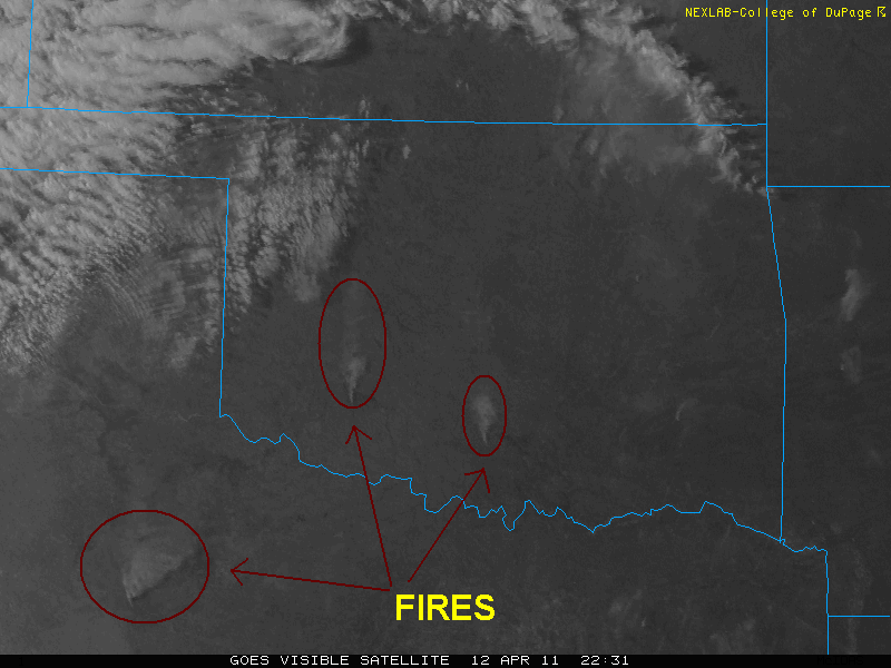
Smoke from wildfires visible on a visible satellite image yesterday.
Permalink
04.12.11
Posted in Non-US Weather, Weather News at 8:00 am by Rebekah
This week’s post in the global weather and climate series features Alice Springs, Northern Territory, Australia.
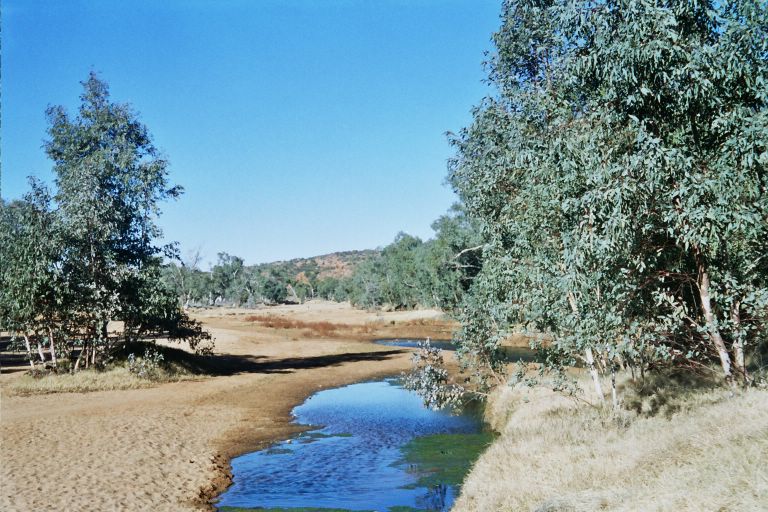
The springs that gave Alice Springs its name, from Wikipedia
Alice Springs is in the south central Northern Territory, near the center of Australia. This arid town is situated on the northern side of the MacDonell Ranges, a 400-mile-long series of mountain ranges in central Australia (the tallest is just over 5,000 feet).
Aborigines first came to this area thousands of years ago. Europeans began to settle in Alice Springs by the late 19th century, with the construction of a telegraph line and the discovery of gold. Until 1933, the town was known as Stuart (named for the first European to travel from southern to northern Australia).
Today, Alice Springs is home to nearly 28,000 people, and is primarily dependent on tourism.
Alice Springs hosts a number of sporting events, including the world’s only dry river race. The Henley-on-Todd Regatta, also known as the Todd River Race, is a race with bottomless boats in the sandy, dry riverbed of the Todd River (you HAVE to check out that webpage, it’s so interestingly bizarre). “Boats” are made of anything anyone can find, from metal frames with advertisements to washtubs to giant hamster wheels. Residents first came up with the idea to playfully mock the original British settlers and the British boat races, most notably the Henley Royal Regatta at Henley-on-Thames, England. In 1993, the Henley-on-Todd Regatta had to be cancelled, as there was actually water in the riverbed!

Henley-on-Todd Regatta, Alice Springs, from OzOutback
Another unique event is the Camel Cup, which consists of a series of races using camels instead of horses.
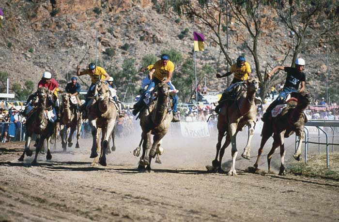
The Alice Springs Camel Cup, from Wikipedia
A few more facts about Alice Springs (from Wikipedia):
- Time zone: Australian Central Standard Time (UTC+9:30)
- Average elevation: 1,791 ft (545 m)
- Climate zone: Desert
- Average high temperature: 84 °F (29 °C)
- Average low temperature: 56 °F (13 °C)
- Average annual high/low temperature range: 68 to 98 °F (20 to 36 °C) / 39 to 71 °F (4 to 21 °C)
- Record high temperature: 113 °F (45 °C)
- Record low temperature: 19 °F (-8 °C)
- Average annual rainfall: 11 inches (282 mm)

Panorama of Alice Springs, from Wikipedia
Weather: Currently there is not much going on over central Australia weatherwise, except for a trough that should come through on Thursday and bring some clouds and cooler temperatures (but not rain). Alice Springs is pretty dry year-round, but southern winters are especially dry in this region.
This week the high temperatures are warming up from the lower 70s to the upper 80s by Thursday, before the trough arrives and pushes the highs back to the upper 70s by the weekend.
For weather maps and information on current and forecast Alice Springs and Australian weather, see the Australian Bureau of Meteorology, Weather Underground and Weather Online UK (global maps and models).
For a bit more information on Alice Springs, here’s a link to Wikipedia.
Next Tuesday I plan to take a look at the climate and weather in another part of the globe. As always, if you have any suggestions for future cities, please leave a comment!
Permalink
04.03.11
Posted in Weather News at 8:00 am by Rebekah
Lest some of us forget that it is not quite spring in all of the U.S.:
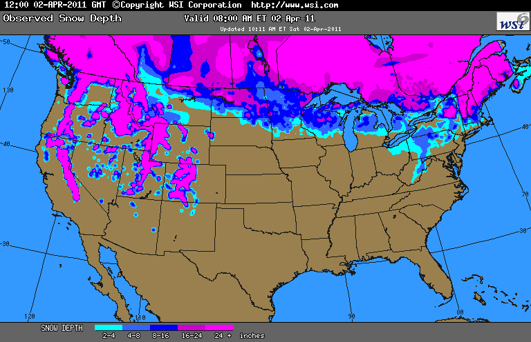
For those of you up north or in the mountains, I’m sorry.
This is what we’ve been enjoying down south lately (yesterday’s highs…today’s should be higher):
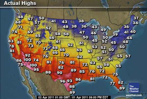
There is a slight risk of severe thunderstorms today, from eastern Oklahoma up through Illinois, but it doesn’t look like we’ll get anything even initiating down here, as the cap is too strong (i.e., temperatures are just too high, especially in the lower-levels of the atmosphere).
Still waiting to chase again!
Permalink
04.02.11
Posted in Weather News at 8:00 am by Rebekah
As a follow-up to yesterday’s drought monitor post, here’s a map showing the percent of normal U.S. precipitation from the past 30 days.
It’s a little grainy, but you can clearly see the well-below-normal precipitation over the south central and southwest U.S.!
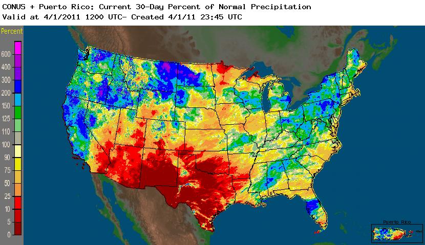
From the NWS: http://water.weather.gov/precip/
Permalink
« Previous Page — « Previous entries « Previous Page · Next Page » Next entries » — Next Page »


