04.01.11
Posted in Weather News at 8:00 am by Rebekah
Here’s a look at this week’s drought monitor (click to enlarge).
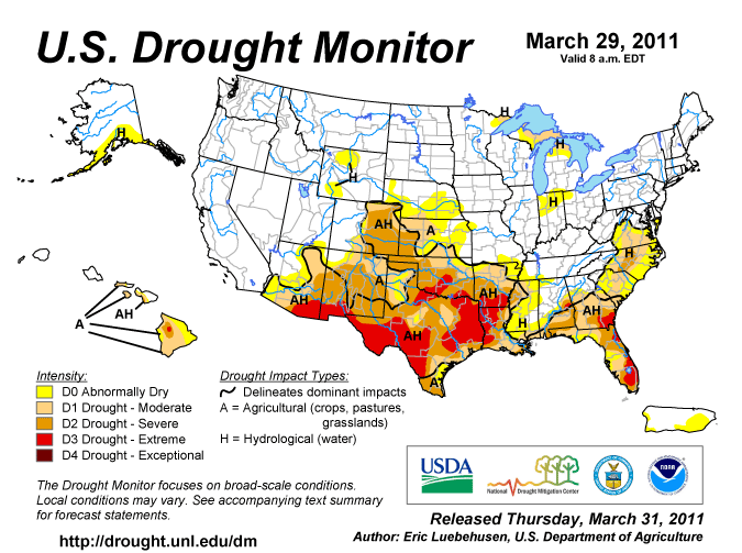
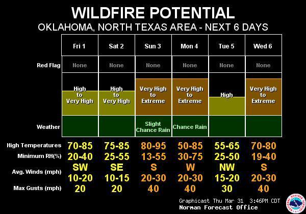
With warm and windy conditions expected to return to Oklahoma and north Texas this weekend, we could be in for another round of fires.
Here’s a Norman National Weather Service graphic showing our fire danger for the next few days.
Permalink
03.30.11
Posted in Weather News at 8:00 am by Rebekah
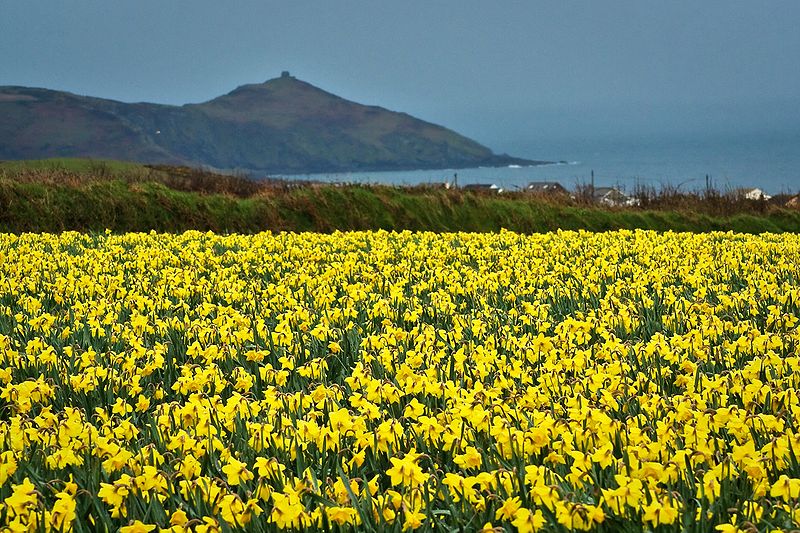
A field of daffodils in Cornwall, England. From Wikipedia
According to the BBC and various other news sources, daffodils in western England, East Anglia, and Scotland are blooming too early. Growers are having a difficult time getting enough people to come and pick the flowers, thus leaving many of the daffodils to go to waste.
Following a cold winter in the United Kingdom, warm, wet weather has allowed the daffodils to peak long before Easter, the most popular time for daffodil purchases (along with Mother’s Day, which is in early April this year in the UK). Easter comes three weeks later this year than last year, and the daffodils are expected to be past their prime by then.
The UK grows over 25,000 varieties of daffodils, exporting many of them to countries such as Denmark, Germany, Holland, and Sweden. The UK produces half of the world’s daffodil bulbs and exports 10,000 tons of daffodil bulbs each year.
The UK Met Office is forecasting high temperatures across England today from about 10 to 13 °C (50 to 55 °F), tomorrow 12 to 17 °C (54 to 63 °F), Friday 12 to 18 °C (54 to 64 °F), and Saturday 13 to 20 °C (55 to 68 °F).
Permalink
03.29.11
Posted in Non-US Weather, Weather News at 8:00 am by Rebekah
This week’s post in the global weather and climate series features Nairobi, Kenya.
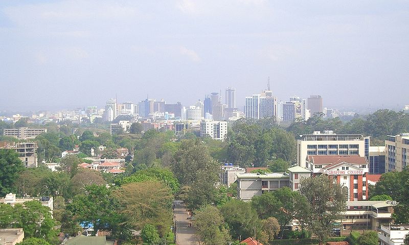
Nairobi skyline, from Wikipedia
Nairobi, just south of the equator, lies on the Nairobi River in south central Kenya. Kenya borders Lake Victoria and the Indian Ocean. Founded as a rail depot in 1899, Nairobi quickly grew and became the capital of British East Africa in 1907.
Today, Nairobi is the capital of and largest city in Kenya, as well as the largest city in east Africa. The population (2009 census) is 3.1 million. Well off financially, Nairobi welcomes many tourists each year. The primary tourist destination is the Nairobi National Park, including giraffes, lions, and rhinos. Nicknames for the city include “The Green City in the Sun” (from the vegetation and warm climate) and “Safari Capital of the World” (from the popular safari tourism).
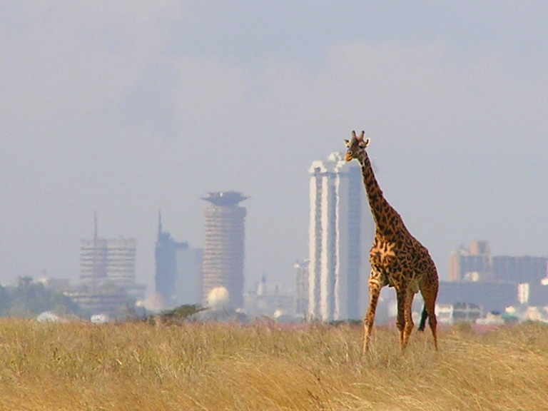
A giraffe in Nairobi National Park, bordering the city of Nairobi in the background. From Wikipedia
A few more facts about Nairobi (from Wikipedia):
- Time zone: East Africa Time (UTC+3)
- Average elevation: 5,450 ft (1,661 m)
- Climate zone: Subtropical highland
- Average high temperature: 74 °F (23 °C)
- Average low temperature: 54 °F (12 °C)
- Average annual high/low temperature range: 69 to 78 °F (21 to 26 °C) / 50 to 57 °F (10 to 14 °C)
- Average annual precipitation: 40 inches (1,024 mm)
Weather: As Nairobi is near the equator, the city experiences fairly warm daytime temperatures throughout the year. However, the city is over a mile above sea level, so nights can be quite cool.
The rainiest months of the year are March through May and November through December.On average, the months of July and August each receive less than one inch of rain.
We’re going into the wettest month; April receives, on average, 8.6 inches of rain over 16 rainy days.
This week is forecast to be especially warm for the area, with highs in the low 80s and lows near 60 °F. Rain is in the forecast for Tuesday through Thursday (it has already been raining there for at least the past week).
For weather maps and information on current and forecast Nairobi and Kenya weather, see the Kenya Meteorological Department, Weather Underground and Weather Online UK (global maps and models).
For a bit more information on Nairobi, here’s a link to Wikipedia.
Next Tuesday I plan to take a look at the climate and weather in another part of the globe. As always, if you have any suggestions for future cities, please leave a comment!
Permalink
03.22.11
Posted in Non-US Weather, Weather News at 8:00 am by Rebekah
This week’s post in the global weather and climate series features Palma, Mallorca, in the Balearic Islands of Spain.
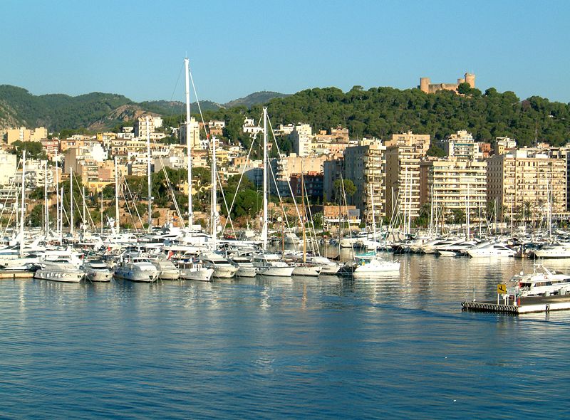
Harbor of Palma, with Bellver Castle in the background, from Wikipedia
The city of Palma was founded by the Romans back in 123 BC, so as you can imagine, the town (and the island) has gone through a long history, between the Romans, the Muslims, the Moors, the Vikings, the Spanish, etc.
Palma is situated on the southwest coast of the island of Mallorca (sometimes spelled Majorca). Mallorca is one of several islands belonging to the Balearic Islands, off the east coast of Spain in the Mediterranean. The Balearic Islands are part of Spain. Palma (also known as Palma de Mallorca), the capital of the Balearic Islands, is now home to about 401,270 people.
Tourism plays a large part in the economy of the islands; in 2010, over 6 million people came to visit tourist resorts on the island of Mallorca (according to Wikipedia). Mallorca is about 1,400 square miles in size (about 3,600 square km).
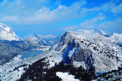
Serra de Tramuntana, a southwest-northeast mountain range on the northern coast of Mallorca; the highest point, Puig Major, is 4,741 ft tall (1,445 m). From Wikipedia
A few more facts about Palma (from Wikipedia):
- Time zone: Central European Time (UTC+1) or Central European Summer Time (UTC+2)
- Average elevation: 43 ft (13 m)
- Climate zone: Mediterranean (warm, dry summers; mild, wetter winters)
- Average high temperature: 71 °F (22 °C)
- Average low temperature: 58 °F (14 °C)
- Average annual high/low temperature range: 59 to 85 °F (15 to 30 °C) / 47 to 72 °F (8 to 22 °C)
- Average annual precipitation: 17 inches (427 mm)
Weather: June through August are the driest months of the year in Palma; every other month receives between 1 and 2.7 inches of precipitation. We are starting to go into the drier period, and temperatures are currently pretty seasonable.
Temperatures this week are expected to start out a little lower, with highs near 60 °F, but will rise up to 70 °F by Saturday. Lows this week will be in the mid-40s to near 50 °F.
There is a chance of rain today and tomorrow, but then it should dry up for the rest of the week. They have been getting a mostly east wind lately, as there is a rather large high pressure system sitting over Europe at present.
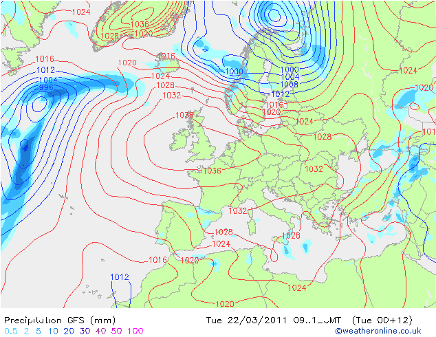
GFS model from 00Z run; valid for 12Z (1 pm local time). Map shows surface pressure and 3-hour precipitation. From Weather Online UK
For weather maps and information on current and forecast Palma, Mallorca, and Balearic Island weather, see the Agencia Estatal de Meteorología (Spain’s national weather service; good if you understand Spanish, though there is a semi-English version), Weather Underground and Weather Online UK (global maps and models).
For a bit more information on Palma, here’s a link to Wikipedia. Here is the city’s website (in Spanish).
Next Tuesday I plan to take a look at the climate and weather in another part of the globe. As always, if you have any suggestions for future cities, please leave a comment!
Permalink
03.20.11
Posted in Weather News at 8:00 am by Rebekah
Happy first day of spring!
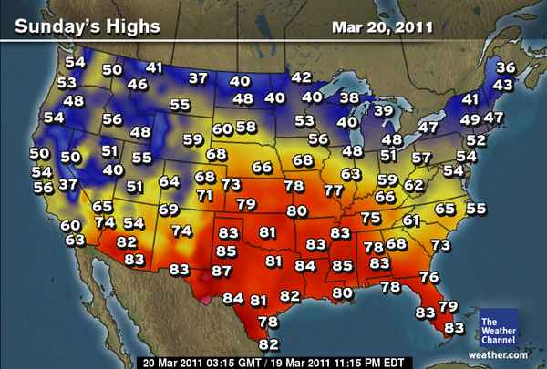
Here’s a look at today’s forecast highs from The Weather Channel.
Temperatures will be well above average from the Mississippi Valley into the Plains, but near or below average for the West Coast and the Northeast.
Permalink
« Previous Page — « Previous entries « Previous Page · Next Page » Next entries » — Next Page »


