03.19.11
Posted in Severe Weather Post-analysis, Weather News at 8:00 am by Rebekah
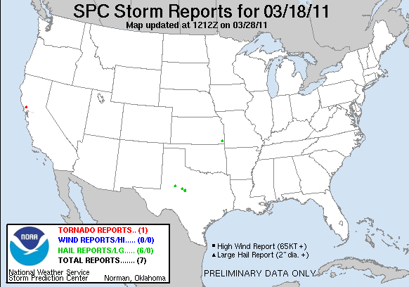
Yesterday morning a tornado or two touched down not far north of the San Francisco Bay.
The one storm report showing up right now on the Storm Prediction Center site is for a tornado at 1615Z (9:15 am Pacific Time) in Santa Rosa, California. The report said “EF1 tornado completely destroyed metal building and severely bent metal gate.”
I also heard that there may have been another tornado yesterday over the water, making it a waterspout.
While there were a few tornado-warned supercells around the Bay Area, the primary severe weather threat in the area was for high winds.
Permalink
03.17.11
Posted in Weather News at 8:00 am by Rebekah
Happy St. Patrick’s Day!
Here’s the 6 to 10 day Climate Prediction Center temperature outlook, valid for Tuesday through Saturday of next week:
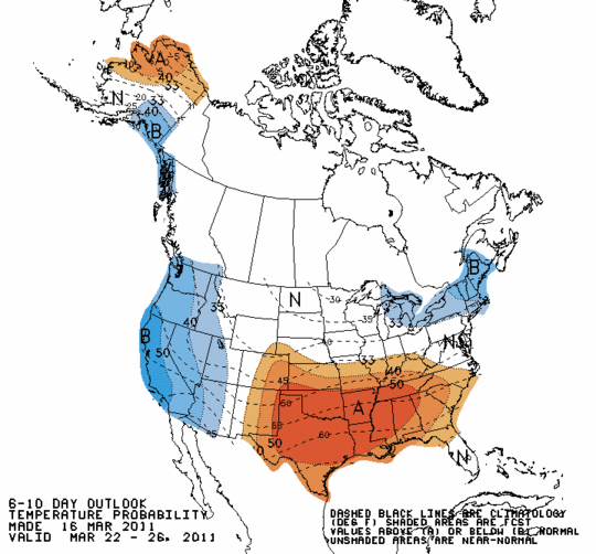
Note that below normal temperatures are still expected for the western U.S. as well as the far Northeast, while above normal temperatures are expected for the south central to southeastern U.S.
Now take a look at the precipitation outlook for the same period:
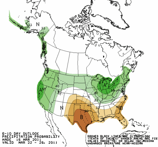
Above normal precipitation areas include the western and northern U.S., especially northern California and the Great Lakes region. Below normal precipitation is expected to continue in the south central and southeastern U.S.
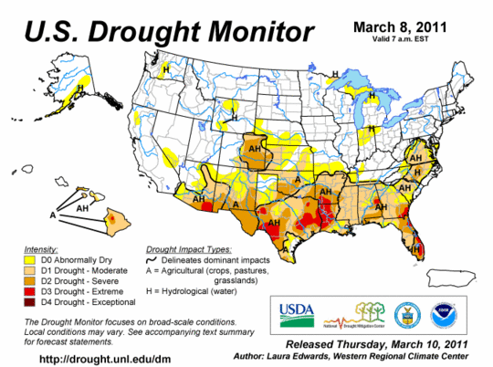
Unfortunately, there is no relief in the near future for areas that need rain and those that don’t. Last week’s drought monitor (there should be a new one coming out today) showed the drought in the southern U.S.
Earlier this week we got a few sprinkles in central Oklahoma, which went on to form a decent line of showers in southeastern Oklahoma. The sound of rain seemed so foreign to me that I wasn’t sure at first what I was hearing out my window. 🙂
A number of the southern states could sure use some more rain soon.
It does appear that there may be some hope of thunderstorms in the southern into the central Plains early next week, but it’s a little too early to be sure right now as the western trough seems to move a little slower with each model run.
Permalink
03.15.11
Posted in Non-US Weather, Weather News at 8:00 am by Rebekah
This week’s post in the global weather and climate series features Sendai, Japan, one of the hardest-hit cities by last week’s 9.0 earthquake and ensuing tsunami.
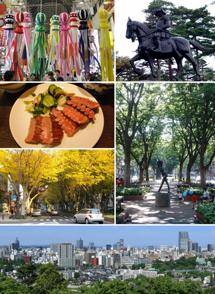
Montage of Sendai, from Wikipedia
Founded in 1600, Sendai, known also by its nickname “The City of Trees”, is the capital of Miyagi Prefecture in Japan. The city is situated on the northeastern coast of Japan’s largest island, Honshu, and stretches from the Pacific Ocean to the Ōu Mountains. The highest point in the city is Mount Funagata (about 4,950 feet, or 1,500 meters tall). Sendai has a population of just over 1 million.
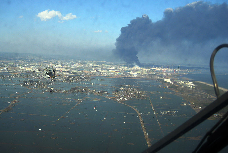
On Friday, March 11, a 9.0-magnitude earthquake and a tsunami of up to 33 feet (10 meters) tragically affected Sendai and many nearby cities. The following image, from Wikipedia (taken by the U.S. Navy), shows Sendai after the tsunami.
A few more facts about Sendai (from Wikipedia):
- Time zone: Japan Standard Time (UTC+9)
- Elevation: near sea level, but hilly
- Climate zone: Humid subtropical (cool, relatively dry winters and warm, wet summers)
- Average high temperature: 61 °F (16 °C)
- Average low temperature: 47 °F (9 °C)
- Average annual high/low temperature range: 41 to 82 °F (5 to 28 °C) / 28 to 70 °F (-2 to 21 °C)
- Average annual precipitation: 49 inches (1,242 mm)
- Average annual snowfall: 35 inches (90 cm)
Weather: The weather station in Sendai, located at Sendai Airport, stopped reporting as soon as the tsunami struck it, presumably damaging or destroying the instruments if not carrying them away. That being said, temperatures in the area have been fairly cool and typical for this time of year.
Currently, the primary surface feature near Japan is a surface low sitting off the east coast of the country, and this low will rapidly strengthen as it moves to the northeast.
Highs in Sendai this week will be around 40 °F until Saturday, when the temperature is expected to warm up to the mid-50s. Lows will range from the mid-20s to near 30 °F. There is a slight chance of some rain and snow almost every day and night this week (the greatest chance for snow is tonight).
Please keep the people of Japan and everyone affected by the recent disaster in your thoughts and prayers, including the aid workers and those working tirelessly and bravely to keep the nuclear damage at a minimum.
For weather maps and information on current and forecast Sendai weather, see the Japan Meteorological Agency, Weather Underground and Weather Online UK (maps and models).
For a bit more information on Sendai, here’s a link to Wikipedia
Next Tuesday I plan to take a look at the climate and weather in another part of the globe. As always, if you have any suggestions for future cities, please leave a comment!
Permalink
03.13.11
Posted in Weather News at 8:00 am by Rebekah
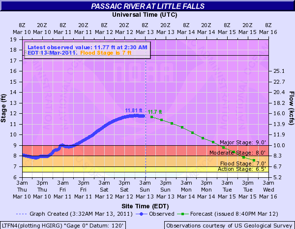
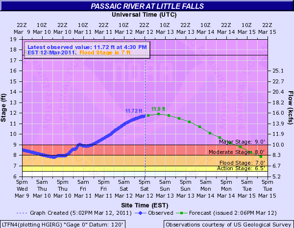
The Passaic River, in northern New Jersey, reached peak flood stage last night. The river gauge at Little Falls, New Jersey, recorded the 5th highest flood peak since records began.
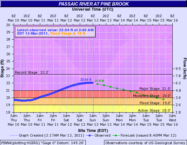
Here are a couple of hydrographs from the Passaic River when it was near peak.
Little Falls (click to enlarge; click here to view the latest hydrograph and info for this station):
Pine Brook (click to enlarge; click here to view the latest hydrograph and info for this station):
Many other rivers in the Northeast rose quite a bit as well, forcing hundreds of people from their homes. The flood waters in some parts of northern New Jersey are not expected to recede for a few days.
The rivers have been rising as a result of heavy rains recently, on top of snow that is melting with more springlike temperatures. Much of the area affected should be rain-free for a little while now, though, and the river levels have already begun to drop.
Permalink
03.12.11
Posted in General News, Weather News at 8:00 am by Rebekah
Yesterday was a pretty wild day, from the Japanese earthquake and the Pacific tsunami to wildfires in Oklahoma and Texas and flooding in the Northeast.
Here are some U.S. tsunami amplitudes I found via the National Weather Service (note the amplitude is the height above normal sea level):
LOCATION – TIME – AMPLITUDE
———————————————–
PORT ORFORD OR – 1724UTC – 6.1FT/1.85M
ADAK AK – 1755UTC – 3.6FT/1.09M
KODIAK AK – 2211UTC – 0.9FT/0.28M
LOS ANGELES CA – 2115UTC – 1.7FT/0.51M
SAN DIEGO CA – 2131UTC – 1.7FT/0.51M
LA JOLLA CA – 2007UTC – 1.4FT/0.43M
WESTPORT WA – 1920UTC – 2.0FT/0.62M
ST PAUL IS. AK – 1228UTC – 2.1FT/0.65M
OLD HARBOR AK – 2154UTC – 1.1FT/0.33M
DUTCH HARBOR AK – 1204UTC – 1.3FT/0.41M
SHEMYA AK – 1136UTC – 5.2FT/1.58M
ARENA COVE CA – 1834UTC – 8.7FT/2.65M
CRESCENT CITY CA – 1656UTC – 8.2FT/2.49M
SAN FRANCISCO CA – 1749UTC – 2.1FT/0.64M
MONTEREY HARBOR CA – 2013UTC – 2.4FT/0.72M
NORTH SPIT CA – 1639UTC – 3.3FT/1.01M
PORT SAN LUIS CA – 1745UTC – 8.6FT/2.64M
SANTA BARBARA CA – 2229UTC – 3.2FT/0.97M
SANTA MONICA CA – 2223UTC – 2.8FT/0.84M
————————-
In other news, the Passaic River is still nearing its crest, now expect to peak around 12 feet tonight.
Also, Oklahoma yesterday was going up in flames (as well as parts of Texas and Colorado); the governor declared a state of emergency for the entire state, as we had at least three dozen or so wildfires burning as a result of strong winds (gusting to 47 mph), temperatures near 80, and very dry conditions. Several grass fires wound up burning a few homes, as firefighters were having a very difficult time trying to get these fires under control.
Permalink
« Previous Page — « Previous entries « Previous Page · Next Page » Next entries » — Next Page »


