03.01.11
Posted in Non-US Weather, Weather News at 8:00 am by Rebekah
This week’s post in the global weather and climate series features Tripoli, Libya.
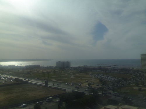
Looking over Tripoli to the Mediterranean. From Wikipedia
Tripoli is situated in the northwest part of Libya, on the Mediterranean Coast and the edge of the desert. Founded by the Phoenicians in the 7th century BC, Tripoli has had a long and rich history, between at least the Phoenicians, Greeks, Romans, Spanish, Turks, and Italians.
Today, the Tripoli metro area is home to 1,065,405 people (as of 2006). The capital of and largest city in Libya, Tripoli has been ground zero for the protests and revolts against the government and the leader of the country, Gadhafi. Tripoli is also the largest commercial and manufacturing center in Libya.
A few more facts about Tripoli (from Wikipedia):
- Time zone: Eastern European Time (UTC+2)
- Average elevation: 266 ft (81 m)
- Climate zone: Mediterranean
- Average high temperature: 78 °F (25 °C)
- Average low temperature: 60 °F (16 °C)
- Average annual high/low temperature range: 64 to 91 °F (18 to 33 °C) / 48 to 73 °F (9 to 23 °C)
- Average annual precipitation: 13 inches (334 mm)
Weather: Tripoli’s climate is Mediterranean, meaning it has warm, dry summers and cool winters with modest rainfall. This week Tripoli’s highs are in the low to mid-60s with lows in the mid- to upper 40s.
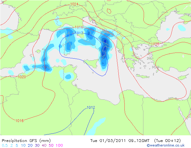
GFS forecast map for 1200 UTC today, showing low surface pressure over Italy, north of Libya (the filled contours indicate 3-hour precipitation). From Weather Online UK
For weather maps and information on current and forecast Tripoli weather, see Weather Underground and Weather Online UK (maps and models).
For more information on Tripoli, here’s a link to Wikipedia.
Next Tuesday I plan to take a look at the climate and weather in another part of the globe. As always, if you have any suggestions for future cities, please leave a comment!
Permalink
02.26.11
Posted in Weather News, Winter Weather at 8:00 am by Rebekah
The last few days have brought cold temperatures and snow to the Pacific Northwest. Even western Washington and northwestern Oregon received a rare few inches of snow, prompting a visit to Seattle from The Weather Channel’s meteorologist Chris Warren.
The trough associated with this storm system is dipping a bit further south into central California this morning, where cold air will advance behind a front and surface low moving over the Great Basin.
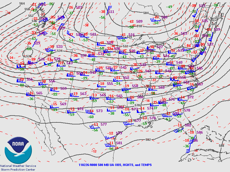
Friday night’s 500 mb analysis from the Storm Prediction Center, showing the trough over the West Coast.
This cold air is bringing snow early this morning down to at least 1000 feet in the San Francisco Bay Area, and it is even possible that a few flakes may fall at sea level in the Bay Area. As of 11 pm Pacific Time last night, light snow was already confirmed in the San Francisco metro.
It has not snowed in downtown San Francisco since February 1976.
Record cold and a few inches of snow is also forecast for southern California, as a stream of moisture is coming up from the tropics (the Pineapple Express); snow levels in the Los Angeles area could drop to 500 feet.
Record lows were set Friday morning in Seattle, Washington (21 °F) and Billings, Montana (-14 °F), and more records could be broken tomorrow morning. A few examples of California record lows that may be threatened (info from The Weather Channel) include Los Angeles (38 °F), Long Beach (37 °F), and Sacramento (28 °F).
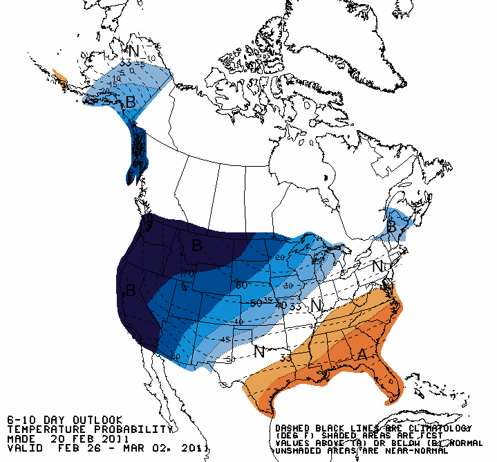
Climate Prediction Center outlook for temperatures from today through Wednesday, showing well below average temperatures expected across the West Coast.
Note also that this unusual cold follows record California warmth earlier in February (e.g., San Francisco experienced some 70 and 80-degree weather).
Permalink
02.23.11
Posted in Weather News at 8:00 am by Rebekah
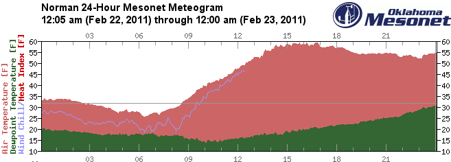
The Oklahoma Mesonet is a network of 120 environmental observing stations distributed across Oklahoma. Sometimes (if not most of the time), the Oklahoma Mesonet, run by the Oklahoma Climatological Survey, can be more accurate than the National Weather Service observing stations.
Yesterday, the Norman National Weather Service station was having issues…including a temperature range of -20 °F to 86 °F (it was actually in the 50s) and a dewpoint range of -42 °F to 45 °F (actually all in the 20s)!!
The following meteograms show temperature and dewpoint for Norman from about midnight last night through midnight this morning. Check out that temperature drop and spike on the NWS version! Note the dewpoint drops off a couple times on the NWS meteogram…no data was recorded these two times, but then it came back with a reading of -42 °F!
NWS Norman station; click to enlarge (based on a meteogram from the University of Wyoming; temperature [pink] and dewpoint [green] given on the side scales, local time and hourly temperature given below):

Oklahoma Mesonet Norman station:
Permalink
02.22.11
Posted in Non-US Weather, Weather News at 8:00 am by Rebekah
This week’s post in the global weather and climate series features Manaus, Amazonas, Brazil.
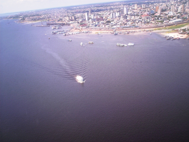
Aerial view of Manaus, looking over the Rio Negro. From Wikipedia
Manaus is a city of over 1.7 million people (over 2 million in the metro), lying at the confluence of the Negro and Amazon rivers. The capital of the Brazilian state of Amazonas, Manaus is located in the heart of the Amazon Rainforest and is a popular ecotourist destination. Manaus makes up 50% of the population of the Amazon.
Manaus was founded as a fort in 1669, to help establish the Portuguese claim on the area. In the late 19th century, Manaus was at the center of the rubber boom of the Amazon. Current exports include timber and Brazil nuts, while petroleum refining, soap manufacturing, shipbuilding, chemical industries, and tourism are also a part of the economy.
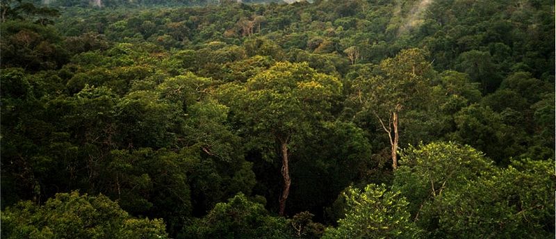
Amazon Rainforest, on the north side of Manaus. From Wikipedia
A few more facts about Manaus (from Wikipedia):
- Time zone: Atlantic Standard Time (UTC-4)
- Average elevation: 302 ft (92 m)
- Climate zone: Tropical rainforest
- Average high temperature: 86 °F (30 °C)
- Average low temperature: 73 °F (23 °C)
- Average annual high/low temperature range: 86 to 90 °F (30 to 32 °C) / 73 to 75 °F (23 to 24 °C)
- Record high temperature: 99 °F (37 °C)
- Record low temperature: 55 °F (13 °C)
- Average annual precipitation: 66 inches (1,670 mm)
Weather: As Manaus is situated at just 3 °S and in the middle of a rainforest, the climate is pretty steady year-round. As you can see by the climate stats above, the temperature really doesn’t range outside of the low to mid-70s at night to the upper 80s during the day. Makes for an easy forecast! There is a distinct rainy season, though; the wettest months are December through May.
This week the forecast is calling for…you guessed it, lows around 73 °F and highs around 84 °F, with a chance of rain every day.
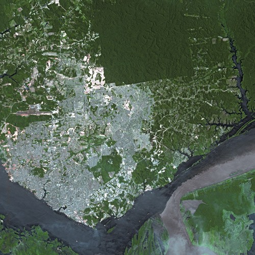
Satellite view of Manaus, showing the Rio Negro (left) flowing into the Amazon River (going off to the right). From Wikipedia
For weather maps and information on current and forecast Manaus weather, see Weather Underground and Weather Online UK (maps and models).
For more information on Manaus, here’s a link to Wikipedia.
Next Tuesday I plan to take a look at the climate and weather in another part of the globe. As always, if you have any suggestions for future cities, please leave a comment!
Permalink
02.19.11
Posted in Non-US Weather, Tropical Weather, Weather News at 8:00 am by Rebekah
Ex-Tropical Cyclone Carlos just keeps on dancing down the northwestern coast of Australia!
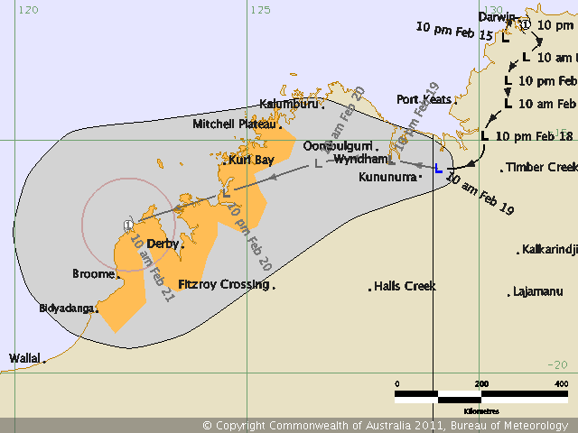
This is so strange…the tropical low was upgraded to tropical cyclone as soon as it moved OFF the coast (would that be a…waterfall? :)), then it came back onshore, swirled around Darwin and dumped over 2 feet of rain on the area in about 3 days (over half the average February rainfall). Now it’s still being recognized as a tropical low. Carlos is close to making it offshore again, but really has the best chance in a couple of days, when the low could become a Category 1 cyclone again.
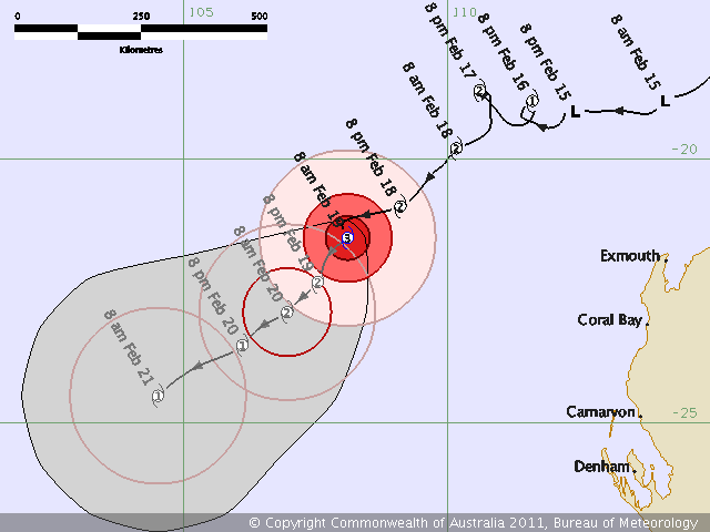
Oh, and in the meantime, Category 3, Severe Tropical Cyclone Dianne is off the west coast of Australia, actually acting more in character for a tropical cyclone (well, except for the couple of little loop-de-loops the Bureau of Meteorology had her taking). Dianne isn’t expected to make landfall, but to gradually weaken.
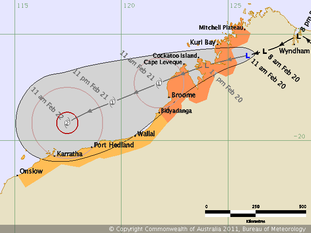
EDIT: The Bureau of Meteorology now has Carlos getting to a Category 2!
Permalink
« Previous Page — « Previous entries « Previous Page · Next Page » Next entries » — Next Page »


