02.01.11
Posted in Weather News, Winter Weather at 3:58 pm by Rebekah

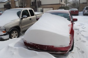
The blizzard has struck Oklahoma…my first blizzard was a pretty big one, and by now the worst is up around Missouri and Illinois.
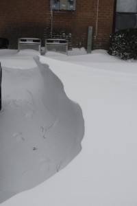
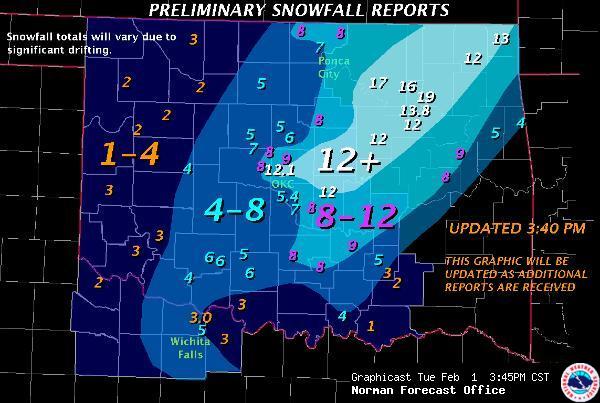
I measured about 8 or so inches of snow here in Norman, but it’s difficult to measure just how much snow we would have gotten without the strong winds. I found quite a few 2-foot snow drifts, and some drifts that were around or just over 3 feet deep!
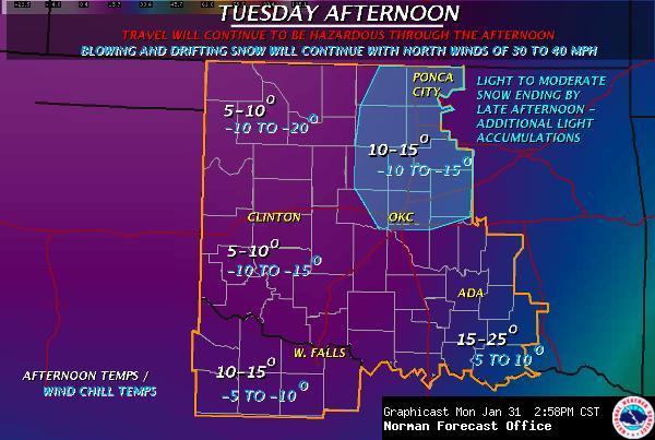
The wind has really been howling, at about 30 mph or greater, with gusts to 40 mph. The temperature this afternoon when I went out was around 10 °F, with a wind chill of -15 °F!

Last night we got some heavy thundersleet (with quite a bit of lightning!), starting about 9:15 or so. We probably got around an inch of sleet before the snow even started, after midnight. The snow was done falling by noon, but it’s still blowing around out there.
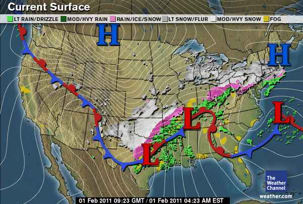
Here’s a surface map from The Weather Channel, at about 3:30 am Central Time:

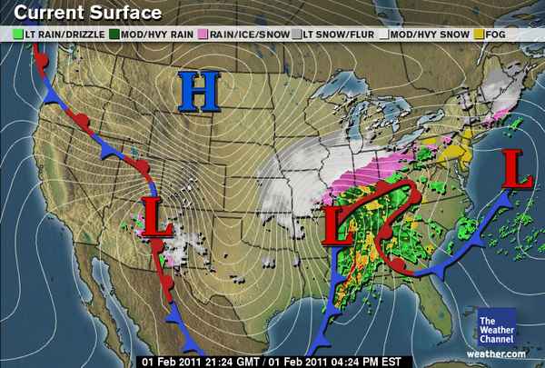
And here’s a map from 12 hours later, showing where the snow and ice has moved on to (there’s also a tornado threat for the Southeast):

Preliminary snow totals for Oklahoma, via the NWS Norman:

Permalink
01.31.11
Posted in Weather Forecast, Weather News, Winter Weather at 3:47 pm by Rebekah
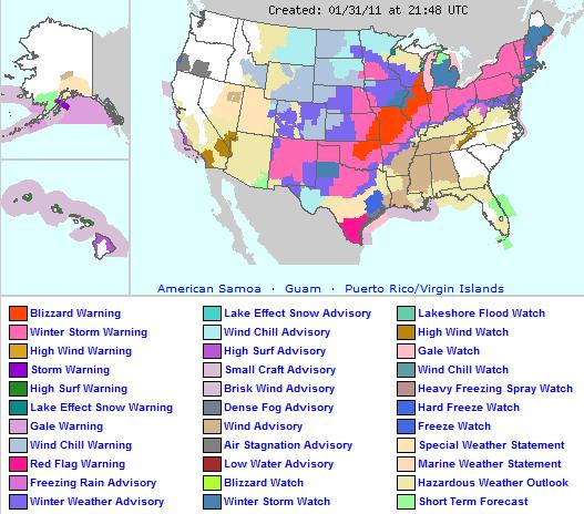
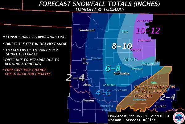
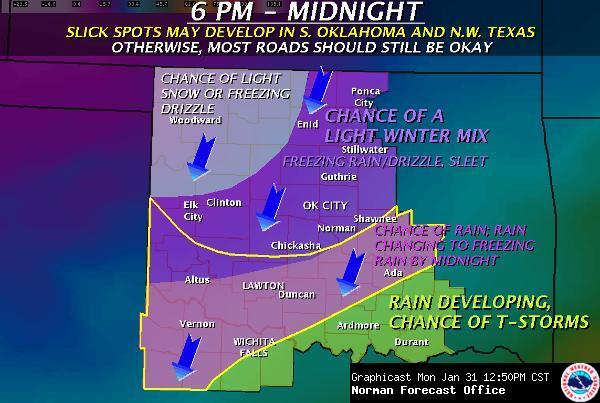
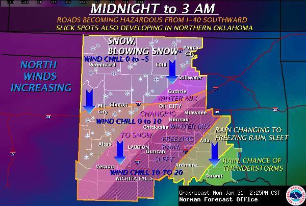
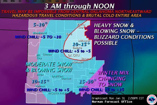
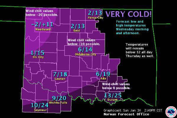
Nearly half of the U.S. and about 1/3 of the nation’s population is bracing for a major winter storm, to take place today through Wednesday or so. Since there’s a lot that could be said, and I don’t have a lot of time for an in-depth post, I’ll just post some graphics from the National Weather Service.


I might add that to my knowledge, this is the first blizzard warning that I have ever been under (I missed the Christmas Eve 2009 blizzard, which was the first blizzard in central Oklahoma in modern history and dumped 13.5 inches of snow on Oklahoma City, with several-foot drifts).
The National Weather Service has been using the following statements to describe this storm (taken from The Weather Channel):
-
Norman, OK: “Obvious analog would be Christmas Eve ’09. For some this may be as bad or worse.“
-
Kansas City, MO: “This could end up being one of the more significant weather events in the last 20 years in Missouri.“
-
St. Louis, MO: “Potentially historic winter storm headed for region.“
-
Milwaukee, WI: “Paralyzing blizzard“
-
Grand Rapids, MI: “Travel…and commerce in general…could be paralyzed with near record-breaking snowfall.“
-
Indianapolis, IN: “Could result in devastating conditions for central Indiana. Long duration power outages appear possible.”
Note: we could get more snow than this, and with the winds, several-foot snow drifts are possible
Currently, here in Norman, it’s mostly cloudy, dry, 45 °F, with a north wind of about 15 mph. It’s hard to believe that within 24 hours we could have several inches of snow on the ground!
Permalink
01.30.11
Posted in Weather News, Winter Weather at 8:00 am by Rebekah
For quite some time now the models have been hinting at the possibility for a decent amount of snow and possibly ice for Oklahoma this week. The models have come to some sort of agreement lately and it’s looking like parts of central to northern Oklahoma could see several inches of snow from Monday night into Tuesday.
There may be some sleet or even freezing rain Monday night as well, but the GFS and the NAM aren’t showing much of a warm layer, if any.
A strong, arctic high (could be as high as 1048 mb or so) will edge down into the Northern Plains, bringing frigid air along with it. The National Weather Service in Norman (Oklahoma) is calling for a low of 7 °F in Norman Tuesday night.
We could certainly use some precipitation…it’s been so dry in the Southern Plains, and numerous fires have broken out in the last couple of days.
These last two days have been nice in terms of temperature, though; yesterday Norman reached 79 °F and today 76 °F! 🙂 I still haven’t turned my heat on…I haven’t had the heat on since March, if not February of 2010. My apartment stays insulated pretty well and so far this winter it hasn’t stayed cold for longer than a couple of days.
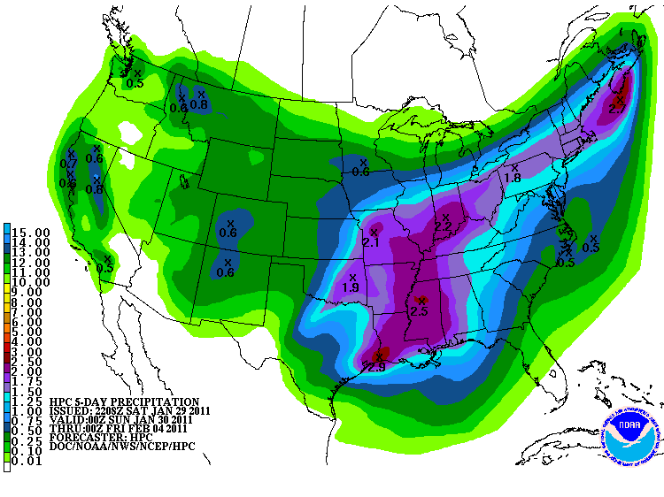
Here’s the 5-day precipitation (liquid-water equivalent) forecast from the Hydrometeorological Prediction Center…looks like it could be wet for much of the U.S. this week!

Permalink
01.28.11
Posted in Winter Weather at 8:00 am by Rebekah
The Knickerbocker Storm was a blizzard that took place along the mid-Atlantic U.S. coast on January 27 – 28, 1922.
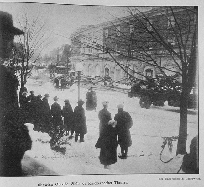
The blizzard was known for the collapse of the Knickerbocker Theatre in Washington, D.C., under the weight of heavy snow. Tragically, 98 people were killed and 133 injured when the cinema’s roof caved in.

The Knickerbocker Theater, following its collapse. Source: NOAA
Meteorological Synopsis
Nearly a week prior to the event, a sub-freezing airmass set in across the Northeast and mid-Atlantic.
A low formed off the coast of Georgia, and rapidly deepened as it began to move up the coast. A strong high pressure system in southeastern Canada prevented the low from moving northward very fast, so it took three days for it to travel up the East Coast, prolonging the event.
On the 27th, heavy snow started to fall from the Carolinas to Pennsylvania with the low off the North Carolina coast. The hardest-hit areas were from Washington, D.C. to Philadelphia. Snow fell in Washington from about noon on the 28th until the morning of the 29th. Snow totals in the city ranged from 28 to 33 inches. This went down as the biggest snowstorm in Washington since official records began in 1885.

Weather Bureau map from the morning of January 28, 1922. Source: NOAA
Impacts
Parts of the Northeast received 20 or more inches of snow, while much of the rest of the Eastern Seaboard received at least 4 inches. Some snow drifts on railroad lines between Philadelphia and Washington were as high as 16 feet.
The Knickerbocker Theatre in Washington, D.C. was just 5 years old and was the biggest cinema in town. The roof was flat, allowing the wet, heavy snow to accumulate and eventually force the roof to collapse. The balcony section came down as well, and dozens of people were buried. Hundreds of rescue workers came to help, some of them comparing the scene to one from World War I. This disaster ranks as one of the worst in Washington’s history.
Permalink
01.22.11
Posted in Weather News, Winter Weather at 8:00 am by Rebekah
National Weather Service offices in the Dakotas and Minnesota decided to start using a new type of warning this week, called an “extreme cold warning“.
An extreme cold warning will be issued when the air temperature is forecast to drop to 40 below zero and lower, with little or calm wind (previously only a wind chill warning could be issued for such cold temperatures, but this is meant to be more for when there is not much wind).
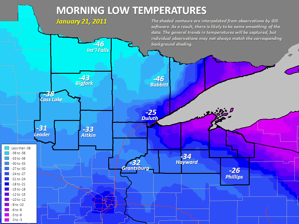
Thursday night, the NWS in Duluth had the chance to issue their first extreme cold warning, and it certainly verified; International Falls recorded a low of 46 below, tied for their 5th lowest temperature on record.

See more info about the cold on the NWS Duluth page here. See also the NWS link to more info on the experimental extreme cold warning.
Permalink
« Previous Page — « Previous entries « Previous Page · Next Page » Next entries » — Next Page »
