01.14.11
Posted in Winter Weather at 8:00 am by Rebekah
On January 12, 1888, an arctic cold front swept through the Great Plains, bringing temperature drops from the upper 30s to minus 20 °F (minus 40 °F in the Northern Plains), strong winds, and heavy snow.
Thousands of people were caught out in the cold and snow, as the blizzard was very sudden, it struck during work and school hours, and many people were outside as the temperatures leading up to the passage of the front were fairly mild. At least 235 people died in the storm, many of them children in the Dakotas and Nebraska, walking home in the blizzard and/or freezing in the arctic temperatures (hence the name “Schoolhouse Blizzard” or “Children’s Blizzard”).

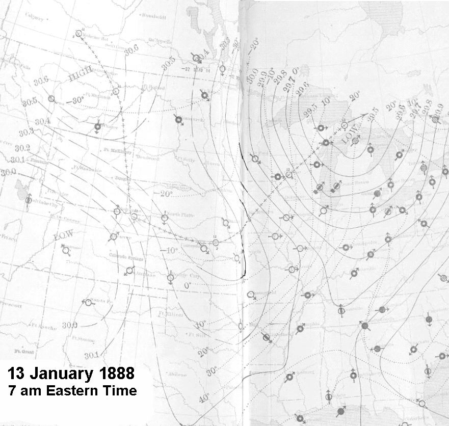
Map of temperatures and pressure on the morning after the blizzard. Click to enlarge. Source: Wikipedia
My grandmother’s grandparents, father, and aunts and uncles got to experience this blizzard from southwest Iowa. Here is the story as she heard it from her father (Julius), some 70 years ago.
Written by Izetta (Kiersch) LaBar:
———————-
BLIZZARD OF JANUARY 12, 1888
The day dawned slightly cloudy, uneventful, and just like all the other January days had been. A foot of snow lay on level places, and the temperature was warm enough to make good snowballs. Frank, Dora, and Charley were through school and at home; also at home, because they were too young to attend school, were John, Agnes, and Harry. Those who attended school that day were Julius and Bertha. At that time the teacher was boarding with the Kierschs.
The day went as usual, with the dismissal at 4 and the sky still somewhat cloudy. The two children and the teacher started home across the field, following an old oxen trail which was already rutted too deep to use in four trails, though a fifth trail was still being used. They dallied along, snowballing as they went, until at about 4:30 the perfect calm of the day was suddenly broken. Without any warning a blizzard was upon them, and they were only halfway home. The gale was so strong they could hardly stand; yet they had to go on. They must keep moving. The teacher kept her head and marched straight west to a fence that they knew very well – it must be there to guide them if they could find it. Straight, straight west, and they reached the fence at last. Now the problem was to follow it south to another fence, which would lead them home. How could they keep their sense of direction so well, did they worry for fear they might be going the wrong way? Who knew what their thoughts were? The snow was soon two feet deeper, but follow the fence they must to the south end of it. At last here was the east and west fence along the familiar county line road; now to follow it west for home. Being worn into a depression the road was already drifted full.
They floundered through the deep snow step by step, and were unable to take one more step when at last they reached the door. There they found mother and Dora in tears, worrying and wailing about the fate that must have overtaken the two children. Such a relief! There was a bustle of removing thoroughly soaked clothing, warming the three up, and finding dry clothing for them. In the midst of the flurry, father stomped in covered from head to foot with blizzard snow. He had survived the two-mile fight along the railroad track from Bill Boehm’s, where he had gone earlier in the day to make a cutter with his neighbor’s help. Even a man of his strength had had his worries too, fighting the icy blasts. His first words, after barely having entered the door were: “Sind die Kinder Heim?” (Are the children home?)
The blizzard blew for three days, making drifts up to the eaves of the house on the south side. The cattle sheds were covered with snow, and the inside was full too, except for in a small spot where the cattle had milled around, and now were standing with their heads and hair all full of snow and ice. Drifts of snow all over the place were so solid, the cattle could walk right over all of the fences.
The trains didn’t come through for a week, but when the snowplow finally showed up it had three locomotives. They got stuck in the cut west of the house, and had to shovel to get backward to make a long run for this six or eight foot drift. Julius, Frank, and August Fieselman were standing above on the bank watching. When they finally got themselves shook off, dug out, and eyes wiped the engines were two miles up the track!
———————-
Permalink
01.11.11
Posted in Weather News, Winter Weather at 9:06 pm by Rebekah

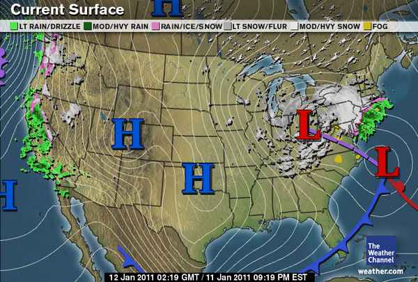
Tonight’s surface analysis from The Weather Channel shows most of the U.S. in the grips of a strong, large area of high pressure. This high pressure has ushered in cold, dry air for much of the U.S.
Perhaps the biggest story tonight, though, is that the low pressure center over Ohio, associated with a deep, upper-level trough, should merge late tonight with the low moving up the Atlantic Coast. This secondary low is what tracked along the Gulf Coast early in the week, aiding in the snow and ice storms of the Southeast.
As the smaller low moves up the coast tonight, an area of upper-level divergence on the east side of the trough (what’s causing the low in Ohio) will cause the surface low to intensify. The two areas of surface low pressure will appear to merge below the trough, and the pressure of the resulting surface low is expected to rapidly drop.
Models are showing that the pressure of this low could drop by 28 millibars in 24 hours, which is well within the definition of a “bomb cyclone” (low pressure center drop of 24 millibars in 24 hours). Currently, the pressure of both lows is about 1012 mb.
This extratropical cyclone / nor’easter is expected to result in several inches of snowfall across the Northeast, starting tonight.
In other news, there is also an extratropical cyclone off the Pacific Coast, and this is responsible for strong winds and rain and wintry precipitation along the West Coast. Western Washington and northwestern Oregon are already receiving snow and freezing rain.
Permalink
01.08.11
Posted in Weather Forecast, Weather News, Winter Weather at 8:00 am by Rebekah
Weather Discussion

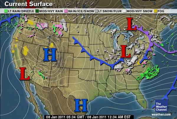
National: The primary features on satellite and upper-air maps are the large low-pressure system over the Northeast and the split-flow over the West, including a shortwave trough over the Northwest, a ridge over the northern Rockies, and a shortwave trough over the Southwest.
Rain and snow is ongoing in the Cascades and northern Rockies, a large surface high is located over the Great Basin, and the mature cyclone over the Northeast is bringing snow to New England and the Ohio River Valley. An arctic front extending across the central part of the country is bringing cold temperatures to the Plains as well as a chance for freezing rain and snow.
Southern Plains: The shortwave trough over the Southwest will dip down into Texas on Sunday, increasing lift and the chances for rain and snow in the wake of the cold front. Ground temperatures will probably be too warm for much snow accumulation; the greatest chance for snow would be in eastern Oklahoma, where temperatures are expected to be colder.
The type of precipitation is rather tricky to forecast for Oklahoma…forecast soundings for central Oklahoma Sunday evening show a saturated profile just at or below freezing. This means snow could fall, but if the temperature winds up just a little warmer than forecast, we could get just rain or even freezing rain. On the other hand, it looks a bit more certain that a snow/sleet event is building for the Arklatex region on Sunday and sleet/freezing rain for the Southeast on Monday and Tuesday.
On Monday, a trough will deepen over the Rockies and the exit region of a jet streak will be over Oklahoma. This will enhance lift and there will be another chance for some wintry precipitation. Forecast soundings for central Oklahoma again show saturated profiles just below freezing. Northern Oklahoma may get a bit more snow on this day.
The cooler weather will continue throughout the week…high temperatures in Oklahoma will primarily be in the 30s, with lows in the 20s. The latter half of the week should remain dry but breezy.
Permalink
01.07.11
Posted in Winter Weather at 8:00 am by Rebekah
From January 5 – 8, 1988, a winter storm dumped over a foot of snow and sleet across the southern United States. Over 3 million chickens were killed in Alabama, Georgia, and Texas, following the collapse of dozens of poultry houses due to the weight of snow and ice.

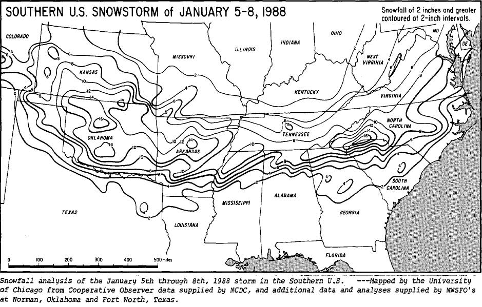
Snowfall totals from the Rockies to the mid-Atlantic coast. Most states affected received at least 8 inches of snow. Far northwestern South Carolina reported an unofficial snowfall total of 27 inches. Courtesy of NCDC/Storm Data. Click to enlarge.
Timeline
- Monday, January 4th: A cold front associated with a deep trough over the central and eastern U.S. brought well-below-average, sub-freezing temperatures deep into the Southeast
- Wednesday, January 6th: A new shortwave trough developed and tracked over the Southern Plains, inducing the formation of a weak surface low just off the Texas Coast…snow was already falling in Oklahoma, and began to fall in far northern Mississippi and Alabama and southern Tennessee
- Thursday, January 7th: The surface low set up near Mobile, Alabama, allowing slightly warmer air to advance northward…this resulted in precipitation changing to sleet and freezing rain…later in the evening, much of the precipitation turned back to snow
- Friday, January 8th: Snow tapered off in the Southeast, although strong winds continued to cause significant snow drifts…meanwhile, the surface low strengthened along the East Coast and brought snow to the mid-Atlantic states and New England
Aftermath
Sub-freezing temperatures continued even after the storm had passed, allowing snow and ice to remain on the ground for several days.
Many schools were closed for the week and roads were closed for days throughout much of the Tennessee River Valley. Many flights in the areas affected were delayed or canceled during the storm. Some power outages lasted for several days in the southern states more affected by the ice.
About 60 people died as a result of the snow and cold this week.
Governor Guy Hunt declared a state of emergency for northern Alabama, after about 2 million chickens were killed due to the collapse of their shelters, resulting in over $15 million of damage. Over half a million chickens also perished in eastern Texas, and another half a million died in northern Georgia.
Sources: NWS Huntsville January 1988 Winter Storm; Winter storm across the nation (Ocala Star-Banner); Dead chickens called public health threat (The Tuscaloosa News); Storm may boost poultry prices (The Dallas Morning News).
Permalink
12.29.10
Posted in Weather News, Winter Weather at 8:01 am by Rebekah
So far for the month of December:
Seattle, Washington has had 8.59 inches of rain (3.65 inches above average).
Denver, Colorado has had NO SNOW (16.4 inches below average); in fact, no precipitation at all (0.55 inches below average).
Newark, New Jersey has had 3.87 inches of precipitation (0.78 inches above average), including 24.5 inches of snow (22 inches above average). [As an aside, check out this 40-second time lapse video from 20 hours of the blizzard in New Jersey on Sunday…it’s very impressive!]
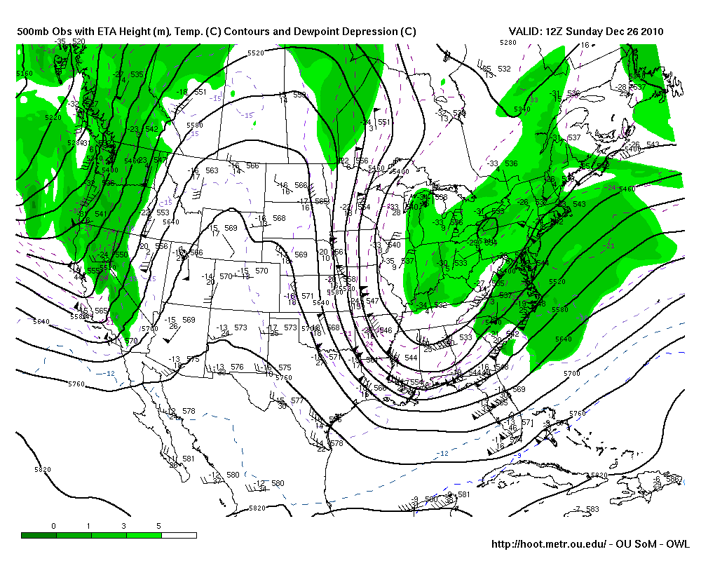
These are just a few stats at specific points, but they serve as examples of what the general weather pattern has been lately: trough in the west, ridge in the central US, and trough in the east.

Sunday (26th) morning’s 500mb map from HOOT, showing a trough in the west, a ridge over the Rockies, and a trough in the east.
This pattern is often conducive to rainy and/or snowy weather along parts of the West Coast, mild and dry weather in the Plains, and cold and snowy weather along parts of the East Coast. This pattern has some relation to La Niña, which I won’t get into in this post (see this post for how this compares to an El Niño pattern from earlier this year).
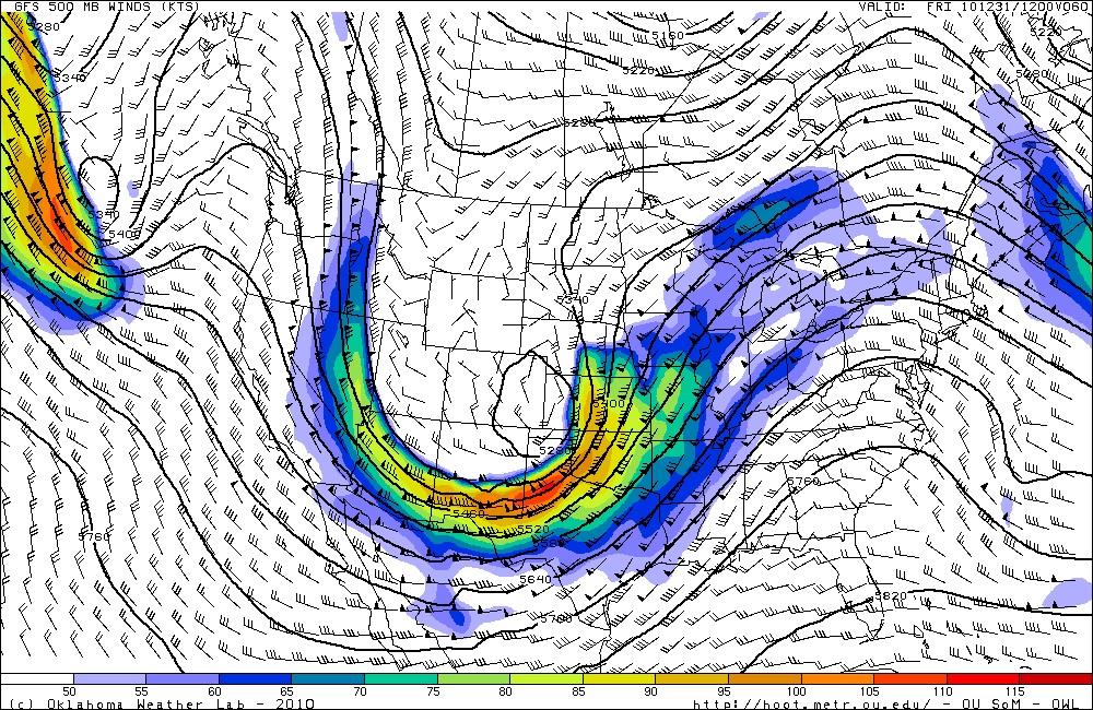
However, it looks like the atmosphere is ready for some change in the new year.
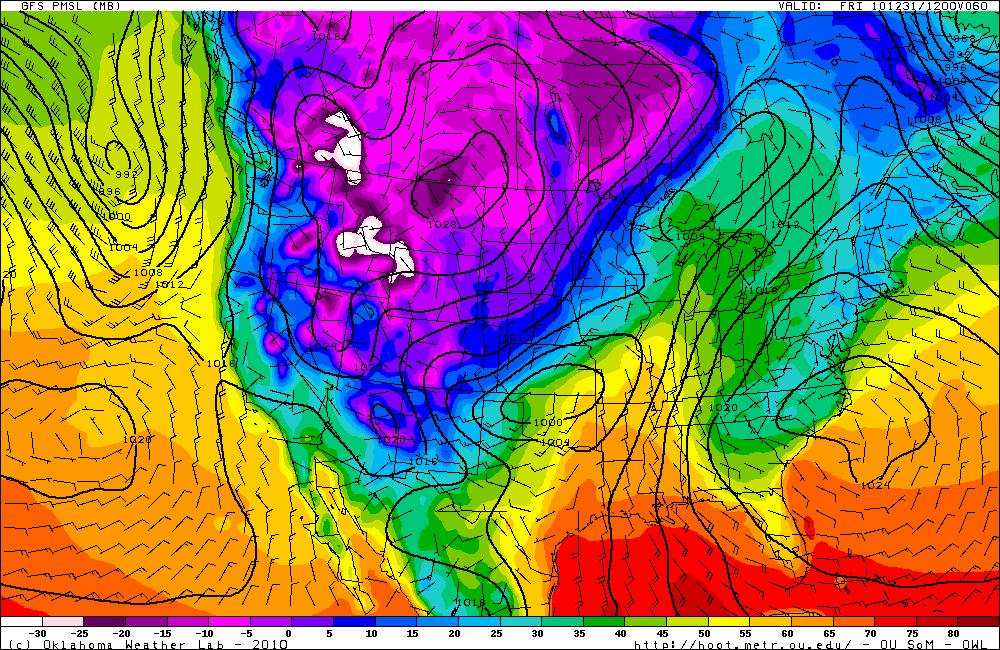
The ridge has been weakening for the last couple of days and moving eastward, which will allow a large trough to deepen and dig in over the western and central US. This will open the door for cold air to surge down into the Plains, and, with the assistance of some upslope winds, will finally allow Denver to receive several inches of snow.

GFS 500mb forecast (from HOOT) for 12Z on New Year’s Eve (i.e., morning of the 31st). Compare to the 500mb map from Sunday (above).

GFS surface analysis forecast (temperature is color-coded) for 12Z on New Year’s Eve. Note the cold air in the western US and the low pressure system over Oklahoma that will move up to Minnesota the next day.
Will we continue to see ridges over the West and troughs (and colder weather) over the central US? Will this just be the beginning of the atmosphere breaking out into a more progressive pattern?
We’ll have to wait and see!
Permalink
« Previous Page — « Previous entries « Previous Page · Next Page » Next entries » — Next Page »
