05.11.11
Posted in Uncategorized at 1:22 pm by Rebekah
Jeff and I are storm chasing today, heading up I-35. We’re near Oklahoma City at present, and are currently targeting Enid, Oklahoma. We may actually drop south of Enid, but we’ll decide that once we get closer.
After this midday convection rolls through central Oklahoma, we may get a fairly nice dryline day in western Oklahoma. I’m actually a bit concerned about there being too many storms popping up.
Permalink
Posted in Uncategorized at 8:00 am by Rebekah
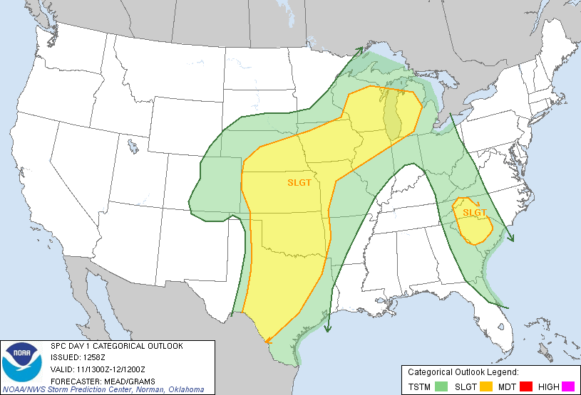
There WAS a moderate risk for severe weather in west central Oklahoma and west central Kansas today…at 13Z, the Storm Prediction Center removed the moderate. A fairly deep trough will set up over Colorado and a surface low will be in western Kansas with a dryline stretching south of the low through western Oklahoma this afternoon.

I’ll be free to chase after about noon, and likely would not have far to go to see supercells and possibly tornadoes.
I’ll see what the day is looking like by midday.
Permalink
05.10.11
Posted in Non-US Weather, Tropical Weather, Weather News at 8:00 am by Rebekah
This week’s post in the global weather and climate series features Kwajalein Island, part of the Kwajalein Atoll of the Republic of the Marshall Islands.
You may know by now that I recently accepted a job offer to work as a forecaster on Kwaj, as the locals call it. I’ll write a lot more about the island later, of course (see my new Kwaj blog here), but I thought I’d do a feature post on Kwaj before I even get there.

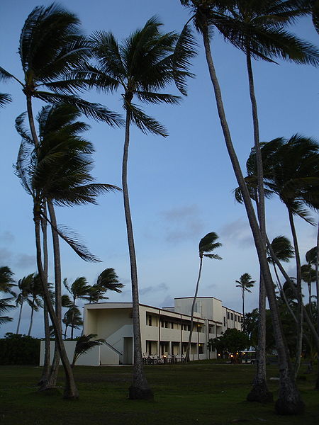
The Kwaj Lodge, for short-term housing but typical of housing on the island. From Wikipedia

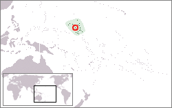
Map showing the location of Kwajalein Atoll, from Wikipedia
Kwajalein Island is a small island on the southern end of the Kwajalein Atoll. An atoll is a series of islands on a coral reef that surrounds a lagoon. Again, I’ll write more on all of this later.
Kwajalein Atoll is part of the Republic of the Marshall Islands, although Kwajalein Island is a U.S. Army base so there really are no locals on this island. The Marshall Islands are way out in the Pacific, and Kwajalein is just north of the equator and just west of the International Date Line.
Kwajalein has a long history, but in short, the Marshall Islands are Micronesian and were taken over by the Japanese some time in the early 1900s. The U.S. fought over (and won) Kwajalein during World War II, and today the island is an army missile testing site (from what I understand the island is sort-of “rented” out to the U.S., although there is much more to it than that).
A few more facts about Kwajalein (weather data from the RTS Weather Station, where I’ll be working):
- Time zone: UTC + 12
- Elevation: near sea level
- Climate zone: Tropical marine
- Average high temperature: 87 °F (30 °C)
- Average low temperature: 78 °F (25 °C)
- Average annual high/low temperature range: 86 to 87 °F (30 to 31 °C) / 78 °F (25 to 26 °C)
- Record high temperature: 97 °F (36 °C)
- Record low temperature: 68 °F (20 °C)
- Average annual rainfall: 80 inches (2,030 mm)
Weather: As you can tell by the statistics, Kwajalein does not have much of a temperature range; the island is typically warm and humid, and I hear there are two seasons: warm and wet, and warm and windy (trade winds).
I look forward to learning a lot more about the tropical weather of Kwajalein before and during my time there. I do know that the island is too close to the equator to get strong typhoons (tropical cyclones), although they may occasionally get sideswiped by weaker cyclones.
As to the weather this week…I’ll guess that highs will be around 86 °F and there may be a chance of thunderstorms! (Check the forecast…yep, that’s about right! Though I know there will be more to my job than just that… 🙂 )
For weather maps and information on current and forecast Kwajalein weather, see the RTS Weather Station, Weather Underground and Weather Online UK (global maps and models).
Here’s a Wikipedia link for Kwajalein Atoll, and here’s a Wikipedia link for the Republic of the Marshall Islands.
Next Tuesday I plan to take a look at the climate and weather in another part of the globe, hopefully just after witnessing a space shuttle launch! As always, if you have any suggestions for future cities, please leave a comment!
Permalink
05.09.11
Posted in Astronomy, Space Shuttle at 11:38 pm by Rebekah
Just a note to say NASA officially set the launch time for Endeavour for 8:56 am Eastern on May 16th (Monday), and I plan to be there! Those of us invited to the NASA Tweetup a week and a half ago will be able to go back to the VIP site to watch the launch. My travel plans are set now, so hopefully it will launch this time!
I’ll fly out Saturday and return Wednesday. Yes, I prefer driving to flying, but I can’t afford to take the time (or money) to turn right around and do the road trip all over again. I still have to post more photos from the recent road trip!
So much to do, so little time…
Permalink
Posted in Weather Education at 8:00 am by Rebekah
The last post in the weather education series (now three weeks ago!) dealt with upper-air maps, including pressure surfaces and the basics of how to read upper-air maps. The last segment of reading weather maps will be on soundings, but I will break it up into two posts.
Soundings
Remember when we discussed upper-air observations? Instruments called radiosondes are attached to balloons and launched into the atmosphere twice a day around the world. Radiosondes collect temperature, pressure, humidity, and wind data.
An atmospheric sounding is a vertical profile of the atmosphere, meant to be representative of the atmospheric conditions at the point at which the balloon was launched.
Soundings are plotted on a variety of charts.
Meteorologists most frequently look at sounding data on a Skew-T Log-P diagram, often just called a Skew-T for short.
Skew-T Log-P Axes
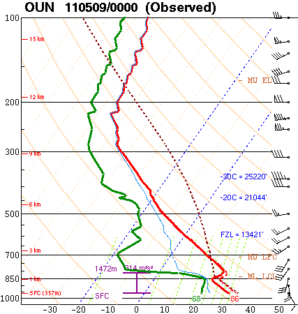
Here is an example of a Skew-T Log-P diagram, showing Norman’s 00Z sounding (7 pm local time on Sunday). The chart came from the Storm Prediction Center, one of my favorite places to look at soundings.

You are looking at a vertical profile here, so the bottom of the chart is the surface, and the top of the chart is up near the top of the atmosphere.
The black numbers on the left side of the diagram are pressure values in millibars (remember 1000 mb is near the average sea-level pressure, 500 mb is near the middle of the atmosphere, and 100 mb is near the top of the atmosphere).
Note the pressure is plotted logarithmically (the hash marks spread out as you go up). This is where the “log-p” of this diagram comes from (logarithmic pressure).
The red numbers on the left side of the diagram are altitude values in kilometers (SFC means the surface, where the balloon was launched).
The black numbers on the bottom of the diagram are temperature values in degrees Celsius. Note the temperature lines are tilted up to the upper right (the light pink dashed lines). This is where the “skew-t” of the diagram comes from (skewed temperature).
Reading A Skew-T
After you understand the main axes on a Skew-T diagram, take a look at the two solid bold lines on the chart.
The red line represents the temperature of the atmosphere, while the green line represents the dewpoint. These lines may be different colors or even the same color on other Skew-T diagrams, so the main thing you should remember is that the dewpoint can never be greater than the air temperature, so the dewpoint line is always on the left and the temperature line is always on the right.
The next thing you should notice is the wind barbs on the right side of the diagram. These wind symbols are the same as those you would see on a surface or upper-air map. Each wind symbol represents the wind speed and direction at that level of the atmosphere.
Ignore all other lines on this diagram for now.
Now you should start to be able to make sense of what is going on in the diagram.
Skew-T Example
The surface temperature and dewpoint have been nicely labeled on this diagram, in degrees Fahrenheit. In this example, the surface temperature is 86 °F and the surface dewpoint is 68 °F.
Note the temperature (red line) decreases with height from the surface up to about 850 mb. The temperature then briefly increases with height (known as a temperature inversion), before going on to decrease with height. The dewpoint follows much the same pattern.
Now look at the winds. The surface wind is out of the southeast at 10 knots (11.5 mph), but the wind direction changes to the west and speed increases with height. When the wind direction changes in a clockwise manner, we say the wind is veering, but when it changes in a counter-clockwise manner, we say the wind is backing. In this case, the wind is veering with height. We will later see that this is a good thing for promoting severe thunderstorm development.
We will spend a lot more time with soundings in the future, so it is important to become familiar with what the basic lines mean.
Soundings plotted by the Storm Prediction Center may be found here.
Soundings plotted by the College of DuPage may be found here (go to Upper-Air Products, Upper-Air Soundings).
Soundings plotted by the Oklahoma Weather Lab (University of Oklahoma School of Meteorology student forecasting lab) may be found here.
————————————————–
Next Monday I plan on discussing another type of upper-air chart, called a hodograph, which we use to quickly assess wind direction and speed with height.
Permalink
« Previous Page — « Previous entries « Previous Page · Next Page » Next entries » — Next Page »
