02.19.11
Posted in Non-US Weather, Tropical Weather, Weather News at 8:00 am by Rebekah
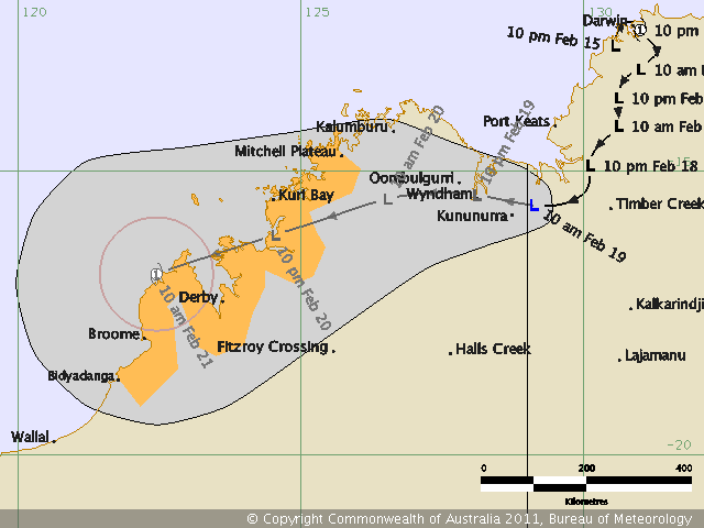
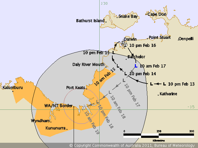
Ex-Tropical Cyclone Carlos just keeps on dancing down the northwestern coast of Australia!

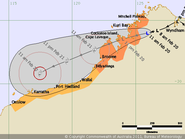
This is so strange…the tropical low was upgraded to tropical cyclone as soon as it moved OFF the coast (would that be a…waterfall? :)), then it came back onshore, swirled around Darwin and dumped over 2 feet of rain on the area in about 3 days (over half the average February rainfall). Now it’s still being recognized as a tropical low. Carlos is close to making it offshore again, but really has the best chance in a couple of days, when the low could become a Category 1 cyclone again.
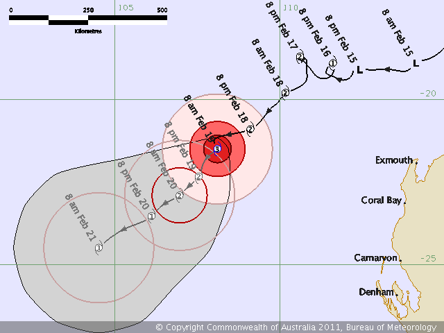
Oh, and in the meantime, Category 3, Severe Tropical Cyclone Dianne is off the west coast of Australia, actually acting more in character for a tropical cyclone (well, except for the couple of little loop-de-loops the Bureau of Meteorology had her taking). Dianne isn’t expected to make landfall, but to gradually weaken.

EDIT: The Bureau of Meteorology now has Carlos getting to a Category 2!

Permalink
02.18.11
Posted in General News, Photography at 8:00 am by Rebekah
For today’s blog I was thinking about discussing the possibility of severe storms next week, but as it looks like that isn’t going to happen now, I thought I’d take a moment to introduce my sister’s new blog.

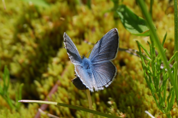
Photo by Caitlin LaBar
While I’m out chasing tornadoes, Caitlin chases butterflies. She’s always been interested in studying insects, and she’s one of the smartest people I know when it comes to insects, especially butterflies and moths of the Pacific Northwest.
This is what her new blog will focus on: “observing, rearing, and collecting butterflies and moths in the Pacific Northwest. My goal is to post a new entry at least once a week, on topics involving personal observations, how-to guides, “biographies” of local Lepidoptera species, and photographic journals of my exploits.”
So if any of you have any interest in butterflies or insects in general (or know someone who does), especially for those that live in the Pacific Northwest, I encourage you to check out her site, and bookmark the site as there will be more coming soon.
Also, Caitlin is an excellent photographer; her photos of insects look just like ones you’d see in an identification book. She also takes great photos of birds, and has already started posting some of those.
The blog site is Northwest Butterflies (http://northwestbutterflies.blogspot.com/). Enjoy!
————
I now return you to your regularly scheduled weather blog.
PS: The Storm Prediction Center has recently put “predictability too low” in the day 4 to 8 forecast, instead of “potential too low”…that could be a good sign for even garden variety thunderstorms soon…
Permalink
02.17.11
Posted in Non-US Weather, Tropical Weather, Weather News at 8:00 am by Rebekah
Check this out! Isn’t the track of this low bizarre?

Ex-Tropical Cyclone Carlos’ path. From the Bureau of Meteorology
Darwin, Australia has received over 2 feet of rain from this system over the past 3 days or so, and the winds have toppled a number of trees!
Permalink
02.16.11
Posted in Severe Weather Forecast at 8:00 am by Rebekah
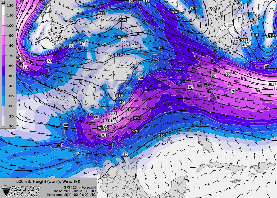
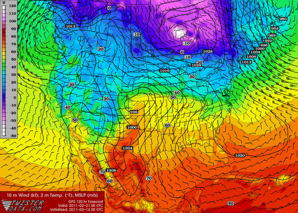
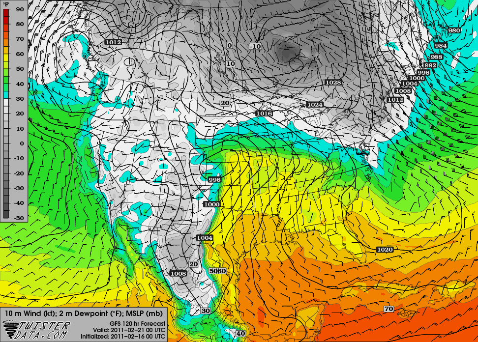
A quick look at last night’s 00Z GFS run for 00Z Monday, or 6 pm Central Time on Sunday (bound to change, but it can be interesting to look at trends as it gets closer):
500 mb shows a nice little shortwave trough centered over New Mexico:

Surface temperatures in the lower 60s in western Kansas and western Oklahoma, with a surface low over western Kansas…surface winds in central Kansas are from the south-southeast:

Surface dewpoints in the lower 50s up through central and eastern Kansas:

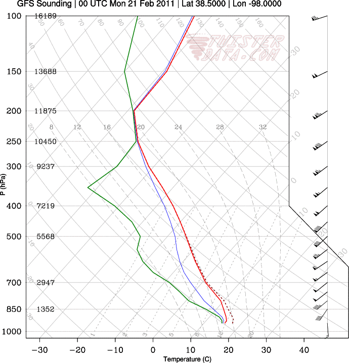
Sounding from Hutchinson, Kansas…would be nice if the high clouds would be gone and the surface could warm up a bit more…but hey, it’s February:

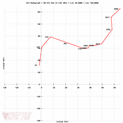
Hodograph for Hutchinson also shows decent wind shear:

Does this mean severe storms are returning to the Plains? No. But even thunderstorms of the non-severe variety would be welcome at this point, and the models are certainly showing some hope of that.
If moisture return is any greater, surface temperatures any higher, and the winds are a little more backed (more out of the southeast), I would be happier and might even consider a jaunt to Kansas, but this is still not a bad setup for February storms. We’ll have to wait and see. There may be another few setups coming soon as well…but a lot of this is still in wishcasting land!
Maps from TwisterData.
Permalink
02.15.11
Posted in Non-US Weather, Weather News, Winter Weather at 8:00 am by Rebekah
This week’s post in the global weather and climate series features Gangneung (Kangnŭng), Gangwon-do, South Korea.

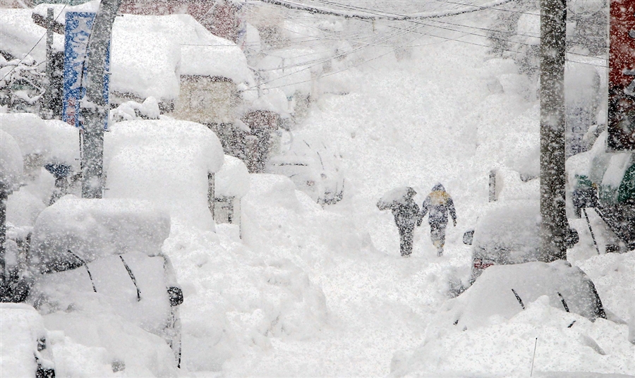
Heavy snow in Gangneung on Feb. 14, 2011. Photo by Lee Sang-hak / Yonhap via Reuters
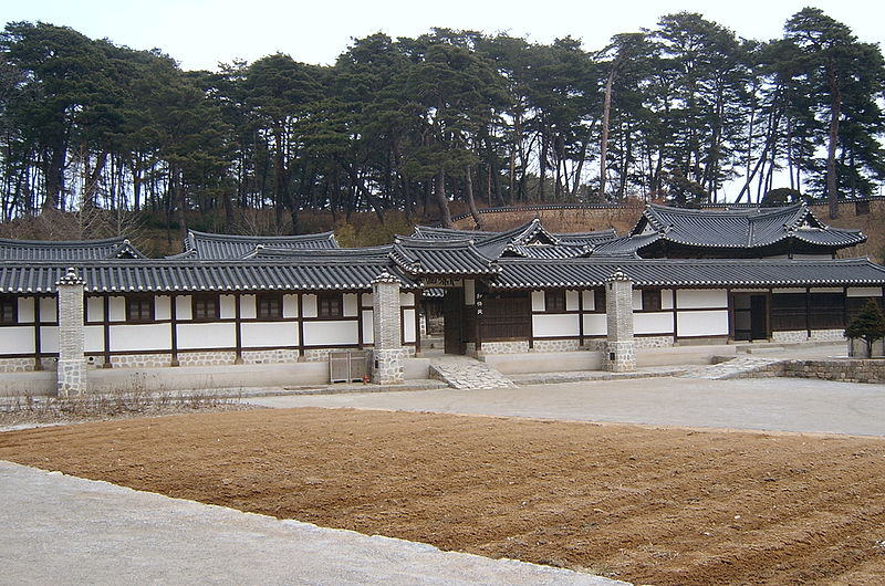
Gangneung (Kangnŭng) is a city of about 230,000 people in Gangwon-do province, South Korea. Situated on the east coast of the country, Gangneung lies between the Sea of Japan (East Sea) and the Baekdu mountain ridge. The beautiful valleys and mountains around Gangneung, as well as the pine forests and sandy beaches, make this city a popular tourist destination. There are also many festivals that take place in Gangneung.

Seongyojang, a 19th century country house outside of Gangneung. From Wikipedia
A few more facts about Gangneung (from Wikipedia):
- Time zone: Korea Standard Time (UTC+9)
- Elevation: varies…from about 30 ft (9 m) to around 100 ft (30 m)…higher in the hills
- Climate zone: Humid subtropical
- Average high temperature: 63 °F (17 °C)
- Average low temperature: 48 °F (9 °C)
- Average annual high/low temperature range: 41 to 83 °F (5 to 28 °C) / 26 to 70 °F (-3 to 21 °C)
- Average annual precipitation: 55 inches (1,402 mm)
Weather: Eastern South Korea has been experiencing record snowfalls lately. Gangneung recently observed a 24-hr snowfall of 30.6 inches (77.7 cm), the greatest 24-hr snowfall since records began in 1911. This heavy snow caused hundreds of roofs to collapse and stranded cars in huge drifts of snow.
High temperatures this week are expected to be in the mid to upper 30s (°F), with lows around 20 °F. Snow is not uncommon this time of year, but this has been an uncommonly cold winter for North Korea and snowy winter for eastern South Korea. Newspapers in South Korea are calling this a “snow bomb”, similar to recent US terms popularized by the media such as “snowpocalypse” and “snowmaggedon”.
For weather maps and information on current and forecast Gangneung weather, see Weather Underground and Weather Online UK (maps and models).
For more information on Gangneung, here’s a link to Wikipedia.
Next Tuesday I plan to take a look at the climate and weather in another part of the globe. As always, if you have any suggestions for future cities, please leave a comment!
Permalink
« Previous Page — « Previous entries « Previous Page · Next Page » Next entries » — Next Page »
